
Ewing Township is a township in Mercer County, New Jersey, United States. The township is within the New York metropolitan area as defined by the United States Census Bureau. It also directly borders the Philadelphia metropolitan area and is part of the Federal Communications Commission's Philadelphia Designated Market Area. As of the 2010 United States Census, the township's population was 35,790, reflecting an increase of 83 (+0.2%) from the 35,707 counted in the 2000 Census, which had increased by 1,522 (+4.5%) from the 34,185 counted in the 1990 Census.

Thomas Cadwalader (1707–1779) was an American physician in Philadelphia. After studying medicine with his uncle Dr. Evan Jones, he traveled to London to study medicine where he was an understudy of William Cheselden. In France he probably attended lectures at Rheims University. He lived for a while near Trenton, New Jersey, where he became the chief burgess in 1746. After returning to Philadelphia, he was elected in 1751 to the city's Common Council. He served on Pennsylvania's Provincial Council from 1755 until the Revolution. He was one of the founders of the Pennsylvania Hospital in 1751. Dr. Cadwalader was one of the first to inoculate patients against smallpox He was a founder and director of the Library Company of Philadelphia and a member of the American Philosophical Society.

North Trenton is a neighborhood located within the city of Trenton in Mercer County, New Jersey, United States.

West Trenton is a section of Ewing Township in Mercer County, New Jersey, United States. It is a suburban area located adjacent to the northwestern portion of the city of Trenton, from which it derives its name. Located at the intersection of Bear Tavern Road/Grand Avenue and West Upper Ferry Road, it is one of the oldest settlements in Ewing Township.

Eastern Parkway is a major boulevard that runs through a portion of the New York City borough of Brooklyn. Designed by Frederick Law Olmsted and Calvert Vaux, it was the world's first parkway, having been built between 1870 and 1874. At the time of its construction, Eastern Parkway went to the eastern edge of Brooklyn, hence its name.

Highland Heights–Stevens' Subdivision Historic District is a residential historic district located in Highland Park, Michigan along five east-west streets: Farrand Park, McLean Street, Colorado Street, Rhode Island Street, and Massachusetts Street, between Woodward Avenue on the west and Oakland Avenue on the east. The district was listed on the National Register of Historic Places in 1988.
Parkside East Historic District is a national historic district located at Buffalo in Erie County, New York. The district is architecturally and historically significant for its association with the 1876 Parks and Parkways Plan for the city of Buffalo developed by Frederick Law Olmsted. It consists of 1,769 contributing structures developed from 1876 to 1936, as a middle class residential neighborhood. The district largely contains single-family dwellings, built in a variety of popular architectural styles, and located along the irregular and curvilinear street pattern developed by Olmsted. The district is located to the east of Buffalo's Delaware Park and includes the Walter V. Davidson House and the separately listed Darwin D. Martin House, both designed by Frank Lloyd Wright.

Parkside West Historic District is a national historic district located at Buffalo in Erie County, New York. The district is architecturally and historically significant for its association with the 1876 Parks and Parkways Plan for the city of Buffalo developed by Frederick Law Olmsted in 1876. It consists of 137 contributing structures developed primarily from 1923 to 1940, as a middle class residential neighborhood. The district largely contains single-family dwellings, built in a variety of popular architectural styles, and located along the irregular and curvilinear street pattern developed by Olmsted. They include homes along Nottingham Terrace and Middlesex Road, and segments of Meadow Road, Lincoln Parkway, Delaware Avenue, and Amherst Street. The district is located to the north of Buffalo's Delaware Park.

Cadwalader Park is a city park located in Trenton, Mercer County, New Jersey, United States. The nearly 100 acres (0.40 km2) green space is Trenton's oldest park. It is named for Thomas Cadwalader, who lived for a while near Trenton where he became the chief burgess in 1746. Trenton's "central park" was designed by Frederick Law Olmsted.
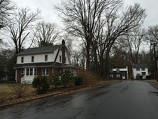
Wilburtha is a section of Ewing Township in Mercer County, New Jersey, United States. Located where Wilburtha Road crosses the Delaware and Raritan Canal, it is one of the oldest settlements in Ewing Township and developed due to the construction of the canal in the early 19th century. The community was known as Greensburg before adopting its current name in 1883. The Yardley–Wilburtha Bridge once connected Wilburtha to Yardley, Pennsylvania on the other side of the Delaware River. Today, Wilburtha is primarily a residential neighborhood consisting of detached, single-family homes, the majority of which were built in the 1950s through the early 1980s.

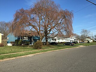
Parkway Village is a neighborhood located within Ewing Township in Mercer County, New Jersey, United States. It is a residential neighborhood primarily consisting of detached, single-family Cape Cod-style homes built in the 1940s and 1950s.

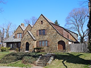
Prospect Heights is a neighborhood located within Ewing Township in Mercer County, New Jersey, United States. It is a residential neighborhood primarily consisting of detached, single-family homes built in the 1920s through the 1970s.

Braeburn Heights is a neighborhood located within Ewing Township in Mercer County, New Jersey, United States. It is a residential neighborhood primarily consisting of detached, single family homes built from the 1940s through the 1970s.

Weber Park is a neighborhood located within Ewing Township in Mercer County, New Jersey, United States. It is a residential neighborhood consisting of a mixture of detached, single-family homes and semi-attached, half-duplexes built in the 1920s through the 1950s. It is adjacent to the Hillcrest section of Trenton.

Hiltonia is a neighborhood located within the city of Trenton in Mercer County, New Jersey, United States. Hiltonia is just northwest of Cadwalader Park.

Hillcrest is a neighborhood located within Trenton in Mercer County, New Jersey, United States. It is adjacent to the Weber Park section of Ewing. Hillcrest is just northeast of Cadwalader Park.

The Island is a neighborhood in the city of Trenton in Mercer County, New Jersey, United States. It is primarily a residential neighborhood consisting of detached, single-family homes and semi-attached (twin) residences built in the 1920s.

Parkside is a neighborhood located within the city of Trenton in Mercer County, New Jersey, United States. Parkside is just southwest of Cadwalader Park.
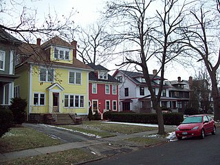
Berkeley Square, also known as Cadwalader Place, is a neighborhood located within the city of Trenton in Mercer County, New Jersey, United States. It is primarily a residential neighborhood consisting of detached, single-family homes constructed in the late 19th century and early 20th century. As an extremely early example of suburbia, it was listed on the National Register of Historic Places in 1980.
Sherbrooke Manor is a neighborhood located within Ewing Township in Mercer County, New Jersey, United States.


