Independence Township is a charter township of Oakland County, in the U.S. state of Michigan.

Ewing Township is a township in Mercer County, New Jersey, United States. The township is within the New York metropolitan area as defined by the United States Census Bureau. It also directly borders the Philadelphia metropolitan area and is part of the Federal Communications Commission's Philadelphia Designated Market Area. As of the 2010 United States Census, the township's population was 35,790, reflecting an increase of 83 (+0.2%) from the 35,707 counted in the 2000 Census, which had increased by 1,522 (+4.5%) from the 34,185 counted in the 1990 Census.

Hopewell is a borough in Mercer County, New Jersey, United States. As of the 2010 United States Census, the borough's population was 1,922, reflecting a decline of 113 (-5.6%) from the 2,035 counted in the 2000 Census, which had in turn increased by 67 (+3.4%) from the 1,968 counted in the 1990 Census.
Hopewell Township is a township in Mercer County, New Jersey, United States. The township is within the New York metropolitan area as defined by the United States Census Bureau, but directly borders the Philadelphia metropolitan area and is part of the Federal Communications Commission's Philadelphia Designated Market Area. As of the 2010 United States Census, the township's population was 17,304, reflecting an increase of 1,199 (+7.4%) from the 16,105 counted in the 2000 Census, which had in turn increased by 4,515 (+39.0%) from the 11,590 counted in the 1990 Census.
Interstate 95 (I-95) is a major Interstate Highway that traverses nearly the full extent of the East Coast of the United States, from Florida to Maine. In the state of New Jersey, it runs along much of the mainline of the New Jersey Turnpike, as well as the Pearl Harbor Memorial Extension, and the New Jersey Turnpike's I-95 Extension to the George Washington Bridge for a total of 77.96 mi (125.46 km). Located in the northeastern part of the state near New York City, the 11.03-mile (17.75 km) Western Spur of the New Jersey Turnpike, considered to be Route 95W by the New Jersey Department of Transportation (NJDOT), is also part of I-95.
County Route 518 is a county highway in the U.S. state of New Jersey. The highway extends 20.58 miles (33.12 km) from Route 165 in Lambertville to Lincoln Highway in Franklin Township. It is also known as the Georgetown Franklin Turnpike.

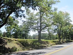
Stoutsburg is an unincorporated community located along the border of Hopewell Township in Mercer County and Montgomery Township in Somerset County, New Jersey, United States. County Route 518 passes through the community from the east and west, while Province Line Road passes through north and south. Province Line Road follows the Keith line which formerly separated the provinces of West Jersey and East Jersey, now parts of Hopewell and Montgomery townships respectively.

Prospertown is an unincorporated community located within the New Jersey townships of Jackson and Plumsted in Ocean County and Upper Freehold in Monmouth County. The community is home to Prospertown Lake and is adjacent to Six Flags Great Adventure, both located on County Route 537. The center of the community is located at the intersection of CR 537, Hawkin Road, and Emleys Hill Road. Most of the area consists of pine forests but there are some homes along the roads in the area.
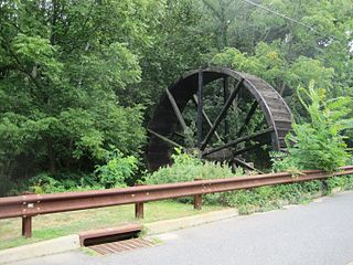
Bucks Mill is an unincorporated community located within Colts Neck Township, in Monmouth County, New Jersey, United States. Bucks Mill Road is the main road that passes north and south through the area; County Route 537 travels to the south of Bucks Mill, near the Hominy Hill Golf Course. Homes, equestrian facility and horse farms, and the township-owned Bucks Mill Recreational Area are located in the area. The settlement is named for Bucks Mill, a gristmill that derived its power from a watermill on the Yellow Brook. Originally built in 1854 and owned for many years by William Buck, Alfred Buck, and Garrett Buck, it was destroyed by a fire on October 30, 1967. The watermill is the only remaining artifact of the original complex and stands today on the side of Bucks Mill Road.

Centerville is an unincorporated community located within Hopewell Township in Mercer County, New Jersey, United States. The community is located at the intersection of Pennington-Rocky Hill Road and Titus Mill Road. Bristol-Myers Squibb's Hopewell Campus is located in Centerville.

Ackors Corner is an unincorporated community located within Hopewell Township in Mercer County, New Jersey, United States. The settlement is located at the intersection of Bear Tavern Road / Trenton-Harbourton Road, Pennington-Harbourton Road and Pleasant Valley Road. It is named for the Ackors family which owned land near the current intersection. Small residences and farmland make up the area surrounding Ackors Corner but the area rises in elevation from east to west as one approaches Baldpate Mountain, part of the Sourland Mountain range.

New Canton is an unincorporated community located along the border of Robbinsville Township in Mercer County and Upper Freehold Township in Monmouth County, New Jersey, United States. The area was once known as Cabbagetown and has been settled since the 18th century. The settlement is located at the intersection of Old York Road and New Canton-Stone Tavern Road just north of Interstate 195's interchange 8. The Upper Freehold side of the area contains farmland and new housing developments while the Robbinsville side features new commercial warehouse buildings including an Amazon.com Fulfillment Center opened in July 2014.

New Sharon is an unincorporated community located along the border of Robbinsville Township in Mercer County and Upper Freehold Township in Monmouth County, New Jersey, United States. Old York Road passes through the center of the community.

Pages Corners or Pages Corner is an unincorporated community located within Robbinsville Township in Mercer County, New Jersey, United States. The intersection defining the corners is at Sharon Road and Gordon Road. The intersection is at a skewed angle which led to numerous accidents. The township installed a traffic signal at the intersection and activated it on September 25, 2015.
Lawrence Station is an unincorporated community located within Lawrence Township in Mercer County, New Jersey, United States. The settlement is named for a former railroad station on the Pennsylvania Railroad's New York Division line, now a part of the Northeast Corridor. Today, some wooded areas and buildings from the time of the station remain but more townhouse developments, cultural centers, and industrial facilities are located along the main road through the area, Lawrence Station Road.

Berrien City, also known simply as Berrien, is an unincorporated community located within West Windsor Township in Mercer County, New Jersey, United States. The area is located within the Princeton Junction census designated place centered about the intersection of Alexander Road and Scott Avenue, located within walking distance of the Princeton Junction train station and Princeton-Hightstown Road. It was developed as an upper-middle class development after World War I and features homes constructed about 100 years ago. Most of the homes still exist with some small businesses located along Alexander Road with the West Windsor Arts Center operating its facilities out of the former Princeton Junction Fire Company fire station.
Zion is an unincorporated community along the border of Hillsborough Township and Montgomery Township in Somerset County, New Jersey, United States. It is located on Rock Brook, approximately 3 mi (4.8 km) north of Hopewell.

Charleston Springs is an unincorporated community located within Millstone Township in Monmouth County, New Jersey, United States. Stage Coach Road, also designated County Route 524, is the main road that runs through the settlement, with Ely Harmony Road as the intersecting road defining the locality. The Manalapan Brook runs to the west of the center of Charleston Springs and CR 537 runs to the south of the area. The Monmouth County-owned Charleston Springs Golf Course is located one mile (1.6 km) northeast of the center of Charleston Springs on CR 527.

Sharon is an unincorporated community located within Upper Freehold Township in Monmouth County, New Jersey, United States. Located at the intersection of Herbert Road and Sharon Station Road, the settlement is the site of a former stop on the Pemberton and Hightstown Railroad. Except for a few single-family homes in the area, most of the area is farmland. The railroad has since been abandoned and is being converted to the Union Transportation Trail, a rail trail. Sharon is the current northern terminus of the trail.

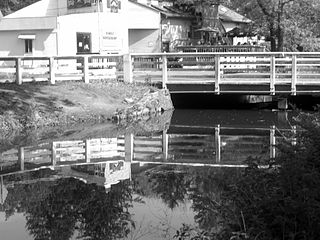
Spring Mill is an unincorporated community located within Upper Freehold Township in Monmouth County, New Jersey, United States. The settlement is located along County Route 524 between Hamilton Township and Allentown on a commercialized segment of the road originally built as New Jersey Route 37. A vestige of the state construction remains along the road through a wide right-of-way and a bridge crossing Doctor's Creek stating that it was constructed by the state in 1940 for State Highway Route 37.