Interstate 78 (I-78) is an east–west Interstate Highway in the Northeast United States, running 144 miles (231 km) from I-81 northeast of Harrisburg, Pennsylvania, through Allentown, Pennsylvania, and western and northern New Jersey to the Holland Tunnel and Lower Manhattan in New York City.

Colts Neck Township is a township in Monmouth County, New Jersey, United States. It is located in the New York Metropolitan Area. As of the 2010 United States Census, the population was 10,142, reflecting a decline of 2,189 (-17.8%) from the 12,331 counted in the 2000 Census, which had in turn increased by 3,772 (+44.1%) from the 8,559 counted in the 1990 Census.
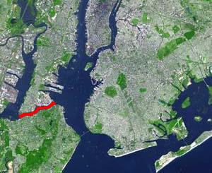
The Kill Van Kull is a tidal strait between Staten Island, New York and Bayonne, New Jersey in the United States. It is approximately 3 miles (4.8 km) long and 1,000 feet (305 m) wide and connects Newark Bay with Upper New York Bay. The Robbins Reef Light marks the eastern end of the Kill, Bergen Point its western end. It is spanned by the Bayonne Bridge and is one of the most heavily traveled waterways in the Port of New York and New Jersey.
New Barbadoes Township was a township that was formed in 1710 and existed in its largest extent in pre-American Revolutionary War times in Bergen County, New Jersey. The Township was created from territories that had been part of Essex County that were removed by royal decree and added to Bergen County. After many departures, secessions and deannexations over the centuries, New Barbadoes Township exists today as Hackensack, which adopted its present name in 1921.
European colonization of New Jersey started soon after the 1609 exploration of its coast and bays by Sir Henry Hudson. Dutch and Swedish colonists settled parts of the present-day state as New Netherland and New Sweden. In 1664 the entire area, surrendered to the English, gained its current name. With the Treaty of Westminster in 1674 London formally gained control of the region; it retained that control until the American Revolution.

Snake Hill is an igneous rock intrusion jutting up from the floor of the Meadowlands in southern Secaucus, New Jersey, at a bend in the Hackensack River. It was largely obliterated in the 1960s by quarrying that reduced the height of some sections by one-quarter and the area of its base by four fifths. The diabase rock was used as building material in growing areas like Jersey City. The remnant of the hill is the defining feature of Laurel Hill County Park. The high point, a 203-foot graffiti-covered inselberg rock formation, is a familiar landmark to travelers on the New Jersey Turnpike's Eastern Spur, which skirts the hill's southern edge. The crest of the hill's unusual, sloping ridge is about 150 feet high.
Dutch Neck is an unincorporated community located within West Windsor Township in Mercer County, New Jersey, United States. The community is centered about the intersection of Village Road and South Mill Road and has in the vicinity numerous churches, West Windsor Volunteer Fire Company No. 1, Dutch Neck Elementary School, and many residences. The community was founded by the Voorhees and Bergen families c. 1737.

New Barbadoes Neck is the name given in the colonial era for the peninsula in northeastern New Jersey, USA between the lower Hackensack and Passaic Rivers, in what is now western Hudson County and southern Bergen County. The neck begins in the south at Kearny Point in the Newark Bay and is characterized by a ridge along the west and part of the New Jersey Meadowlands on the east.

Achter Kol was the name given to the region around the Newark Bay and Hackensack River in northeastern New Jersey by the first European settlers to it and was part of the 17th century province of New Netherland, originally administered by the Dutch West India Company. At the time of their arrival, the area was inhabited by the Hackensack and Raritan groups of Lenape.
Bergen was a part of the 17th century province of New Netherland, in the area in northeastern New Jersey along the Hudson and Hackensack Rivers that would become contemporary Hudson and Bergen Counties. Though it only officially existed as an independent municipality from 1661, with the founding of a village at Bergen Square, Bergen began as a factory at Communipaw circa 1615 and was first settled in 1630 as Pavonia. These early settlements were along the banks of the North River across from New Amsterdam, under whose jurisdiction they fell.

Bergen Neck is the peninsula between the Upper New York Bay and the Newark Bay in the Hudson County, New Jersey municipalities of Bayonne and Jersey City. Its southernmost tip, Bergen Point, is separated from Staten Island by the Kill van Kull, which is crossed by the Bayonne Bridge.
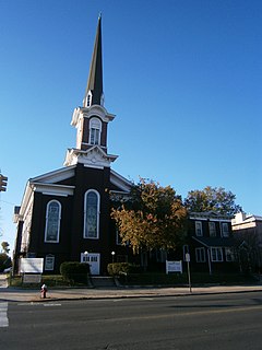
The First Reformed Dutch Church of Bergen Neck, now known as The First Federated Church of Bayonne is located in Bayonne, Hudson County, New Jersey, United States. The church was added to the National Register of Historic Places on April 22, 1982.
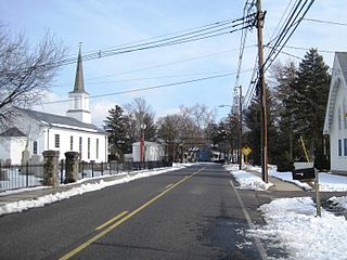
Montrose is an unincorporated community located near the intersection of Dutch Lane Road and Boundary Road along the border of Colts Neck and Marlboro townships in Monmouth County, New Jersey, United States. The town was located in "Atlantic Township" at one time prior to the name being changed to "Colts Neck". Prior to being called Montrose, the area was called "Barrentown".

Penns Neck is an unincorporated community located within West Windsor Township in Mercer County, New Jersey, United States. The community developed at the intersection of the Trenton-New Brunswick Turnpike and Washington Road. The Penns Neck Circle and the historic Penns Neck Baptist Church (1812) are both located in Penns Neck. The Princeton Branch rail line, known as the Dinky, has run through the area since 1865, and stopped at Penns Neck station until January 1971.
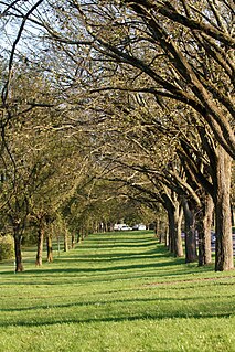
The Washington Road Elm Allée is a 0.7-mile-long (1.1 km) stretch of Washington Road in West Windsor, New Jersey that is lined with Princeton Elm trees. The allée runs through the West Windsor fields of Princeton University and provides, along with the bridge over Lake Carnegie, a dramatic entrance to the campus. The Delaware and Raritan Canal can be found at the northern end of the allée, just before the lake. A jogging path runs through the allée and connects to the canal towpath, the main campus of the university, and other trails through the adjacent fields.
Penns Neck or Penn's Neck may refer to:

Dutch Neck is a census-designated place (CDP) in Cumberland County, New Jersey, United States. It is in the northwestern part of the county, in the southern part of Hopewell Township. It is 4 miles (6 km) southwest of Bridgeton, the county seat.