
Route 31 is a state highway in New Jersey, United States. It runs 48.93 mi (78.75 km) from U.S. Route 1 Business /US 206 in Trenton, Mercer County, north to an intersection with US 46 in Buttzville in White Township, Warren County. Along the way, Route 31 heads through the communities of Flemington, Clinton, and Washington. Most of the highway is state-maintained; however, the section within the city limits of Trenton is maintained by the city. Much of Route 31 is a two-lane highway that passes through farmland, woodland, and mountainous areas. Two portions of the route—from Trenton to Pennington and from Ringoes to Clinton—consist of more development.

Ewing Township is a township in Mercer County, in the U.S. state of New Jersey. The township falls within the New York metropolitan area as defined by the U.S. Census Bureau. It borders the Philadelphia metropolitan area and is part of the Federal Communications Commission's Philadelphia Designated Market Area. As of the 2020 United States census, the township's population was 37,264, its highest decennial count ever and an increase of 1,474 (+4.1%) from the 35,790 recorded at the 2010 census, which in turn reflected an increase of 83 (+0.2%) from the 35,707 counted in the 2000 census.
Route 175 is a short, 2.95-mile (4.75 km) long state highway in Mercer County, New Jersey, United States. The route runs along a former alignment of Route 29 before the construction of the John Fitch Parkway in the 1960s. The route begins at Route 29 in the capital city of Trenton, running along Sanhican Road, River Road, and West Upper Ferry Road into Ewing Township. The route serves primarily as a frontage road for Route 29. The northernmost portion of Route 175 is parallel to the Delaware and Raritan Canal until coming to an end at a merge with Route 29 in Ewing Township.

Route 168 is a 10.75-mile (17.30 km) state highway in the southern part of New Jersey. The route's southern terminus is an interchange with Route 42 and the Atlantic City Expressway in the Turnersville section of Washington Township, Gloucester County. The northern terminus is an intersection with County Route 603 on the border of Camden and Woodlynne in Camden County. At this point, the route continues toward downtown Camden as CR 605. Route 168 follows the Black Horse Pike for most of its length, running through suburban areas in Gloucester Township, Runnemede, Bellmawr, and Mount Ephraim. It intersects many major roads, including the Route 42 freeway in Gloucester Township, Route 41 in Runnemede, the New Jersey Turnpike and Interstate 295 (I-295) in Bellmawr, Route 76C in Haddon Township, and U.S. Route 130 in Camden.
Botzum was a hamlet in Northampton Township, Summit County, Ohio around what is now the intersection of Bath and Riverview Roads in Akron and Cuyahoga Falls.

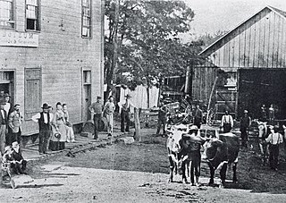
Raritan Landing is a historical unincorporated community located within Piscataway Township in Middlesex County, in the U.S. state of New Jersey, which was once an inland port, the farthest upstream point ocean-going ships could reach along the Raritan River, across from New Brunswick. Begun in the early 18th century it remained vital until the mid 19th century, when most of the port was abandoned.

State Route 43 is a mainly north–south state highway that runs through the northeastern quadrant of the U.S. state of Ohio. Its southern terminus is at a signalized intersection with State Route 7 along the Ohio River in Steubenville, and its western terminus is approximately 123 miles (198 km) to the north at Public Square in Cleveland. It is one of ten routes to enter Public Square.

Pittstown is an unincorporated community located at the intersection of the boundaries of Alexandria, Franklin and Union townships in Hunterdon County, New Jersey. The area is named after William Pitt. The area is served as United States Postal Service ZIP Code 08867. The area was named Hofftown in the 18th century after landowner Lawrence Hoff. The Pittstown Historic District was listed on the state and national registers of historic places in 1990.

West Trenton is an unincorporated community within Ewing Township in Mercer County, New Jersey, United States. It is a suburban area located adjacent to the northwestern portion of the city of Trenton, from which it derives its name. Located at the intersection of Bear Tavern Road/Grand Avenue and West Upper Ferry Road, it is one of the oldest settlements in Ewing Township.

Pennsylvania Route 152 (PA 152) is a 25.3-mile-long (40.7 km) state highway located in the U.S. state of Pennsylvania. The route travels north–south from an interchange with PA 309 located in the Cedarbrook neighborhood of Cheltenham Township in Montgomery County north to another interchange with PA 309 located northeast of Telford in Bucks County. PA 152 is known as Limekiln Pike for most of its length. From the southern terminus, the route passes through suburban areas to the north of Philadelphia, serving Dresher, Maple Glen, and Chalfont. North of Chalfont, PA 152 runs through rural suburbs of Philadelphia before reaching Silverdale. Past here, the road continues northwest through Perkasie, where it turns southwest and passes through Sellersville before reaching its northern terminus.

Charles Ewing was an American politician from New Jersey, who served as Chief Justice of the New Jersey Supreme Court.

The Middlebush Village Historic District is a historic district located in the Village of Middlebush, an unincorporated community within Franklin Township, Somerset County, New Jersey. The district was added to the National Register of Historic Places on April 24, 2007. It includes 37 contributing buildings and three contributing sites.

Paint Creek is a stream mostly located within Washtenaw County in the U.S. state of Michigan. The stream flows south before entering as a tributary to Stony Creek along the county line with Monroe County.
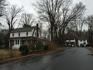
Wilburtha is a section of Ewing Township in Mercer County, in the U.S. state of New Jersey. Located where Wilburtha Road crosses the Delaware and Raritan Canal, it is one of the oldest settlements in Ewing Township and developed due to the construction of the canal in the early 19th century. The community was known as Greensburg before adopting its current name in 1883. The Yardley–Wilburtha Bridge once connected Wilburtha to Yardley, Pennsylvania on the other side of the Delaware River. The Belvidere Delaware Railroad once passed through the village. Today, Wilburtha is primarily a residential neighborhood consisting of detached, single-family homes, the majority of which were built in the 1950s through the early 1980s. There are still many Georgian and Federal-style homes found in the area.

The Shabakunk Creek is a tributary of the Assunpink Creek in Mercer County, New Jersey, United States. Via the Assunpink, its water ultimately flows into the Delaware River. The name Shabakunk is from the Lenape word meaning "shore land".

Bear Tavern is an unincorporated community located within Hopewell Township in Mercer County, in the U.S. state of New Jersey.

Ewing is a section of Ewing Township in Mercer County, in the U.S. state of New Jersey. Located at the intersection of Upper Ferry Road and Scotch Road, it is one of the oldest settlements in Ewing Township and dates back to the 18th century. The community was known as Carleton before adopting its current name.
Butler Pike is a road in Montgomery County, Pennsylvania, that runs northeast from Conshohocken to Horsham Township. For most of its 9.8-mile (15.8 km) length, it is a county road and forms a boundary between townships.

The Old Ryan Farm, also known as the Benjamin Temple House and the Temple–Ryan Farmhouse, is a historic house built c. 1750 and located at 27 Federal City Road in the Ewingville section of Ewing Township in Mercer County, New Jersey, United States. It was added to the National Register of Historic Places on September 10, 1971, for its significance in agriculture and architecture. The house was moved from its original location on Pennington Road in May 1973. The Benjamin Temple House is now operated as a historic house museum by the Ewing Township Historic Preservation Society.


