Somerset, New Jersey | |
---|---|
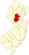
Location in Somerset County Location in New Jersey | |
Coordinates: 40°30′31″N74°30′01″W / 40.508507°N 74.500207°W | |
Country | United States |
State | New Jersey |
County | Somerset |
Township | Franklin |
Area | |
• Total | 6.46 sq mi (16.74 km2) |
• Land | 6.33 sq mi (16.39 km2) |
• Water | 0.13 sq mi (0.35 km2) 1.82% |
Elevation | 118 ft (36 m) |
Population | |
• Total | 22,968 |
• Density | 3,629.01/sq mi (1,401.11/km2) |
Time zone | UTC−05:00 (Eastern (EST)) |
• Summer (DST) | UTC−04:00 (Eastern (EDT)) |
ZIP Codes | 08873, 08875 [4] |
Area code(s) | 732/848 |
FIPS code | 34-68370 [5] [6] [7] |
GNIS feature ID | 02390312 [5] [8] [9] |
Somerset is an unincorporated community and census-designated place (CDP) located within Franklin Township, in Somerset County, in the U.S. state of New Jersey. [10] [11] [12] [13] As of the 2010 United States Census, the CDP's population was 22,083. [14]
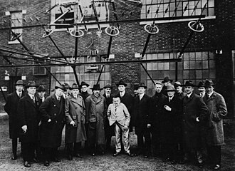
Somerset housed one of the first Marconi Wireless Stations in the United States. [15] [16]
New Brunswick Marconi Station was located at JFK Boulevard and Easton Avenue just a few minutes from the New Brunswick border. Today it is the site of Marconi Park. It was an early radio transmitter facility built in 1913 and operated by the Marconi Wireless Telegraph Company of America. After the interruption of transatlantic telegraph cables by enemy action, the facility was confiscated by the United States Navy on April 7, 1917, [17] to provide transatlantic communications during World War I. The New Brunswick Naval Radio Station was the principal wartime communication link between the United States and Europe, using the callsign NFF. President Woodrow Wilson's Fourteen Points speech was transmitted from the site in 1918. After the war, ownership of the station, along with Marconi's other US assets, was transferred from the navy to RCA. [18] The antenna masts were demolished in 1952 to make room for what is now a small mall containing a Kmart, but the buildings on the other side of JFK Boulevard were spared. All but one of the brick buildings were demolished around 2004 to make way for a storage locker facility. The bricks and tiles were saved for use in any future restoration of the spared building, and the Marconi facility in Belmar, New Jersey.
During World War I, the original Marconi spark-gap transmitter was replaced with an Alexanderson alternator, the invention of the famous General Electric engineer, with an output power of 200 kilowatts and looking like an ordinary power station generator. Its frequency was around 17 kHz, which made its wavelength around 17,500 meters. The station used a huge 5,000-foot-long (1,500 m) antenna supported by eight 400-foot (120 m) tall steel masts, similar to the AT&T long wave telephone transmitter at RCA's Rocky Point, Long Island, transmitter facility.
According to the United States Census Bureau, the CDP had a total area of 6.444 square miles (16.692 km2), including 6.327 square miles (16.388 km2) of land and 0.117 square miles (0.304 km2) of water (1.82%). [5] [19]
The climate in the area is characterized by hot, humid summers and generally cool to cold winters. According to the Köppen climate classification system, Somerset has a humid continental climate, abbreviated "Dfa" on climate maps. [20]
Census | Pop. | Note | %± |
---|---|---|---|
1980 | 21,731 | — | |
1990 | 22,070 | 1.6% | |
2000 | 23,040 | 4.4% | |
2010 | 22,083 | −4.2% | |
2020 | 22,968 | 4.0% | |
Population sources: 1980 [21] 1990–2010 [12] 2000 [22] 2010 [14] [3] |
The 2010 United States census counted 22,083 people, 8,594 households, and 5,552 families in the CDP. The population density was 3,490.1 per square mile (1,347.5/km2). There were 8,883 housing units at an average density of 1,403.9 per square mile (542.0/km2). The racial makeup was 47.04% (10,387) White, 28.88% (6,378) Black or African American, 0.23% (50) Native American, 17.59% (3,885) Asian, 0.01% (3) Pacific Islander, 2.98% (659) from other races, and 3.26% (721) from two or more races. Hispanic or Latino of any race were 9.47% (2,092) of the population. [14]
Of the 8,594 households, 27.7% had children under the age of 18; 51.1% were married couples living together; 9.9% had a female householder with no husband present and 35.4% were non-families. Of all households, 29.0% were made up of individuals and 9.9% had someone living alone who was 65 years of age or older. The average household size was 2.50 and the average family size was 3.14. [14]
20.3% of the population were under the age of 18, 6.6% from 18 to 24, 30.4% from 25 to 44, 27.5% from 45 to 64, and 15.1% who were 65 years of age or older. The median age was 39.8 years. For every 100 females, the population had 91.4 males. For every 100 females ages 18 and older there were 87.2 males. [14]
At the 2000 United States Census [6] there were 23,040 people, 8,238 households and 5,799 families residing in the CDP. The population density was 4,322.7 inhabitants per square mile (1,669.0/km2). There were 8,424 housing units at an average density of 1,580.5 per square mile (610.2/km2). The racial makeup of the CDP was 43.94% White, 38.55% African American, 0.26% Native American, 8.23% Asian, 0.05% Pacific Islander, 6.04% from other races, and 2.94% from two or more races. Hispanic or Latino of any race were 12.00% of the population. [22]
There were 8,238 households, of which 31.2% had children under the age of 18 living with them, 52.6% were married couples living together, 12.9% had a female householder with no husband present, and 29.6% were non-families. 22.8% of all households were made up of individuals, and 6.8% had someone living alone who was 65 years of age or older. The average household size was 2.78 and the average family size was 3.29. [22]
24.0% of the population were under the age of 18, 8.7% from 18 to 24, 32.6% from 25 to 44, 23.3% from 45 to 64, and 11.4% who were 65 years of age or older. The median age was 36 years. For every 100 females, there were 94.3 males. For every 100 females age 18 and over, there were 91.9 males. [22]
The median household income was $65,831 and the median family income was $73,040. Males had a median income of $50,309 versus $36,162 for females. The per capita income for the CDP was $26,798. About 4.9% of families and 7.0% of the population were below the poverty line, including 9.9% of those under age 18 and 4.3% of those age 65 or over. [22]
SHI International and Catalent are headquartered in Somerset.
PIM Brands (Division of The Promotion In Motion Companies and Makers of Welch's Fruit Snacks) operates a manufacturing plant in Somerset.
Meda Pharmaceuticals' U.S. home office is located in Somerset.
Based on 2011 data from the United States Census Bureau, The Washington Post named Somerset County as having sixth-highest median household income of any county in the United States. [23]
People who were born in, residents of, or otherwise closely associated with Somerset include:
Glendora is an unincorporated community and census-designated place (CDP) located within Gloucester Township, in Camden County, in the U.S. state of New Jersey. As of the 2010 United States Census, the CDP's population was 4,750.
Cedarville is an unincorporated community and census-designated place (CDP) located within Lawrence Township, in Cumberland County, in the U.S. state of New Jersey. It is part of the Vineland-Millville-Bridgeton Primary Metropolitan Statistical Area for statistical purposes. As of the 2020 United States census, the CDP's population was 702.
Avenel is an unincorporated community and census-designated place (CDP) located within Woodbridge Township, in Middlesex County, in the U.S. state of New Jersey. Avenel is approximately 25 miles (40 km) southwest of Midtown Manhattan along the North Jersey Coast rail line
Iselin is an unincorporated community and census-designated place (CDP) located within Woodbridge Township, in Middlesex County, in the U.S. state of New Jersey. As of the 2020 United States census, Iselin's population was 20,088, up from 18,695 in 2010.
Kendall Park is an unincorporated community and census-designated place (CDP) in South Brunswick Township, Middlesex County, New Jersey, United States. As of the 2020 census, the CDP's population was 9,989, up from 9,339 in 2010. Kendall Park has a post office with its own ZIP Code (08824) that encompasses the majority of the CDP, as well as some surrounding areas.
Kingston is an unincorporated community and census designated place (CDP) along the border of South Brunswick Township in Middlesex County and Franklin Township in Somerset County, and also located relatively near Princeton in Mercer County in the U.S. state of New Jersey. The historic settlement is in the Raritan Valley region, located along the course of the Millstone River. As of the 2020 census, the CDP's population was 1,581, of which 1,272 were in South Brunswick Township and 309 in Franklin Township.
Morganville is an unincorporated community and census-designated place (CDP) within Marlboro Township, in Monmouth County, New Jersey, United States. As of the 2020 census, the CDP's population was 6,203, up from 5,040 in 2010.
Wanamassa is an unincorporated community and census-designated place (CDP) within Ocean Township, in Monmouth County, New Jersey, United States. As of the 2020 census, the CDP's population was 4,344. The community was named for Wanamassa, a Native American leader of the 17th century.
Franklin Township is a township in Somerset County, in the U.S. state of New Jersey. It is centrally located in the Raritan Valley region, within the New York Metropolitan Area. As of the 2020 United States census, the township's population was 68,364, an increase of 6,064 (+9.7%) from the 2010 census count of 62,300, which in turn reflected an increase of 11,397 (+22.4%) from the 50,903 counted in the 2000 census. The township was the state's 19th most-populous municipality in 2020, after being ranked 22nd in 2010.
Griggstown is an unincorporated community and census-designated place (CDP) located within Franklin Township, in Somerset County, in the U.S. state of New Jersey. As of the 2010 United States Census, the CDP's population was 819. The area was first settled around 1733. The Millstone River and the Delaware and Raritan Canal both flow through Griggstown.
Middlebush is an unincorporated community and census-designated place (CDP) located in Franklin Township, in Somerset County, in the U.S. state of New Jersey. As of the 2010 United States Census, the CDP's population was 2,326. It is perhaps most distinguished as being the host section for Franklin Township's municipal complex.
Blawenburg is an unincorporated community and census-designated place (CDP) located within Montgomery Township, in Somerset County, in the U.S. state of New Jersey. As of the 2010 United States Census, the CDP's population was 280. It is located at the juncture of two large roads, CR 518 and CR 601.
East Millstone is an unincorporated community and census-designated place (CDP) located in Franklin Township in Somerset County, in the U.S. state of New Jersey.
Skillman is an unincorporated community and census-designated place (CDP) located within Montgomery Township, in Somerset County, in the U.S. state of New Jersey. As of the 2010 United States Census, the CDP's population was 242.
Franklin Park is an unincorporated community and census-designated place (CDP) located within Franklin Township, in Somerset County, in the U.S. state of New Jersey. As of the 2010 United States Census, the CDP's population was 13,295. Route 27 bisects the village and serves as the dividing line between the two counties. The adjacent sections of South Brunswick and North Brunswick, Middlesex County on the east side of Route 27 are also known as Franklin Park, but are not included within the CDP's boundaries.
Pleasant Plains is an unincorporated community and census-designated place (CDP) located in Franklin Township, in Somerset County, in the U.S. state of New Jersey. As of the 2010 United States Census, the CDP's population was 922. Having no distinct boundaries, a large area in the center of Franklin Township centered on the intersections of South Middlebush Road with Claremont and Suydam Roads is generally considered Pleasant Plains.
Weston is an unincorporated community and census-designated place (CDP) located in Franklin Township, in Somerset County, in the U.S. state of New Jersey. As of the 2010 United States Census, the CDP's population was 1,235.
Clyde is an unincorporated community and census-designated place (CDP) located in Franklin Township, in Somerset County, in the U.S. state of New Jersey. It was a station stop on the Penna RR's Millstone Branch. As of the 2010 United States Census, the CDP's population was 213.
East Franklin is an unincorporated community and census-designated place (CDP) located in Franklin Township, in Somerset County, in the U.S. state of New Jersey. At the 2010 United States Census, East Franklin's population was 8,669.
Franklin Center is an unincorporated community and census-designated place (CDP) located in Franklin Township, in Somerset County, in the U.S. state of New Jersey. As of the 2010 United States Census, the CDP's population was 4,460.