
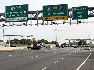
Route 27 is a state highway in New Jersey, United States. It runs 38.53 mi (62.01 km) from U.S. Route 206 (US 206) in Princeton, Mercer County northeast to an interchange with Route 21 and Broad Street in Newark, Essex County. The route passes through many communities along the way, including New Brunswick, Highland Park, Edison, Metuchen, Rahway, and Elizabeth. Route 27 is a two- to four-lane undivided highway for most of its length, passing through a variety of urban and suburban environments. It intersects many roads along the way, including Route 18 in New Brunswick, Interstate 287 (I-287) in Edison, the Garden State Parkway in Woodbridge Township, Route 35 in Rahway, Route 28 in Elizabeth, and U.S. Route 22 in Newark. Route 27 crosses the Raritan River on the Albany Street Bridge, which connects Highland Park on the east with New Brunswick on the west.

Middlesex County is a county located in the north-central part of the U.S. state of New Jersey, extending inland from the Raritan Valley region to the northern portion of the Jersey Shore. As of the 2020 United States census, the county was the state's third-most populous county with a population of 863,162, its highest decennial count ever and an increase of 53,304 (+6.6%) from the 2010 census count of 809,858, which in turn reflected an increase of 59,696 (8.0%) from the 750,162 counted in the 2000 census. Middlesex is part of the New York metropolitan area. Many communities within the county serve as commuter towns to and from New York City and other points north. The county is part of the Central Jersey region of the state.

Ewing Township is a township in Mercer County, in the U.S. state of New Jersey. The township falls within the New York metropolitan area as defined by the U.S. Census Bureau. It borders the Philadelphia metropolitan area and is part of the Federal Communications Commission's Philadelphia Designated Market Area. As of the 2020 United States census, the township's population was 37,264, its highest decennial count ever and an increase of 1,474 (+4.1%) from the 35,790 recorded at the 2010 census, which in turn reflected an increase of 83 (+0.2%) from the 35,707 counted in the 2000 census.
East Brunswick is a township in Middlesex County, in the U.S. state of New Jersey. The suburban bedroom community is part of the New York City metropolitan area and is located on the southern shore of the Raritan River, directly adjacent to the city of New Brunswick and located roughly 29 miles (47 km) away from New York City. As of the 2020 United States census, the township's population was 49,715, its highest decennial count ever and an increase of 2,203 (+4.6%) from the 2010 census count of 47,512, which in turn reflected an increase of 756 (+1.6%) from the 46,756 counted in the 2000 census.

Milltown is a borough in Middlesex County, in the U.S. state of New Jersey. The borough is nestled within the heart of the Raritan Valley region, with Lawrence Brook flowing through the center of the community. As of the 2020 United States census, the borough's population was 7,037, an increase of 144 (+2.1%) from the 2010 census count of 6,893, which in turn reflected a decrease of 107 (−1.5%) from the 7,000 counted in the 2000 census.

Route 88 is a state highway in the northern part of Ocean County, New Jersey, United States. It runs 10.02 mi (16.13 km) from an intersection with U.S. Route 9 and County Route 547 in Lakewood Township to an intersection with Route 35 in Point Pleasant. It is a two-lane undivided road that passes through mostly residential and commercial areas. The route intersects CR 549 in Lakewood, Route 70 in Brick Township at the former Laurelton Circle, and CR 549 Spur in Point Pleasant. The road is mentioned in the lyrics of the 1973 song "Spirit in the Night" by Bruce Springsteen.

North Brunswick is a township in Middlesex County, in the U.S. state of New Jersey. It is centrally located in the Raritan Valley region within the New York metropolitan area. As of the 2020 United States census, the township's population was 43,905, an increase of 3,163 (+7.8%) from the 2010 census count of 40,742, which in turn reflected an increase of 3,455 (+12.3%) from the 36,287 counted in the 2000 census.

Route 171 is a state highway in New Jersey, United States. It runs just under one mile (1.6 km) as an extension of U.S. Route 130 (US 130) past its northern terminus at US 1 in North Brunswick Township. The state highway ends along Georges Road near the border of North Brunswick Township and the city of New Brunswick. The route formerly extended into downtown New Brunswick ending at an intersection with Route 27, though the route was mostly unsigned inside New Brunswick. The route is a major thoroughfare in North Brunswick. The route originated as an alignment of pre-1927 Route 1 and later of US 130. After US 130 was truncated, the alignment, which had also been designated Route 25M, was later re-designated as Route 171.

Central Jersey, or Central New Jersey, is the middle region of the U.S. state of New Jersey. The designation Central Jersey is a distinct administrative toponym. While New Jersey is often divided into North Jersey and South Jersey, many residents recognize Central Jersey as a distinct third entity. As of the 2020 census, Central Jersey has a population of 3,580,999.

U.S. Route 1 Business is a four-lane surface road that provides an alternate route to the Trenton Freeway (US 1) northeast of Trenton in Mercer County, New Jersey. The route is 2.73 miles (4.39 km) long and runs between US 1 in Trenton and Lawrence Township. On the border of Trenton and Lawrence Township, US 1 Bus. intersects the northbound direction of US 206 at the Brunswick Circle. The route was once part of a longer U.S. Route 1 Alternate, which continued southwest through downtown Trenton and into Morrisville, Pennsylvania.
Deans is an unincorporated community and census-designated place (CDP) in South Brunswick Township, Middlesex County, New Jersey, in the United States. As of the 2020 United States census, Deans had a population of 1,615.

County Route 518 is a county highway in the U.S. state of New Jersey. The highway extends 20.58 miles (33.12 km) from Route 29/Route 165 in Lambertville to Lincoln Highway in Franklin Township. It is also known as the Georgetown Franklin Turnpike.
U.S. Route 1 (US 1) is a U.S. Route which parallels the East Coast of the United States, running from Key West, Florida, in the south to Fort Kent, Maine, at the Canadian border in the north. Of the entire length of the route, 66.06 miles (106.31 km) of it runs through New Jersey. It enters the state from Pennsylvania on the Trenton–Morrisville Toll Bridge over the Delaware River in the state capital of Trenton, running through the city on the Trenton Freeway. From here, US 1 continues northeast as a surface divided highway through suburban areas, heading into Middlesex County and passing through New Brunswick and Edison. US 1 merges with US 9 in Woodbridge, and the two routes continue through northern New Jersey as US 1/9 to the George Washington Bridge over the Hudson River in Fort Lee. At this point, the road continues into New York City along with I-95.

Prospertown is an unincorporated community located within the New Jersey townships of Jackson and Plumsted in Ocean County and Upper Freehold in Monmouth County. The community is home to Prospertown Lake and is adjacent to Six Flags Great Adventure, both located on County Route 537. The center of the community is located at the intersection of CR 537, Hawkin Road, and Emleys Hill Road. Most of the area consists of pine forests but there are some homes along the roads in the area.

Ten Mile Run is an unincorporated community and census-designated place (CDP) located in Franklin Township, in Somerset County, in the U.S. state of New Jersey. As of the 2010 United States Census, the CDP's population was 1,959.

Penns Neck is an unincorporated community located within West Windsor Township in Mercer County, in the U.S. state of New Jersey. The community developed at the intersection of the Trenton-New Brunswick Turnpike and Washington Road. The Penns Neck Circle and the historic Penns Neck Baptist Church (1812) are both located in Penns Neck. The Princeton Branch rail line, known as the Dinky, has run through the area since 1865, and stopped at Penns Neck station until January 1971.

Little Rocky Hill is an unincorporated community located within South Brunswick in Middlesex County and Franklin Township, Somerset County, in the U.S. state of New Jersey. The community is located atop a small hill east of the borough of Rocky Hill. The Middlesex–Somerset county line runs through the community along Old Road though elsewhere it follows Route 27. Carters Brook runs through the area flowing south.
Sand Hills is an unincorporated community located within South Brunswick Township in Middlesex County, in the U.S. state of New Jersey. The settlement is named for Sand Hills, a small group of diabase hills which contains Middlesex County's highest point. The settlement is located approximately at the intersection of U.S. Route 1, Sand Hills Road, and Major Road. There is a small cluster of houses and small businesses on Major Road just south of US 1 while more housing developments are found on the north side of the highway. Fast food restaurants, stores, and repair shops line US 1 through the area; this area of US 1 also has large inclines on both sides of the hills to climb from the relatively low and flat areas of the Atlantic coastal plain.

Freewood Acres is an unincorporated community located within Howell Township in Monmouth County, in the U.S. state of New Jersey. The area is made up of mostly single-story homes arranged along a street grid in the northern reaches of the Pine Barrens. U.S. Route 9 runs through the center of the community just north of its interchange with Interstate 195. The Land O'Pines Elementary School and Manasquan Reservoir County Park exist to the east of the community. It became the center of the Kalmyk American community in the latter part of the 20th century.


