Deans, New Jersey

Last updated
Deans, New Jersey
Deans, NJ.jpg
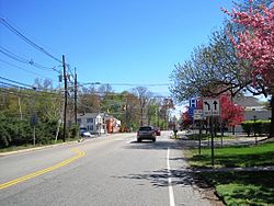
Center of Deans at Georges Road and Deans Lane
Location map of Middlesex County, New Jersey.svg
Red pog.svg
Deans, New Jersey
Location of Deans in Middlesex County Inset: Location of county within the state of New Jersey
USA New Jersey location map.svg
Red pog.svg
Deans, New Jersey
Deans, New Jersey (New Jersey)
Usa edcp location map.svg
Red pog.svg
Deans, New Jersey
Deans, New Jersey (the United States)
Coordinates: 40°24′15″N74°30′58″W / 40.40417°N 74.51611°W / 40.40417; -74.51611 Coordinates: 40°24′15″N74°30′58″W / 40.40417°N 74.51611°W / 40.40417; -74.51611
Country Flag of the United States.svg  United States
State Flag of New Jersey.svg  New Jersey
County Middlesex
Township South Brunswick
Area
[1]
  Total1.13 sq mi (2.93 km2)
  Land1.12 sq mi (2.90 km2)
  Water0.01 sq mi (0.03 km2)
Elevation
[2]
85 ft (26 m)
Population
 (2020) [3]
  Total1,615
  Density1,440.68/sq mi (556.36/km2)
ZIP code
08852
GNIS feature ID875833 [2]

Deans is an unincorporated community located within South Brunswick Township in Middlesex County, New Jersey, United States. [4]

Deans originated from its location on both Crosswicknung Trail (Georges Road) and Lawrence Brook. Dams were built on the brook, creating Deans Pond. The center of the community is centered about the intersection of Deans Lane (County Route 610) and Georges Road (CR 697). CR 610 continues east from the community on Deans Rhode Hall Road; other transportation facilities that pass near Deans include U.S. Route 130 just east of the community and the Northeast Corridor railroad to the west (a station serving the community once existed [5] ). Residential homes dot the area around Deans but some businesses line nearby arterial roads and large warehouses are situated along Industrial Way at US 130. [6]

Demographics

Historical population
CensusPop.
2020 1,615
U.S. Decennial Census [7]

Related Research Articles

<span class="mw-page-title-main">New Jersey Route 59</span> Highway in New Jersey

Route 59, at 0.15-mile (0.24 km) long, is the shortest state highway in New Jersey, United States. The route consists entirely of a short block of Lincoln Avenue from Union County Route 610 in Cranford to New Jersey Route 28 along the Cranford–Garwood border. The route functions as an underpass under the Raritan Valley Line of NJ Transit, under which it crosses about halfway down the block, along the municipal border. Route 59 was originally a proposed alignment of Route 22, which was supposed to head from an intersection with current day New Jersey Route 159 in Morris County at the Pine Brook Bridge before heading through several counties, terminating at an intersection with New Jersey Route 27 in Rahway. Most of the route was not constructed, and a portion in Garwood and Cranford was re-designated Route 59 in the 1953 New Jersey state highway renumbering on January 1, 1953.

<span class="mw-page-title-main">Middlesex County, New Jersey</span> County in New Jersey, United States

Middlesex County is located in central New Jersey, United States, extending inland from the Raritan Valley region to the northern portion of the Jersey Shore. As of the 2020 United States Census, the county's population was enumerated at 863,162, making Middlesex the state's third-most populous county. Middlesex County's population in 2020 represented a growth of 53,304 (6.6%) from the 809,858 residents counted at the 2010 census. Middlesex County is part of the New York metropolitan area and many communities within the county serve as commuter towns to and from New York City and other points north.

<span class="mw-page-title-main">South Brunswick, New Jersey</span> Township in Middlesex County, New Jersey, United States

South Brunswick is a township in Middlesex County, New Jersey, United States. The township is centrally located within the Raritan Valley region and is an outer-ring suburb of New York City in the New York metropolitan area. As of the 2020 United States Census, the township's population was 47,043, reflecting an increase of 3,626 (+8.4%) from the 43,417 counted in the 2010 Census.

<span class="mw-page-title-main">West Freehold, New Jersey</span> Census-designated place in New Jersey, United States

West Freehold is an unincorporated community and census-designated place (CDP) within Freehold Township, in Monmouth County, New Jersey, United States. As of the 2010 United States Census, the CDP's population was 13,613. Due to the community's close proximity to the Battle of Monmouth, West Freehold is home to several important historical structures, which have been preserved in the 'West Freehold Village Historic District'. The historically preserved Monmouth Battlefield, along with the historic villages of Clarksburg, Englishtown, Smithburg and Tennent are a short distance away.

<span class="mw-page-title-main">Franklin Township, Somerset County, New Jersey</span> Township in Somerset County, New Jersey, United States

Franklin Township is a township in Somerset County, New Jersey, United States. It is centrally located in the Raritan Valley region, within the New York Metropolitan Area. As of the 2010 United States Census, the township's population was 62,300, reflecting an increase of 11,397 (+22.4%) from the 50,903 counted in the 2000 Census, which had in turn increased by 8,123 (+19.0%) from the 42,780 counted in the 1990 Census.

<span class="mw-page-title-main">New Jersey Route 73</span> Highway in New Jersey

Route 73 is a state highway in the southern part of the U.S. state of New Jersey. It runs 34.64 mi (55.75 km) as an outer bypass of the Camden area from an intersection with U.S. Route 322 (US 322) in Folsom, Atlantic County to the Tacony–Palmyra Bridge in Palmyra, Burlington County, where it continues into Philadelphia, Pennsylvania as Pennsylvania Route 73. South of the interchange with the Atlantic City Expressway in Winslow Township, Camden County, Route 73 is a two-lane undivided county-maintained road and is signed as County Route 561 Spur, a spur of CR 561. North of the Atlantic City Expressway, the route is maintained by the New Jersey Department of Transportation and is mostly four lanes, with the portion north of the CR 561 concurrency a divided highway. North of the US 30 interchange near Berlin, Route 73 runs through suburban areas of the Delaware Valley, intersecting Route 70 in Marlton, the New Jersey Turnpike and Interstate 295 (I-295) in Mount Laurel Township, Route 38 and Route 41 in Maple Shade Township, Route 90 in Cinnaminson Township, and US 130 in Pennsauken Township.

<span class="mw-page-title-main">U.S. Route 130</span> Highway in New Jersey

U.S. Route 130 is a U.S. Highway that is a spur route of U.S. Route 30, located completely within the state of New Jersey. It is signed with north and south cardinal directions, following a general northeast–southwest diagonal path, with "north" corresponding to the general eastward direction and vice versa. The route runs 83.46 mi (134.32 km) from Interstate 295 (I-295) and US 40 at Deepwater in Pennsville Township, Salem County, where the road continues south as Route 49, north to US 1 in North Brunswick Township, Middlesex County, where Route 171 continues north into New Brunswick. The route briefly runs concurrent with US 30 near Camden, about one-third of the way to New Brunswick. The road runs within a close distance of I-295 south of Bordentown and a few miles from the New Jersey Turnpike for its entire length, serving as a major four- to six-lane divided local road for most of its length. US 130 passes through many towns including Penns Grove, Bridgeport, Westville, Camden, Pennsauken, Burlington, Bordentown, Hightstown, and North Brunswick.

<span class="mw-page-title-main">U.S. Route 206</span> Highway in New Jersey and Pennsylvania

U.S. Route 206 is a 130.23-mile-long (209.58 km) north–south United States highway in New Jersey and Pennsylvania, United States. Only about a half a mile of its length is in Pennsylvania; the Milford–Montague Toll Bridge carries it over the Delaware River into New Jersey, where the remainder of the route is. Its southern terminus is in Hammonton, New Jersey, at an intersection with US 30 and Route 54. The highway's northern terminus is near Milford, Pennsylvania at an intersection with US 209; some sources and signs show an overlap with US 209 to end at its parent route US 6. For much of its length, US 206 is a rural two-lane undivided road that passes through the Pine Barrens, agricultural areas, and the Appalachian Mountains of northwestern New Jersey, with some urban and suburban areas. The route connects several cities and towns, including Bordentown, Trenton, Princeton, Somerville, Roxbury, Netcong, and Newton. The road is known as the Disabled American Veterans Highway for much of its length.

<span class="mw-page-title-main">North Brunswick, New Jersey</span> Township in Middlesex County, New Jersey, United States

North Brunswick is a township in Middlesex County, New Jersey, United States. It is centrally located in the Raritan Valley region within the New York Metropolitan area. At the 2020 United States Census, the population was 43,905, reflecting an increase of (+7.5%) from the 40,742 counted in the 2010 Census, which had in turn increased by 3,455 (+12.3%) from the 36,287 counted in the 2000 Census. Located south of the city of New Brunswick, North Brunswick was named for its earlier-established neighbor, South Brunswick, New Jersey. The "Brunswick" comes from New Brunswick, which was named after the German city of Braunschweig or for the British royal House of Brunswick. North and South Brunswick, in turn, became the namesakes for East Brunswick. Alternatively, the city gets its name from King George II of Great Britain, the Duke of Brunswick-Lüneburg.

<span class="mw-page-title-main">U.S. Route 46</span> Highway in New Jersey

U.S. Route 46 (US 46) is an east–west U.S. Highway completely within the state of New Jersey, running for 75.34 mi (121.25 km), making it the shortest signed, non-spur U.S. Highway. The west end is at an interchange with Interstate 80 (I-80) and Route 94 in Columbia, Warren County on the Delaware River. The east end is in the middle of the George Washington Bridge over the Hudson River in Fort Lee, Bergen County while the route is concurrent with I-95 and US 1-9. Throughout much of its length, US 46 is closely paralleled by I-80. US 46 is a major local and suburban route, with some sections built to or near freeway standards and many other sections arterials with jughandles. The route runs through several communities in the northern part of New Jersey, including Hackettstown, Netcong, Dover, Parsippany-Troy Hills, Wayne, Clifton, Ridgefield Park, Palisades Park, and Fort Lee. It crosses over the Upper Passaic River at several points. The road has been ceremonially named the United Spanish–American War Veterans Memorial Highway.

<span class="mw-page-title-main">New Jersey Route 171</span> State highway in Middlesex County, New Jersey, United States

Route 171 is a state highway in New Jersey, United States. It runs just under one mile (1.6 km) as an extension of U.S. Route 130 (US 130) past its northern terminus at US 1 in North Brunswick Township. The state highway ends along Georges Road near the border of North Brunswick Township and the city of New Brunswick. The route formerly extended into downtown New Brunswick ending at an intersection with Route 27, though the route was mostly unsigned inside New Brunswick. The route is a major thoroughfare in North Brunswick. The route originated as an alignment of pre-1927 Route 1 and later of US 130. After US 130 was truncated, the alignment, which had also been designated Route 25M, was later re-designated as Route 171.

<span class="mw-page-title-main">County Route 561 (New Jersey)</span>

County Route 561 is a county highway in the U.S. state of New Jersey. The highway extends 50.95 miles (82.00 km) from New York Road in Galloway Township to Federal Street in Camden.

<span class="mw-page-title-main">County Route 553 (New Jersey)</span>

County Route 553 is a county highway in the U.S. state of New Jersey. The highway extends 51.22 miles (82.43 km) from Hands Landing Road/Ogden Avenue in Commercial Township to Broadway in Deptford Township.

<span class="mw-page-title-main">County Route 536 (New Jersey)</span>

County Route 536 is a county highway in the U.S. state of New Jersey. The highway extends 39 miles (63 km) from the Commodore Barry Bridge crossing the Delaware River at Chester at the Pennsylvania state line and Logan Township, to U.S. Route 206 (US 206) in Hammonton. Much of the western portion of the route is concurrent with US 322 though it is unsigned along this portion.

<span class="mw-page-title-main">U.S. Route 1 in New Jersey</span> Highway in New Jersey

U.S. Route 1 is a United States highway which parallels the East Coast of the United States, running from Key West, Florida in the south to Fort Kent, Maine at the Canadian border in the north. Of the entire length of the route, 66.06 miles (106.31 km) of it runs through New Jersey. It enters the state from Pennsylvania on the Trenton–Morrisville Toll Bridge over the Delaware River in the state capital of Trenton, running through the city on the Trenton Freeway. From here, US 1 continues northeast as a surface divided highway through suburban areas continuing into Middlesex County and passing through New Brunswick and Edison. US 1 merges with US 9 in Woodbridge, and the two routes continue through northern New Jersey as US 1/9 to the George Washington Bridge over the Hudson River in Fort Lee. At this point, the road continues into New York City along with I-95.

<span class="mw-page-title-main">Mercerville, New Jersey</span> Census-designated place in New Jersey, United States

Mercerville is an unincorporated community and census-designated place (CDP) located within Hamilton Township, in Mercer County, New Jersey, United States. As of the 2010 United States Census, the CDP's population was 13,230. Until after the 2000 Census, the area was part of the Mercerville-Hamilton Square CDP. For the 2010 Census it was split into two CDPs, Mercerville and Hamilton Square.

<span class="mw-page-title-main">New Monmouth, New Jersey</span> Unincorporated community in New Jersey, United States

New Monmouth is an unincorporated community located within Middletown Township in Monmouth County, New Jersey, United States. The area is served as United States Postal Service ZIP code 07748.

<span class="mw-page-title-main">Jobstown, New Jersey</span> Unincorporated community in New Jersey, United States

Jobstown is an unincorporated community located within Springfield Township in Burlington County, New Jersey, United States. The area is served as United States Postal Service ZIP code 08041.

<span class="mw-page-title-main">New Lisbon, New Jersey</span> Unincorporated community in New Jersey, United States

New Lisbon is an unincorporated community located within Pemberton Township in Burlington County, New Jersey, United States. It is a settlement along Four Mile Road where it intersects Mount Misery Road. The community is located along the Philadelphia and Long Branch Railway, later a part of the Pennsylvania Railroad, and featured a train station.

Othello is an unincorporated community and census-designated place located within Greenwich Township, Cumberland County, New Jersey, United States. It was first listed as a CDP in the 2020 census with a population of 132.

References

  1. "ArcGIS REST Services Directory". United States Census Bureau. Retrieved October 11, 2022.
  2. 1 2 "Deans". Geographic Names Information System . United States Geological Survey, United States Department of the Interior.
  3. "Census Population API". United States Census Bureau. Retrieved Oct 11, 2022.
  4. Locality Search, State of New Jersey. Accessed February 7, 2015.
  5. Pennsylvania Railroad and Its Connections (Map). December 1, 1911. Retrieved January 17, 2015.
  6. Google (May 17, 2015). "Aerial view of Deans" (Map). Google Maps . Google. Retrieved May 17, 2015.
  7. "Census of Population and Housing". Census.gov. Retrieved June 4, 2016.