Related Research Articles

The New Jersey Turnpike (NJTP) is a system of controlled-access toll roads in the U.S. state of New Jersey. The turnpike is maintained by the New Jersey Turnpike Authority (NJTA). The 117.20-mile (188.62 km) mainline's southern terminus is at Interstate 295 (I-295) and U.S. Route 40 (US 40) in Pennsville Township in Salem County, near the Delaware Memorial Bridge. Its northern terminus is at the approach to the George Washington Bridge in Fort Lee in Bergen County; originally it was at an interchange with I-80 and US 46 in Ridgefield Park. Construction of the mainline from concept to completion took 22 months, from 1950 to 1951. It was opened to traffic on November 5, 1951, between its southern terminus and exit 10.

Route 18 is a 42.8-mile-long (68.9 km) state highway in the central part of the US state of New Jersey. It begins at an intersection with Route 138 in Wall Township, Monmouth County and ends at Interstate 287 (I-287) in Piscataway Township, Middlesex County. Route 18 is a major route through central New Jersey that connects the Jersey Shore to the Raritan Valley region, connecting the county seats of Monmouth (Freehold) and Middlesex respectively. The route runs through Ocean Township, Marlboro Township, East Brunswick, and is the main thoroughfare for Rutgers University. Much of the route is a freeway. The remainder of the route is an arterial road with traffic lights in the East Brunswick and Old Bridge areas, and a boulevard in the remainder of Piscataway. Route 18 was designated in 1939 as a proposed freeway from Old Bridge to Eatontown. The section west of Old Bridge was formerly designated as part Route S28, a prefixed spur of State Highway Route 28 from Middlesex to Matawan. The designation, assigned in the 1927 renumbering, remained until a second renumbering in 1953. At that point, Route S28 was redesignated as Route 18, though the section from Old Bridge to Matawan was signed as TEMP 18, as this section would be decommissioned when the Route 18 freeway was built.

Route 27 is a state highway in New Jersey, United States. It runs 38.53 mi (62.01 km) from U.S. Route 206 (US 206) in Princeton, Mercer County northeast to an interchange with Route 21 and Broad Street in Newark, Essex County. The route passes through many communities along the way, including New Brunswick, Highland Park, Edison, Metuchen, Rahway, and Elizabeth. Route 27 is a two- to four-lane undivided highway for most of its length, passing through a variety of urban and suburban environments. It intersects many roads along the way, including Route 18 in New Brunswick, Interstate 287 (I-287) in Edison, the Garden State Parkway in Woodbridge Township, Route 35 in Rahway, Route 28 in Elizabeth, and U.S. Route 22 in Newark. Route 27 crosses the Raritan River on the Albany Street Bridge, which connects Highland Park on the east with New Brunswick on the west.

Middlesex County is located in the north-central part of New Jersey, United States, extending inland from the Raritan Valley region to the northern portion of the Jersey Shore. As of the 2020 United States census, the county was the state's third-most populous county with a population of 863,162, its highest decennial count ever and an increase of 53,304 (+6.6%) from the 2010 census count of 809,858, which in turn reflected an increase of 59,696 (8.0%) from the 750,162 counted in the 2000 census. Middlesex is part of the New York metropolitan area. Many communities within the county serve as commuter towns to and from New York City and other points north. The county is part of the Central Jersey region of the state.
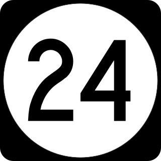
Route 24 is a 10.42-mile (16.77 km) freeway in New Jersey, United States, that begins at a junction with Interstate 287 (I-287) in Hanover Township in Morris County, passes southeast through Essex County, and ends at a junction with I-78 in Springfield Township in Union County.

New Brunswick is a city in and the seat of government of Middlesex County, in the U.S. state of New Jersey. A regional commercial hub for central New Jersey, the city is both a college town and a commuter town for residents commuting to New York City within the New York metropolitan area. New Brunswick is on the Northeast Corridor rail line, 27 miles (43 km) southwest of Manhattan. The city is located on the southern banks of the Raritan River in the heart of the Raritan Valley region.

South Brunswick is a township in Middlesex County, in the U.S. state of New Jersey. The township is centrally located within the Raritan Valley region and is an outer-ring suburb of New York City in the New York metropolitan area. As of the 2020 United States census, the township's population was 47,043, its highest ever decennial census count and an increase of 3,626 (+8.4%) from the 2010 census count of 43,417, which in turn reflected an increase of 5,683 (+15.1%) from the 37,734 counted in the 2000 census.
Franklin Township is a township in Somerset County, in the U.S. state of New Jersey. It is centrally located in the Raritan Valley region, within the New York Metropolitan Area. As of the 2020 United States census, the township's population was 68,364, an increase of 6,064 (+9.7%) from the 2010 census count of 62,300, which in turn reflected an increase of 11,397 (+22.4%) from the 50,903 counted in the 2000 census. The township was the state's 19th most-populous municipality in 2020, after being ranked 22nd in 2010.

Fundy National Park is a national park of Canada located on the Bay of Fundy, near the village of Alma, New Brunswick. It was officially opened on 29 July 1950. The park showcases a rugged coastline which rises up to the Canadian Highlands, the highest tides in the world and more than 25 waterfalls. The park covers an area of 207 km2 (80 sq mi) along Goose Bay, the northwestern branch of the Bay of Fundy. When one looks across the Bay, one can see the northern Nova Scotia coast.

U.S. Route 130 is a U.S. Highway that is a spur route of US 30, located completely within the state of New Jersey. It is signed with north and south cardinal directions, following a general northeast–southwest diagonal path, with north corresponding to the general eastward direction and vice versa. The route runs 83.46 mi (134.32 km) from Interstate 295 (I-295) and US 40 at Deepwater in Pennsville Township, Salem County, where the road continues south as Route 49, north to US 1 in North Brunswick Township, Middlesex County, where Route 171 continues north into New Brunswick. The route briefly runs concurrent with US 30 near Camden, about one-third of the way to New Brunswick. The road runs within a close distance of I-295 south of Bordentown and a few miles from the New Jersey Turnpike for its entire length, serving as a major four- to six-lane divided local road for most of its length. US 130 passes through many towns including Penns Grove, Bridgeport, Westville, Camden, Pennsauken, Burlington, Bordentown, Hightstown, and North Brunswick.

North Brunswick is a township in Middlesex County, in the U.S. state of New Jersey. It is centrally located in the Raritan Valley region within the New York metropolitan area. As of the 2020 United States census, the township's population was 43,905, an increase of 3,163 (+7.8%) from the 2010 census count of 40,742, which in turn reflected an increase of 3,455 (+12.3%) from the 36,287 counted in the 2000 census.

The East Coast Greenway is a 3,000-mile (4,800 km) pedestrian and bicycle route between Maine and Florida along the East Coast of the United States. The nonprofit East Coast Greenway Alliance was created in 1991 with the goal to use the entire route with off-road, shared-use paths; as of 2021, over 1,000 mi (1,600 km) of the route (35%) meets these criteria. In 2020, the Greenway received over 50 million visits.
Joseph V. Egan is an American Democratic Party politician, who represented the 17th Legislative District in the New Jersey General Assembly from 2002 to 2024. He was succeeded in the Assembly by his son, Kevin Egan.

U.S. Route 1 Business is a four-lane surface road that provides an alternate route to the Trenton Freeway (US 1) northeast of Trenton in Mercer County, New Jersey. The route is 2.73 miles (4.39 km) long and runs between US 1 in Trenton and Lawrence Township. On the border of Trenton and Lawrence Township, US 1 Bus. intersects the northbound direction of US 206 at the Brunswick Circle. The route was once part of a longer U.S. Route 1 Alternate, which continued southwest through downtown Trenton and into Morrisville, Pennsylvania.

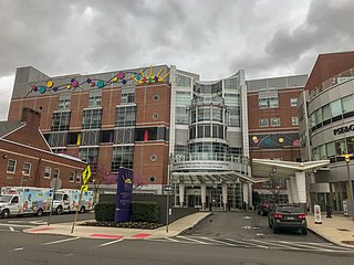
The Robert Wood Johnson University Hospital (RWJUH) is a 965-bed hospital with campuses in New Brunswick, and Somerville, New Jersey, and serves as a flagship hospital of RWJBarnabas Health.
The Bristol-Myers Squibb Children's Hospital at Robert Wood Johnson University Hospital (BMSCH) is a freestanding, 105-bed pediatric acute care children's hospital adjacent to RWJUH. It is affiliated with both Robert Wood Johnson Medical School and the neighboring PSE&G Children's Specialized Hospital, and is one of three children's hospitals in the RWJBarnabas Health network. The hospital provides comprehensive pediatric specialties and subspecialties to infants, children, teens, and young adults aged 0–21 throughout New Jersey and features an ACS verified level II pediatric trauma center. Its regional pediatric intensive-care unit and neonatal intensive care units serve the Central New Jersey region.

Pigeon Swamp State Park is a 1,078-acre (4.36 km2) New Jersey state park located on Deans Rhode Hall Road in South Brunswick, in Middlesex County, New Jersey, United States. It is an undeveloped park, with a mix of habitats including open ponds and uplands hardwood forests. It also includes a good example of an inner coastal plain lowland deciduous hardwood forest. At one time, it was a major nesting site for passenger pigeons before they became extinct. It was declared a National Natural Landmark in December 1976.
The Union Transportation Trail is a 9-mile (14 km) rail trail situated in western Monmouth County, New Jersey. It extends from Hornerstown, New Jersey, to the Assunpink Wildlife Management Area.

East Jersey Old Town Village is an open-air museum located in Johnson Park in Piscataway, New Jersey. The Village is a collection of Raritan Valley area historic buildings and includes original, reconstructed, and replicated 18th and 19th century vernacular architecture typical of farm and merchant communities of Central Jersey. It is home to a permanent exhibition about Raritan Landing, an 18th-century inland port once located just downstream on the river. Since 1989, the Middlesex County Office of Arts and History has had responsibility for the village.
The Assunpink Trail was a Native American trail in what later became Middlesex, Somerset, and Mercer counties in the central and western part of New Jersey. Like Assunpink Creek, the trail takes its name from the Algonquian language Ahsën'pink, meaning "stony, watery place".
References
- ↑ "A Brief History of Dayton". Archived from the original on 2016-03-04.
- ↑ "Township of South Brunswick Environmental Resource Inventory of 2007" (PDF). Archived from the original (PDF) on 2015-03-15. Retrieved 2015-04-05.