Cranbury, New Jersey | |
---|---|
Coordinates: 40°18′48″N74°31′13″W / 40.313448°N 74.520224°W | |
Country | United States |
State | New Jersey |
County | Middlesex |
Township | Cranbury |
Area | |
• Total | 1.24 sq mi (3.22 km2) |
• Land | 1.22 sq mi (3.17 km2) |
• Water | 0.02 sq mi (0.05 km2) 1.57% |
Elevation | 79 ft (24 m) |
Population | |
• Total | 2,200 |
• Density | 1,797.39/sq mi (694.16/km2) |
Time zone | UTC−05:00 (Eastern (EST)) |
• Summer (DST) | UTC−04:00 (Eastern (EDT)) |
ZIP Code | 08512 [4] |
Area code | 609 |
FIPS code | 34-15520 [5] [6] [7] |
GNIS feature ID | 02389369 [5] [8] |
Website | www |
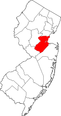
Cranbury is an unincorporated community and census-designated place (CDP) [9] in Cranbury Township, Middlesex County, New Jersey, in the United States. [10] [11] As of the 2020 United States census, the CDP's population was 2,200. [3] Unlike in some other New Jersey townships, the Cranbury CDP is only part of Cranbury Township.
Cranbury is in southern Middlesex County, in the east-central part of Cranbury Township. U.S. Route 130 forms the eastern border of the CDP; the highway leads south 2 miles (3 km) to Hightstown and north 14 miles (23 km) to New Brunswick, the Middlesex county seat. Trenton, the state capital, is 15 miles (24 km) to the southwest.
According to the U.S. Census Bureau, the Cranbury CDP has a total area of 1.243 square miles (3.22 km2), including 1.224 square miles (3.17 km2) of land and 0.019 square miles (0.049 km2) of water (1.53%). [1] Cranbury Brook passes through the southern part of the community, flowing west to join the Millstone River at Princeton Junction. Via the Millstone, Cranbury is within the Raritan River watershed flowing to Lower New York Bay.
Census | Pop. | Note | %± |
---|---|---|---|
2000 | 2,008 | — | |
2010 | 2,181 | 8.6% | |
2020 | 2,200 | 0.9% | |
Population sources: 2000 [12] 2010 [13] 2020 [3] |
The 2010 United States census counted 2,181 people, 722 households, and 572 families in the CDP. The population density was 1,818.5 people per square mile (702.1 people/km2). There were 745 housing units at an average density of 621.2 units per square mile (239.8 units/km2). The racial makeup was 82.49% (1,799) White, 4.08% (89) Black or African American, 0.05% (1) Native American, 11.23% (245) Asian, 0.05% (1) Pacific Islander, 0.18% (4) from other races, and 1.93% (42) from two or more races. Hispanic or Latino of any race were 2.25% (49) of the population. [13]
Of the 722 households, 44.9% had children under the age of 18; 69.3% were married couples living together; 7.9% had a female householder with no husband present and 20.8% were non-families. Of all households, 18.4% were made up of individuals and 6.5% had someone living alone who was 65 years of age or older. The average household size was 2.85 and the average family size was 3.29. [13]
29.0% of the population were under the age of 18, 4.9% from 18 to 24, 16.5% from 25 to 44, 33.8% from 45 to 64, and 15.7% who were 65 years of age or older. The median age was 44.7 years. For every 100 females, the population had 92.7 males. For every 100 females ages 18 and older there were 84.9 males. [13]
As of the 2000 United States Census [6] there were 2,008 people, 703 households, and 534 families living in the CDP. The population density was 625.2 people/km2 (1,619 people/sq mi). There were 728 housing units at an average density of 226.7 units/km2 (587 units/sq mi). The racial makeup of the CDP was 88.35% White, 1.89% African American, 8.12% Asian, 0.20% from other races, and 1.44% from two or more races. Hispanic or Latino of any race were 1.49% of the population. [12]
There were 703 households, out of which 45.7% had children under the age of 18 living with them, 69.4% were married couples living together, 5.0% had a female householder with no husband present, and 23.9% were non-families. 20.3% of all households were made up of individuals, and 10.2% had someone living alone who was 65 years of age or older. The average household size was 2.79 and the average family size was 3.27. [12]
In the CDP the population was spread out, with 30.9% under the age of 18, 2.4% from 18 to 24, 30.1% from 25 to 44, 23.3% from 45 to 64, and 13.2% who were 65 years of age or older. The median age was 39 years. For every 100 females, there were 91.2 males. For every 100 females age 18 and over, there were 86.2 males. [12]
The median income for a household in the CDP was $104,444, and the median income for a family was $129,877. Males had a median income of $95,316 versus $44,500 for females. The per capita income for the CDP was $51,095. About 1.1% of families and 2.2% of the population were below the poverty line, including 4.0% of those under age 18 and 1.4% of those age 65 or over. [12]
Brownville is an unincorporated community and census-designated place (CDP) in Old Bridge Township, Middlesex County, New Jersey, United States. As of the 2020 census, the population was 2,746, up from 2,383 in 2010.
Concordia is an unincorporated community and census-designated place (CDP) in Monroe Township, Middlesex County, New Jersey, United States. The CDP is oriented around the age restricted gated community of Concordia. As of the 2020 United States census, the CDP's population was 2,455, down from 3,092 in 2010. Prior to 2020, the corner of Concordia known as The Ponds was split off into its own CDP.
Dayton is an unincorporated community and census-designated place (CDP) in South Brunswick Township, Middlesex County, New Jersey, in the United States. At the 2020 United States census, the CDP's population was 8,138, up from 7,063 in 2010.
Fords is a census-designated place (CDP) located within Woodbridge Township, in Middlesex County, in the U.S. state of New Jersey. As of the 2010 United States Census, the CDP's population was 15,187.
Heathcote is an unincorporated community and census-designated place (CDP) located within South Brunswick, in Middlesex County, in the U.S. state of New Jersey. As of the 2010 United States Census, the CDP's population was 5,821.
Kendall Park is an unincorporated community and census-designated place (CDP) located within South Brunswick Township, in Middlesex County, in the U.S. state of New Jersey. As of the 2010 United States Census, the CDP's population was 9,339. Kendall Park has a post office with its own ZIP Code (08824) that encompasses the entire CDP, as well as some surrounding areas.
Kingston is an unincorporated community and census designated place (CDP) along the border of South Brunswick Township in Middlesex County and Franklin Township in Somerset County, and also located relatively near Princeton in Mercer County in the U.S. state of New Jersey. The historic settlement is in the Raritan Valley region, located along the course of the Millstone River. As of the 2010 United States Census, the CDP's population was 1,493, of which 1,222 were in South Brunswick Township and 271 in Franklin Township.
Madison Park is an unincorporated community and census-designated place (CDP) located within Old Bridge Township, in Middlesex County, in the U.S. state of New Jersey. As of the 2010 United States Census, the CDP's population was 7,144. The name "Madison Park" reflects Old Bridge's original name of "Madison Township" which it had when it was formed on March 2, 1869, from portions of South Amboy Township, until November 5, 1975, when voters approved a referendum changing the township's name to Old Bridge Township.
Old Bridge is a census-designated place (CDP) located in Old Bridge Township, in Middlesex County, in the U.S. state of New Jersey. As of the 2010 United States Census, the CDP's population was 23,753. Despite the similarity in the name of the CDP and the township, the two are not one and the same, as had been the case for most paired Township / CDP combinations prior to the 2010 Census, in which the CDP was coextensive with a township of the same name.
Plainsboro Center is an unincorporated community and census-designated place (CDP) located within Plainsboro Township, situated in southern Middlesex County, within the U.S. state of New Jersey. As of the 2020 United States census, the CDP's population was 2,760, its highest decennial count ever and an increase of 48 (+1.8%) from the 2,712 recorded at the 2010 census, which in turn reflected an increase of 503 (+22.8%) from the 2,209 counted in the 2000 census.
Port Reading is an unincorporated community and census-designated place (CDP) located within Woodbridge Township, in Middlesex County, in the U.S. state of New Jersey. As of the 2010 U.S. census, Port Reading's population was 3,728.
Princeton Meadows is an unincorporated community and census-designated place (CDP) located within Plainsboro Township, in Middlesex County, in the U.S. state of New Jersey. As of the 2010 United States Census, the CDP's population was 13,834.
Rossmoor is an unincorporated community and census-designated place (CDP) located within Monroe Township in Middlesex County, in the U.S. state of New Jersey. As of the 2010 United States Census, the CDP's population was 2,666.
Sewaren is an unincorporated community and census-designated place (CDP) within Woodbridge Township, in Middlesex County, in the U.S. state of New Jersey. As of the 2010 United States Census, the CDP's population was 2,756.
Society Hill is an unincorporated community and census-designated place (CDP) located within Piscataway Township, in Middlesex County, in the U.S. state of New Jersey. As of the 2010 United States Census, the CDP's population was 3,829.
Whittingham, also known as Greenbriar at Whittingham, is an unincorporated community and census-designated place (CDP) located within Monroe Township, in Middlesex County, in the U.S. state of New Jersey. As of the 2010 United States Census, the CDP's population was 2,476. The area is focused around the age-restricted gated community of Whittingham.
Woodbridge is an unincorporated community and census-designated place (CDP) within Woodbridge Township, in Middlesex County, in the U.S. state of New Jersey. As of the 2010 United States Census, the CDP's population was 19,265. Despite the similarity in the name of the CDP and the township, the two are not coextensive; the CDP occupies 15.7% of the township's 24.51 square miles (63.5 km2).
Crandon Lakes is an unincorporated community and census-designated place (CDP) split between Hampton Township and Stillwater Township, in Sussex County, in the U.S. state of New Jersey. As of the 2010 United States Census, the CDP's population was 1,178, of which 682 were in Hampton Township and 496 in Stillwater Township.
Ramtown is a census-designated place and unincorporated community located within Howell Township, in Monmouth County, in the U.S. state of New Jersey. As of the 2010 United States Census, the CDP's population was 6,242.
Clearbrook is a gated community and census-designated place (CDP) in Monroe Township, Middlesex County, New Jersey, United States. The CDP was named Clearbrook Park in the 2000 and 2010 censuses and renamed in 2020. As of the 2020 United States census, the CDP's population was 2,909, up from 2,667 in 2010.