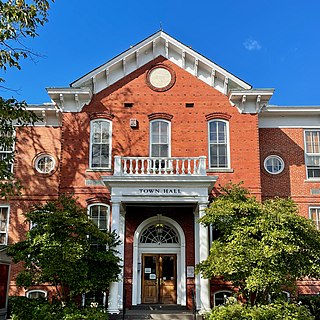
Cranbury is a township in southern Middlesex County, within the U.S. state of New Jersey. As of the 2020 United States census, the township's population was 3,842, a decrease of 15 (−0.4%) from the 2010 census count of 3,857, which in turn reflected an increase of 630 (+19.5%) from the 3,227 counted in the 2000 census.

Jamesburg is a borough in Middlesex County, in the U.S. state of New Jersey. As of the 2020 United States census, the borough's population was 5,783, a decrease of 132 (−2.2%) from the 2010 census count of 5,915, which in turn reflected a decline of 110 (−1.8%) from the 6,025 counted in the 2000 census.

Monroe Township is a township located in southern Middlesex County, in the U.S. state of New Jersey. The township is centrally located within the Raritan Valley region and is an outer-ring suburb of New York City within the New York metropolitan area. As of the 2020 United States census, the township's population was 48,594, its highest decennial count ever and an increase of 9,462 (+24.2%) from the 39,132 recorded at the 2010 census, which in turn reflected an increase of 11,133 (+39.8%) from the 27,999 counted in the 2000 census. Monroe Township also comprises the largest land area of any municipality in Middlesex County, at approximately 42 square miles (110 km2).

Plainsboro Township is a township situated in southern Middlesex County, in the U.S. state of New Jersey. Centrally located in the Raritan Valley region, the township is an outer-ring suburb of New York City in the New York metropolitan area, even though it is slightly geographically closer to Center City, Philadelphia than to Midtown Manhattan. As of the 2020 United States census, the township's population was 24,084, its highest decennial count ever and an increase of 1,085 (+4.7%) from the 22,999 recorded at the 2010 census, which in turn reflected an increase of 2,784 (+13.8%) from the 20,215 counted in the 2000 census.

Central Jersey, or Central New Jersey, is the middle region of the U.S. state of New Jersey. The designation Central Jersey is a distinct administrative toponym. While New Jersey is often divided into North Jersey and South Jersey, many residents recognize Central Jersey as a distinct third entity. As of the 2020 census, Central Jersey has a population of 3,580,999.

Applegarth is an unincorporated community located within Monroe Township in Middlesex County, in the U.S. state of New Jersey. The settlement is located in the southern portion of the township and is traversed by the road of the same name, Applegarth Road. At the location of the original settlement, at the intersection of Applegarth, Wycoffs Mills, and Old Church Roads, there is a restaurant, farmland, and the Applegarth Fire Department. Further north along Applegarth Road are housing developments, age-restricted communities, and two elementary schools: Applegarth and Oak Tree.

Cranbury Station is an unincorporated community located within Cranbury Township in Middlesex County, in the U.S. state of New Jersey. The area immediately around the site of the former railroad station along the Camden and Amboy Railroad contains agricultural businesses and small homes. Hightstown-Cranbury Station Road is the main road through the settlement paralleling the railroad and Station Road as a major road heading east and west through the area. Modern warehouses line Station Road and the nearby New Jersey Turnpike west of the station while large housing developments are located east of here in Monroe Township.

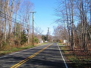
Hoffman is an unincorporated community located within Monroe Township in Middlesex County, in the U.S. state of New Jersey. The settlement is located at the site of a former railroad station on the Freehold and Jamesburg Agricultural Railroad. Today, most of the area is made up of homes and housing developments along Hoffman Station Road and Gravel Hill-Spotswood Road. Forestland and the Manalapan Brook valley make up the remainder of the area.

Fresh Ponds is an unincorporated community located within South Brunswick Township in Middlesex County, in the U.S. state of New Jersey. It is located in a rural portion of the township at the intersection of Fresh Ponds Road and Davidson Mill Road. Forest land, farms, homes, and a church are located around the settlement.
Gravel Hill or Gravelhill is an unincorporated community located within Monroe Township in Middlesex County, in the U.S. state of New Jersey. Located in a rural part of Monroe Township, the area is made up of approximately half farmland and half forestland. Homes line the roads that run through the area.
Half Acre is an unincorporated community located within Monroe Township in Middlesex County, in the U.S. state of New Jersey. The settlement is located roughly at the intersection of Prospect Plains Road and Half Acre Road in the center of the township. Some single-family homes and small businesses are located along those two roads and Cranbury-Half Acre Road but most of the area is made up of age-restricted housing developments including Concordia, Clearbrook Park, Greenbriar at Whittingham, and Encore at Monroe.

Prospect Plains is an unincorporated community located within Monroe Township in Middlesex County, in the U.S. state of New Jersey. The settlement is located at the intersection of Prospect Plains Road and Applegarth Road. Retail businesses generally line the two aforementioned county roads in the area but some single-family houses are clustered around the site of the Camden & Amboy railroad crossing of Prospect Plains Road.
Sand Hills is an unincorporated community located within South Brunswick Township in Middlesex County, in the U.S. state of New Jersey. The settlement is named for Sand Hills, a small group of diabase hills which contains Middlesex County's highest point. The settlement is located approximately at the intersection of U.S. Route 1, Sand Hills Road, and Major Road. There is a small cluster of houses and small businesses on Major Road just south of US 1 while more housing developments are found on the north side of the highway. Fast food restaurants, stores, and repair shops line US 1 through the area; this area of US 1 also has large inclines on both sides of the hills to climb from the relatively low and flat areas of the Atlantic coastal plain.
Shore Road Estates is an unincorporated community located within Monroe Township in Middlesex County, in the U.S. state of New Jersey.

Spotswood Manor is an unincorporated community located within Monroe Township in Middlesex County, in the U.S. state of New Jersey. The settlement is located just south of the borough of Spotswood, most of them consist of small homes, though businesses and strip malls line Spotswood-Englishtown Road, the main road through the area.
Tracy is an unincorporated community located within Monroe Township in Middlesex County, in the U.S. state of New Jersey. The settlement is located at the site of a former station on the Freehold and Jamesburg Agricultural Railroad in the southeastern edge of the township. Most of the area is forestland with some homes and light commercial businesses located along Federal Road and Tracy Station Road.

Union Valley is an unincorporated community located within Monroe Township in Middlesex County, in the U.S. state of New Jersey. Two large age-restricted communities lie within the settlement today, Clearbrook Park and Concordia. Other than those two communities, the only other buildings in the area are medical offices and facilities and some single-family homes along Union Valley Road.

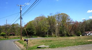
Wyckoffs Mills is an unincorporated community located along the border of Cranbury and Monroe townships in Middlesex County, in the U.S. state of New Jersey. Located at the intersection of Wyckoff Mills Road and Wyckoffs Mills Road, the area only contains lots containing residential structures; the remainder of the land is made up of farmland and wetlands. The Millstone River flows to the south of the settlement and a 500-kilovolt transmission line crosses the farmland to the north and south.

Old Church is an unincorporated community located within Monroe Township in Middlesex County, in the U.S. state of New Jersey. The settlement is named for a Presbyterian community that settled on the site but relocated to Cranbury c. 1740. Originally, the area was farmland. One of the farms in the area was the Dey Farm, in existence since the founding of Monroe Township in 1838 and the site of a command post used by George Washington during the Battle of Monmouth in 1778. Starting in 2004, the area experienced a major change from its agricultural roots to single-family residences on the south side of the area and age-restricted communities to the north. This redevelopment also caused the severing of the main north–south road, Old Church Road and the extension of Federal Road which formerly had its western end at Old Church Road to Applegarth Road. The a farmhouse named England House was moved 4,000 feet (1,200 m) to the Dey Farm site to preserve the area's history prior to the construction of the new houses in 2004.


