Deans is an unincorporated community and census-designated place (CDP) in South Brunswick Township, Middlesex County, New Jersey, in the United States. As of the 2020 United States census, Deans had a population of 1,615.
Bonhamtown is a section of Edison Township in Middlesex County, New Jersey, United States.

Cheesequake is an unincorporated community located within Old Bridge Township in Middlesex County, in the U.S. state of New Jersey. Cheesequake is located along Route 34, south of Cheesequake State Park.

Hoffman is an unincorporated community located within Monroe Township in Middlesex County, in the U.S. state of New Jersey. The settlement is located at the site of a former railroad station on the Freehold and Jamesburg Agricultural Railroad. Today, most of the area is made up of homes and housing developments along Hoffman Station Road and Gravel Hill-Spotswood Road. Forestland and the Manalapan Brook valley make up the remainder of the area.

Little Rocky Hill is an unincorporated community located within South Brunswick in Middlesex County and Franklin Township, Somerset County, in the U.S. state of New Jersey. The community is located atop a small hill east of the borough of Rocky Hill. The Middlesex–Somerset county line runs through the community along Old Road though elsewhere it follows Route 27. Carters Brook runs through the area flowing south.

Middlesex Downs is an unincorporated community located within Monroe Township in Middlesex County, in the U.S. state of New Jersey. The wholly residential settlement contains small homes along Dey Grove Road and Bergen Mills Road with larger homes in developments towards the south. The township-owned James Monroe Memorial Park is also located in this settlement. Much of the area to the north of Dey Grove Road consists of forest land but at one time this was planned to become a large planned community arranged in a street grid. The small property parcels and paper streets remain on township tax maps today.
North Stelton is an unincorporated community located within Piscataway in Middlesex County, in the U.S. state of New Jersey.

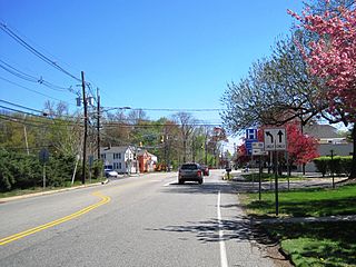
Orchard Heights is an unincorporated community located within East Brunswick Township in Middlesex County, in the U.S. state of New Jersey. The area is part of a suburban residential neighborhood between Milltown and Dunhams Corner Roads interchange with New Jersey Route 18. Near the area includes two schools, churches, and St. Mary's Cemetery. The subdivision was planned and built in about 1954.

Possumtown is an unincorporated community located within Piscataway Township in Middlesex County, in the U.S. state of New Jersey. The area is mostly a residential neighborhood nestled between Possumtown Road, River Road and Interstate 287. The neighborhood has two parks within its environs: Wynnewood Park and Possumtown Park.
Sayerwood South or Sayrewood South is an unincorporated community located within Old Bridge Township in Middlesex County, in the U.S. state of New Jersey.
Sayreville Station is a neighborhood in Sayreville in Middlesex County, in the U.S. state of New Jersey. Originally terminus of Raritan River Railroad's Sayreville Branch between Upper and Lower Sayreville. The spur was abandoned in 1978.
Shore Road Estates is an unincorporated community located within Monroe Township in Middlesex County, in the U.S. state of New Jersey.
Tracy is an unincorporated community located within Monroe Township in Middlesex County, in the U.S. state of New Jersey. The settlement is located at the site of a former station on the Freehold and Jamesburg Agricultural Railroad in the southeastern edge of the township. Most of the area is forestland with some homes and light commercial businesses located along Federal Road and Tracy Station Road.

Union Valley is an unincorporated community located within Monroe Township in Middlesex County, in the U.S. state of New Jersey. Two large age-restricted communities lie within the settlement today, Clearbrook Park and Concordia. Other than those two communities, the only other buildings in the area are medical offices and facilities and some single-family homes along Union Valley Road.
West Carteret is an unincorporated community located within Carteret in Middlesex County, in the U.S. state of New Jersey. Joseph Medwick Park is a greenway of parkland along the banks the Rahway River.
Ardena is an unincorporated community located within Howell Township in Monmouth County, in the U.S. state of New Jersey. The community is located along County Route 524 near Vanderveer Road in the western part of the township. The area consists of about half farmland and half residential developments.

Bergerville is an unincorporated community located within Howell Township in Monmouth County, in the U.S. state of New Jersey. The area was originally developed as a resort bungalow community in the first half of the 20th century.

Freewood Acres is an unincorporated community located within Howell Township in Monmouth County, in the U.S. state of New Jersey. The area is made up of mostly single-story homes arranged along a street grid in the northern reaches of the Pine Barrens. U.S. Route 9 runs through the center of the community just north of its interchange with Interstate 195. The Land O'Pines Elementary School and Manasquan Reservoir County Park exist to the east of the community. It became the center of the Kalmyk American community in the latter part of the 20th century.


