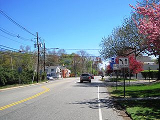
Deans is an unincorporated community and census-designated place (CDP) in South Brunswick Township, Middlesex County, New Jersey, in the United States. As of the 2020 United States census, Deans had a population of 1,615.
Cumberland is a small unincorporated community located within Maurice River Township in Cumberland County, in the U.S. state of New Jersey. For statistical purposes, Cumberland and neighboring Hesstown together comprise the Cumberland-Hesstown census-designated place.

Poyntelle is a village that is located in Preston Township, Wayne County, Pennsylvania, United States, in the Lake Region of the Poconos.

Chairville is a rural unincorporated community located along the border of Medford and Southampton townships in Burlington County, in the U.S. state of New Jersey. The settlement is named for a chair parts factory that operated from 1845 to 1890. Also located in the area were the Peacock Cemetery, a sawmill, and a one-room schoolhouse. Today, the site is located at the intersection of Chairville Road and New Jersey Route 70 and Little Creek.

Prospertown is an unincorporated community located within the New Jersey townships of Jackson and Plumsted in Ocean County and Upper Freehold in Monmouth County. The community is home to Prospertown Lake and is adjacent to Six Flags Great Adventure, both located on County Route 537. The center of the community is located at the intersection of CR 537, Hawkin Road, and Emleys Hill Road. Most of the area consists of pine forests but there are some homes along the roads in the area.

Cranbury Station is an unincorporated community located within Cranbury Township in Middlesex County, in the U.S. state of New Jersey. The area immediately around the site of the former railroad station along the Camden and Amboy Railroad contains agricultural businesses and small homes. Hightstown-Cranbury Station Road is the main road through the settlement paralleling the railroad and Station Road as a major road heading east and west through the area. Modern warehouses line Station Road and the nearby New Jersey Turnpike west of the station while large housing developments are located east of here in Monroe Township.

Cottageville is an unincorporated community located within South Brunswick Township in Middlesex County, in the U.S. state of New Jersey. The settlement is located along Davidson Mill Road at the former Newark–Trenton Fast Line right-of-way, now a PSE&G transmission line corridor. The trolley stop at the settlement allowed for summer cottages to be built in the area leading to the area's name. Today, some of the older homes remain in addition to a summer camp, forest land, and PSE&G's Deans substation.
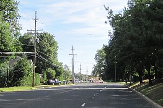
Half Acre is an unincorporated community located within Monroe Township in Middlesex County, in the U.S. state of New Jersey. The settlement is located roughly at the intersection of Prospect Plains Road and Half Acre Road in the center of the township. Some single-family homes and small businesses are located along those two roads and Cranbury-Half Acre Road but most of the area is made up of age-restricted housing developments including Concordia, Clearbrook Park, Greenbriar at Whittingham, and Encore at Monroe.

Middlesex Downs is an unincorporated community located within Monroe Township in Middlesex County, in the U.S. state of New Jersey. The wholly residential settlement contains small homes along Dey Grove Road and Bergen Mills Road with larger homes in developments towards the south. The township-owned James Monroe Memorial Park is also located in this settlement. Much of the area to the north of Dey Grove Road consists of forest land but at one time this was planned to become a large planned community arranged in a street grid. The small property parcels and paper streets remain on township tax maps today.
Tracy is an unincorporated community located within Monroe Township in Middlesex County, in the U.S. state of New Jersey. The settlement is located at the site of a former station on the Freehold and Jamesburg Agricultural Railroad in the southeastern edge of the township. Most of the area is forestland with some homes and light commercial businesses located along Federal Road and Tracy Station Road.

Union Valley is an unincorporated community located within Monroe Township in Middlesex County, in the U.S. state of New Jersey. Two large age-restricted communities lie within the settlement today, Clearbrook Park and Concordia. Other than those two communities, the only other buildings in the area are medical offices and facilities and some single-family homes along Union Valley Road.

Wyckoffs Mills is an unincorporated community located along the border of Cranbury and Monroe townships in Middlesex County, in the U.S. state of New Jersey. Located at the intersection of Wyckoff Mills Road and Wyckoffs Mills Road, the area only contains lots containing residential structures; the remainder of the land is made up of farmland and wetlands. The Millstone River flows to the south of the settlement and a 500-kilovolt transmission line crosses the farmland to the north and south.

Charleston Springs is an unincorporated community located within Millstone Township in Monmouth County, in the U.S. state of New Jersey. Stage Coach Road, also designated County Route 524, is the main road that runs through the settlement, with Ely Harmony Road as the intersecting road defining the locality. The Manalapan Brook runs to the west of the center of Charleston Springs and CR 537 runs to the south of the area. The Monmouth County-owned Charleston Springs Golf Course is located one mile (1.6 km) northeast of the center of Charleston Springs on CR 527.

Ely is an unincorporated community located within Millstone Township in Monmouth County, in the U.S. state of New Jersey. The settlement is named for the Ely family that owned property in the area and operated the Charleston Springs hotel. Today, the settlement is located along Stage Coach Road, County Route 524, in the eastern portion of the township. Most of the area consists of large single-family homes though some farmland and the township-owned Brandywine Soccer Complex are located in the near the settlement.

Fairfield is an unincorporated community located within Howell Township in Monmouth County, in the U.S. state of New Jersey. The community is centered on the intersection of County Route 524 (CR 524) and Ketchum Road, where the Colonial Era Our House Tavern is located. The area includes several small businesses, township offices and schools. There are also small farms and residential developments in the area. Fairfield was a stop on the Freehold and Jamesburg Agricultural Railroad.

Lower Squankum is an unincorporated community located within Howell Township in Monmouth County, in the U.S. state of New Jersey. The settlement is located along Lakewood-Farmingdale Road at its intersection with Herbertsville Road and Old Tavern Road in the eastern side of the township. It is also located near the boundary of Allaire State Park and is south of Interstate 195's exit 31. Nearby the community are the remains of the Lower Squankum Mill and the Lower Squankum Friends Burial Site, located within the median of CR 547 at the aforementioned interchange.

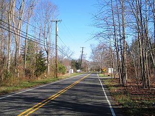
Red Valley is an unincorporated community located within Upper Freehold Township in Monmouth County, in the U.S. state of New Jersey. The settlement is located at the intersection of County Route 526 and Red Valley Road (south) and Yellow Meetinghouse Road (north) near the township's eastern border with Millstone Township. Except for some single-family houses located along the roads in the area, the area is primarily made up of farmland.

Old Church is an unincorporated community located within Monroe Township in Middlesex County, in the U.S. state of New Jersey. The settlement is named for a Presbyterian community that settled on the site but relocated to Cranbury c. 1740. Originally, the area was farmland. One of the farms in the area was the Dey Farm, in existence since the founding of Monroe Township in 1838 and the site of a command post used by George Washington during the Battle of Monmouth in 1778. Starting in 2004, the area experienced a major change from its agricultural roots to single-family residences on the south side of the area and age-restricted communities to the north. This redevelopment also caused the severing of the main north–south road, Old Church Road and the extension of Federal Road which formerly had its western end at Old Church Road to Applegarth Road. The a farmhouse named England House was moved 4,000 feet (1,200 m) to the Dey Farm site to preserve the area's history prior to the construction of the new houses in 2004.

Davisville is an unincorporated community located within Chesterfield Township in Burlington County, in the U.S. state of New Jersey. The settlement, located at the intersection of County Route 528 and Chesterfield-Arneytown Road, is in a rural area in the eastern portion of the township. It consists mainly of farmland with some houses dotting the few roads that pass through the area.


