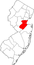
Menlo Park Terrace, New Jersey

Last updated

Menlo Park Terrace, New Jersey
Location map of Middlesex County, New Jersey.svg
Red pog.svg
Menlo Park Terrace
Location in Middlesex County
USA New Jersey relief location map.svg
Red pog.svg
Menlo Park Terrace
Location in New Jersey
Usa edcp relief location map.png
Red pog.svg
Menlo Park Terrace
Location in the United States
Coordinates: 40°33′12″N74°19′27″W / 40.55333°N 74.32417°W / 40.55333; -74.32417 [1] [2]
Country Flag of the United States.svg  United States
State Flag of New Jersey.svg  New Jersey
County Middlesex
Township Woodbridge
Named for Menlo Park
ZIP Code
08840
FIPS code 34-45450 [3]

Menlo Park Terrace is an unincorporated community and census-designated place (CDP) [4] and census-designated place located within Woodbridge Township in Middlesex County, in the U.S. state of New Jersey. [5] It is located off U.S. Route 1 in between Menlo Park Mall and Woodbridge Center at Exit 130 of the Garden State Parkway.

See also

Related Research Articles

<span class="mw-page-title-main">Middlesex County, New Jersey</span> County in New Jersey, United States

Middlesex County is located in central New Jersey, United States, extending inland from the Raritan Valley region to the northern portion of the Jersey Shore. As of the 2020 United States census, the county was the state's third-most populous county with a population of 863,162, its highest decennial count ever and an increase of 53,304 (+6.6%) from the 2010 census count of 809,858, which in turn reflected an increase of 4,725 (0.9%) from the 750,162 counted in the 2000 census. Middlesex is part of the New York metropolitan area. Many communities within the county serve as commuter towns to and from New York City and other points north.

<span class="mw-page-title-main">Avenel, New Jersey</span> Populated place in Middlesex County, New Jersey, US

Avenel is an unincorporated community and census-designated place (CDP) located within Woodbridge Township, in Middlesex County, in the U.S. state of New Jersey. Avenel is approximately 25 miles (40 km) southwest of Midtown Manhattan along the North Jersey Coast rail line

<span class="mw-page-title-main">Colonia, New Jersey</span> Place in Middlesex County, New Jersey, United States

Colonia is an unincorporated community and census-designated place (CDP) located within Woodbridge Township, in Middlesex County, in the U.S. state of New Jersey. As of the 2010 United States Census, the CDP's population was 17,795.

<span class="mw-page-title-main">Edison, New Jersey</span> Township in Middlesex County, New Jersey, United States

Edison is a township located in Middlesex County, in the U.S. state of New Jersey. Situated in Central New Jersey within the core of the state's Raritan Valley region, Edison is a commercial hub and is a bedroom community of New York City within the New York metropolitan area. As of the 2020 United States census, the township was the state's sixth-most-populous municipality, with a population of 107,588, an increase of 7,621 (+7.6%) from the 2010 census count of 99,967, which in turn reflected an increase of 2,280 (+2.3%) from the 97,687 counted in the 2000 census.

<span class="mw-page-title-main">Fords, New Jersey</span> Populated place in Middlesex County, New Jersey, US

Fords is an unincorporated community and census-designated place (CDP) located within Woodbridge Township, in Middlesex County, in the U.S. state of New Jersey. As of the 2010 United States Census, the CDP's population was 15,187.

<span class="mw-page-title-main">Iselin, New Jersey</span> Populated place in Middlesex County, New Jersey, US

Iselin is an unincorporated community and census-designated place (CDP) located within Woodbridge Township, in Middlesex County, in the U.S. state of New Jersey. As of the 2010 United States census, Iselin's population was 18,695.

<span class="mw-page-title-main">Port Reading, New Jersey</span> Populated place in Middlesex County, New Jersey, US

Port Reading is a census-designated place and unincorporated community located within Woodbridge Township, in Middlesex County, in the U.S. state of New Jersey. As of the 2010 U.S. census, Port Reading's population was 3,728.

<span class="mw-page-title-main">Woodbridge (CDP), New Jersey</span> Census-designated place in New Jersey, United States

Woodbridge is an unincorporated community and census-designated place (CDP) within Woodbridge Township, in Middlesex County, in the U.S. state of New Jersey. As of the 2010 United States Census, the CDP's population was 19,265. Despite the similarity in the name of the CDP and the township, the two are not coextensive; the CDP occupies 15.7% of the township's 24.51 square miles (63.5 km2).

<span class="mw-page-title-main">Woodbridge Township, New Jersey</span> Township in Middlesex County, New Jersey, United States

Woodbridge Township is a township in northern Middlesex County, in the U.S. state of New Jersey. The township is a regional hub of transportation and commerce for central New Jersey and a major bedroom suburb of New York City, within the New York metropolitan area. Located within the core of the Raritan Valley region, Woodbridge Township hosts the junction of the New Jersey Turnpike and the Garden State Parkway, the two busiest highways in the state, and also serves as the headquarters for the New Jersey Turnpike Authority, which operates both highways.

<span class="mw-page-title-main">Neshanic, New Jersey</span> Populated place in Somerset County, New Jersey, US

Neshanic is an unincorporated community and census-designated place (CDP) located within Hillsborough Township, in Somerset County, in the U.S. state of New Jersey. It is located near the South Branch Raritan River. The Neshanic Historic District was listed on the National Register of Historic Places in 1979.

<span class="mw-page-title-main">Keasbey, New Jersey</span> Populated place in Middlesex County, New Jersey, US

Keasbey is a census-designated place (CDP) and unincorporated community located within Woodbridge Township, in Middlesex County, in the U.S. state of New Jersey. It is located in the western outskirts of adjacent Perth Amboy. As of the 2020 census, the CDP's population was 3,027. Many Hispanic / Latino families have relocated from Perth Amboy to Keasbey.

Hopelawn is an unincorporated community and census-designated place (CDP) located within Woodbridge Township in Middlesex County, in the U.S. state of New Jersey.

The Woodbridge Township School District is a comprehensive community public school district that serves students in kindergarten through twelfth grade from Woodbridge Township in Middlesex County, New Jersey, United States. All schools are accredited by the Middle States Association of Colleges and Schools.

Landing is an unincorporated community and census-designated place (CDP) located within Roxbury Township, in Morris County, New Jersey, United States. The community is located on the south shore of Lake Hopatcong near Hopatcong State Park. The area is served as United States Postal Service ZIP Code 07850.

<span class="mw-page-title-main">Woodbridge Center</span> Shopping mall in Woodbridge, New Jersey

Woodbridge Center is a major two-level shopping mall located in Woodbridge Township, in the U.S. state of New Jersey, at the intersection of U.S. Route 1 and U.S. Route 9. As of 2022, the mall features Macy's, Boscov's, J. C. Penney, and Dick's Sporting Goods.

<span class="mw-page-title-main">Jobstown, New Jersey</span> Populated place in Burlington County, New Jersey, US

Jobstown is an unincorporated community and census-designated place (CDP) located within Springfield Township in Burlington County, in the U.S. state of New Jersey. The area is served as United States Postal Service ZIP code 08041.

Absecon Highlands is an unincorporated community and census-designated place (CDP) in Atlantic County, in the U.S. state of New Jersey. It is in the eastern part of the county, in southern Galloway Township. It is bordered to the south by the city of Absecon and to the east by Reeds Bay, a tidal water body the connects to the Atlantic Ocean through Broad Creek and Absecon Inlet. The CDP includes the neighborhoods of Absecon Highlands, Seaview Estates, Seaview Park, Conovertown, and Holly Brook.

Arrowhead Lake is an unincorporated community and census-designated place (CDP) in Cumberland County, in the U.S. state of New Jersey. It is in the northwestern part of the county, in the northern part of Stow Creek Township. A small artificial lake is in the northwestern part of the CDP, with a residential neighborhood on its southern shore.

Ampere North is a unincorporated community and census-designated place (CDP) in Bloomfield Township, Essex County, in the U.S. state of New Jersey. It is in the southern corner of the township, bordered to the north by the Watsessing CDP, to the northeast by Silver Lake, to the southwest by East Orange, and to the southeast by Newark. Ampere Parkway runs through the center of the CDP, from Bloomfield Avenue at the northeast border of the community, south into the Ampere neighborhood in East Orange.

References

  1. "TigerWeb".
  2. "FCC converter". December 11, 2015.
  3. Geographic Codes Lookup for New Jersey, Missouri Census Data Center. Accessed April 1, 2022.
  4. State of New Jersey Census Designated Places - BVP20 - Data as of January 1, 2020, United States Census Bureau. Accessed December 1, 2022.
  5. Locality Search, State of New Jersey.