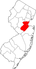
Forsgate, New Jersey | |
---|---|
Location in Middlesex County Location in New Jersey | |
Coordinates: 40°20′55″N74°27′49″W / 40.34861°N 74.46361°W | |
Country | United States |
State | New Jersey |
County | Middlesex |
Township | Monroe |
Area | |
• Total | 0.88 sq mi (2.28 km2) |
• Land | 0.88 sq mi (2.27 km2) |
• Water | 0.00 sq mi (0.01 km2) |
Elevation | 145 ft (44 m) |
Population | |
• Total | 2,056 |
• Density | 2,349.71/sq mi (906.96/km2) |
Time zone | UTC−05:00 (Eastern (EST)) |
• Summer (DST) | UTC−04:00 (EDT) |
ZIP Code | 08831 (Monroe Township) |
Area code(s) | 732/848 |
FIPS code | 34-24285 [3] |
GNIS feature ID | 2806083 [4] |
Forsgate is a golf course community and census-designated place (CDP) [5] in Monroe Township, Middlesex County, New Jersey, United States. It consists of Forsgate Country Club and its associated housing developments. As of the 2020 United States census, it had a population of 2,056. [2]
Forsgate is in southern Middlesex County, in the northwestern part of Monroe Township, bordered to the south across Forsgate Drive by Rossmoor, to the east by the Hightstown Industrial Track rail line, to the north by a branch rail line connecting Jamesburg and Monmouth Junction, and to the west by the New Jersey Turnpike at Exit 8A. It is 13 miles (21 km) south of New Brunswick and 19 miles (31 km) northeast of Trenton.
According to the U.S. Census Bureau, the Forsgate CDP has an area of 0.879 square miles (2.277 km2), of which 0.004 square miles (0.010 km2), or 0.46%, are water. [1] Land in the CDP drains northeast toward Manalapan Brook, a northeast-flowing tributary of the South River, part of the Raritan River watershed.
The community was first listed as a CDP prior to the 2020 census. [4]
Census | Pop. | Note | %± |
---|---|---|---|
2020 | 2,056 | — | |
U.S. Decennial Census [6] 2020 [2] |
Brownville is an unincorporated community and census-designated place (CDP) in Old Bridge Township, Middlesex County, New Jersey, United States. As of the 2020 census, the population was 2,746, up from 2,383 in 2010.
Concordia is an unincorporated community and census-designated place (CDP) in Monroe Township, Middlesex County, New Jersey, United States. The CDP is oriented around the age restricted gated community of Concordia. As of the 2020 United States census, the CDP's population was 2,455, down from 3,092 in 2010. Prior to 2020, the corner of Concordia known as The Ponds was split off into its own CDP.
Cranbury is an unincorporated community and census-designated place (CDP) in Cranbury Township, Middlesex County, New Jersey, in the United States. As of the 2020 United States census, the CDP's population was 2,200. Unlike in some other New Jersey townships, the Cranbury CDP is only part of Cranbury Township.
Dayton is an unincorporated community and census-designated place (CDP) in South Brunswick Township, Middlesex County, New Jersey, in the United States. At the 2020 United States census, the CDP's population was 8,138, up from 7,063 in 2010.
Fords is a census-designated place (CDP) in Woodbridge Township, Middlesex County, New Jersey, in the United States. As of the 2020 census, the CDP's population was 12,941.
Heathcote is an unincorporated community and census-designated place (CDP) in South Brunswick Township, Middlesex County, New Jersey, United States. As of the 2020 census, the population of the CDP was 7,154, up from 5,821 in 2010.
Madison Park is an unincorporated community and census-designated place (CDP) located within Old Bridge Township, in Middlesex County, in the U.S. state of New Jersey. As of the 2010 United States Census, the CDP's population was 7,144. The name "Madison Park" reflects Old Bridge's original name of "Madison Township" which it had when it was formed on March 2, 1869, from portions of South Amboy Township, until November 5, 1975, when voters approved a referendum changing the township's name to Old Bridge Township.
Old Bridge is a census-designated place (CDP) located in Old Bridge Township, in Middlesex County, in the U.S. state of New Jersey. As of the 2010 United States Census, the CDP's population was 23,753. Despite the similarity in the name of the CDP and the township, the two are not one and the same, as had been the case for most paired Township / CDP combinations prior to the 2010 Census, in which the CDP was coextensive with a township of the same name.
Plainsboro Center is an unincorporated community and census-designated place (CDP) located within Plainsboro Township, situated in southern Middlesex County, within the U.S. state of New Jersey. As of the 2020 United States census, the CDP's population was 2,760, its highest decennial count ever and an increase of 48 (+1.8%) from the 2,712 recorded at the 2010 census, which in turn reflected an increase of 503 (+22.8%) from the 2,209 counted in the 2000 census.
Princeton Meadows is an unincorporated community and census-designated place (CDP) located within Plainsboro Township, in Middlesex County, in the U.S. state of New Jersey. As of the 2010 United States Census, the CDP's population was 13,834.
Rossmoor is an unincorporated community and census-designated place (CDP) located within Monroe Township in Middlesex County, in the U.S. state of New Jersey. As of the 2010 United States Census, the CDP's population was 2,666.
Whittingham, also known as Greenbriar at Whittingham, is an unincorporated community and census-designated place (CDP) located within Monroe Township, in Middlesex County, in the U.S. state of New Jersey. As of the 2010 United States Census, the CDP's population was 2,476. The area is focused around the age-restricted gated community of Whittingham.
Deans is an unincorporated community and census-designated place (CDP) in South Brunswick Township, Middlesex County, New Jersey, in the United States. As of the 2020 United States census, Deans had a population of 1,615.
Clearbrook is a gated community and census-designated place (CDP) in Monroe Township, Middlesex County, New Jersey, United States. The CDP was named Clearbrook Park in the 2000 and 2010 censuses and renamed in 2020. As of the 2020 United States census, the CDP's population was 2,909, up from 2,667 in 2010.
Encore at Monroe is a gated community and census-designated place (CDP) in Monroe Township, Middlesex County, New Jersey, United States. As of the 2020 census, it had a population of 625.
Monroe Manor is a census-designated place (CDP) located in Monroe Township, Middlesex County, in the U.S. state of New Jersey. It is in the southernmost part of Middlesex County and consists of the developments of Monroe Manor and Monroe Place. It is bordered to the south by Millstone Township in Monmouth County and to the west by the Renaissance at Monroe development. New Jersey Route 33 forms the northern border of the CDP, leading west 2.5 miles (4.0 km) to Hightstown and east 11 miles (18 km) to Freehold.
Regency at Monroe is a gated community and census-designated place (CDP) located in Monroe Township, Middlesex County, in the U.S. state of New Jersey. It is in the eastern part of the township, bordered by Mounts Mills Road to the north, Spotswood-Englishtown Road to the east, and Buckelew Avenue to the southwest. It is 7 miles (11 km) northwest of Freehold, 15 miles (24 km) south-southeast of New Brunswick, and 22 miles (35 km) northeast of Trenton.
Renaissance at Monroe is a planned community and census-designated place (CDP) in Monroe Township, Middlesex County, in the U.S. state of New Jersey. It is in the southwest part of the township, bordered to the east by Monroe Manor and to the east by East Windsor Township in Mercer County. New Jersey Route 33 forms the northern edge of the community; it is 1.5 miles (2.4 km) west to Exit 8 on the New Jersey Turnpike and 11 miles (18 km) east to Freehold.
Stonebridge is a gated community and census-designated place (CDP) in Monroe Township, Middlesex County, in the U.S. state of New Jersey. It is in the southwestern part of the township, bordered to the north, across Union Valley Road, by Clearbrook, to the west by Applegarth Road, and to the south by Federal Road. It is 5 miles (8 km) south of Jamesburg and 4 miles (6 km) northeast of Hightstown.
The Ponds is a planned community and census-designated place (CDP) in Monroe Township, Middlesex County, in the U.S. state of New Jersey. It is in the southern part of the township, bordered to the west by Clearbrook, to the north and east by Concordia, and to the south by Union Valley Road. It is 4 miles (6 km) south of Jamesburg and 5 miles (8 km) northeast of Hightstown.