
Middlesex County is a county located in the north-central part of the U.S. state of New Jersey, extending inland from the Raritan Valley region to the northern portion of the Jersey Shore. As of the 2020 United States census, the county was the state's third-most populous county with a population of 863,162, its highest decennial count ever and an increase of 53,304 (+6.6%) from the 2010 census count of 809,858, which in turn reflected an increase of 59,696 (8.0%) from the 750,162 counted in the 2000 census. Middlesex is part of the New York metropolitan area. Many communities within the county serve as commuter towns to and from New York City and other points north. The county is part of the Central Jersey region of the state.
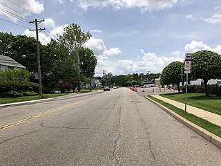
Brownville is an unincorporated community and census-designated place (CDP) in Old Bridge Township, Middlesex County, New Jersey, United States. As of the 2020 census, the population was 2,746, up from 2,383 in 2010.
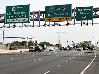
East Brunswick is a township in Middlesex County, in the U.S. state of New Jersey. The suburban bedroom community is part of the New York City metropolitan area and is located on the southern shore of the Raritan River, directly adjacent to the city of New Brunswick and located roughly 29 miles (47 km) away from New York City. As of the 2020 United States census, the township's population was 49,715, its highest decennial count ever and an increase of 2,203 (+4.6%) from the 2010 census count of 47,512, which in turn reflected an increase of 756 (+1.6%) from the 46,756 counted in the 2000 census.
Old Bridge Township is a township in Middlesex County, in the U.S. state of New Jersey, located in the Raritan Valley region and within the New York metropolitan area. As of the 2020 United States census, the township was the state's 21st-most-populous municipality, with a population of 66,876, an increase of 1,501 (+2.3%) from the 2010 census count of 65,375, which in turn reflected an increase of 4,919 (+8.1%) from the 60,456 counted in the 2000 census. As of the 2010 Census, the township was ranked 18th in the state by population, after being the state's 21st most-populous municipality in 2000. Old Bridge is a bedroom suburb of New York City located across the Raritan Bay from Staten Island, and it is about 25 miles (40 km) from Manhattan, and about 30 miles (48 km) south of Newark.

Plainsboro Township is a township situated in southern Middlesex County, in the U.S. state of New Jersey. Centrally located in the Raritan Valley region, the township is an outer-ring suburb of New York City in the New York metropolitan area, even though it is slightly geographically closer to Center City, Philadelphia than to Midtown Manhattan. As of the 2020 United States census, the township's population was 24,084, its highest decennial count ever and an increase of 1,085 (+4.7%) from the 22,999 recorded at the 2010 census, which in turn reflected an increase of 2,784 (+13.8%) from the 20,215 counted in the 2000 census.

Sayreville is a borough in Middlesex County, in the U.S. state of New Jersey. Sayreville is within the heart of the Raritan Valley region, located on the south banks of the Raritan River, and also located on the Raritan Bay. As of the 2020 United States census, the borough's population was 45,345, an increase of 2,641 (+6.2%) from the 2010 census count of 42,704, which in turn reflected an increase of 2,327 (+5.8%) from the 40,377 counted in the 2000 census.

West Freehold is an unincorporated community and census-designated place (CDP) within Freehold Township, in Monmouth County, New Jersey, United States. As of the 2010 United States Census, the CDP's population was 13,613. Due to the community's close proximity to the Battle of Monmouth, West Freehold is home to several important historical structures, which have been preserved in the 'West Freehold Village Historic District'. The historically preserved Monmouth Battlefield, along with the historic villages of Clarksburg, Englishtown, Smithburg and Tennent are a short distance away.

North Brunswick is a township in Middlesex County, in the U.S. state of New Jersey. It is centrally located in the Raritan Valley region within the New York metropolitan area. As of the 2020 United States census, the township's population was 43,905, an increase of 3,163 (+7.8%) from the 2010 census count of 40,742, which in turn reflected an increase of 3,455 (+12.3%) from the 36,287 counted in the 2000 census.
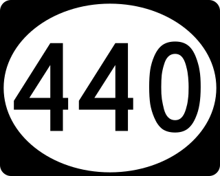
Route 440 is a state highway in New Jersey, United States. It comprises two segments, a 5.15-mile (8.29 km) freeway in Middlesex County linking Interstate 287 (I-287) and the New Jersey Turnpike (I-95), in Edison to the Outerbridge Crossing in Perth Amboy and an 8.18-mile (13.16 km) four-lane divided highway in Hudson County running from the Bayonne Bridge in Bayonne to U.S. Route 1/9 Truck in Jersey City. These two segments are connected by New York State Route 440 (NY 440), which runs across Staten Island. The freeway portion in Middlesex County is six lanes wide and interchanges with the Garden State Parkway and US 9 in Woodbridge.

Central Jersey, or Central New Jersey, is the middle region of the U.S. state of New Jersey. The designation Central Jersey is a distinct administrative toponym. While New Jersey is often divided into North Jersey and South Jersey, many residents recognize Central Jersey as a distinct third entity. As of the 2020 census, Central Jersey has a population of 3,580,999.

County Route 520 is a county highway in the U.S. state of New Jersey. County Route 520 is a major road across Monmouth County connecting the county's central towns to the Jersey Shore at Sea Bright. The highway extends 22.39 miles (36.03 km) from Englishtown Road in Old Bridge to Ocean Avenue in Sea Bright.

U.S. Route 1 (US 1) is a U.S. Route which parallels the East Coast of the United States, running from Key West, Florida, in the south to Fort Kent, Maine, at the Canadian border in the north. Of the entire length of the route, 66.06 miles (106.31 km) of it runs through New Jersey. It enters the state from Pennsylvania on the Trenton–Morrisville Toll Bridge over the Delaware River in the state capital of Trenton, running through the city on the Trenton Freeway. From here, US 1 continues northeast as a surface divided highway through suburban areas, heading into Middlesex County and passing through New Brunswick and Edison. US 1 merges with US 9 in Woodbridge, and the two routes continue through northern New Jersey as US 1/9 to the George Washington Bridge over the Hudson River in Fort Lee. At this point, the road continues into New York City along with I-95.
Bonhamtown is a section of Edison Township in Middlesex County, New Jersey, United States.

Smithburg is an unincorporated community located where the municipal boundaries of Freehold, Manalapan and Millstone townships intersect in Monmouth County, in the U.S. state of New Jersey. County Route 527 and Monmouth Road pass through the center of the quaint village of Smithburg.

Cheesequake is an unincorporated community located within Old Bridge Township in Middlesex County, in the U.S. state of New Jersey. Cheesequake is located along Route 34, south of Cheesequake State Park.

Middlesex Downs is an unincorporated community located within Monroe Township in Middlesex County, in the U.S. state of New Jersey. The wholly residential settlement contains small homes along Dey Grove Road and Bergen Mills Road with larger homes in developments towards the south. The township-owned James Monroe Memorial Park is also located in this settlement. Much of the area to the north of Dey Grove Road consists of forest land but at one time this was planned to become a large planned community arranged in a street grid. The small property parcels and paper streets remain on township tax maps today.

Spotswood Manor is an unincorporated community located within Monroe Township in Middlesex County, in the U.S. state of New Jersey. The settlement is located just south of the borough of Spotswood, most of them consist of small homes, though businesses and strip malls line Spotswood-Englishtown Road, the main road through the area.

Cooleys Corner is an unincorporated community located within Upper Freehold Township in Monmouth County, in the U.S. state of New Jersey. The site of the settlement is within the Assunpink Wildlife Management Area, a New Jersey Department of Environmental Protection Division of Fish and Wildlife-operated preserved area in Monmouth and Mercer counties along the Assunpink Creek. Before the creation of the Assunpink Lake in the 1970s, the area consisted of farmland located at the intersection of Clarksburg Road and Imlaystown-Hightstown Road. Some farmland is still present in the area but is now mostly used by hunters. The main boat ramp to Assunpink Lake is located along the former Imlaystown-Hightstown Road.

Old Church is an unincorporated community located within Monroe Township in Middlesex County, in the U.S. state of New Jersey. The settlement is named for a Presbyterian community that settled on the site but relocated to Cranbury c. 1740. Originally, the area was farmland. One of the farms in the area was the Dey Farm, in existence since the founding of Monroe Township in 1838 and the site of a command post used by George Washington during the Battle of Monmouth in 1778. Starting in 2004, the area experienced a major change from its agricultural roots to single-family residences on the south side of the area and age-restricted communities to the north. This redevelopment also caused the severing of the main north–south road, Old Church Road and the extension of Federal Road which formerly had its western end at Old Church Road to Applegarth Road. The a farmhouse named England House was moved 4,000 feet (1,200 m) to the Dey Farm site to preserve the area's history prior to the construction of the new houses in 2004.


