
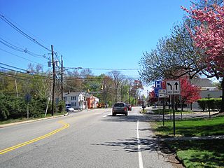
Ewing Township is a township in Mercer County, in the U.S. state of New Jersey. The township falls within the New York metropolitan area as defined by the U.S. Census Bureau. It borders the Philadelphia metropolitan area and is part of the Federal Communications Commission's Philadelphia Designated Market Area. As of the 2020 United States census, the township's population was 37,264, its highest decennial count ever and an increase of 1,474 (+4.1%) from the 35,790 recorded at the 2010 census, which in turn reflected an increase of 83 (+0.2%) from the 35,707 counted in the 2000 census.
Deans is an unincorporated community and census-designated place (CDP) in South Brunswick Township, Middlesex County, New Jersey, in the United States. As of the 2020 United States census, Deans had a population of 1,615.

Raven Rock is an unincorporated community and hamlet along the Delaware River approximately three miles (4.8 km) north of Stockton along New Jersey Route 29. The hamlet was known earlier as Saxtonville. It is located within Delaware Township in Hunterdon County, in the U.S. state of New Jersey. It is the site of Bull's Island Recreation Area. The rock outcrop for which it is named is the southwest corner of the Hunterdon Plateau.

Rutherford is a New Jersey Transit railroad station served by the Bergen County Line located in Rutherford, New Jersey, United States. The station is located near a traffic circle at the junction of Park Avenue, Union Avenue, Erie Avenue and Orient Way known as Station Square, with a grade crossing on Park Avenue.

New Lisbon is an unincorporated community located within Pemberton Township in Burlington County, in the U.S. state of New Jersey. It is a settlement along Four Mile Road where it intersects Mount Misery Road. The community is located along the Philadelphia and Long Branch Railway, later a part of the Pennsylvania Railroad, and featured a train station.

Hornerstown is an unincorporated community located within Upper Freehold Township in Monmouth County, in the U.S. state of New Jersey. Hornerstown is located near Cream Ridge and uses the 08514 ZIP code.

Applegarth is an unincorporated community located within Monroe Township in Middlesex County, in the U.S. state of New Jersey. The settlement is located in the southern portion of the township and is traversed by the road of the same name, Applegarth Road. At the location of the original settlement, at the intersection of Applegarth, Wycoffs Mills, and Old Church Roads, there is a restaurant, farmland, and the Applegarth Fire Department. Further north along Applegarth Road are housing developments, age-restricted communities, and two elementary schools: Applegarth and Oak Tree.

Chapel Hill is an unincorporated community located within Middletown Township, in Monmouth County, in the U.S. state of New Jersey. As its name implies, the area is on a high spot within the township between Fairview and Leonardo just south of the Naval Weapons Station Earle Waterfront Section. Unlike other areas of Middletown Township, the Chapel Hill section is not as developed with single-family homes; only a few housing developments are located off the area's main roads, Kings Highway and Chapel Hill Road. The rest of the area outside NWS Earle consists of horse farms and forestland.

Penns Neck is an unincorporated community located within West Windsor Township in Mercer County, in the U.S. state of New Jersey. The community developed at the intersection of the Trenton-New Brunswick Turnpike and Washington Road. The Penns Neck Circle and the historic Penns Neck Baptist Church (1812) are both located in Penns Neck. The Princeton Branch rail line, known as the Dinky, has run through the area since 1865, and stopped at Penns Neck station until January 1971.

Cranbury Station is an unincorporated community located within Cranbury Township in Middlesex County, in the U.S. state of New Jersey. The area immediately around the site of the former railroad station along the Camden and Amboy Railroad contains agricultural businesses and small homes. Hightstown-Cranbury Station Road is the main road through the settlement paralleling the railroad and Station Road as a major road heading east and west through the area. Modern warehouses line Station Road and the nearby New Jersey Turnpike west of the station while large housing developments are located east of here in Monroe Township.

Hoffman is an unincorporated community located within Monroe Township in Middlesex County, in the U.S. state of New Jersey. The settlement is located at the site of a former railroad station on the Freehold and Jamesburg Agricultural Railroad. Today, most of the area is made up of homes and housing developments along Hoffman Station Road and Gravel Hill-Spotswood Road. Forestland and the Manalapan Brook valley make up the remainder of the area.

Prospect Plains is an unincorporated community located within Monroe Township in Middlesex County, in the U.S. state of New Jersey. The settlement is located at the intersection of Prospect Plains Road and Applegarth Road. Retail businesses generally line the two aforementioned county roads in the area but some single-family houses are clustered around the site of the Camden & Amboy railroad crossing of Prospect Plains Road.

Schalks or Schalks Station is an unincorporated community located within Plainsboro Township in Middlesex County, in the U.S. state of New Jersey. Located along Schalks Crossing Road at its junction with the Northeast Corridor railroad tracks, the area contains single-family homes, forested areas, a former research nuclear reactor built by Industrial Reactor Laboratories, and the rear yards to offices within the Princeton Forrestal Center.

Fairfield is an unincorporated community located within Howell Township in Monmouth County, in the U.S. state of New Jersey. The community is centered on the intersection of County Route 524 (CR 524) and Ketchum Road, where the Colonial Era Our House Tavern is located. The area includes several small businesses, township offices and schools. There are also small farms and residential developments in the area. Fairfield was a stop on the Freehold and Jamesburg Agricultural Railroad.

Nelsonville is an unincorporated community located within Upper Freehold Township in Monmouth County, in the U.S. state of New Jersey. The settlement is located on County Route 526 between Allentown and Imlaystown where it intersects the former Pemberton and Hightstown Railroad. The site was the location of the Newell post office established in 1883. The area was originally known as Imlaystown Station as it was the closest spot to the eponymous town along the railroad. In 1887, the area was renamed to Nelsonville for the local postmaster, Charles Nelson. Other industries in the area at the time included a wagon shop and a cider mill. Today, several agricultural and light industries surround the settlement in addition to some single-family homes. The right-of-way of the former railroad is being reconstructed as the Union Transportation Trail.

Ewansville or Ewanville is an unincorporated community located in Burlington County, in the U.S. state of New Jersey. The community is centered on the crossing of U.S. Route 206 (US 206) and the North Branch Rancocas Creek just north of the former Philadelphia and Long Branch Railway. Ewansville was the site of a station on the aforementioned railroad and was the terminus for a short spur track to Vincentown.

Sharon is an unincorporated community located within Upper Freehold Township in Monmouth County, in the U.S. state of New Jersey. Located at the intersection of Herbert Road and Sharon Station Road, the settlement is the site of a former stop on the Pemberton and Hightstown Railroad. Except for a few single-family homes in the area, most of the area is farmland. The railroad has since been abandoned and is being converted to the Union Transportation Trail, a rail trail. Sharon is the current northern terminus of the trail.

Browns Mills Junction is an unincorporated community located within Pemberton Township in Burlington County, in the U.S. state of New Jersey. The site, located about 1.6 miles (2.6 km) southwest of downtown Browns Mills, is located at the crossing of Junction Road and the Philadelphia and Long Branch Railway, later a part of the Pennsylvania Railroad. It was the site of a train station named Browns Mills in-the-Pines where a short branch connected the main line to Browns Mills. The settlement features a few houses along Junction Road and Mount Misery Road but is otherwise very forested as a part of the New Jersey Pine Barrens.

Bullock is an unincorporated community that straddles Woodland Township, Burlington County and Manchester Township, Ocean County in the middle of the New Jersey Pine Barrens. Much of the area surrounding Bullock is a part of the Brendan T. Byrne State Forest though there are some clearings for small houses along Savoy Boulevard in Woodland Township and Pasadena Road in Manchester Township. The settlement is located where these two roads, the New Jersey Southern Railroad, and the Keith line converge.

North Bergen was a railroad station in North Bergen, New Jersey, United States known Homestead for most of its existence. It as built in the mid 19th century and served by the New York, Susquehanna and Western Railway (#1059) and the Erie Railroad's Northern Branch (#1903).


