Roosevelt Park (Edison, New Jersey)

Last updated

Roosevelt Park
RooseveltParkStonemon1933a.jpg
Roosevelt Park stone monument (detail, top front)
Location map of Middlesex County, New Jersey.svg
Red pog.svg
USA New Jersey location map.svg
Red pog.svg
Location Edison, New Jersey, United States
Coordinates 40°33′18″N74°20′18″W / 40.555108°N 74.338409°W / 40.555108; -74.338409
Area217 acres (88 ha)
Created1933
Operated by Middlesex County

Roosevelt Park is a 217-acre park located in central east Edison, New Jersey, at Parsonage Road and U.S. Route 1, just west of Menlo Park Mall. Established in 1933 in what was then Raritan Township, the park is considered the oldest park in the Middlesex County Park System. It is owned and operated by the county government.

Contents

History

On July 5, 1917, the Middlesex County Board of Freeholders authorized the purchase of 208 acres of land in Raritan Township for the construction of a county hospital for tuberculosis patients. [1] According to The Guide to Edison Township, the purchased land was "free of population and free from any kind of buildings. The closest people to it was one farmer and the nearest populated area was downtown Metuchen". On April 7, 1919, NJ Assembly Bill 498, which sought to establish a bond to facilitate the funding of construction of the hospital, died in committee, leaving the prospects for a new hospital in doubt. There was discussion of selling the land purchased for a hospital. [2] On October 10, 1923, the Middlesex County Recreation Association hosted a luncheon/meeting at the Hotel Klein in New Brunswick and received broad support from local agencies and state and local officials to create the county's first park on the lands once designated for the tuberculosis hospital. [3] A fundraising campaign to construct a Kiddie Keep Well camp on part of the grounds of the new county park was conducted 7-14 September 1924. [4]

The Middlesex County freeholders established Roosevelt Park with funding from the Emergency Relief Administration in 1933 and subsequent improvements through the Civilian Conservation Corps (CCC) and the Works Progress Administration (WPA). Hundreds of CCC workers of the Second Corps Area (New York, Connecticut and New Jersey) trained at Camp Dix in the summers of 1934 and 1935 and were positioned at a camp seven miles west of Raritan train station, likely Raritan Arsenal. In particular, Company 1209 was trained by the US Army in forestry operations and worked in Raritan Township on CCC Project P-67 beginning August 8, 1935.

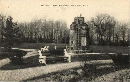
The Middlesex County Board of Chosen Freeholders erected a large stone monument in 1933 dedicated to the park and the men of the county who built it. It is situated at the edge of the park along Route 1 North, just north of the Parsonage Road overpass, near the intersection of Lafayette Avenue and Roosevelt Drive.

The county tuberculosis hospital—Roosevelt Hospital—was built adjacent to and overlooking the park. The county received $575,000 in federal funding through the Public Works Administration and construction began on May 3, 1935. The hospital was dedicated on October 31, 1936, and opened March 8, 1937. The hospital was added to the National Register of Historic Places in 2002. [5]

Light Dispelling Darkness, a fountain designed by the sculptor Waylande Gregory, was sponsored by the WPA and unveiled in 1938. The theme of enlightenment through knowledge and science was inspired in part by the proximity of Menlo Park, where Thomas Edison invented the light bulb. The fountain is 15 feet high and 40 feet in diameter, with six symbolic groups representing "War", "Pestilence", "Famine", "Death", "Greed", and "Materialism". The fountain was restored in 2004 after falling into disrepair.

Sports and recreation

Winter in Roosevelt Park Roosevelt Park.jpg
Winter in Roosevelt Park

The park provides a wide range of facilities for sports and recreation, including fields for baseball and soccer; picnic areas equipped with tables and bbq grills; miles of trails for bicycling, hiking, walking and jogging; courts for basketball and tennis; fishing at an eight-acre man-made lake; and a rink for ice skating or roller skating, depending on the season.

"The Level Playing Fields" provides dedicated sports facilities for people with physical and other special needs, including a fully equipped artificial-turf diamond with backstop, dugouts, and grandstands for spectators).

The East Coast Greenway, a 3,000 mile long system of trails connecting Maine and Florida, goes through the park.

Arts and education

Plaque on "Iron Mike" monument (2003) RooseveltParkCcc2003b.JPG
Plaque on "Iron Mike" monument (2003)

Chapter 24 of the National Association of Civilian Conservation Corps Alumni and the Middlesex County Board of Chosen Freeholders erected a monument dedicated on 31 March 2003 recognizing the work of the Civilian Conservation Corps (1933-1942). The statue, nicknamed "Iron Mike", is a representation of the typical CCC worker, spade in hand. It is situated on Lafayette Avenue near the corner of US Route 1 North and Grandview Avenue.

Two monuments dedicated to Marie Curie can be found on Elm Drive in the park, one erected in 1938 and the other in 1993.

The Middlesex County Veterans Memorial was unveiled on Veterans Day in November 2001. It consists of eight large concrete walls, six representing the various military services and two with dedications and memorials to the county's veterans, and a fountain with sculptures.

The Lakeview School and Rehabilitation Center for children with cerebral palsy is located within Roosevelt Park.

The Kiddie Keep Well Camp was established in 1924 to treat children with tuberculosis.

In the summer, the county sponsors various outdoor theater festivals, including "Plays in the Park" and "Music in the Park."

Related Research Articles

Civilian Conservation Corps US voluntary public work relief program from 1933-42

The Civilian Conservation Corps (CCC) was a voluntary public work relief program that operated from 1933 to 1942 in the United States for unemployed, unmarried men ages 18–25 and eventually expanded to ages 17–28. Robert Fechner was the first director of this agency, succeeded by James McEntee following Fechner's death. The CCC was a major part of President Franklin D. Roosevelt's New Deal that provided manual labor jobs related to the conservation and development of natural resources in rural lands owned by federal, state, and local governments. The CCC was designed to provide jobs for young men and to relieve families who had difficulty finding jobs during the Great Depression in the United States. Maximum enrollment at any one time was 300,000. Through the course of its nine years in operation, three million young men participated in the CCC, which provided them with shelter, clothing, and food, together with a wage of $30 per month.

Route 18 is a 42.8-mile-long (68.9 km) state highway in the US state of New Jersey. It begins at an intersection with Route 138 in Wall Township and ends at Interstate 287 (I-287) in Piscataway. Much of the route is a limited-access freeway, including the entire portion in Monmouth County and much of the northern end through New Brunswick and Piscataway. The remainder of the route is a multi-lane divided highway. Route 18 was designated in 1939 as a proposed freeway from Old Bridge to Eatontown. The section west of Old Bridge was formerly designated as part Route S28, a prefixed spur of State Highway Route 28 from Middlesex to Matawan. The designation, assigned in the 1927 renumbering, remained until a second renumbering in 1953. At that point, Route S28 was redesignated as Route 18, though the section from Old Bridge to Matawan was signed as TEMP 18, as this section would be decommissioned when the Route 18 freeway was built.

Route 27 is a state highway in New Jersey, United States. It runs 38.53 mi (62.01 km) from U.S. Route 206 in Princeton, Mercer County northeast to an interchange with Route 21 and Broad Street in Newark, Essex County. The route passes through many communities along the way, including New Brunswick, Highland Park, Edison, Metuchen, Rahway, and Elizabeth. Route 27 is a two- to four-lane undivided highway for most of its length, passing through a variety of urban and suburban environments. It intersects many roads along the way, including Route 18 in New Brunswick, Interstate 287 in Edison, the Garden State Parkway in Woodbridge Township, Route 35 in Rahway, Route 28 in Elizabeth, and U.S. Route 22 in Newark. Route 27 crosses the Raritan River on the Albany Street Bridge, which connects Highland Park on the east with New Brunswick on the west.

Middlesex County, New Jersey County in New Jersey

Middlesex County is located in central New Jersey, United States. In 2019, the Census Bureau estimated the county's population at 825,062, making it the state's second-most populous county, an increase of 4.1% from 809,858 in the 2010 census. Middlesex is part of the New York metropolitan area, and its county seat is New Brunswick. The center of population of the state of New Jersey is located in Middlesex County, in East Brunswick Township, just east of the New Jersey Turnpike. The 2000 Census showed that the county ranked 63rd in the United States among the wealthiest counties by median household income. The Bureau of Economic Analysis ranked the county as having the 143rd-highest per capita income of all 3,113 counties in the United States as of 2009. Middlesex County holds the nickname, The Greatest County in the Land.

Edison, New Jersey Township in Middlesex County, New Jersey, United States

Edison is a township located in Middlesex County, New Jersey, United States. Situated in central New Jersey, Edison lies within the core of the state's Raritan Valley region and is a bedroom suburb in the New York City metropolitan area. As of the 2010 United States Census, Edison had a total population of 99,967, retaining its position as the fifth-most populous municipality in New Jersey. The 2010 population reflected an increase of 2,280 (+2.3%) from the 97,687 counted in the 2000 Census, which had in turn increased by 9,007 (+10.2%) from the 88,680 counted in 1990. Edison's population surpassed the 100,000 threshold since 2010, increasing by 0.7% to a Census-estimated 100,693 in 2018 before dipping back to 99,758 in 2019.

Highland Park, New Jersey Borough in Middlesex County, New Jersey, United States

Highland Park is a borough in Middlesex County, New Jersey, United States in the New York City metropolitan area. The borough is located on the northern banks of the Raritan River, in the Raritan Valley region. As of the 2010 United States Census, the borough's population was 13,982, reflecting a decline of 17 (−0.1%) from the 13,999 counted in the 2000 Census, which had in turn increased by 720 (+5.4%) from the 13,279 counted in the 1990 Census.

Metuchen, New Jersey Borough in Middlesex County, New Jersey, United States

Metuchen is a suburban borough in Middlesex County, New Jersey, United States. The borough is a bedroom suburb of New York City, located in the heart of the Raritan Valley region within the New York Metropolitan area. The borough, along with Edison, is a regional commercial hub for Central New Jersey. The borough is 5 miles (8.0 km) northeast of New Brunswick, 19 miles (31 km) southwest of Newark, 26 miles (42 km) southwest of Jersey City, and 33 miles (53 km) southwest of Manhattan. As of the 2010 United States Census, the borough's population was 13,574, reflecting an increase of 734 (+5.7%) from the 12,840 counted in the 2000 Census, which had in turn increased by 36 (+0.3%) from the 12,804 counted in the 1990 Census.

New Brunswick, New Jersey City in Middlesex County, New Jersey, United States

New Brunswick is a city in Middlesex County, New Jersey, United States. The city is the county seat of Middlesex County, and is the home of Rutgers University. The city is both a regional commercial hub for the Central New Jersey region and a prominent and growing commuter town for residents commuting to New York City within the New York metropolitan area. New Brunswick is on the Northeast Corridor rail line, 27 miles (43 km) southwest of Manhattan. The city is located on the southern banks of the Raritan River in the Raritan Valley region.

Old Bridge Township, New Jersey Township in New Jersey, United States

Old Bridge Township is a township in Middlesex County, New Jersey, United States. The township is located within the core of the Raritan Valley region. As of the 2010 United States Census, the township had a total population of 65,375, reflecting an increase of 4,919 (+8.1%) from the 60,456 counted in the 2000 Census, which had in turn increased by 3,981 (+7.0%) from the 56,475 counted in the 1990 Census. As of the 2010 Census, the township was the state's 18th largest municipality, after being the state's 21st most-populous municipality in 2000. Old Bridge is a bedroom suburb of New York City located across the Raritan Bay from Staten Island, and it is about 25 miles (40 km) from Manhattan, and about 30 miles (48 km) south of Newark.

Piscataway, New Jersey Township in Middlesex County, New Jersey, United States

Piscataway is a township in Middlesex County, New Jersey, United States. The township is a major bedroom suburb of the New York metropolitan area, located within the heart of the Raritan Valley region. As of the 2010 United States Census, the township's population was 56,044, reflecting an increase of 5,562 (+11.0%) from the 50,482 counted in the 2000 Census, which had in turn increased by 3,393 (+7.2%) from the 47,089 counted in 1990.

Plainsboro Township, New Jersey Township in Middlesex County, New Jersey, United States

Plainsboro Township is a township in Middlesex County in the U.S. state of New Jersey. The township is centrally located in the Raritan Valley region and is a part of the New York metropolitan area. As of the 2010 United States Census, the township's population was 22,999, reflecting an increase of 2,784 (+13.8%) from the 20,215 counted in the 2000 Census, which had in turn increased by 6,002 (+42.2%) from the 14,213 counted in the 1990 Census.

Sayreville, New Jersey Borough in Middlesex County, New Jersey, United States

Sayreville is a borough in Middlesex County, New Jersey, United States. Sayreville is within the heart of the Raritan Valley region, located on the south banks of the Raritan River, and also located relatively near the Raritan Bay. As of the 2010 United States Census, the borough's population was 42,704, reflecting an increase of 2,327 (+5.8%) from the 40,377 counted in the 2000 Census, which had in turn increased by 5,391 (+15.4%) from the 34,986 counted in the 1990 Census.

South Amboy, New Jersey City in Middlesex County, New Jersey, United States

South Amboy is a suburban city in Middlesex County, New Jersey, on the Raritan Bay. As of the 2010 United States Census, the city's population was 8,631, reflecting an increase of 718 (+9.1%) from the 7,913 counted in the 2000 Census, which had in turn increased by 50 (+0.6%) from the 7,863 counted in the 1990 Census.

Raritan River

The Raritan River is a major river of central New Jersey in the United States. Its watershed drains much of the mountainous area of the central part of the state, emptying into the Raritan Bay on the Atlantic Ocean.

Menlo Park, New Jersey Unincorporated community in New Jersey, United States

Menlo Park is an unincorporated community located within Edison Township in Middlesex County, New Jersey, United States.

Central Jersey Place in New Jersey, United States

Central Jersey is a central region of the U.S. state of New Jersey. The designation of Central New Jersey with a distinct toponym is a colloquial one rather than an administrative one.

Thomas Alva Edison Memorial Tower and Museum United States historic place

The Thomas Edison Center at Menlo Park, also known as the Menlo Park Museum / Edison Memorial Tower, is a memorial to inventor and businessman Thomas Alva Edison, located in the Menlo Park area of Edison, Middlesex County, New Jersey. The tower was dedicated on February 11, 1938, on what would have been the inventor's 91st birthday.

Bonhamtown, New Jersey Unincorporated community in New Jersey, United States

Bonhamtown is a section of Edison Township in Middlesex County, New Jersey, United States.

Roosevelt Hospital (Edison, New Jersey) United States historic place

Roosevelt Hospital is a historic building at 1 Roosevelt Drive in Edison, Middlesex County, New Jersey. Construction of the hospital was started in 1935 and completed in 1937. The building was added to the National Register of Historic Places on March 5, 2002 for its significance in health and medicine, in particular the treatment of tuberculosis. It was designed with Colonial Revival style and built with red brick.

References

  1. Daily Home News, New Brunswick, New Jersey, 6 July 1917, pp 1, 4
  2. Daily Home News, New Brunswick, New Jersey, 8 April 1919, page 1
  3. Daily Home News, New Brunswick, New Jersey, 11 October 1923, pages 1, 2
  4. Daily Home News, 14 Aug 1924, page 14
  5. Spies, Stacy E; Wyatt, Barbara; Zerbe, Nancy L. (May 1, 2001). "National Register of Historic Places Inventory/Nomination: Roosevelt Hospital". National Park Service. With accompanying 18 photos

Sources

Coordinates: 40°33′18″N74°20′18″W / 40.555108°N 74.338409°W / 40.555108; -74.338409