
A floodplain or flood plain or bottomlands is an area of land adjacent to a river. Floodplains stretch from the banks of a river channel to the base of the enclosing valley, and experience flooding during periods of high discharge. The soils usually consist of clays, silts, sands, and gravels deposited during floods.

Woodbridge Township is a township in northern Middlesex County, in the U.S. state of New Jersey. The township is a regional hub of transportation and commerce for central New Jersey and a major bedroom suburb of New York City, within the New York metropolitan area. Located within the core of the Raritan Valley region, Woodbridge Township hosts the junction of the New Jersey Turnpike and the Garden State Parkway, the two busiest highways in the state, and also serves as the headquarters for the New Jersey Turnpike Authority, which operates both highways.

The Raritan River is the longest and largest river of the U.S. state of New Jersey. Its watershed drains much of the mountainous area of the central region and a smaller portion of the northern region of the state, emptying into the Raritan Bay near Staten Island on the Atlantic Ocean.

The Passaic River is a river, approximately 80 miles (130 km) long, in Northern New Jersey. The river in its upper course flows in a highly circuitous route, meandering through the swamp lowlands between the ridge hills of rural and suburban northern New Jersey, called the Great Swamp, draining much of the northern portion of the state through its tributaries.

The Hackensack River is a river, approximately 45 miles (72 km) long, in the U.S. states of New York and New Jersey, emptying into Newark Bay, a back chamber of New York Harbor. The watershed of the river includes part of the suburban area outside New York City just west of the lower Hudson River, which it roughly parallels, separated from it by the New Jersey Palisades. It also flows through and drains the New Jersey Meadowlands. The lower river, which is navigable as far as the city of Hackensack, is heavily industrialized and forms a commercial extension of Newark Bay.
The Rahway River is a river in Essex, Middlesex, and Union Counties, New Jersey, United States, The Rahway, along with the Elizabeth River, Piles Creek, Passaic River, Morses Creek, the Fresh Kills River, has its river mouth at the Arthur Kill.

The Metedeconk River is a tributary of Barnegat Bay in Ocean County, New Jersey in the United States.

The River Alt is an urban river that flows across Merseyside in England. The river has suffered from heavy pollution from industry and sewage upstream and run-off from farmland in its lower reaches. It empties into the River Mersey, near to where the Mersey itself flows into the Irish Sea. The river has benefited from clean-up schemes and a de-culverting process to improve its water quality and provide a better environment for wildlife.
Salt Brook is a tributary of the Passaic River in Union County, New Jersey in the United States.

A stream is a continuous body of surface water flowing within the bed and banks of a channel. Depending on its location or certain characteristics, a stream may be referred to by a variety of local or regional names. Long, large streams are usually called rivers, while smaller, less voluminous and more intermittent streams are known as streamlets, brooks or creeks.
The Bicol River is the eighth largest river in the Philippines in terms of drainage basin size with an estimated catchment area of 3,770 square kilometres (1,460 sq mi). The river drains a large part of southwestern Bicol Peninsula of the island of Luzon and passes through Camarines Sur province.

Flood control methods are used to reduce or prevent the detrimental effects of flood waters. Flooding can be caused by a mix of both natural processes, such as extreme weather upstream, and human changes to waterbodies and runoff. Flood control methods can be either of the structural type and of the non-structural type. Structural methods hold back floodwaters physically, while non-structural methods do not. Building hard infrastructure to prevent flooding, such as flood walls, is effective at managing flooding. However, best practice within landscape engineering is more and more to rely on soft infrastructure and natural systems, such as marshes and flood plains, for handling the increase in water.

Sudbrook and its tributary, the Latchmere stream, are north-flowing streams in London, England, that drain northern Kingston upon Thames and the eastern extreme of Ham following a meander scar in a terrace; the upper part of the Sudbrook drains a narrow vale in Richmond Park's southern corner into the tidal Thames.
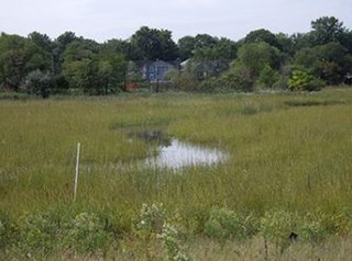
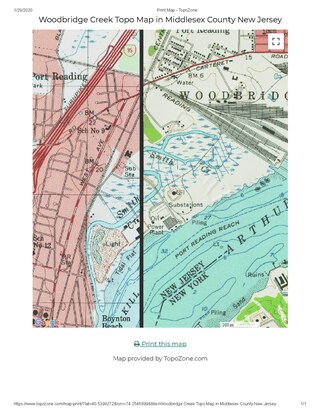
The Woodbrige River is a river in Woodbridge Township, Middlesex County, New Jersey, United States. The river is an important waterway, which frequently floods due to extreme weather caused by climate change, and is expected to increase doing so because of sea level rise. The river includes several conservation areas to protect the diversity of wildlife in the waterway, and the local government is increasingly buying out properties as part of a managed retreat to buffer other properties in the township.

Wedgewood Brook is a tributary of the Woodbridge River, located within Woodbrige Proper, Middlesex County, New Jersey, United States.

Pumpkin Patch Brook is a stream in Union and Middlesex counties in the U.S. state of New Jersey. It is a tributary of Robinson's Branch of the Rahway River.
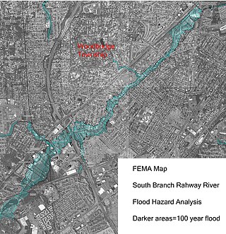
The South Branch Rahway River flows north north through Woodbridge Township, New Jersey before entering the Rahway River in Rahway, New Jersey, 4.5 miles from the Arthur Kill. Its source is the Roosevelt Park lake in Edison, New Jersey.
Smith Creek is a stream in Woodbridge Township, New Jersey, United States, emptying into the Arthur Kill 0.5 miles (0.80 km) north of the Woodbridge River. It was named for John Smith, one of the group who in 1667 purchased the land parcel from Governor Philip Carteret that became Woodbridge. Its navigable length is 0.6 miles (0.97 km), and there are nine marinas in that stretch. The creek draws less than 3 to 3.5 feet of water, limiting its use to shallow draft boats. Dredging of the creek in the region of the marinas was a 2013 priority for Woodbridge Township after Hurricane Sandy. The creek is a "minor freshwater tributary" to Arthur Kill, with higher flows in the spring, and less in late summer and fall. Public Service Enterprise Group has a generating station 0.6 miles (0.97 km) north of the mouth of Smith Creek. One mile north of the mouth is an oil refining and storage facility. In 2013 "corrective action" was taken against the Hess Corporation, after selling the property, for soil and groundwater contamination, including arsenic, lead and benzene. An old reference states:
Transatlantic sailing vessels once docked in Woodbridge, but silt from the clay pits converted Smith Creek into an inconsequential brook. Until the 1880s Woodbridge was a fashionable watering place. The Arthur Kill is now so spoiled by oil and sewage even gulls avoid it.
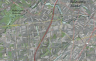
Robinsons Branch is a tributary of the Rahway River in Union and Middlesex Counties, New Jersey, United States.

Marshes Creek is a tidal tributary of the Rahway River in Linden, New Jersey, United States.


