Woodbridge River

Last updated
Woodbridge River
Woodbridge Creek
Tidal creek Woodbridge Marsh 2008.jpg
Tidal branch of Woodbridge River in Woodbridge marsh
Location
Country United States
StateNew Jersey
CityWoodbridge Township
Physical characteristics
SourceNortheast Woodbridge Township
Mouth Arthur Kill
Length5 mi (8.0 km)
Woodbridge River course in Woodbridge, New Jersey Print Map - TopoZonew.jpg
Woodbridge River course in Woodbridge, New Jersey
Woodbridge, New Jersey, area inundated by Woodbridge River after Hurricane Sandy (Source: USGS Sandy Storm Tide Mapper) Detailed-Descriptions-of-Woodbridge-Townships-Floodplains.jpg
Woodbridge, New Jersey, area inundated by Woodbridge River after Hurricane Sandy (Source: USGS Sandy Storm Tide Mapper)

The Woodbrige River (also known as Woodbridge Creek [1] ) is a river in Woodbridge Township, Middlesex County, New Jersey, United States. The river is an important waterway, which frequently floods due to extreme weather caused by climate change, and is expected to increase doing so because of sea level rise. The river includes several conservation areas to protect the diversity of wildlife in the waterway, and the local government is increasingly buying out properties as part of a managed retreat to buffer other properties in the township.

Contents

Geography

The Woodbridge River flows south 5 miles in Woodbridge Township emptying into the Arthur Kill. The headwaters are near Omar Avenue in the far northeast part of the township. It is a tidal river for three-fourths of its length, with brackish water below Homestead Avenue. It serves as a basin for about half of Woodbridge. Major tributaries include Heards Brook and Wedgewood Brook in Woodbrige Proper. [2]

Flooding

There is a long history of tidal flooding along this river and its major tributaries. [3] The most extreme flooding occurred during Superstorm Sandy, with a high water mark in the Woodbridge River of 12 feet; low-lying areas along the lower river have only a six-seven foot elevation above sea level. Woodbridge streams and rivers have been described as having a "high flow, flashy nature;" in addition to tidal flooding, fluvial flooding is also common. The land is relatively impervious, and flooding is exacerbated steep slopes and urban cover. Prolonged coastal storms (nor'easters), which combine tidal and fluvial flooding, along with flow constrictions, cause an increase in the duration of flooding of the Woodbridge River and its tributaries, which may last for days before water levels subside. Decadal events have the potential for four-foot flooding in lowest developed areas. [4] Frequency of flooding in these areas have increased over time. Residential areas moved into previous marsh land, decreasing the ability of the land to absorb excess water.

A 1770 map shows that all land surrounding the river was salt marshes. In the most affected area from Hurricane Sandy, Watson-Cramptom, prior to 2009 the area adjacent to the Woodbridge River was zoned for high density residential housing, including the area consisting of wetlands and meadows. [5] When the Sandy came it was "characterized as a tsunami-like water wall," destroying adjoining homes. [6] The Woodbridge River flood zone has become a part of the restoration plan for the riparian environment. [7]

After Sandy, using money from the New Jersey Buyout Program, [8] Woodbridge bought out and demolished many residential properties in the flood hazard areas. [9] Woodbridge's actions and plans have been called a "slow motion evacuation from climate change." As people move out of flood hazard areas, they will be replaced by a "floodplain forest of native trees, shrubs and grass." [10] In Woodbridge not everybody wants to sell; 2050, when the properties have a high probability of severe damage from rising sea levels, [11] seems too far in the future for some. [12] This interferes with the goal of land buffers, entire blocks, between rivers and homes. [13]

Land preservation

The Woodbridge River enters Arthur Kill, Shell oil plant in foreground THE WOODBRIDGE RIVER ENTERS ARTHUR KILL NEAR PERTH AMBOY SHELL OIL PLANT IN FOREGROUND - NARA - 551995.jpg
The Woodbridge River enters Arthur Kill, Shell oil plant in foreground

In 2013 the Ernest L. Oros Wildlife Preserve was dedicated; the Preserve occupies 99 acres along the Woodbridge River and has restored the river and adjacent land as a nature preserve. [14] [2]

Many bird species have been observed along the river, particularly at the Oros Preserve. Bird sightings include wading birds (great blue herons and great egrets), the bald eagle, belted kingfishers and Canada goose. Eight mammal species have been noted, including racoon and red fox; nine fish species have been identified, including the American eel. The Preserve has been called "an important hot spot in an otherwise highly developed area". [15] [16]

Downstream and north of Port Reading Avenue is Woodbridge River Park. It is 40 acres, and described as "loaded with channels, backwaters, oxbows and suitable for canoes." [17]

Related Research Articles

<span class="mw-page-title-main">Geography of Thailand</span>

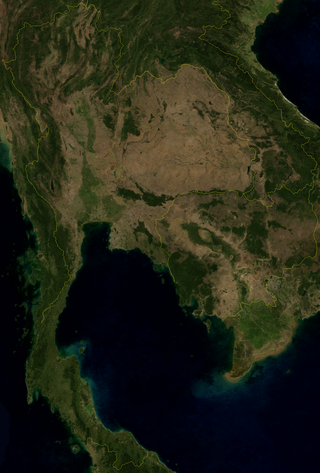
Thailand is in the middle of mainland Southeast Asia. It has a total size of 513,120 km2 (198,120 sq mi) which is the 50th largest in the world. The land border is 4,863 km (3,022 mi) long with Myanmar, Cambodia, Laos and Malaysia. The nation's axial position influenced many aspects of Thailand's society and culture. It controls the only land route from Asia to Malaysia and Singapore. It has an exclusive economic zone of 299,397 km2 (115,598 sq mi).

<span class="mw-page-title-main">Flood</span> Water overflow submerging usually-dry land

A flood is an overflow of water that submerges land that is usually dry. In the sense of "flowing water", the word may also be applied to the inflow of the tide. Floods are an area of study of the discipline hydrology and are of significant concern in agriculture, civil engineering and public health. Human changes to the environment often increase the intensity and frequency of flooding, for example land use changes such as deforestation and removal of wetlands, changes in waterway course or flood controls such as with levees, and larger environmental issues such as climate change and sea level rise. In particular climate change's increased rainfall and extreme weather events increases the severity of other causes for flooding, resulting in more intense floods and increased flood risk.

<span class="mw-page-title-main">Floodplain</span> Land adjacent to a river which is flooded during periods of high discharge

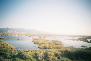
A floodplain or flood plain or bottomlands is an area of land adjacent to a river. Floodplains stretch from the banks of a river channel to the base of the enclosing valley, and experience flooding during periods of high discharge. The soils usually consist of clays, silts, sands, and gravels deposited during floods.

<span class="mw-page-title-main">Woodbridge Township, New Jersey</span> Township in Middlesex County, New Jersey, United States

Woodbridge Township is a township in northern Middlesex County, in the U.S. state of New Jersey. The township is a regional hub of transportation and commerce for central New Jersey and a major bedroom suburb of New York City, within the New York metropolitan area. Located within the core of the Raritan Valley region, Woodbridge Township hosts the junction of the New Jersey Turnpike and the Garden State Parkway, the two busiest highways in the state, and also serves as the headquarters for the New Jersey Turnpike Authority, which operates both highways.

<span class="mw-page-title-main">Raritan River</span> Major river in the U.S. state of New Jersey

The Raritan River is a major river of New Jersey. Its watershed drains much of the mountainous area of the central part of the state, emptying into the Raritan Bay on the Atlantic Ocean.

The National Flood Insurance Program (NFIP) is a program created by the Congress of the United States in 1968 through the National Flood Insurance Act of 1968. The NFIP has two purposes: to share the risk of flood losses through flood insurance and to reduce flood damages by restricting floodplain development. The program enables property owners in participating communities to purchase insurance protection, administered by the government, against losses from flooding, and requires flood insurance for all loans or lines of credit that are secured by existing buildings, manufactured homes, or buildings under construction, that are located in the Special Flood Hazard Area in a community that participates in the NFIP. U.S. Congress limits the availability of National Flood Insurance to communities that adopt adequate land use and control measures with effective enforcement provisions to reduce flood damages by restricting development in areas exposed to flooding.

<span class="mw-page-title-main">Flood control</span> Methods used to reduce or prevent the detrimental effects of flood waters

Flood control methods are used to reduce or prevent the detrimental effects of flood waters. Flood relief methods are used to reduce the effects of flood waters or high water levels. Flooding can be caused by a mix of both natural processes, such as extreme weather upstream, and human changes to waterbodies and runoff. A distinction is made between structural and non-structural flood control measures. Structural methods physically restrain the flood waters, whereas non-structural methods do not. Building hard infrastructure to prevent flooding, such as flood walls, is effective at managing flooding. However, increased best practice within landscape engineering is to rely more on soft infrastructure and natural systems, such as marshes and flood plains, for handling the increase in water. To prevent or manage coastal flooding, coastal management practices have to handle natural processes like tides but also the human-caused sea level rise.

<span class="mw-page-title-main">Winter flooding of 2013–14 on the Somerset Levels</span> Flooding in Somerset, England

From December 2013 onwards the Somerset Levels suffered severe flooding as part of the wider 2013–2014 Atlantic winter storms in Europe and subsequent 2013–2014 United Kingdom winter floods. The Somerset Levels, or the Somerset Levels and Moors as they are less commonly but more correctly known, is a coastal plain and wetland area of central Somerset, in South West England, running south from the Mendip Hills to the Blackdown Hills.

<span class="mw-page-title-main">Meshchyorsky National Park</span>

Meshchyorsky National Park covers extensive wetlands and pine/birch woodlands in the Meshchera Lowlands on the East European Plain in the northern section of Ryazan Oblast, Russia, about 120 km east of Moscow. The wetland habitat provides for extremely rich biodiversity among the plants and animals. "Meshchersky" (Мещёрский) National Park is not to be confused with "Meshchyora" (Мещёра) National Park, which is just to the north, over the border in Vladimir Oblast. The park protects a section of the Pra River, Lake Beloye, and associated wetlands and forests. About 54% of the park territory is used and managed for agricultural purposes by local communities.

<span class="mw-page-title-main">New York Harbor Storm-Surge Barrier</span> Proposed barrier/floodgate system to protect New York metro area

The New York Harbor Storm-Surge Barrier is a proposed flood barrier system to protect the New York-New Jersey Harbor Estuary from storm surges. The proposed system would consist of one barrier located across the mouth of Lower New York Bay, possibly between Sandy Hook (N.J.) and Rockaway (N.Y.), and a second on the upper East River to provide a ring of protection to most of the bi-state region. Through extensive use of floodgates, both barriers would have largely open cross-sections during normal conditions to minimize environmental impacts on the estuary and port operations.

<span class="mw-page-title-main">Sea Bright–Monmouth Beach Seawall</span> Seawall in New Jersey

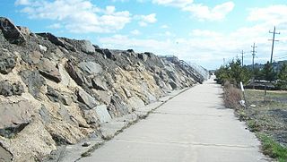
The Sea Bright–Monmouth Beach Seawall is a seawall located along the Jersey Shore in the Monmouth County, New Jersey towns of Sea Bright and Monmouth Beach. It roughly runs north-south direction along 4.7 miles (7.6 km) of the barrier spit of land along the lower Sandy Hook peninsula between the Atlantic Ocean and the Shrewsbury River estuary. The use of seawalls, groins, jetties, bulkheads, revetment, and beach nourishment since the late 1800s has made the stretch of coast one of the most heavily engineered sections of ocean shorefront in the world.

<span class="mw-page-title-main">Climate change in Delaware</span> Climate change in the US state of Delaware

Climate change in Delaware encompasses the effects of climate change, attributed to man-made increases in atmospheric carbon dioxide, in the U.S. state of Delaware.

<span class="mw-page-title-main">Climate change in Virginia</span> Climate change in the US state of Virginia

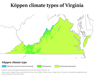
Climate change in Virginia encompasses the effects of climate change, attributed to man-made increases in atmospheric carbon dioxide, in the U.S. state of Virginia.

<span class="mw-page-title-main">Climate change in New Jersey</span> Climate change in the US state of New Jersey

Climate change in New Jersey is of concern due to its effects on the ecosystem, economy, infrastructure, and people of the U.S. state of New Jersey. According to climatology research by the U.S. National Oceanic and Atmospheric Administration, New Jersey has been the fastest-warming state by average air temperature over a 100-year period beginning in the early 20th century, related to global warming.

<span class="mw-page-title-main">Heards Brook</span>

Heards Brook is a stream in Woodbridge Township, Middlesex County, New Jersey, United States.

<span class="mw-page-title-main">Wedgewood Brook</span>

Wedgewood Brook is a tributary of the Woodbridge River, located within Woodbrige Proper, Middlesex County, New Jersey, United States.

<span class="mw-page-title-main">Pumpkin Patch Brook</span> Stream in Union and Middlesex Counties, New Jersey, U.S.

Pumpkin Patch Brook is a stream in Union and Middlesex counties in the U.S. state of New Jersey. It is a tributary of Robinson's Branch of the Rahway River.

<span class="mw-page-title-main">South Branch Rahway River</span>

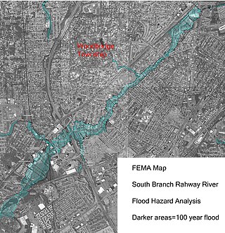
The South Branch Rahway River flows north north through Woodbridge Township, New Jersey before entering the Rahway River in Rahway, New Jersey, 4.5 miles from the Arthur Kill. Its source is the Roosevelt Park lake in Edison, New Jersey.

<span class="mw-page-title-main">Marshes Creek</span> Tidal tributary in Linden, New Jersey, US

Marshes Creek is a tidal tributary of the Rahway River in Linden, New Jersey, United States.

<span class="mw-page-title-main">Sedimentation enhancing strategy</span>

Sedimentation enhancing strategies are environmental management projects aiming to restore and facilitate land-building processes in deltas. Sediment availability and deposition are important because deltas naturally subside and therefore need sediment accumulation to maintain their elevation, particularly considering increasing rates of sea-level rise. Sedimentation enhancing strategies aim to increase sedimentation on the delta plain primarily by restoring the exchange of water and sediments between rivers and low-lying delta plains. Sedimentation enhancing strategies can be applied to encourage land elevation gain to offset sea-level rise. Interest in sedimentation enhancing strategies has recently increased due to their ability to raise land elevation, which is important for the long-term sustainability of deltas.

References

  1. "Woodbridge Creek". Geographic Names Information System . United States Geological Survey, United States Department of the Interior . Retrieved March 11, 2020.
  2. 1 2 "WRW-History and Facts". www.woodbridgeriverwatch.org. Retrieved 2020-01-22.
  3. "Special Flood Hazard Zone" (PDF). nj.gov/dca. 2014. Retrieved January 22, 2020.
  4. "Woodbridge floodplain plan". woodbridge.nj.us.
  5. Heyer, Gruel and Associates (2015). "Watson-Crampton Plan". twp.woodbridge.nj.us. Retrieved January 22, 2020.
  6. "Woodbridge tsunami-like water wall". PIG Difference. Retrieved 2020-01-19.
  7. "NJDEP-Office of Natural Resource Restoration". www.state.nj.us. Retrieved 2020-01-22.
  8. Schwartz, Jen (August 1, 2018). "Surrendering to rising seas". Scientific American. Retrieved January 22, 2020.
  9. "Open space flood plan" (PDF). lowerraritanwatershed.org. Retrieved January 15, 2020.
  10. "Evacuation from climate change". usnews.com. December 23, 2019.
  11. Sustainable New Jersey (2016-04-04). "Woodbridge vulnerability to rising sea levels" (PDF). Retrieved January 25, 2020.
  12. "New Jersey Tearing Down Homes In Towns Projected To Be Underwater In Coming Decades As Global Sea Levels Rise". 2019-12-23. Retrieved 2020-01-23.
  13. Flavelle, Christopher (August 22, 2016). "A new strategy for climate change". Bloomberg. Retrieved January 22, 2020.
  14. "Restoration of Woodbridge marshes". response.restoration.noaa.gov. Retrieved January 15, 2020.
  15. "Rutgers floodplain management plan" (PDF). Retrieved January 22, 2020. .
  16. Kerwin, Kathleen (June 21, 2017). "Bio blitz" (PDF). Rutgers University. Retrieved January 22, 2020.
  17. MacCracken, Jim. Middlesex County Fishing and Floating Guidebook. Bremen, Ohio: Recreation Guides.

40°32′23″N74°15′17″W / 40.5398°N 74.2546°W / 40.5398; -74.2546