
A flood is an overflow of water that submerges land that is usually dry. In the sense of "flowing water", the word may also be applied to the inflow of the tide. Floods are of significant concern in agriculture, civil engineering and public health. Human changes to the environment often increase the intensity and frequency of flooding. Examples for human changes are land use changes such as deforestation and removal of wetlands, changes in waterway course or flood controls such as with levees. Global environmental issues also influence causes of floods, namely climate change which causes an intensification of the water cycle and sea level rise. For example, climate change makes extreme weather events more frequent and stronger. This leads to more intense floods and increased flood risk.

A floodplain or flood plain or bottomlands is an area of land adjacent to a river. Floodplains stretch from the banks of a river channel to the base of the enclosing valley, and experience flooding during periods of high discharge. The soils usually consist of clays, silts, sands, and gravels deposited during floods.
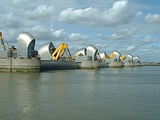
The Thames Barrier is a retractable barrier system built to protect the floodplain of most of Greater London from exceptionally high tides and storm surges moving up from the North Sea. It has been operational since 1982. When needed, it is closed (raised) during high tide; at low tide, it can be opened to restore the river's flow towards the sea. Built about 2 miles east of the Isle of Dogs, its northern bank is in Silvertown in the London Borough of Newham and its southern bank is in the New Charlton area of the Royal Borough of Greenwich.

Woodbridge Township is a township in northern Middlesex County, in the U.S. state of New Jersey. The township is a regional hub of transportation and commerce for central New Jersey and a major bedroom suburb of New York City, within the New York metropolitan area. Located within the core of the Raritan Valley region, Woodbridge Township hosts the junction of the New Jersey Turnpike and the Garden State Parkway, the two busiest highways in the state, and also serves as the headquarters for the New Jersey Turnpike Authority, which operates both highways.

The Raritan River is a river of the U.S. state of New Jersey. Its watershed drains much of the central region of the state, emptying into the Raritan Bay near Staten Island on the Atlantic Ocean.

The Kobuk River, also known by the names Kooak, Kowak, Kubuk, Kuvuk, and Putnam, is a river located in the Arctic region of northwestern Alaska in the United States. It is approximately 280 miles (451 km) long. Draining a basin with an area of 12,300 square miles (32,000 km2), the Kobuk River is among the largest rivers in northwest Alaska, with widths of up to 1,500 feet and flows reaching speeds of 3–5 miles per hour in its lower and middle reaches. The average elevation for the Kobuk River Basin is 1,300 feet (400 m) above sea level, ranging from sea level at its mouth on the Bering Sea to 11,400 feet near its headwaters in the Brooks Range.
The River Lee is a river in Ireland. It rises in the Shehy Mountains on the western border of County Cork and flows eastwards through Cork, where it splits in two for a short distance, creating an island on which Cork's city centre is built, then passing through Cork Harbour on the south coast, one of the largest natural harbours in the world, to empty into the Celtic Sea. The catchment area of the River Lee is 1,253 km2. The long-term average flow rate of the River Lee is 40.4 cubic metres per second (m3/s)

The Oyster River is a 17-mile-long (27 km) river in Strafford County, southeastern New Hampshire, United States. It rises in Barrington, flows southeast to Lee, then east-southeast in a serpentine course past Durham to meet the entrance of Great Bay into Little Bay. The bays are tidal inlets of the Atlantic Ocean, to which they are connected by a tidal estuary, the Piscataqua River. The freshwater portion of the river is 14.1 miles (22.7 km) long, and the tidal river extends 2.9 miles (4.7 km) from Durham to Great Bay.

A stream is a continuous body of surface water flowing within the bed and banks of a channel. Depending on its location or certain characteristics, a stream may be referred to by a variety of local or regional names. Long, large streams are usually called rivers, while smaller, less voluminous and more intermittent streams are known as streamlets, brooks or creeks.

Flood management describes methods used to reduce or prevent the detrimental effects of flood waters. Flooding can be caused by a mix of both natural processes, such as extreme weather upstream, and human changes to waterbodies and runoff. Flood management methods can be either of the structural type and of the non-structural type. Structural methods hold back floodwaters physically, while non-structural methods do not. Building hard infrastructure to prevent flooding, such as flood walls, is effective at managing flooding. However, it is best practice within landscape engineering to rely more on soft infrastructure and natural systems, such as marshes and flood plains, for handling the increase in water.

The Yanga National Park is a newly formed national park, located near the township of Balranald in south- western New South Wales. It covers an area of 66,734 hectares which includes 1,932 hectares of Yanga Nature Reserve, and has a frontage of 170 kilometres (110 mi) on the Murrumbidgee River. It is largely located in the Lower Murrumbidgee Floodplain, which is included on A Directory of Important Wetlands in Australia because of its importance as a breeding site for waterbirds when flooded.
A várzea forest is a seasonal floodplain forest inundated by whitewater rivers that occurs in the Amazon biome. Until the late 1970s, the definition was less clear and várzea was often used for all periodically flooded Amazonian forests.
Legacy sediment (LS) is depositional bodies of sediment inherited from the increase of human activities since the Neolithic. These include a broad range of land use and land cover changes, such as agricultural clearance, lumbering and clearance of native vegetation, mining, road building, urbanization, as well as alterations brought to river systems in the form of dams and other engineering structures meant to control and regulate natural fluvial processes (erosion, deposition, lateral migration, meandering). The concept of LS is used in geomorphology, ecology, as well as in water quality and toxicological studies.

A tidal strait is a strait connecting two oceans or seas through which a tidal current flows. Tidal currents are usually unidirectional but sometimes are bidirectional. Tidal straits, though they are narrow seaways, are technically not rivers. They are frequently of tectonic origin. In them, currents develop because of elevation differences between the water basins at both ends.

Heards Brook is a stream in Woodbridge Township, Middlesex County, New Jersey, United States.
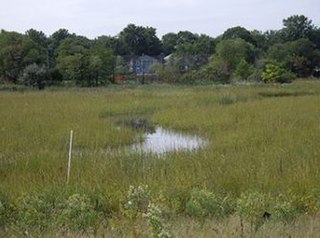
The Woodbrige River is a river in Woodbridge Township, Middlesex County, New Jersey, United States. The river is an important waterway, which frequently floods due to extreme weather caused by climate change, and is expected to increase doing so because of sea level rise. The river includes several conservation areas to protect the diversity of wildlife in the waterway, and the local government is increasingly buying out properties as part of a managed retreat to buffer other properties in the township.

Pumpkin Patch Brook is a stream in Union and Middlesex counties in the U.S. state of New Jersey. It is a tributary of Robinson's Branch of the Rahway River.
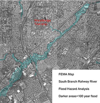
The South Branch Rahway River flows north north through Woodbridge Township, New Jersey before entering the Rahway River in Rahway, New Jersey, 4.5 miles from the Arthur Kill. Its source is the Roosevelt Park lake in Edison, New Jersey.

A hapua is a river-mouth lagoon on a mixed sand and gravel (MSG) beach, formed at the river-coast interface where a typically braided, although sometimes meandering, river interacts with a coastal environment that is significantly affected by longshore drift. The lagoons which form on the MSG coastlines are common on the east coast of the South Island of New Zealand and have long been referred to as hapua by Māori people. This classification differentiates hapua from similar lagoons located on the New Zealand coast termed waituna.
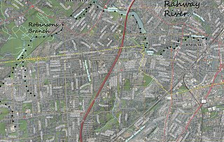
Robinsons Branch is a tributary of the Rahway River in Union and Middlesex Counties, New Jersey, United States.

