Established on October 10, 1667 by the Connecticut General Assembly, Wallingford was founded by a group of 38 planters and freemen. These early settlers chose a strategic location near the Quinnipiac River, which is now the area known as Main Street. By May 12, 1670, the settlement had grown to include 126 residents living in temporary housing, and by 1675, 40 permanent homes had been constructed.
One of Wallingford's early settlers was Thomas Yale, an influential figure in the New Haven Colony and an ancestor of Elihu Yale, the benefactor after whom Yale University is named. Thomas Yale was a signatory of the Wallingford plantation covenant in 1667, marking the formal establishment of the town.
In 1697, the town became the site of Connecticut's last witchcraft trial when Winifred Benham and her teenage daughter were accused of witchcraft.[4]
Born in Wallingford in 1724, Lyman Hall went on to become a prominent physician and statesman. Although he was born in Connecticut, he represented Georgia in the Continental Congress. Hall was one of the signers of the Declaration of Independence.
As Wallingford entered the 19th century, it began to transform from an agricultural community into an industrial hub. The arrival of the railroad in the 1840s, specifically the New Haven and Hartford Railroad (later part of the New York, New Haven, and Hartford Railroad), further accelerated the town's growth.
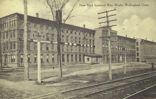
Wallingford became particularly renowned for its silver production, with companies like Hall, Elton & Co., Simpson, Hall, Miller & Co., and R. Wallace & Sons gaining national prominence. One of the key figures in this industry was Samuel Simpson, a local industrialist and philanthropist who played a pivotal role in Wallingford's rise as a center of silver manufacturing. Simpson, Hall, Miller & Co., which he co-founded, became one of the leading producers of silverware in the country. Samuel Simpson's contributions were instrumental in establishing Wallingford as a major hub for silver production. His company eventually became part of the International Silver Company, headquartered in the neighboring city of Meriden.
In the 19th century, Wallingford was also the birthplace of Moses Yale Beach, a prominent figure in American journalism. Born in 1800, Beach became the owner of the New York Sun and was known for pioneering the "penny press," making newspapers affordable to the general public. He is also credited for being a leading founder of the Associated Press.
However, Wallingford was not immune to tragedy. On August 9, 1878, a devastating tornado struck the town, leaving a path of destruction and claiming the lives of at least 34 and injuring 70 or more residents. This tornado remains the deadliest in Connecticut's history.[5]
The post-World War II era saw significant growth in Wallingford's population, driven by the suburban boom that reshaped much of America. Despite the suburbanization, Wallingford continued to attract businesses, maintaining a robust economic base. The town became a hub for various industries, including medical, healthcare, high-tech specialty manufacturing, and research and development. The development of several industrial parks including Barnes Industrial Park, Casimir Pulaski Industrial Park, Centract Park, and MedWay Industrial Park—helped attract a wide range of businesses, further diversifying Wallingford's tax base. The establishment of an Interchange Zone at the intersection of Interstate 91 and Route 68 facilitated the growth of office parks, research centers, and hotels, cementing Wallingford's role as a key economic center in the region.[citation needed]
One of the most significant industrial presences in Wallingford during the late 20th and early 21st centuries was the Bristol-Myers Squibb Company. The pharmaceutical giant established a research and development facility in Wallingford's MedWay Industrial Park, becoming the town's largest taxpayer and a key contributor to its economy. However, in 2017, Bristol-Myers Squibb relocated its operations, and the facility was subsequently demolished in 2018.[6]
Wallingford is served by the Wallingford Public School District, which includes several elementary schools, two middle schools (Dag Hammarskjold and James H. Moran), and two high schools (Mark T. Sheehan and Lyman Hall). The district offers a range of academic programs, including Advanced Placement courses, STEM education, and arts programs. Lyman Hall High School features a specialized agricultural science program. The district also provides special education services, English language learning programs, and a variety of sports programs, including football, soccer, basketball, and track and field.[7]
Choate Rosemary Hall Campus
Private schools
Wallingford is also home to three private schools:
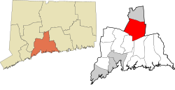
According to the United States Census Bureau, the town has a total area of 39.9square miles (103.3km2), of which 39.0square miles (101.1km2) is land and 0.9square miles (2.2km2), or 2.16%, is water.
As of 2022, Wallingford is home to approximately 44,446 residents. The racial makeup leans white (80.2%), with a notable Hispanic presence (11.6%) and smaller proportions of Asian (4.4%) and other groups. The median age sits at 44.3, indicating a blend of families and young professionals. Family households comprise 63% of the total, with 24% having children under their roof.[11]
Wallingford's 2024 median household income was $104,773, and the median family income was $126,165.[12] The average household and family income was $128,544 and $153,168 respectively.[13] Compared to the national average, Wallingford's median income is significantly higher, putting it in the top 10% of U.S. households.
Economy
Top employers
Top employers in Wallingford according to the town's 2022 Comprehensive Annual Financial Report:[14]
The Wallingford Electric Division (WED) is a municipally owned utility that provides electricity to the town. Established in 1899, WED is one of Connecticut's few municipal electric utilities, operating under the town's governance. The Wallingford Electric Division is overseen by the Public Utilities Commission of Wallingford, which manages its operations, finances, and strategic planning.
Moses Yale Beach, American inventor, entrepreneur, philanthropist and publisher, who started the Associated Press, and is credited with originating print syndication
This page is based on this Wikipedia article Text is available under the CC BY-SA 4.0 license; additional terms may apply. Images, videos and audio are available under their respective licenses.