Somers, Connecticut

Last updated • 6 min readFrom Wikipedia, The Free Encyclopedia

Somers, Connecticut
Town of Somers
Free Public Library, Somers CT.jpg
Free Public Library
SomersCTseal.JPG
Tolland County Connecticut Incorporated and Unincorporated areas Somers Highlighted 2010.svg
Capitol Region incorporated and unincorporated areas Somers highlighted.svg
Somers, Connecticut
Somers, Connecticut
Somers, Connecticut
Coordinates: 41°59′N72°27′W / 41.983°N 72.450°W / 41.983; -72.450
CountryFlag of the United States.svg  United States
U.S. state Flag of Connecticut.svg  Connecticut
County Tolland
Region Capitol Region
Settled1689
Named1734
Annexed by Connecticut1749
Government
  Type Selectman-town meeting
  First selectmanTimothy Keeney (R)
  SelectmanWilliam Meier III (R)
  SelectmanRobert Schmidt (D)
Area
  Total28.5 sq mi (73.8 km2)
  Land28.3 sq mi (73.4 km2)
  Water0.1 sq mi (0.3 km2)
Elevation
240 ft (73 m)
Population
 (2020)
  Total10,255
  Density360/sq mi (140/km2)
Time zone UTC-5 (Eastern)
  Summer (DST) UTC-4 (Eastern)
ZIP Code
06071
Area code(s) 860/959
FIPS code 09-69220
GNIS feature ID0212346
Website www.somersct.gov

Somers ( /ˈsʌmərs/ SUM-ərss) is a town in Tolland County, Connecticut, United States. The town is part of the Capitol Planning Region. The population was 10,255 at the 2020 census. [1] The town center is listed by the U.S. Census Bureau as a census-designated place (CDP). In 2007, Money Magazine listed Somers 53rd on its "100 Best Places to Live", based on "economic opportunity, good schools, safe streets, things to do and a real sense of community."

Contents

Bordering Massachusetts, Somers is considered part of the city of Springfield NECTA. Somers is 13 miles (21 km) southeast of Springfield and considered more oriented toward it [ citation needed ] than the city of Hartford, which lies 22 miles (35 km) to the southwest.

History

Somers was originally part of the Agawam Plantation in the 17th century. Agawam Plantation became Springfield, Massachusetts, in 1641 and in 1682, the Enfield Parish broke off from the Springfield settlement. In 1689, the first settler, Benjamin Jones, came to Somers in what was then East Enfield about a half mile from the current town center, it was only a summer house and in the winter, he and his family returned to Enfield. [2] [3] In 1711, several more families settled the Somers area to help start a village. The families of Kibbe, Pease, Root, and Megregory were the first to settle the area. The Village was given the name Wallop but was changed to East Enfield shortly after. In the year 1734, East Enfield became a town and was renamed Somers, after John Somers, 1st Baron Somers. [4] In the year 1749, Somers joined the Connecticut Colony.

The Four Town Fair, which is usually held after the third weekend in September, is one of the oldest fairs in the country. [5]

Little Sorrel, the favorite horse of Confederate general Stonewall Jackson, was born at a farm in Somers. [6] [7]

Geography

Somers is at 41°59′N72°27′W / 41.983°N 72.450°W / 41.983; -72.450 . [8]

According to the United States Census Bureau, the town has a total area of 28.5 square miles (74 km2), of which 28.3 square miles (73 km2) is land and 0.1 square miles (0.26 km2) (0.49%) is water. The town center CDP has a total area of 2.1 square miles (5.4 km2), all land.

The town's highest point, Bald Mountain, at 1,121 feet (342 m) is the highest point along the Connecticut River Valley in Connecticut. The rounded hill summit was recently purchased by the town and can be seen for many miles around.

Neighborhoods

Demographics

Historical population
CensusPop.Note
1820 1,306
1850 1,508
1860 1,5170.6%
1870 1,247−17.8%
1880 1,242−0.4%
1890 1,40713.3%
1900 1,59313.2%
1910 1,6533.8%
1920 1,6731.2%
1930 1,91714.6%
1940 2,11410.3%
1950 2,63124.5%
1960 3,70240.7%
1970 6,89386.2%
1980 8,47322.9%
1990 9,1087.5%
2000 10,41714.4%
2010 11,4449.9%
2020 10,255−10.4%
U.S. Decennial Census [9]

As of the census [10] of 2000, there were 10,417 people, 2,925 households, and 2,337 families living in the town. The population density was 367.6 inhabitants per square mile (141.9/km2). There were 3,012 housing units at an average density of 106.3 per square mile (41.0/km2). The racial makeup of the town was 82.97% White, 9.82% African American, 0.55% Native American, 0.62% Asian, 0.06% Pacific Islander, 4.00% from other races, and 1.98% from two or more races. Hispanic or Latino of any race were 8.10% of the population.

There were 2,925 households, out of which 37.0% had children under the age of 18 living with them, 70.4% were married couples living together, 6.7% had a female householder with no husband present, and 20.1% were non-families. 16.0% of all households were made up of individuals, and 8.4% had someone living alone who was 65 years of age or older. The average household size was 2.78 and the average family size was 3.11.

In the town, the population was spread out, with 20.8% under the age of 18, 9.4% from 18 to 24, 35.6% from 25 to 44, 24.0% from 45 to 64, and 10.1% who were 65 years of age or older. The median age was 37 years. For every 100 females, there were 154.6 males. For every 100 females age 18 and over, there were 171.0 males.

The median income for a household in the town was $65,273, and the median income for a family was $71,757. Males had a median income of $49,766 versus $35,329 for females. The per capita income for the town was $23,952. About 3.7% of families and 4.6% of the population were below the poverty line, including 3.3% of those under age 18 and 3.8% of those age 65 or over.

Town center

As of the census [10] of 2000, there were 1,626 people, 628 households, and 457 families living in the town center CDP. The population density was 777.3 inhabitants per square mile (300.1/km2). There were 645 housing units at an average density of 308.3 per square mile (119.0/km2). The racial makeup of the CDP was 98.15% White, 0.18% African American, 0.55% Asian, 0.06% Pacific Islander, 0.12% from other races, and 0.92% from two or more races. Hispanic or Latino of any race were 1.05% of the population.

There were 628 households, out of which 31.1% had children under the age of 18 living with them, 63.2% were married couples living together, 7.3% had a female householder with no husband present, and 27.2% were non-families. 23.7% of all households were made up of individuals, and 14.8% had someone living alone who was 65 years of age or older. The average household size was 2.59 and the average family size was 3.05.

In the CDP the population was spread out, with 24.3% under the age of 18, 5.6% from 18 to 24, 26.9% from 25 to 44, 26.4% from 45 to 64, and 16.8% who were 65 years of age or older. The median age was 41 years. For every 100 females, there were 96.1 males. For every 100 females age 18 and over, there were 89.7 males.

The median income for a household in the CDP was $54,625, and the median income for a family was $64,107. Males had a median income of $45,893 versus $31,736 for females. The per capita income for the CDP was $24,874. About 4.0% of families and 6.8% of the population were below the poverty line, including 11.1% of those under age 18 and 7.5% of those age 65 or over.

Government and infrastructure

Two Connecticut Department of Corrections prisons, Northern Correctional Institution and Osborn Correctional Institution, [11] [12] are in Somers. [13] Northern housed the state's death row for men. [11] Osborn housed the state's execution chamber. [14]

Education

The Town of Somers is served by three schools, all located within the Somers Public School District. Somers Elementary School serves grades Pre-K through 5, Mabelle B. Avery Middle School, named CAS 2024 Middle School of the Year, [15] serves grades 6 through 8, and Somers High School serves grades 9 through 12. The district also houses the town's public library. [16]

Recreation

The Town of Somers maintains several recreation facilities, the largest being the facility on Field Road which features a pavilion, playscape, tennis courts and ball fields. [17] The Shenipsit State Forest along with the Shenipsit Trail is also partially in Somers, along with Soapstone Mountain, the highest point in the state forest. [18] The Scantic River State Park is also partially in Somers. [19] The Northern Connecticut Land Trust also has several properties in town. [20]

Notable people

Related Research Articles

<span class="mw-page-title-main">Hampshire County, Massachusetts</span> County in Massachusetts, United States

Hampshire County is a historical and judicial county located in the U.S. state of Massachusetts. As of the 2020 census, the population was 162,308. Its most populous municipality is Amherst, its largest town in terms of landmass is Belchertown, and its traditional county seat is Northampton. The county is named after the county Hampshire, in England. Hampshire County is part of the Springfield, MA Metropolitan Statistical Area. Together with Hampden County, Hampshire County municipalities belong to the Pioneer Valley Planning Commission.

<span class="mw-page-title-main">Hazardville, Connecticut</span> Census-designated place in Connecticut, United States

Hazardville is a section of the town of Enfield, Connecticut, United States, in Hartford County. It is a census-designated place (CDP) that had a total population of 4,599 as of the 2010 census.

<span class="mw-page-title-main">Sherwood Manor, Connecticut</span> Census-designated place in Connecticut, United States

Sherwood Manor is a census-designated place (CDP) within the town of Enfield in Hartford County, Connecticut, United States. The population was 5,410 at the 2010 census.

<span class="mw-page-title-main">Tariffville, Connecticut</span> Census-designated place in Connecticut, United States

Tariffville is a neighborhood and census-designated place (CDP) in the town of Simsbury in Hartford County, Connecticut, United States. The population was 1,324 at the 2010 census. It is a popular location for whitewater paddlers who use the Farmington River.

<span class="mw-page-title-main">Thompsonville, Connecticut</span> Census-designated place in Connecticut, United States

Thompsonville is a census-designated place (CDP) in the town of Enfield in Hartford County, Connecticut, United States. The population of the CDP was 8,577 at the 2010 census.

<span class="mw-page-title-main">Westbrook, Connecticut</span> Town in Connecticut, United States

Westbrook is a town in Middlesex County, Connecticut, United States. The town is part of the Lower Connecticut River Valley Planning Region. The population was 6,769 at the 2020 census. The town center is classified by the U.S. Census Bureau as a census-designated place (CDP).

<span class="mw-page-title-main">Poquonock Bridge, Connecticut</span> Census-designated place in Connecticut, United States

Poquonock Bridge is a village and census-designated place (CDP) in the town of Groton in New London County, Connecticut, United States. The population was 1,686 at the 2020 census.

<span class="mw-page-title-main">Simsbury Center, Connecticut</span> Census-designated place in Connecticut, United States

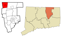
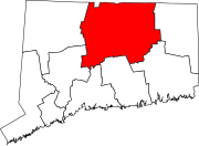
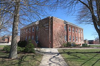
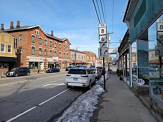
Simsbury Center is a census-designated place (CDP) that consists of the central settlement, and the neighborhoods immediately surrounding it, in the town of Simsbury, Connecticut, United States. As of the 2010 census, the CDP had a population of 5,836. The core area of the CDP is listed as the Simsbury Center Historic District on the National Register of Historic Places.

<span class="mw-page-title-main">Southwood Acres, Connecticut</span> Census-designated place in Connecticut, United States

Southwood Acres is a suburban neighborhood within the town of Enfield in northern Hartford County, Connecticut, United States. The neighborhood is listed as a census-designated place (CDP) by the U.S. Census Bureau and had a population of 7,657 at the 2010 census.

<span class="mw-page-title-main">Putnam (CDP), Connecticut</span> Census-designated place in Connecticut, United States

Putnam District is a village and census-designated place (CDP) in Windham County, Connecticut, United States. The CDP was formed when the former city of Putnam disincorporated, and it consists of the main town center of the town of Putnam along the Quinebaug River. The village is part of the Northeastern Connecticut Planning Region. The population was 7,214 at the 2010 census.

<span class="mw-page-title-main">Northridge, Clark County, Ohio</span> Census-designated place in Ohio, United States

Northridge is a census-designated place (CDP) in Clark County, Ohio, United States. The population was 7,518 at the 2020 census. It is part of the Springfield, Ohio Metropolitan Statistical Area.

<span class="mw-page-title-main">Ridgefield (CDP), Connecticut</span> Census-designated place in Connecticut, United States

Ridgefield is a census-designated place (CDP) in Fairfield County, Connecticut, United States. It consists of the primary central village in the town of Ridgefield and surrounding residential areas. As of the 2020 census, the population of the CDP was 7,596, out of 25,053 in the entire town.

<span class="mw-page-title-main">Hatfield (CDP), Massachusetts</span> Census-designated place in Massachusetts, United States

Hatfield is a census-designated place (CDP) comprising the main village in the town of Hatfield in Hampshire County, Massachusetts, United States. The population of the CDP was 1,318 at the 2010 census, out of a total town population of 3,279. It is part of the Springfield, Massachusetts Metropolitan Statistical Area.

Lancaster is a census-designated place (CDP) and the main village in the town of Lancaster in Coos County, New Hampshire, United States. The population of the CDP was 1,941 at the 2020 census, out of 3,218 in the entire town of Lancaster.

Enfield is a census-designated place (CDP) and the main village in the town of Enfield in Grafton County, New Hampshire, United States. The population of the CDP was 1,571 at the 2020 census, out of 4,465 in the entire town.

<span class="mw-page-title-main">Springfield (CDP), Vermont</span> Census-designated place in Vermont, United States

Springfield is a census-designated place (CDP) comprising the main settlement within the town of Springfield, Windsor County, Vermont, United States. The population of the CDP was 3,979 at the 2010 census, compared with 9,373 for the town as a whole.

<span class="mw-page-title-main">Bethlehem Village, Connecticut</span> Census-designated place in Connecticut, United States

Bethlehem Village is a census-designated place (CDP) within the town of Bethlehem in Litchfield County, Connecticut, United States. The CDP includes the Bethlehem Green Historic District at the town center, as well as surrounding residential and rural land. As of the 2010 census, the CDP had a population of 2,021, out of a population of 3,607 for the entire town of Bethlehem.

<span class="mw-page-title-main">Greenwich (CDP), Connecticut</span> Census-designated place in Connecticut, United States

Greenwich is a census-designated place (CDP) in Fairfield County, Connecticut, United States. It is one of several CDPs within the town of Greenwich and corresponds to the historic municipal center of the town and surrounding residential and commercial areas. As of the 2010 census, the population of the Greenwich CDP was 12,942, out of 61,171 in the entire town.

<span class="mw-page-title-main">Watertown (CDP), Connecticut</span> Census-designated place in Connecticut, United States

Watertown is a census-designated place (CDP) in Litchfield County, Connecticut, United States. It comprises the central village of the town of Watertown. As of the 2010 census, the population of the CDP was 3,574, out of 22,514 in the entire town. As of the 2020 Census, the population was 22,105.

<span class="mw-page-title-main">Thomaston (CDP), Connecticut</span> Census-designated place in Connecticut, United States

Thomaston is a census-designated place (CDP) in Litchfield County, Connecticut, United States. It comprises the downtown portion of the town of Thomaston. As of the 2010 census, the population of the CDP was 1,910, out of 7,887 in the entire town.

References

  1. "Census - Geography Profile: Somers town, Tolland County, Connecticut" . Retrieved December 21, 2021.
  2. "Historical sketch of the town of Enfield".
  3. "Benjamin Jones, of Somers & Enfield". March 28, 2020.
  4. The Connecticut Magazine: An Illustrated Monthly. Connecticut Magazine Company. 1903. p. 334.
  5. "Four Town Fair History".
  6. "City of Somers, CT". Archived from the original on April 4, 2014. Retrieved April 27, 2014.
  7. "Little Sorrel, Connecticut's Confederate War Horse". ConnecticutHistory.org. Retrieved September 12, 2013.
  8. "US Gazetteer files: 2010, 2000, and 1990". United States Census Bureau. February 12, 2011. Retrieved April 23, 2011.
  9. "Census of Population and Housing". Census.gov. Retrieved June 4, 2015.
  10. 1 2 "U.S. Census website". United States Census Bureau . Retrieved January 31, 2008.
  11. 1 2 "Northern Correctional Institution." Connecticut Department of Correction. Retrieved on August 16, 2010.
  12. "Osborne Correctional Institution." Connecticut Department of Correction. Retrieved on August 16, 2010.
  13. "Somers town, Connecticut Archived 2011-06-08 at the Wayback Machine ." U.S. Census Bureau. Retrieved on August 16, 2010.
  14. "Administration of Capital Punishment Directive Number 6.15." Connecticut Department of Correction. October 19, 2004. 1/9. Retrieved on August 16, 2010. "Execution Area. A series of four (4) contiguous rooms in the Osborn Correctional Institution ..."
  15. "Connecticut Association of Schools - Serving Students » CAS Names 2024 Schools of the Year".
  16. "Home". www.somers.k12.ct.us. Retrieved January 16, 2023.
  17. "Town of Somers Recreation - Somers Recreation Department".
  18. "Shenipsit State Forest".
  19. "Other State Parks and Forests".
  20. "Somers CT Properties". www.northernctlandtrust.org. Archived from the original on April 27, 2012.
  21. Associated Press. "S. Prestley Blake, Co-founder of Friendly's, dies". Danbury News-Times. Hearst Media Services Connecticut, LLC. Retrieved February 13, 2021.