Storrs, Connecticut

Last updated

Storrs
Storrs CT downtown.png
Downtown Storrs
Tolland County Connecticut Incorporated and Unincorporated areas Storrs Highlighted 2010.svg
Capitol Region incorporated and unincorporated areas, Storrs CDP highlighted.svg
Storrs, Connecticut
Storrs, Connecticut
Storrs, Connecticut
Coordinates: 41°48′30″N72°14′58″W / 41.80833°N 72.24944°W / 41.80833; -72.24944
CountryFlag of the United States.svg  United States
U.S. state Flag of Connecticut.svg  Connecticut
County Tolland
Region Capitol Region
Town Mansfield
Area
  Total
14.8 km2 (5.7 sq mi)
  Land14.7 km2 (5.7 sq mi)
  Water0.1 km2 (0.04 sq mi)
Elevation
194 m (636 ft)
Population
 (2020)
  Total
15,979
  Density1,100/km2 (2,800/sq mi)
Time zone UTC-5 (Eastern (EST))
  Summer (DST) UTC-4 (EDT)
ZIP Codes
06268, 06269
Area code(s) 860/959
FIPS code 09-73980
GNIS feature ID2377867

Storrs [1] ( /stɔːrz/ storz) is a village [2] and census-designated place (CDP) [1] in the town of Mansfield in eastern Tolland County, Connecticut, United States. The village is part of the Capitol Planning Region. The population was 15,979 at the 2020 census.

Contents

Storrs is dominated economically and demographically by the main campus of the University of Connecticut and the associated Connecticut Repertory Theatre.

History

Storrs was named after Charles and Augustus Storrs, two brothers who founded the University of Connecticut (originally called the Storrs Agricultural College) by giving the land (170 acres (0.69 km2)) and $6,000 in 1881. [3] In the aftermath of September 2005's Hurricane Katrina, Slate named Storrs "America's Best Place to Avoid Death Due to Natural Disaster." [4]

Geography

According to the United States Census Bureau, the community has an area of 14.9 km2 (5.7 mi2), of which 14.7 km2 (5.7 mi2) is land and 0.1 km2 (0.04 mi2) (0.53%) is water.

Climate

MonthJanFebMarAprMayJunJulAugSepOctNovDecYear
Record high °F (°C)68
(20)
69
(21)
83
(28)
91
(33)
93
(34)
95
(35)
101
(38)
97
(36)
97
(36)
89
(32)
82
(28)
73
(23)
101
(38)
Mean maximum °F (°C)56.4
(13.6)
55.2
(12.9)
64.1
(17.8)
77.7
(25.4)
84.1
(28.9)
87.3
(30.7)
89.8
(32.1)
87.8
(31.0)
84.0
(28.9)
76.1
(24.5)
68.2
(20.1)
59.8
(15.4)
91.6
(33.1)
Mean daily maximum °F (°C)35.0
(1.7)
37.2
(2.9)
44.8
(7.1)
57.0
(13.9)
67.6
(19.8)
75.6
(24.2)
80.5
(26.9)
79.1
(26.2)
72.7
(22.6)
61.3
(16.3)
50.3
(10.2)
40.1
(4.5)
58.4
(14.7)
Daily mean °F (°C)26.9
(−2.8)
28.8
(−1.8)
36.3
(2.4)
47.5
(8.6)
57.7
(14.3)
66.3
(19.1)
71.7
(22.1)
70.0
(21.1)
63.4
(17.4)
52.1
(11.2)
42.1
(5.6)
32.7
(0.4)
49.6
(9.8)
Mean daily minimum °F (°C)18.8
(−7.3)
20.4
(−6.4)
27.8
(−2.3)
38.0
(3.3)
47.7
(8.7)
57.0
(13.9)
62.8
(17.1)
60.9
(16.1)
54.1
(12.3)
42.9
(6.1)
34.0
(1.1)
25.3
(−3.7)
40.8
(4.9)
Mean minimum °F (°C)−0.2
(−17.9)
3.2
(−16.0)
11.1
(−11.6)
26.6
(−3.0)
36.4
(2.4)
44.9
(7.2)
53.3
(11.8)
51.2
(10.7)
40.3
(4.6)
29.7
(−1.3)
20.0
(−6.7)
9.9
(−12.3)
−2.1
(−18.9)
Record low °F (°C)−19
(−28)
−20
(−29)
−6
(−21)
10
(−12)
25
(−4)
35
(2)
42
(6)
37
(3)
26
(−3)
16
(−9)
1
(−17)
−17
(−27)
−20
(−29)
Average precipitation inches (mm)3.65
(93)
2.99
(76)
4.38
(111)
4.23
(107)
3.73
(95)
4.52
(115)
4.01
(102)
4.30
(109)
4.48
(114)
4.58
(116)
3.90
(99)
4.50
(114)
49.27
(1,251)
Average snowfall inches (cm)8.3
(21)
14.1
(36)
6.3
(16)
1.7
(4.3)
0.0
(0.0)
0.0
(0.0)
0.0
(0.0)
0.0
(0.0)
0.0
(0.0)
0.3
(0.76)
1.1
(2.8)
7.2
(18)
39.0
(99)
Average precipitation days (≥ 0.01 in)10.29.010.211.312.710.910.59.59.010.69.110.4123.4
Average snowy days (≥ 0.1 in)3.84.02.50.60.00.00.00.00.00.10.42.113.5
Source 1: NOAA [5]
Source 2: National Weather Service [6]

Demographics

Storrs Congregational Church Storrs Congregational Church, Storrs CT.jpg
Storrs Congregational Church

As of the census [7] of 2000, there were 10,996 people, 1,630 households, and 645 families residing in the community. The population density was 748.8/km2 (1,939.3/mi2). There were 1,701 housing units at an average density of 115.8/km2 (300.0/mi2). The racial makeup of the community was 81.10% White, 5.67% African American, 0.09% Native American, 9.13% Asian, 0.05% Pacific Islander, 1.70% from other races, and 2.26% from two or more races. Hispanic or Latino of any race were 4.40% of the population.

There were 1,630 households, out of which 15.3% had children under the age of 18 living with them, 33.6% were married couples living together, 4.1% had a female householder with no husband present, and 60.4% were non-families. 34.1% of all households were made up of individuals, and 16.7% had someone living alone who was 65 years of age or older. The average household size was 2.19 and the average family size was 2.70.

The age distribution, heavily influenced by the University of Connecticut, was 4.0% of the population under the age of 18, 76.1% from 18 to 24, 10.1% from 25 to 44, 3.9% from 45 to 64, and 5.9% who were 65 years of age or older. The median age was 21. For every 100 females, there were 91.7 males. For every 100 females age 18 and over, there were 91.1 males.

The median income for a household in the community was $76,000 and the median income for a family was $64,833. Males had a median income of $34,766 versus $23,229 for females. The per capita income for the CDP was $9,947. About 10.0% of families and 33.5% of the population were below the poverty line, including 5.4% of those under age 18 and 8.2% of those age 65 or over. Standard measures of poverty can be misleading when applied to communities dominated by students, such as Storrs.

Transportation

The community includes the intersection of state roadways U.S. Route 44 and Connecticut Route 32 in Mansfield Depot. U.S. Route 6, a medium state freeway that runs through Hartford to Providence, Rhode Island, has an interchange with Storrs Road (Connecticut Route 195) on the town border with Willimantic; Storrs Road runs north and intersects with Route 44 at the "four corners", a colloquial name for the intersection, continuing through Coventry and Tolland to meet with Connecticut Route 74.

Willington Hill Road (Connecticut Route 320) and South Eagleville Road (Connecticut Route 275) act as major roadways to access the village from the north and south, respectively. Willington Hill Road begins in nearby Willington and merges into Storrs Road at the "four corners". South Eagleville Road offers a junction to Storrs Road from Route 32 in Coventry.

Intermodal services

The Nash-Zimmer Transportation Center, located on Royce Circle in the "downtown" area, acts as a de-facto hub for intermodal services, with a parking garage and waiting room. [8]

Local bus service is provided by the Windham Region Transit District (WRTD), with two routes that connect to local points of interest. Route 674 travels toward Willimantic, including stops at the local Big Y supermarket and the East Brook Mall, and route 675 offers stops along Hunting Lodge Road toward Mansfield Depot. [9] [10] WRTD also operates HuskyGo shuttle service in partnership with the UConn transportation services office, which provides access to on-campus locations and stops along Storrs Road (Connecticut Route 195) for students. [11]

Express bus service is provided by CT Transit as route 913, which travels between Storrs and Hartford. The express route makes limited stops at commuter lots in Tolland, Vernon, and Manchester connecting at The Shoppes at Buckland Hills toward Hartford Union Station. A number of runs begin and end at the Sigourney Street CT Fastrak station in Hartford. [12]

Limited intercity bus service is provided by Peter Pan Bus Lines, who run extra routes to Hartford Union Station and to Providence, RI. [13]

Former and proposed services

Until 1955 inter-city train service was available nine miles to the south at Willimantic station on the New Haven Railroad's Nutmeg line and on trains between Waterbury, Hartford and Boston. [14] [15] From 1991 to 1995, Willimantic was served by Amtrak's Montrealer service. Schedules would refer to the stop as "Willimantic, CT (Storrs)[ sic ]", owing to the stop's close proximity to the village and use by students. [16] [17] [18]

A plan for expanded passenger rail service in eastern Connecticut through to Vermont, the Central Corridor Rail Line, includes reviving service to Willimantic and the construction of a new Mansfield/Storrs stop. [19] Other proposals for local and high-speed rail projects in Connecticut have included planned stops in Storrs and in nearby Tolland to service UConn. [20] [21] [22]

Notable people

See also

Related Research Articles

<span class="mw-page-title-main">Hartford County, Connecticut</span> County in Connecticut, United States

Hartford County is a county located in the north central part of the U.S. state of Connecticut. According to the 2020 census, the population was 899,498, making it the second-most populous county in Connecticut. Hartford County contains the city of Hartford, the state capital of Connecticut and the county's most populous city, with 121,054 residents at the 2020 census. Hartford County is included in the Hartford-East Hartford-Middletown metropolitan statistical area.

<span class="mw-page-title-main">Tolland County, Connecticut</span> County in Connecticut, United States

Tolland County is a county in the northeastern part of the U.S. state of Connecticut. As of the 2020 census, its population was 149,788. It is incorporated into 13 towns and was originally formed on October 13, 1785, from portions of eastern Hartford County and western Windham County.

<span class="mw-page-title-main">Windham County, Connecticut</span> County in Connecticut, United States

Windham County is one of the eight historical counties in the U.S. state of Connecticut, located in its northeastern corner. As of the 2020 census, the population was 116,418, making it the least populous county in Connecticut. It forms the core of the region known as the Quiet Corner. Windham County is included in the Worcester, MA-CT Metropolitan Statistical Area, which is also included in the Boston-Worcester-Providence, MA-RI-NH-CT Combined Statistical Area. The entire county is within the Quinebaug and Shetucket Rivers Valley National Heritage Corridor, as designated by the National Park Service.

<span class="mw-page-title-main">Coventry, Connecticut</span> Town in Connecticut, United States

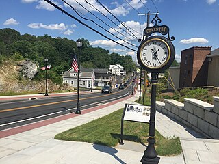
Coventry is a town in Tolland County and in the Capitol Planning Region, Connecticut, United States. The population was 12,235 at the 2020 census. The birthplace of Captain Nathan Hale, Coventry is home to the Nathan Hale Homestead, which is now a museum open to the public.

<span class="mw-page-title-main">Ellington, Connecticut</span> Town in Connecticut, United States

Ellington is a town in Tolland County, Connecticut, United States. Ellington was incorporated in May 1786, from East Windsor. The town is part of the Capitol Planning Region. As of the 2020 census, the town population was 16,426.

<span class="mw-page-title-main">Mansfield, Connecticut</span> Town in Connecticut, United States

Mansfield is a town in Tolland County, Connecticut, United States. The town is part of the Capitol Planning Region. The population was 25,892 at the 2020 census.

<span class="mw-page-title-main">Tolland, Connecticut</span> Town in Connecticut, United States

Tolland is a suburban town in Tolland County, Connecticut, United States. The town is part of the Capitol Planning Region. The population was 14,563 at the 2020 census.

<span class="mw-page-title-main">Willington, Connecticut</span> Town in Connecticut, United States

Willington is a town in Tolland County, Connecticut, United States. The town is part of the Capitol Planning Region. The population was 5,566 at the 2020 census.

<span class="mw-page-title-main">South Windham, Connecticut</span> Village in Connecticut, United States

South Windham is a village and census-designated place (CDP) in Windham County, Connecticut, United States. It is located within the town of Windham. The population was 1,421 at the 2010 census.

<span class="mw-page-title-main">Willimantic, Connecticut</span> Census-designated place in Connecticut, United States

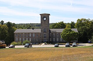
Willimantic is a census-designated place located in Windham, Connecticut, United States. Previously organized as a city and later as a borough, Willimantic is currently one of two tax districts within the Town of Windham. Willimantic is located within Windham County and the Southeastern Connecticut Planning Region. Known as "Thread City" for the American Thread Company's mills along the Willimantic River, it was a center of the textile industry in the 19th century. Originally incorporated as a city in 1893, it entered a period of decline after the Second World War, culminating in the mill's closure and the city's reabsorption into the town of Windham in the 1980s.

<span class="mw-page-title-main">Windham, Connecticut</span> Town in Connecticut, United States

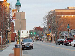
Windham is a town in Windham County, Connecticut, United States. It contains the former city of Willimantic as well as the communities of Windham Center, North Windham, and South Windham. Willimantic, an incorporated city since 1893, was consolidated with the town in 1983. The town is part of the Southeastern Connecticut Planning Region. The population was 24,428 at the 2020 census.

<span class="mw-page-title-main">Greater Hartford</span> Metropolitan Statistical Area in Connecticut, United States

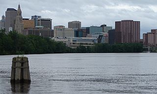
Greater Hartford is a region located in the U.S. state of Connecticut, centered on the state's capital of Hartford. It represents the only combined statistical area in Connecticut defined by a city within the state, being bordered by the Greater Boston region to the northeast and New York metropolitan area to the south and west. Sitting at the southern end of the Metacomet Ridge, its geology is characterized by land of a level grade along the shores of Connecticut River Valley, with loamy, finer-grained soil than other regions in the state. Greater Hartford, had a total population of 1,213,531 at the 2020 United States census.

<span class="mw-page-title-main">Quiet Corner</span> Rural region in Connecticut, US

Northeastern Connecticut, better known as the Quiet Corner, is a historic region of the state of Connecticut, located in the northeastern corner of the state. No official definition exists; the term is generally associated with Windham County, but also sometimes incorporates eastern sections of Tolland County and the northern portion of New London County.

<span class="mw-page-title-main">Mansfield Hollow Lake</span> Reservoir in Mansfield & Windham, Connecticut

Mansfield Hollow Lake is a reservoir resting on the border of Windham County and Tolland County, Connecticut. The reservoir provides drinking water for Willimantic and helps control flooding in the 159-square-mile Thames River watershed. It was created by the Mansfield Hollow Dam and is entirely contained within Mansfield Hollow State Park and the Mansfield Hollow Wildlife Area. Designed and constructed by the United States Army Corps of Engineers, the dam substantially reduces flooding along the Quinebaug, Shetucket, and Thames rivers. Construction of the project began in 1949 with completion in 1952 at a cost of US$6.5 million. The Mansfield Hollow reservoir is located within the Shetucket River Watershed and is part of the Thames River Basin. Access to the site is available from US Route 6 and State Route 195. The damsite, covering an area of 25 acres (10 ha), was listed on the National Register of Historic Places in 2003.

<span class="mw-page-title-main">Connecticut Route 195</span> State highway in northeastern Connecticut, US

Route 195 is a state highway in northeastern Connecticut, running from the Willimantic section of Windham to the town center of Tolland via Storrs and Mansfield Center. The road is the main thoroughfare to access the main campus of the University of Connecticut.

<span class="mw-page-title-main">Joshua's Tract Conservation and Historic Trust</span> U.S. nonprofit organization

Joshua's Tract Conservation and Historic Trust, or Joshua's Trust, is a non-profit 501(c)(3) land trust operating in northeast Connecticut. Joshua's Trust was incorporated in 1966 to help conserve property of significant natural or historic interest. As of 2011, the Trust protects more than 5,000 acres, maintains 42 miles (68 km) of trails that are open to the public, holds educational outreach programs, and publishes the Joshua's Tract Walkbook.

<span class="mw-page-title-main">Natchaug River</span> American river

The Natchaug River is a 17.9-mile-long (28.8 km) river in Windham and Tolland Counties in northeastern Connecticut. The name Natchaug comes from the Nipmuc language and is believed to mean land between rivers.

<span class="mw-page-title-main">Fenton River</span>

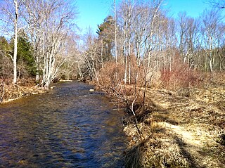
The Fenton River runs through Mansfield, Storrs, and Willington, as well as small parts of Windham, all but the latter in Tolland County, Connecticut spanning 18.895 miles. It feeds into Mansfield Hollow reservoir at its end, making it a tributary to the Mount Hope, Natchaug, and Willimantic rivers. The Fenton River is fed by several smaller brooks, streams, and creeks.

<span class="mw-page-title-main">Windham Region Transit District</span> Bus operator in Connecticut, U.S.

Windham Region Transit District, or WRTD, is a bus operator for Windham County, with NECTD, SEAT, UConn Transportation Services in neighboring towns. Prior to August 2019, The company operated four routes in total, connecting with a small handful of other operators, such as UConn Transportation Services in Mansfield, SEAT in Norwich, and NECTD in Brooklyn, Connecticut. Because of the small collection of routes, they have approximately ten fixed route buses, with some Paratransit vehicles. Beginning August 14, 2017, WRTD provided connections to CTtransit in Mansfield Storrs with the 913 Express route to Hartford, Connecticut. WRTD also provides Dial-A-Ride within their nine-town district (Ashford, Chaplin, Columbia, Coventry, Lebanon, Mansfield, Scotland, Willington and Windham. ADA Paratransit is provided for areas within 3/4 mile of WRTD's Local Routes.

Annie E. Vinton was an American postmistress, politician, and dignitary of Mansfield, Connecticut. She served in the Connecticut House of Representatives. A local elementary school and University of Connecticut dormitory are named in her honor.

References

  1. 1 2 "Quick Facts:Storrs CDP, CT". US Census Bureau Quick Facts. United States Census Bureau.
  2. Principal Communities in Connecticut, Dept. of Economic and Community Development
  3. "History – University of Connecticut". uconn.edu.
  4. Koerner, Brendan (September 15, 2005). "Where to hide from Mother Nature". Slate.com. Retrieved November 10, 2013.
  5. "U.S. Climate Normals Quick Access – Station: Storrs, CT". National Oceanic and Atmospheric Administration. Retrieved February 10, 2023.
  6. "NOAA Online Weather Data – NWS Boston". National Weather Service. Retrieved February 10, 2023.
  7. "U.S. Census website". United States Census Bureau . Retrieved January 31, 2008.
  8. "Nash-Zimmer Transportation Center". Town of Mansfield Departments and Offices. Mansfield, Connecticut.
  9. "674 A-B-C-D-E Storrs-Mansfield to Willimantic". Windham Region Transit District.
  10. "675-676 Hunting Lodge and Depot Campus". Windham Region Transit District.
  11. "Transportation Services". University of Connecticut Facilities Operations. University of Connecticut.
  12. "Express Services". CT Transit Services. CT Transit.
  13. "Travel Network Map". Peter Pan Travel Center. Peter Pan Bus Lines.
  14. Official Guide of the Railways, August 1958, New Haven section, Table 7 (p. 154), Table 31 (p. 165)
  15. Karr, Ronald Dale (2017). The Rail Lines of Southern New England (2 ed.). Branch Line Press. p. 112. ISBN   9780942147124.
  16. "Willimantic, Connecticut (WIM)". TrainWeb Station Details. TrainWeb.
  17. "Amtrak returns to Willimantic". The Hartford Courant. November 2, 1991.
  18. "Amtrak's decision to derail Montrealer a blow to Willimantic". The Hartford Courant. December 19, 1994.
  19. "Central Corridor Rail Line" (PDF). Rhode Island Association of Rail Passengers. Archived from the original (PDF) on July 27, 2011. Retrieved February 16, 2011.
  20. Spiegel, Jan Ellen (January 4, 2016). "Massive rail plan leaves Connecticut hopeful but mystified". The Connecticut Mirror.
  21. Ana, Radelat (September 7, 2016). "Feds' undisclosed 'preferred route' for rail lines sparks outrage". The Connecticut Mirror.
  22. Condon, Tom (February 2, 2021). "It has been slow to arrive, but high speed rail could be coming". The Connecticut Mirror.