Woodbury, Connecticut

Last updated

Woodbury, Connecticut
Town of Woodbury
King Solomon's Lodge No.7.jpg
King Solomon's Lodge No.7, chartered in 1765
WoodburyCTseal.JPG
Litchfield County Connecticut Incorporated and Unincorporated areas Woodbury Highlighted 2010.svg
Woodbury, Connecticut
Coordinates: 41°33′43″N73°12′34″W / 41.56194°N 73.20944°W / 41.56194; -73.20944
CountryFlag of the United States.svg  United States
U.S. state Flag of Connecticut.svg  Connecticut
County Litchfield
Region Naugatuck Valley
Named1673
Government
  Type Selectman-town meeting
  First SelectmanBarbara Perkinson (R) [1]
  SelectmanGeorge Hale (D) [2]
  SelectmanKaren Reddington-Hughes (R) [3]
Area
  Total36.6 sq mi (94.9 km2)
  Land36.4 sq mi (94.3 km2)
  Water0.2 sq mi (0.6 km2)
Elevation
243 ft (74 m)
Population
 (2020) [4]
  Total9,723
  Density267/sq mi (103.1/km2)
Time zone UTC-5 (Eastern)
  Summer (DST) UTC-4 (Eastern)
ZIP code
06798
Area code(s) 203/475
FIPS code 09-87910
GNIS feature ID0213540
Website www.woodburyct.org

Woodbury is a town in Litchfield County, Connecticut, United States. The town is part of the Naugatuck Valley Planning Region. The population was 9,723 at the 2020 census. [4] The town center, comprising the adjacent villages of Woodbury and North Woodbury, is designated by the U.S. Census Bureau as the Woodbury Center census-designated place (CDP). Woodbury was founded in 1673.

Contents

The center of Woodbury is distinctive for its mile-long stretch of older buildings lining both sides of the road. The public buildings in the National Register Historic District include the First Congregational Church (1818), the Old Town Hall (1846), the United Methodist Church, the St. Paul's Episcopal Church (1785), and the North Congregational Church (1816).

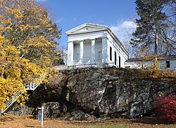
The most eye-catching of the public buildings is the Masonic Temple (1839). It is a modest, clapboard, Greek Revival temple, notable less for its architecture than for its dramatic location, situated atop a high cliff accessed by a long flight of steps (there is a modern road at the rear). It is visible from a distance and is especially dramatic at night, when it is illuminated by spotlights. The Woodbury Temple echoes the many temples of the Greek world that were perched at the edge of high places from which they could be seen from miles around and from far out at sea.

Originally, the many historic houses on the street were residential. In the late twentieth century they were occupied by a series of antique shops. Woodbury is often referred to as Connecticut's antiques capital. [5]

Woodbury is one of the two towns in Litchfield County, along with Bethlehem, served by the area code 203/area code 475 overlay.

Geography

Woodbury is in southern Litchfield County and is bordered to the south by New Haven County. It is 10 miles (16 km) west of Waterbury and 21 miles (34 km) northeast of Danbury. According to the United States Census Bureau, the town has a total area of 36.6 square miles (94.9 km2), of which 36.4 square miles (94.3 km2) are land and 0.2 square miles (0.6 km2), or 0.67%, are water. [6] The CDP covering the town center has a total area of 1.9 square miles (5.0 km2), all land. [7]

Woodbury lies in the Pomperaug River valley, a tributary of the Housatonic River. The Pomperaug River is formed in Woodbury by the confluence of the Nonnewaug River and the Weekeepeemee River.

Principal communities

Climate

Woodbury has a humid continental climate (Köppen climate classification Dfb). [8]

Climate data for Woodbury, Connecticut
MonthJanFebMarAprMayJunJulAugSepOctNovDecYear
Record high °F (°C)63
(17)
67
(19)
81
(27)
93
(34)
96
(36)
96
(36)
100
(38)
98
(37)
94
(34)
88
(31)
78
(26)
68
(20)
100
(38)
Mean daily maximum °F (°C)34
(1)
37
(3)
46
(8)
58
(14)
70
(21)
78
(26)
83
(28)
81
(27)
73
(23)
62
(17)
50
(10)
38
(3)
59
(15)
Mean daily minimum °F (°C)13
(−11)
14
(−10)
23
(−5)
33
(1)
43
(6)
53
(12)
58
(14)
56
(13)
48
(9)
36
(2)
28
(−2)
19
(−7)
35
(2)
Record low °F (°C)−22
(−30)
−18
(−28)
−11
(−24)
0
(−18)
22
(−6)
32
(0)
38
(3)
35
(2)
23
(−5)
14
(−10)
5
(−15)
−14
(−26)
−22
(−30)
Average precipitation inches (mm)4.03
(102)
3.3
(84)
4.57
(116)
4.29
(109)
4.5
(110)
4.2
(110)
4.2
(110)
4.44
(113)
4.63
(118)
4.44
(113)
4.39
(112)
4.17
(106)
51.16
(1,303)
Source: The Weather Channel [9]

History

The founders of Woodbury came from Stratford, Connecticut, in the early 1670s. Ancient Woodbury consisted of the present towns of Woodbury, Southbury, Roxbury, Bethlehem, most of Washington and parts of Middlebury and Oxford.

Two groups of settlers came from Stratford. The first, religious dissidents unhappy with the church in Stratford, was led by Woodbury's first minister, the Reverend Zachariah Walker. The second, led by Deacon Samuel Sherman, had been given approval by the general court to purchase land from local Native Americans in order to establish a new settlement. Together, fifteen families (about fifty people), arrived in ancient Woodbury, known as "Pomperaug Plantation", early in 1673.

In 1673, these original settlers drew up an agreement called the "Fundamental Articles", which proclaimed that as many settlers as could be accommodated would be welcomed to the new settlement. The Fundamental Articles stated that expenses of establishing the settlement would be shared by its inhabitants, and that no one was to be given more than twenty-five or less than ten acres of land. Other sections of the articles provided for common land and for land saved to be divided up for future inhabitants of the settlement. [10]

Signers of the Fundamental Articles:

The settlement was named Woodbury, which means "dwelling place in the woods", and was first recognized as a town in 1674. Deacon and captain John Minor was the first leader of the community during Woodbury's early years. Minor was the first town clerk and, along with Lieutenant Joseph Judson, served as the first deputy to the Connecticut General Court from the town of Woodbury. On October 9, 1751, the town of Woodbury was transferred from Fairfield County at the formation of Litchfield County.

On March 25, 1783, a meeting of ten Episcopal clergy in Woodbury elected Samuel Seabury the first American Episcopal bishop, the second presiding bishop of the Episcopal Church in the United States, and the first bishop of Connecticut.

The Woodbury Songbook

Cover of a library copy of the Woodbury Songbook (which contains a spelling error of Woodbury's name) Cover Noten Woodbury-Songbook Hanns-Eisler LWS1731.jpg
Cover of a library copy of the Woodbury Songbook (which contains a spelling error of Woodbury's name)

The German composer Hanns Eisler, who had taken asylum in the United States after fleeing from the Nazi rule in Germany, spent three and a half months (from June 15 to September 30, 1941) in Woodbury as the guest of another German refugee, Joachim Schumacher, and his wife Sylvia. Joachim taught classes in art history, musicology, philosophy, and other subjects at the Westover School in Middlebury. Sylvia taught piano at Westover School and privately in her home. [11] Joachim enticed Eisler to compose 20 songs on 16 US children's verses or nursery rhymes and four texts in the German language by Goethe, Eduard Mörike and Ignazio Silone. The songs were composed for female voices and suitable for a school chorus. [12] This was published as The Woodbury Songbook, or, in German, Das Woodbury Liederbüchlein with the lyrics in English and German, unfortunately with a wrong spelling of Woodbury (with two "r"s). The German translations are by Wieland Herzfelde. [13]

Demographics

Historical population
CensusPop.Note
1820 1,885
1850 2,150
1860 2,037−5.3%
1870 1,931−5.2%
1880 2,14911.3%
1890 1,815−15.5%
1900 1,9889.5%
1910 1,860−6.4%
1920 1,698−8.7%
1930 1,7442.7%
1940 1,99814.6%
1950 2,56428.3%
1960 3,91052.5%
1970 5,86950.1%
1980 6,94218.3%
1990 8,13117.1%
2000 9,19813.1%
2010 9,9758.4%
2020 9,723−2.5%
U.S. Decennial Census [14]

At the 2010 census there were 9,984 people, 4,219 households, and 2,772 families in the town. The population density was 252.2 inhabitants per square mile (97.4/km2). There were 3,869 housing units at an average density of 106.1 per square mile (41.0/km2). The racial makeup of the town was 97.25% White, 0.53% African American, 0.22% Native American, 1.15% Asian, 0.07% Pacific Islander, 0.22% from other races, and 0.57% from two or more races. Hispanic or Latino of any race were 1.65%. [15]

Of the 3,715 households 31.4% had children under the age of 18 living with them, 58.9% were married couples living together, 8.0% had a female householder with no husband present, and 30.7% were non-families. 25.4% of households were one person and 8.7% were one person aged 65 or older. The average household size was 2.48 and the average family size was 2.99.

The age distribution was 24.0% under the age of 18, 4.4% from 18 to 24, 29.3% from 25 to 44, 29.3% from 45 to 64, and 13.0% 65 or older. The median age was 41 years. For every 100 females, there were 95.3 males. For every 100 females age 18 and over, there were 91.8 males.

The median household income was $68,322 and the median family income was $82,641. Males had a median income of $53,246 versus $35,298 for females. The per capita income for the town was $37,903. About 2.3% of families and 4.5% of the population were below the poverty line, including 4.9% of those under age 18 and 6.3% of those age 65 or over.

CDP

At the 2000 census, there were x people, 618 households, and 336 families in the CDP. The population density was 668.8 inhabitants per square mile (258.2/km2). There were 644 housing units at an average density of 331.8 per square mile (128.1/km2). The racial makeup of the CDP was 98.07% White, 0.85% African American, 0.15% Native American, 0.39% Asian, 0.31% from other races, and 0.23% from two or more races. Hispanic or Latino of any race were 1.16% of the population.

Of the 618 households 25.1% had children under the age of 18 living with them, 41.9% were married couples living together, 9.5% had a female householder with no husband present, and 45.5% were non-families. 39.3% of households were one person and 15.7% were one person aged 65 or older. The average household size was 2.10 and the average family size was 2.82.

The age distribution was 20.6% under the age of 18, 5.2% from 18 to 24, 30.2% from 25 to 44, 28.1% from 45 to 64, and 15.9% 65 or older. The median age was 40 years. For every 100 females, there were 85.4 males. For every 100 females age 18 and over, there were 79.1 males.

The median household income was $51,136 and the median family income was $65,227. Males had a median income of $50,625 versus $40,729 for females. The per capita income for the CDP was $30,277. None of the families and 4.6% of the population were living below the poverty line, including no under eighteens and 8.9% of those over 64.

Government

Woodbury is currently located in Connecticut's 5th congressional district, and is represented by Democrat Jahana Hayes. The town is part of Connecticut's 32nd State Senate District [16] and is represented by State Sen. Eric Berthel. [17]

Politics

Woodbury is one of the most reliably Republican towns in the United States. Since its founding in 1854, every Republican presidential candidate has carried Woodbury, even in nationwide Democratic landslides such as 1912, 1936, and 1964 in which Democratic candidates won Connecticut. Only four times, in 1884, the aforementioned 1912, 1992, and 1996 has the GOP candidate for president not received an absolute majority of the vote. In the eleven elections from 1920–1960, the Republican candidates all broke 70% of the vote in Woodbury, with the party's best showing coming in 1928 when Herbert Hoover received 84.17% of the vote. The best showing for any Democrat in Woodbury since the founding of the GOP occurred in 1964 when Lyndon Johnson received 48.82% of the vote in an election where he won Connecticut with 67.81% of the vote.

Similarly, Woodbury has also supported the last 36 GOP campaigns for governor of Connecticut.

Prior to the GOP’s founding, Woodbury supported Whig presidential nominees Winfield Scott, Zachray Taylor, Henry Clay, and John Quincy Adams in 1852, 1848, 1832, and 1828 respectively. Adams of whom has the largest percentage of the vote since 1828 for a presidential candidate in Woodbury at 88.36%. In 1836, 1840, and 1844, Martin Van Buren, and James K. Polk carried Woodbury, they remain the only two Democratic presidential candidates to carry the town, as of the 2020 presidential election.

The results for Woodbury in all presidential elections since 1828, and all gubernatorial elections since 1924 can be found below:

Woodbury town vote
by party in presidential elections [18]
Year Democratic Republican Third Parties
2020 [19] 48.50% 3,18150.24%3,2951.26% 83
2016 [20] 42.05% 2,46654.07%3,1713.89% 228
2012 [21] 43.82% 2,43455.06%3,0581.12% 62
2008 [22] 48.00% 2,92651.12%3,1160.89% 54
2004 [23] 43.00% 2,51955.64%3,2601.37% 80
2000 [24] 41.93% 2,17552.09%2,7025.98% 310
1996 [25] 39.54% 1,77949.19%2,21311.27% 507
1992 [26] 31.97% 1,57444.40%2,18623.62% 1,163
1988 [27] 35.06% 1,51064.29%2,7690.65% 28
1984 [28] 27.93% 1,16471.68%2,9870.38% 16
1980 [29] 24.23% 93762.24%2,40713.52% 523
1976 [30] 32.19% 1,15867.11%2,4140.70% 25
1972 [31] 30.52% 98468.49%2,2080.99% 32
1968 [32] 30.18% 75764.83%1,6264.98% 125
1964 [33] 48.82% 1,05851.18%1,1090.00% 0
1960 [34] 24.70% 50875.30%1,5490.00% 0
1956 [35] 15.92% 28584.08%1,5050.00% 0
1952 [36] 16.22% 25883.60%1,3300.19% 3
1948 [37] 17.10% 20582.74%9921.00% 12
1944 [38] 22.28% 24077.72%8370.00% 0
1940 [39] 20.36% 20279.64%7900.00% 0
1936 [40] 26.80% 23573.20%6420.00% 0
1932 [41] 23.01% 16876.97%5620.00% 0
1928 [42] 15.41% 10884.17%5900.43% 3
1924 [43] 19.86% 11678.08%4562.05% 12
1920 [44] 23.18% 13475.61%4371.21% 7
1916 [44] 34.62% 10863.78%1991.60% 5
1912 [45] 26.42% 9846.36%17227.22% 101
1908 [45] 17.22% 7379.72%3383.06% 13
1904 [46] 22.65% 9976.43%3340.92% 4
1900 [46] 23.18% 10572.63%3294.19% 19
1896 [47] 20.57% 8772.10%3057.33% 31
1892 [47] 37.88% 16153.41%2278.71% 37
1888 [48] 39.11% 18551.80%2459.09% 43
1884 [48] 39.34% 19248.98%23911.68% 57
1880 [48] 42.38% 22857.62%3100.00% 0
1876 [48] 42.75% 22757.25%3040.00% 0
1872 [48] 38.03% 17761.97%2410.00% 0
1868 [48] 44.65% 21355.35%2640.00% 0
1864 [48] 43.75% 18956.25%2430.00% 0
1860 [48] 17.49% 6959.49%23523.04% 91
1856 [48] 41.94% 19055.85%2532.21% 10
1852 [49] 45.05% 20052.25%2322.70% 12
1848 [50] 46.33% 20851.45%2312.23% 10
1844 [51] 52.84%27047.16% 2410.00% 0
1840 [52] 55.99%22946.01% 1800.00% 0
1836 [53] 53.95%16446.05% 1400.00% 0
1832 [54] 43.54% 11856.46%1530.00% 0
1828 [55] 11.64% 2288.36%1670.00% 0
Woodbury town vote
by party in gubernatorial elections [18]
Year Democratic Republican Third Parties
2022 [56] 45.91% 2,32152.50%2,6541.59% 80
2018 [19] 39.22% 2,07357.14%3,0203.63% 192
2014 [19] 37.67% 1,59861.41%2,6050.92% 39
2010 [19] 38.61% 1,72760.32%2,6981.07% 48
2006 [19] 26.67% 1,16072.14%3,1381.20% 52
2002 [19] 29.50% 1,18770.50%2,8370.00% 0
1998 [19] 22.13% 78876.30%2,7171.57% 56
1994 [19] 25.53% 98252.89%2,03421.58% 830
1990 [19] 12.56% 44753.18%1,89234.26% 1,219
1986 [57] 46.19% 1,29753.81%1,5110.00% 0
1982 [58] 38.40% 1,22860.79%1,9440.81% 26
1978 [59] 42.79% 1,25557.21%1,6780.00% 0
1974 [60] 43.31% 1,20456.69%1,5760.00% 0
1970 [61] 25.63% 58874.37%1,7060.00% 0
1966 [62] 27.34% 50972.66%1,3530.00% 0
1962 [63] 25.45% 46774.55%1,3680.00% 0
1958 [63] 38.73% 59661.27%9430.00% 0
1954 [64] 20.88% 28878.46%1,0820.65% 9
1950 [65] 18.75% 23778.96%9982.29% 29
1948 [66] 21.58% 26077.34%9321.08% 13
1946 [67] 15.06% 13479.44%7075.51% 49
1944 [68] 16.03% 17282.95%8901.03% 11
1942 [69] 14.59% 10381.02%5724.39% 31
1940 [70] 16.55% 16679.36%7964.09% 41
1938 [71] 21.41% 17956.34%47122.25% 186
1936 [72] 28.88% 25570.55%6230.56% 5
1934 [73] 19.79% 14977.69%5850.25% 19
1932 [74] 24.31% 18671.37%5464.31% 33
1930 [75] 26.31% 14173.32%3930.37% 2
1928 [76] 15.98% 11283.59%5860.43% 3
1926 [77] 12.24% 4886.99%3410.77% 3
1924 [78] 20.42% 11879.24%4580.35% 2
1922 [79] 27.75% 14471.87%3730.39% 2
1920 [80] 23.10% 13475.52%4381.38% 8
1918 [81] 34.46% 9264.79%1730.75% 2
1916 [82] 23.10% 13475.52%4381.38% 8

Education

Woodbury is part of the Region 14 School District consisting of Nonnewaug High School, Woodbury Middle School, Bethlehem Elementary School, Mitchell Elementary School, and STAR Preschool Program. [83]

Infrastructure

Transportation

U.S. Route 6 is the main thoroughfare in the town, leading northeast 7 miles (11 km) to Watertown and south 5 miles (8 km) to Southbury. Connecticut Route 64 is a main highway leading east five miles to Middlebury and 10 miles (16 km) to Waterbury. Other highways in the town include Route 47, leading northwest to Washington; Route 61, leading north from the eastern part of town to Bethlehem; Route 132, leading north from the center of Woodbury to Bethlehem; and Route 317, leading west to Roxbury.

Notable locations

Town Hall, c. 1907 PostcardWoodburyCTTownHall1907.jpg
Town Hall, c.1907

Notable people

Local media

Related Research Articles

<span class="mw-page-title-main">Litchfield County, Connecticut</span> County in Connecticut, United States

Litchfield County is in northwestern Connecticut, United States. As of the 2020 census, the population was 185,186. The county was named after Lichfield, in England. Litchfield County has the lowest population density of any county in Connecticut and is the state's largest county by area.

<span class="mw-page-title-main">Bloomfield, Connecticut</span> Town in Connecticut, United States

Bloomfield is a suburb of Hartford in the Capitol Planning Region, Connecticut, United States. The town's population was 21,535 at the 2020 census. Bloomfield is best known as the headquarters of healthcare services company Cigna.

<span class="mw-page-title-main">Granby, Connecticut</span> Town in Connecticut, United States

Granby is a town in northern Hartford County, Connecticut, United States. The town is part of the Capitol Planning Region. The population was 10,903 at the 2020 census. The town center is defined as a census-designated place known as Salmon Brook. Other areas in town include North Granby and West Granby. Granby is a rural town, located in the foothills of the Litchfield Hills of the Berkshires, besides the suburban natured center, the outskirts of town are filled with dense woods and rolling hills and mountains. From the 1890s to the 1920s many immigrants from Sweden came to reside in the town.

<span class="mw-page-title-main">Hartland, Connecticut</span> Town in Connecticut, United States

Hartland is a town in Hartford County, Connecticut, United States. The population was 1,901 at the 2020 census. The rural town is part of the Northwest Hills Planning Region and forms the northwest border of Hartford County. Currently, the town consists of two unincorporated areas, East and West Hartland, entirely separated by the northern portion of the Barkhamsted Reservoir. A third area, Hartland Hollow, was flooded when the reservoir was completed in 1940.

<span class="mw-page-title-main">Marlborough, Connecticut</span> Town in Connecticut, United States

Marlborough is a town in Hartford County, Connecticut, United States. It contains the census-designated place (CDP) of Terramuggus. The town is part of the Capitol Planning Region. The town's population was 6,133 at the 2020 census. Marlborough is a suburban and rural community. The local high school is RHAM High School. In 2013, Marlborough ranked third in Connecticut Magazine's biannual ranking of Connecticut small towns. Educationally, RHAM High School, which serves Marlborough, Hebron, and Andover students, is one of the top-ranked regional high schools in the state on the SAT in 2017, and 11th highest-performing school in the state on the test. The town is home to Elmer Theines-Mary Hall elementary school which serves Pre-K through 6th grade. The school scores above state average on standardized testing and student progress.

<span class="mw-page-title-main">Bethlehem, Connecticut</span> Town in Connecticut, United States

Bethlehem is a town in Litchfield County, Connecticut, United States. The population was 3,385 at the 2020 census, down from 3,607 at the 2010 census. The town is part of the Naugatuck Valley Planning Region. The town center is a historic district and a census-designated place (CDP).

<span class="mw-page-title-main">Bridgewater, Connecticut</span> Town in Connecticut, United States

Bridgewater is a town in Litchfield County, Connecticut, United States. The population was 1,662 at the 2020 census, down from 1,727 at the 2010 census. The town is part of the Western Connecticut Planning Region.

<span class="mw-page-title-main">Northwest Harwinton, Connecticut</span> Census-designated place in Connecticut, United States

Northwest Harwinton is a census-designated place (CDP) in the town of Harwinton in Litchfield County, Connecticut, United States. The population was 3,158 at the 2020 census, out of 5,484 in the entire town. The CDP contains the town center.

<span class="mw-page-title-main">Oakville, Connecticut</span> Census-designated place in Connecticut, United States

Oakville is a census-designated place (CDP) and neighborhood section of Watertown, in Litchfield County, Connecticut, United States. The population was 9,047 as of the 2010 census. It is the most populous community in Watertown, with more than twice as many people as the center village of Watertown. The ZIP code for Oakville is 06779.

<span class="mw-page-title-main">Roxbury, Connecticut</span> Town in Connecticut, United States

Roxbury is a town in Litchfield County, Connecticut, United States. The population was 2,260 at the 2020 census. The town is located 65 miles (105 km) northeast of New York City, and is part of the Northwest Hills Planning Region.

<span class="mw-page-title-main">Watertown, Connecticut</span> Town in Connecticut, United States

Watertown is a town in Litchfield County, Connecticut, United States. The town is part of the Naugatuck Valley Planning Region. The population was 22,105 at the 2020 census. The ZIP Codes for Watertown are 06795 and 06779. It is a suburb of Waterbury. The urban center of the town is the Watertown census-designated place, with a population of 3,938 at the 2020 census.

<span class="mw-page-title-main">Middlebury, Connecticut</span> Town in Connecticut, United States

Middlebury is a town in New Haven County, Connecticut, United States. The population was 7,574 at the 2020 census. The town is part of the Naugatuck Valley Planning Region.

<span class="mw-page-title-main">Southbury, Connecticut</span> Town in Connecticut, United States

Southbury is a town in western New Haven County, Connecticut, United States. Southbury is north of Oxford and Newtown, and east of Brookfield. Its population was 19,879 at the 2020 census. The town is part of the Naugatuck Valley Planning Region.

<span class="mw-page-title-main">Durham, Connecticut</span> Town in Connecticut, United States

Durham is a town in Middlesex County, Connecticut, United States. Durham is a former farming village on the Coginchaug River in central Connecticut. The town is part of the Lower Connecticut River Valley Planning Region. The population was 7,152 at the 2020 census. Every autumn, the town hosts the Durham Fair, the largest volunteer agricultural fair in New England.

<span class="mw-page-title-main">Area codes 203 and 475</span> Area codes for southwestern Connecticut

Area codes 203 and 475 are telephone area codes in the North American Numbering Plan (NANP) for the southwestern part of the U.S. state of Connecticut. The numbering plan area (NPA) is mostly coextensive with the Connecticut portion of the New York metropolitan area, and comprises most of Fairfield County, all of New Haven County, and a small portion of Litchfield County.

<span class="mw-page-title-main">Connecticut's 5th congressional district</span> U.S. House district for Connecticut

Connecticut's 5th congressional district is a congressional district in the U.S. state of Connecticut. Located in the western part of the state and spanning across parts of Fairfield, Litchfield, New Haven, and Hartford Counties, the district runs from Meriden and New Britain in central Connecticut, westward to Danbury and the surrounding Housatonic Valley, encompassing the Farmington Valley, Upper Naugatuck River Valley, and the Litchfield Hills. The district also includes most of Waterbury.

<span class="mw-page-title-main">Bethlehem Village, Connecticut</span> Census-designated place in Connecticut, United States

Bethlehem Village is a census-designated place (CDP) within the town of Bethlehem in Litchfield County, Connecticut, United States. The CDP includes the Bethlehem Green Historic District at the town center, as well as surrounding residential and rural land. As of the 2010 census, the CDP had a population of 2,021, out of a population of 3,607 for the entire town of Bethlehem.

<span class="mw-page-title-main">Woodbury Center, Connecticut</span> Census-designated place in Connecticut, United States

Woodbury Center is a census-designated place (CDP) in Litchfield County, Connecticut, United States. It comprises the twin villages of Woodbury and North Woodbury and surrounding residential land in the town of Woodbury. As of the 2010 census, the population of the CDP was 1,294, out of 9,975 in the entire town.

<span class="mw-page-title-main">Central Naugatuck Valley</span> Place in Connecticut, United States

The Central Naugatuck Valley is a region of Connecticut in New Haven and Litchfield counties located approximately 70 miles (110 km) northeast of New York City and 110 miles (180 km) southwest of Boston, United States. The region comprises 13 towns: Beacon Falls, Bethlehem, Cheshire, Middlebury, Naugatuck, Oxford, Prospect, Southbury, Thomaston, Waterbury, Watertown, Wolcott, and Woodbury.

<span class="mw-page-title-main">Watertown (CDP), Connecticut</span> Census-designated place in Connecticut, United States

Watertown is a census-designated place (CDP) in Litchfield County, Connecticut, United States. It comprises the central village of the town of Watertown. As of the 2010 census, the population of the CDP was 3,574, out of 22,514 in the entire town. As of the 2020 Census, the population was 22,105.

References

  1. https://woodburyct.org/index.asp?SEC=994236CB-BFC4-4A07-9CAE-889C470AB1F0
  2. https://woodburyct.org/index.asp?SEC=994236CB-BFC4-4A07-9CAE-889C470AB1F0
  3. https://woodburyct.org/index.asp?SEC=994236CB-BFC4-4A07-9CAE-889C470AB1F0
  4. 1 2 "Census - Geography Profile: Woodbury town, Litchfield County, Connecticut". United States Census Bureau . Retrieved December 23, 2021.
  5. "The Charming Connecticut Town with over 25 Antique Stores You Need to Explore". January 18, 2018.
  6. "Geographic Identifiers: 2010 Census Summary File 1 (G001), Woodbury town, Litchfield County, Connecticut". American FactFinder. U.S. Census Bureau. Archived from the original on February 13, 2020. Retrieved October 21, 2019.
  7. "Geographic Identifiers: 2010 Census Summary File 1 (G001), Woodbury Center CDP, Connecticut". American FactFinder. U.S. Census Bureau. Archived from the original on February 13, 2020. Retrieved October 21, 2019.
  8. "Average Weather for Woodbury, CT – Temperature and Precipitation". Weather.com. Retrieved November 17, 2017.
  9. "Average Weather for Woodbury, CT – Temperature and Precipitation". Weather.com. Retrieved November 17, 2017.
  10. Cothren, William (November 30, 1854). "History of ancient Woodbury, Connecticut, from the first Indian deed in 1659 ... including the present towns of Washington, Southbury, Bethlem, Roxbury, and a part of Oxford and Middlebury". Waterbury, Conn., Bronson Brothers. Retrieved November 30, 2022 via Internet Archive.
  11. Westover School - Giving Girls a Place of Their Own, Laurie Lisle, Wesleyan University Press, Middletown, CT (2009), page 106
  12. Meyer, Günter (1996). Chorlieder, Kinderlieder, Volkslieder[Chorus songs, children songs, folk songs] (CD Booklet). Berlin Classics (in German). Berlin: edel Gesellschaft für Produktmarketing. 0092322BC, LC6203.
  13. Hanns Eisler. Eisler: Woodburry-Liederbüchlein (musical scores). Breitkopf & Härtel. p. 32. ISMN  979-0-2004-7043-7. UPC   9790200470437. ISMN = International Standard Music Number
  14. "Census of Population and Housing". Census.gov. Retrieved June 4, 2015.
  15. "U.S. Census website". United States Census Bureau . Retrieved January 31, 2008.
  16. "Connecticut General Assembly Senate Members". CGA.ct.gov. Retrieved October 24, 2022.
  17. State Sen. Eric Berthel
  18. 1 2 "General Elections Statement of Vote 1922".
  19. 1 2 3 4 5 6 7 8 9 "Dave Leip's Atlas of U.S. Presidential Elections".
  20. Statement of Vote 2016
  21. Statement of Vote 2012
  22. Statement of Vote 2008
  23. Statement of Vote 2004
  24. Statement of Vote 2000
  25. Statement of Vote 1996
  26. Statement of Vote 1992
  27. Statement of Vote 1988
  28. Statement of Vote 1984
  29. Statement of Vote 1980
  30. Statement of Vote 1976
  31. Statement of Vote 1972
  32. Statement of Vote 1968
  33. Statement of Vote 1964
  34. Statement of Vote 1960
  35. Statement of Vote 1956
  36. Statement of Vote 1952
  37. Statement of Vote 1948
  38. Statement of Vote 1944
  39. Statement of Vote 1940
  40. Statement of Vote 1936
  41. Statement of Vote 1932
  42. Statement of Vote 1928
  43. Statement of Vote 1924
  44. 1 2 "State of Connecticut register and manual". Register and Manual. 1907.
  45. 1 2 "State of Connecticut register and manual". Register and Manual. 1907.
  46. 1 2 "State of Connecticut register and manual. 1907". Register and Manual. 1907.
  47. 1 2 Register and manual of the State of Connecticut. State register and manual. Secretary of State. 1887.
  48. 1 2 3 4 5 6 7 8 9 Register and manual of the State of Connecticut. State register and manual. Secretary of State. 1887.
  49. "Connecticut election results, 1852 (President and governnor)". Hartford Courant. November 22, 1852. p. 2.
  50. Green, Samuel. "Green's Connecticut annual register and United States calendar for ...: To which is prefixed an almanac". pp. 8 v.
  51. "1844 presidential election results Connecticut". Hartford Courant. November 5, 1844. p. 2.
  52. "1840 presidential election Connecticut". Hartford Courant. November 21, 1840. p. 2.
  53. "Connecticut vote for president by town, 1836". Hartford Courant. November 12, 1836. p. 3.
  54. "Connecticut presidential election results by town, 1832". Hartford Courant. November 13, 1832. p. 2.
  55. "Connecticut towns for president, 1828". Hartford Courant. November 11, 1828. p. 2.
  56. Ctems Public [ dead link ]
  57. Statement of Vote 1986
  58. Statement of Vote 1982
  59. Statement of Vote 1978
  60. Statement of Vote 1974
  61. Statement of Vote 1970
  62. Statement of Vote 1966
  63. 1 2 Statement of Vote 1962
  64. Statement of Vote 1954
  65. Statement of Vote 1950
  66. Statement of Vote 1948
  67. Statement of Vote 1946
  68. Statement of Vote 1944
  69. Statement of Vote 1942
  70. Statement of Vote 1940
  71. Statement of Vote 1938
  72. Statement of Vote 1936
  73. Statement of Vote 1934
  74. Statement of Vote 1932
  75. Statement of Vote 1930
  76. Statement of Vote 1928
  77. Statement of Vote 1926
  78. Statement of Vote 1924
  79. "Region 14: STAR Preschool Program". www.ctreg14.org. Archived from the original on December 7, 2010.
  80. "Soldiers' Monument, Woodbury". ctmonuments.net.
  81. "Woodbury, CT Parks & Recreation: Facility Details".
  82. "Woodbury, Connecticut: North Green + Leroy Anderson Memorial Bandstand, North Woodbury".
  83. "Eleanor Anderson (MRS. Leroy Anderson) wife of American composer Leroy Anderson".
  84. William Robert Taylor, Wisconsin Historical Society

Further reading