New Preston, Connecticut

Last updated

New Preston, Connecticut
Newpreston03.jpg
Northerly view from Route 45/East Shore Road
Litchfield County Connecticut Incorporated and Unincorporated areas New Preston Highlighted 2010.svg
Location in Litchfield County, Connecticut
Coordinates: 41°40′28″N73°21′16″W / 41.67444°N 73.35444°W / 41.67444; -73.35444
State Connecticut
County Litchfield
Town Washington
Area
  Total7.8 sq mi (20.3 km2)
  Land7.3 sq mi (19.0 km2)
  Water0.5 sq mi (1.3 km2)
Elevation
606 ft (185 m)
Population
 (2010)
  Total1,182
  Density162/sq mi (62.4/km2)
ZIP Code
06777
FIPS code 09-52770
GNIS feature ID209251

New Preston is a rural village and census-designated place (CDP) in the northwest corner of the town of Washington, Litchfield County, Connecticut, United States. As of the 2010 census, the population of the New Preston CDP was 1,182, [1] out of 3,578 in the entire town of Washington.

Contents

New Preston Village Center
Newpreston06.jpg
Easterly view from New Preston Hill Road
Newpreston11.jpg
Northwesterly view from Main Street

Geography

The New Preston CDP includes the entire northwestern quadrant of the town of Washington, including the villages of New Preston and Marbledale, as well as 1,195-foot (364 m) Mount Bushnell and Meeker Swamp. [2] The CDP has a total area of 7.8 square miles (20.3 km2), of which 7.3 square miles (19.0 km2) are land and 0.50 square miles (1.3 km2), or 6.47%, are water. The dominant geographic feature of New Preston is Lake Waramaug, which is situated just north of the New Preston village center and is the headwaters of the East Aspetuck River, which runs through the village center and over New Preston Falls. The terrain is characterized by steep hills and narrow valleys, with a preponderance of talus slopes and ledge rock.

Demographics

As of the census [3] of 2000, there were 1,110 people, 439 households, and 303 families residing in the CDP. [4] The population density was 150.1 inhabitants per square mile (58.0/km2). There were 563 housing units at an average density of 76.1 per square mile (29.4/km2). The racial makeup of the CDP was 97.84% White, 0.36% African American, 0.09% Native American, 0.18% Asian, 0.27% from other races, and 1.26% from two or more races. Hispanic or Latino of any race were 1.17% of the population.

There were 439 households, out of which 30.3% had children under the age of 18 living with them, 60.6% were married couples living together, 5.9% had a female householder with no husband present, and 30.8% were non-families. 26.2% of all households were made up of individuals, and 11.6% had someone living alone who was 65 years of age or older. The average household size was 2.49 and the average family size was 3.00.

In the CDP, the population was spread out, with 23.4% under the age of 18, 5.3% from 18 to 24, 26.6% from 25 to 44, 27.7% from 45 to 64, and 17.0% who were 65 years of age or older. The median age was 42 years. For every 100 females, there were 102.2 males. For every 100 females age 18 and over, there were 95.9 males.

The median income for a household in the CDP was $55,962, and the median income for a family was $69,000. Males had a median income of $45,673 versus $28,333 for females. The per capita income for the CDP was $36,566. About 3.4% of families and 3.9% of the population were below the poverty line, including none of those under age 18 and 19.9% of those age 65 or over.

Many of New Preston's inhabitants are part-time residents who principally reside in New York City, so census data may not accurately reflect the population's actual demography. [5]

Transportation

The two main roads in New Preston are U.S. Route 202 and Connecticut Route 45. US 202 leads northeast 11 miles (18 km) to Litchfield and southwest 7 miles (11 km) to New Milford, while Route 45 leads north 5 miles (8 km) to Warren. There is no public transportation.

Historic Architecture of New Preston
Newpreston10.jpg
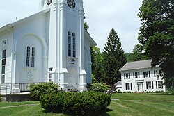
New Preston Congregational Church
Newpreston08.jpg
Former residence of Bill Blass, atop New Preston Hill
Newpreston07.jpg
A barn on New Preston Hill

History

Pre-colonial

Archeological evidence suggests that Native Americans first settled in the area around 10,000 years ago, following the retreat of the glaciers at the conclusion of the last ice age. [6] What is now known as New Preston came to be inhabited by the Wyantenock tribe of Native Americans, who spent summers at Lake Waramaug, establishing a pattern of seasonal residence that is widely repeated by New Preston's present-day occupants. [5]

Colonial

The signature of Chief Waramaug, who led the Wyantenock tribe in the early 18th century, appears on several local colonial-era property records, including the "New Milford North Purchase", which encompassed a substantial swath of southern Litchfield County, including contemporary New Preston. [7] Colonists settled New Preston in 1741, and the General Assembly of the Connecticut Colony granted a petition for the establishment of the New Preston Ecclesiastical Society in 1753. In April 1778 the 270 families living in the area petitioned the General Assembly to be incorporated as a town. The petition was granted in January of the following year, incorporating the Town of Washington from the parishes of Judea and New Preston and taking from the towns of Woodbury, Litchfield, Kent, and New Milford. [8] The action marked the first establishment of a municipality in Connecticut after the Declaration of Independence was signed. The town was named after George Washington, who, in his capacity as Commander of the Continental Army during the American Revolution, passed through the area several times. In May 1781, George Washington slept in New Preston at the Cogswell Tavern, which still stands on present-day Christian Street and is used as a private residence. [9]

19th century

In the early decades of the 19th century (the era of the Industrial Revolution), numerous mills and modestly scaled factories were constructed along the East Aspetuck River, which drops precipitously between its source at Lake Waramaug and the New Preston village center, providing a robust source of water power. New Preston housed an iron works, as well as manufacturers of twine, hats, cheese boxes, ax handles, shoes, and harnesses. [8] However, with the advent of electricity, expansion of national rail networks, and the rise of larger, more accessible manufacturing centers during the latter part of the 19th century, industrial activity in New Preston decreased, eventually disappearing altogether. [8]

In the latter decades of the 19th century, New Preston began its transformation to a summer colony. With the arrival of the Shepaug Railroad in 1872, [8] passenger service was introduced between New Preston Station and New York City, which gave rise to the construction of summer homes and inns around the perimeter of Lake Waramaug. [10]

20th century

The railroad ceased operation in 1948, and many of the large inns on the lake closed, giving way to single-family residences used primarily as vacation homes.

By the 1970s, much of New Preston's diminutive village center had fallen into decline, with many shops left vacant and in various states of disrepair. Several buildings and locations in New Preston were used in the filming of the 1981 horror movie Friday the 13th, Part 2 . [11]

In the mid-1980s, a transformation of the village center began with the opening of a store specializing in antique gardening books and horticultural prints. [5] Antique shops and other upscale retail establishments soon followed, and many of New Preston's historic commercial structures underwent renovation. The village's only grocery store, pharmacy, and gas station closed, leaving New Preston largely devoid of essential services. [12]

By the mid-1990s, the village center had been completely made over into a picturesque, high-end retail destination catering primarily to weekend residents and out-of-town visitors. [5]

Contemporary

During the booming economy of the late 1990s and early first decade of the 21st century, the gentrification of New Preston shifted into high gear. Modest lake cottages around Lake Waramaug were torn down and replaced with larger, more luxurious homes, and other lake houses underwent substantial renovation and expansion. Two of the four remaining inns on the lake—The Inn at Lake Waramaug and The Birches Inn—were converted into lavish single-family residences. [13]

Architecture

New Preston is known for its traditional rural New England architecture, which includes many well-preserved 18th and 19th century homes built in the Georgian, Greek Revival, Italianate, and Shingle styles, as well as several 19th century mill structures along the East Aspetuck River. [14] Antique barns and other agricultural outbuildings are also widely prevalent.

Because New Preston's steep, rocky terrain presents significant constraints to development, most viable development sites were utilized prior to 1900, making contemporary construction of new homes and businesses rare. As a consequence, New Preston exhibits a high degree of architectural and aesthetic cohesion. When new construction does occur, it generally follows—or attempts to follow—the historic vernacular. Portions of New Preston Hill Road and Findlay Road, three quarters of a mile west of the village center, are included in the New Preston Hill Historic District, which was listed on the National Register of Historic Places in 1985. [15] The more prominent buildings in that district include Hill Congregational Church, the Rev. Samuel Whittlesey House (1808), and the John Ferris House (1800). [16]

Open space

A substantial portion of the land in and around New Preston is permanently protected open space, which consists of state parks, local land trust holdings, and privately owned parcels under conservation easement. Public open space areas include the Macricostas Preserve, [17] Mount Bushnell State Park, and a 31-acre (130,000 m2) parcel adjacent to the New Preston village center, which the town of Washington purchased in 2010 with money from its open space fund. [18]

Scenic roads

In 1996, the Connecticut Department of Transportation designated the 6.9 miles (11.1 km) of perimeter roads around Lake Waramaug as state scenic roads, [19] affording them a legal status that discourages maintenance or improvements that would detract from the roads' scenic qualities. [20] In 2010, New Preston's main commercial thoroughfare, East Shore Road (also known as Connecticut Route 45), was designated a state scenic road, together with a 2.8-mile (4.5 km) portion of Route 202 extending northeast from the junction with Route 45 to Rabbit Hill Road.

The town of Washington has also given municipal scenic road designations in New Preston to Rabbit Hill Road, Couch Road, Gunn Hill Road, and Whittlesey Road. [21]

Postal addresses, municipalities, and nomenclature

Although the village of New Preston and the New Preston CDP are entirely within the town of Washington, U.S. Postal Service addressing practices result in the name being applied to the Marble Dale section of Washington, and to portions of the adjacent town of Warren. While New Preston village once had its own post office, it is now served by a combined New Preston-Marble Dale post office, which is located in Marble Dale, and also serves the southern portion of Warren. Further confusing matters, there are three separate post offices in the town of Washington, each with a unique ZIP code: Washington (06793), Washington Depot (06794), and New Preston-Marble Dale (06777).

Notable people

Many high-profile New York City residents and expatriates maintain homes in New Preston. Current inhabitants of note include Graydon Carter, [22] the editor of the magazine Vanity Fair , actress Christine Baranski, and bandleader Peter Duchin. [5] Past notable residents include the fashion designer Bill Blass, [23] comedian Joan Rivers, [12] and theologian Horace Bushnell. [24]

Former US Congressman Frederick Whittlesey was born here.

Related Research Articles

<span class="mw-page-title-main">Barkhamsted, Connecticut</span> Town in Connecticut, United States

Barkhamsted is a town in Litchfield County, Connecticut, United States. It contains seven villages: West Hill, Mallory, Barkhamsted Center, Center Hill, Washington Hill, Pleasant Valley, and Riverton. The population was 3,647 at the 2020 census, down from 3,799 at the 2010 census. The town is part of the Northwest Hills Planning Region. Barkhamsted was first incorporated in 1779, and named after Berkhamsted, Hertfordshire, England.

<span class="mw-page-title-main">Bethlehem, Connecticut</span> Town in Connecticut, United States

Bethlehem is a town in Litchfield County, Connecticut, United States. The population was 3,385 at the 2020 census, down from 3,607 at the 2010 census. The town is part of the Naugatuck Valley Planning Region. The town center is a historic district and a census-designated place (CDP).

<span class="mw-page-title-main">New Hartford, Connecticut</span> Town in Connecticut, United States

New Hartford is a town in Litchfield County, Connecticut, United States. The population was 6,658 at the 2020 census. The town is part of the Northwest Hills Planning Region. The town center is defined by the U.S. Census Bureau as the New Hartford Center census-designated place (CDP). The town is mainly a rural community consisting of farms, homes, and parks. Brodie Park and Ski Sundown are located in New Hartford.

<span class="mw-page-title-main">Northwest Harwinton, Connecticut</span> Census-designated place in Connecticut, United States

Northwest Harwinton is a census-designated place (CDP) in the town of Harwinton in Litchfield County, Connecticut, United States. The population was 3,158 at the 2020 census, out of 5,484 in the entire town. The CDP contains the town center.

<span class="mw-page-title-main">Oakville, Connecticut</span> Census-designated place in Connecticut, United States

Oakville is a census-designated place (CDP) and neighborhood section of Watertown, in Litchfield County, Connecticut, United States. The population was 9,047 as of the 2010 census. It is the most populous community in Watertown, with more than twice as many people as the center village of Watertown. The ZIP code for Oakville is 06779.

<span class="mw-page-title-main">Roxbury, Connecticut</span> Town in Connecticut, United States

Roxbury is a town in Litchfield County, Connecticut, United States. The population was 2,260 at the 2020 census. The town is located 65 miles (105 km) northeast of New York City, and is part of the Northwest Hills Planning Region.

<span class="mw-page-title-main">Washington, Connecticut</span> Town in Connecticut, United States

Washington is a rural town in Litchfield County, Connecticut, in the New England region of the United States. The population was 3,646 at the 2020 census. Washington is known for its picturesque countryside, historic architecture, and active civic and cultural life. The town has strong ties to New York City, and is home to many cultural and business elites. The town is part of the Northwest Hills Planning Region.

<span class="mw-page-title-main">New Milford (CDP), Connecticut</span> Census-designated place in Connecticut, United States

New Milford is a census-designated place (CDP) in Litchfield County, Connecticut, United States. It comprises the main population center within the town of New Milford. As of the 2010 census, the population of New Milford was 6,523, out of 28,142 in the entire town of New Milford.

<span class="mw-page-title-main">New Milford, Connecticut</span> Town in Connecticut, United States

New Milford is a town in Litchfield County, Connecticut, United States. The town, part of the Greater Danbury metropolitan area, lies in Western Connecticut, 14 miles (23 km) north of Danbury, on the banks of the Housatonic River, and shares its border with the northeastern shore of Candlewood Lake. It is the largest town in the state of Connecticut in terms of land area at nearly 63.7 mi² (164.9822 km2). The population as of 2020 was 28,115 according to the 2020 census. The town center is listed as a census-designated place (CDP). The northern portion of the town is part of the region of northwestern Connecticut, and the far eastern portions are part of the Litchfield Hills region.

<span class="mw-page-title-main">Lakeville, Connecticut</span> Census-designated place in Connecticut, United States

Lakeville is a census-designated place (CDP) in Litchfield County, Connecticut, United States, close to Dutchess County, New York. It is within the town of Salisbury, but has its own ZIP Code (06039). As of the 2010 census, the population of Lakeville was 928, out of 3,741 in the entire town of Salisbury. The Hotchkiss School is located in Lakeville, and the Indian Mountain School is nearby.

<span class="mw-page-title-main">Falls Village, Connecticut</span> United States historic place

Falls Village is a village and census-designated place in the town of Canaan in Litchfield County, Connecticut, United States. As of the 2010 census it had a population of 538, out of 1,234 in the entire town of Canaan. Because Falls Village is the town center and principal constituent village in Canaan, the entire town is often referred to as "Falls Village". That usage also avoids confusion of the town with Canaan Village in the town of North Canaan, Connecticut, just to the north. Falls Village derives its name from a waterfall, known as Great Falls, on the Housatonic River within the village.

<span class="mw-page-title-main">Connecticut Route 45</span> State highway in Litchfield County, Connecticut, US

Route 45 is a Connecticut state highway from US 202 in Washington to US 7 in Cornwall, in the rural northwest of the state. It is 10.29 miles (16.56 km) long and runs north–south.

<span class="mw-page-title-main">Bethlehem Village, Connecticut</span> Census-designated place in Connecticut, United States

Bethlehem Village is a census-designated place (CDP) within the town of Bethlehem in Litchfield County, Connecticut, United States. The CDP includes the Bethlehem Green Historic District at the town center, as well as surrounding residential and rural land. As of the 2010 census, the CDP had a population of 2,021, out of a population of 3,607 for the entire town of Bethlehem.

<span class="mw-page-title-main">New Hartford Center, Connecticut</span> Census-designated place in Connecticut, United States

New Hartford Center is a census-designated place (CDP) in Litchfield County, Connecticut, United States. It comprises the village of New Hartford, the adjacent Pine Meadow Historic District, and some surrounding forest land, all within the town of New Hartford. As of the 2010 census, the population of New Hartford Center was 1,385, out of 6,970 in the entire town of New Hartford.

<span class="mw-page-title-main">Woodbury Center, Connecticut</span> Census-designated place in Connecticut, United States

Woodbury Center is a census-designated place (CDP) in Litchfield County, Connecticut, United States. It comprises the twin villages of Woodbury and North Woodbury and surrounding residential land in the town of Woodbury. As of the 2010 census, the population of the CDP was 1,294, out of 9,975 in the entire town.

<span class="mw-page-title-main">Lake Waramaug</span> Natural lake in Warren & Washington, Connecticut

Lake Waramaug is a 656-acre (265 ha) lake occupying parts of the towns of Kent, Warren and Washington in Litchfield County, Connecticut, United States, approximately 24 miles (39 km) north of Danbury. The lake is named after Chief Waramaug, who wintered in the area surrounding Lake Waramaug.

<span class="mw-page-title-main">New Preston Hill Historic District</span> Historic district in Connecticut, United States

The New Preston Hill Historic District encompasses a small rural 19th-century village center in the New Preston area of the town of Washington, in Litchfield County, Connecticut. Settled in the late 18th century, it is distinctive for its examples of stone architecture, include a rare Federal period stone church. The district, located at the junction of New Preston Road with Gunn Hill and Findlay Roads, was listed on the National Register of Historic Places in 1985.

<span class="mw-page-title-main">East Aspetuck River</span> River in Connecticut, United States

The East Aspetuck River is a 9.9-mile-long (15.9 km) river in Litchfield County, Connecticut, in the United States. It flows in a southwesterly direction from its source at Lake Waramaug, in the town of Washington, through the villages of New Preston and Northville, before joining the West Aspetuck River in New Milford, a half a mile before emptying into the Housatonic River. It is a designated "wild trout management area," with special regulations in effect for its entire length.

<span class="mw-page-title-main">Canaan (village), Connecticut</span> United States historic place

Canaan is a village and census-designated place (CDP) within the town of North Canaan in Litchfield County, Connecticut, United States. Formerly known as Canaan Depot, the village is more commonly known as Canaan Village to distinguish it from the town of Canaan located to the south of North Canaan. The Canaan Village Historic District is listed on the National Register of Historic Places. As of the 2010 census, the CDP had a population of 1,212, out of a total population of 3,315 in the town of North Canaan.

<span class="mw-page-title-main">Norfolk (CDP), Connecticut</span> Census-designated place in Connecticut, United States

Norfolk is a census-designated place (CDP) in Litchfield County, Connecticut, United States. It is the central village within the town of Norfolk. As of the 2010 census, the population of the CDP was 553, out of 1,709 in the entire town.

References

  1. "Geographic Identifiers: 2010 Census Summary File 1 (G001), New Preston CDP, Connecticut". American FactFinder. U.S. Census Bureau. Archived from the original on February 13, 2020. Retrieved October 24, 2019.
  2. "TIGERweb: New Preston, Connecticut". Geography Division, U.S. Census Bureau. Retrieved October 24, 2019.
  3. "U.S. Census website". U.S. Census Bureau. Retrieved January 31, 2008.
  4. "New Preston CDP, Connecticut". U.S. Census Bureau. Archived from the original on February 12, 2020. Retrieved September 7, 2010.
  5. 1 2 3 4 5 Prevost, Lisa (July 21, 2006). "Lots of New Yorkers, but Little City Pretense". The New York Times . Retrieved March 9, 2019.
  6. "Gunn Celebrates Lake Waramaug in New Exhibit". Housatonic Times. May 16, 2010. Archived from the original on January 25, 2013.
  7. Orcutt, Samuel (March 9, 1882). The Indians of the Housatonic and Naugatuck Valleys. Press of the Case, Lockwood & Brainard Company. p.  118 . Retrieved March 10, 2019 via Internet Archive.
  8. 1 2 3 4 "About Washington, Connecticut". Town of Washington, Connecticut. Archived from the original on January 25, 2010. Retrieved September 7, 2010.
  9. "Past Exhibits: The Cogswell Family Papers". Gunn Memorial Library and Museum. Retrieved March 10, 2019.
  10. Connecticut: A Guide to Its Roads, Lore and People. US History Publishers. March 9, 1973. p. 467. ISBN   978-1-60354-007-0 . Retrieved March 10, 2019 via Google Books.
  11. "Friday The 13th Part 2: Film Location". Fridaythe13thfilms.com. Retrieved March 10, 2019.
  12. 1 2 Maker, Elizabeth (September 26, 2004). "In Warren, a Big 'For Sale' Sign". The New York Times. Retrieved March 10, 2019.
  13. Lyttle, Bethany (September 2, 2010). "House Tour: Lake Waramaug, Near New Preston, Conn". The New York Times. Retrieved March 10, 2019.
  14. "2003 Plan of Conservation and Development". The Town of Washington, Connecticut. Archived from the original on February 28, 2010. Retrieved September 7, 2010.
  15. "National Register Information System". National Register of Historic Places . National Park Service. March 13, 2009.
  16. Ransom, David F.; Herzan, John F. A. (January 29, 1985). "National Register of Historic Places Inventory-Nomination: New Preston Hill Historic District". National Park Service . and accompanying 17 photos, from 1976 and 1984
  17. "Macricostas Preserve". Steep Rock Association. Retrieved March 10, 2019.
  18. "Washington purchases 31-acre, open space parcel". Westport News . October 30, 2009. Retrieved March 10, 2019.
  19. "Criteria for Designation of Scenic Highways". Connecticut Department of Transportation. Retrieved March 10, 2019.
  20. Frisman, Paul (August 19, 2003). "Scenic Road Designations". Connecticut General Assembly. Retrieved March 10, 2019.
  21. "Scenic Roads". Town of Washington, CT. Retrieved March 10, 2019.
  22. McMullen, Troy. "A Pricey Publication". The Wall Street Journal . Archived from the original on May 16, 2008. Retrieved March 9, 2019.
  23. Michener, Charles (June 23, 2002). "Bye Bye to Bill Blass-Designer Cultivated America". The New York Observer . Archived from the original on June 29, 2008. Retrieved March 10, 2019.
  24. "A Brief History of Washington". NY-NJ-CT Botany Online. Retrieved March 10, 2019.