Bridgewater, Connecticut | |
|---|---|
Town Center Burnham Library Town Hall | |
 Seal | |
 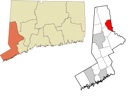 | |
 Interactive map of Bridgewater, Connecticut | |
| Coordinates: 41°31′33″N73°21′39″W / 41.52583°N 73.36083°W | |
| Country | |
| U.S. state | |
| County | Litchfield |
| Region | Western CT |
| Incorporated | 1856 |
| Government | |
| • Type | Selectman-town meeting |
| • First selectman | Curtis Read (D) |
| • Selectmen | Laszlo Pinter (R) Alan Brown (D) |
| Area | |
• Total | 17.31 sq mi (44.82 km2) |
| • Land | 16.39 sq mi (42.46 km2) |
| • Water | 0.91 sq mi (2.36 km2) |
| Elevation | 715 ft (218 m) |
| Population (2020) | |
• Total | 1,662 |
| • Density | 101.4/sq mi (39.14/km2) |
| Time zone | UTC−5 (Eastern) |
| • Summer (DST) | UTC−4 (Eastern) |
| ZIP Code | 06752 |
| Area codes | 860/959 |
| FIPS code | 09-08210 |
| GNIS feature ID | 0213397 |
| Website | bridgewater-ct.gov |


Bridgewater is a town in Litchfield County, Connecticut, United States. The population was 1,662 at the 2020 census, [1] a decline from the figure of 1,727 tabulated in 2010. The town is part of the Western Connecticut Planning Region.
Contents
- Geography
- Demographics
- Transportation
- Local media
- Education
- The Burnham Library
- Notable people
- References
- External links
Bridgewater is well known as being a weekend getaway for wealthy New Yorkers, due to its scenic wooded areas, location on the banks of Lake Lillinonah and proximity to New York City. [2] Bridgewater was one of the last remaining dry towns (Eastford is still a dry town) in Connecticut until voters approved the sale of alcohol in a 2014 referendum, by a 660–246 vote. [3] [4] The Bridgewater Country Fair is a popular annual event held every August, attracting visitors from all over New England and the Tri-state area. [5]


