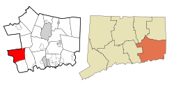
Lyme, Connecticut | |
---|---|
![]() First Congregational Church | |
![]() Location within New London County, Connecticut | |
Coordinates: 41°24′N72°21′W / 41.400°N 72.350°W Coordinates: 41°24′N72°21′W / 41.400°N 72.350°W | |
Country | ![]() |
U.S. state | ![]() |
County | New London |
Metropolitan area | New London |
Settled | 1645 |
Incorporated | February 13, 1667 |
Government | |
• Type | Selectman-town meeting |
• First selectman | Marco Supersano (R) |
Area | |
• Total | 34.5 sq mi (89.4 km2) |
• Land | 31.9 sq mi (82.5 km2) |
• Water | 2.6 sq mi (6.8 km2) |
Elevation | 26 ft (8 m) |
Population (2010) [1] | |
• Total | 2,406 |
• Density | 70/sq mi (27/km2) |
Time zone | UTC-5 (Eastern) |
• Summer (DST) | UTC-4 (Eastern) |
ZIP code | 06371 (Old Lyme) |
Area code(s) | 860/959 |
FIPS code | 09-44210 |
GNIS feature ID | 0213453 |
Website | townlyme |
Lyme is a town in New London County, Connecticut, United States, situated on the eastern side of the Connecticut River. The population was 2,406 at the 2010 census. [1] Lyme and the neighboring town of Old Lyme are the namesake for Lyme disease.
According to the United States Census Bureau, the town has a total area of 34.5 square miles (89 km2), of which 31.9 square miles (83 km2) is land and 2.6 square miles (6.7 km2), or 7.63%, is water.
Other minor communities and geographic areas are Becket Hill, Bill Hill, Brockway's Ferry (also known as Brockway Landing), Brush Hill, Elys Ferry, Grassy Hill, Gungy, Joshuatown, Lord Hill, Mt. Archer, Pleasant Valley, Rogers Lake West Shore, Sterling City, and Tuttles Sandy Beach.
Selden Neck State Park and Becket Hill State Park Reserve are wholly located in Lyme. Nehantic State Forest and Gillette Castle State Park are partly located in Lyme.
In February 1665, the portion of the territory of the Saybrook Colony east of the Connecticut River was set off as the plantation of East Saybrook, which included present-day Lyme, Old Lyme, and the western part of East Lyme. In 1667, the Connecticut General Court formally recognized the East Saybrook plantation as the town of Lyme, named after Lyme Regis, a coastal town in the south of England. The eastern portion of Lyme (bordering the town of Waterford) separated from Lyme in 1823 and became part of East Lyme. The southern portion of Lyme (along Long Island Sound) separated in 1855 as South Lyme (renamed Old Lyme in 1857). Both changes were consistent with the then-existing laws of the state of Connecticut.
Historical population | |||
---|---|---|---|
Census | Pop. | %± | |
1820 | 4,069 | — | |
1850 | 2,668 | — | |
1860 | 1,246 | −53.3% | |
1870 | 1,181 | −5.2% | |
1880 | 1,025 | −13.2% | |
1890 | 977 | −4.7% | |
1900 | 750 | −23.2% | |
1910 | 746 | −0.5% | |
1920 | 674 | −9.7% | |
1930 | 546 | −19.0% | |
1940 | 717 | 31.3% | |
1950 | 857 | 19.5% | |
1960 | 1,183 | 38.0% | |
1970 | 1,484 | 25.4% | |
1980 | 1,822 | 22.8% | |
1990 | 1,949 | 7.0% | |
2000 | 2,016 | 3.4% | |
2010 | 2,406 | 19.3% | |
2014 (est.) | 2,389 | [2] | −0.7% |
U.S. Decennial Census [3] |
As of the 2010 census, Lyme had a population of 2,406. Its racial and ethnic makeup was 96.5% non-Hispanic white, 0.1% non-Hispanic black, 0.1% non-Hispanic Native American, 1.0% Asian, 0.1% non-Hispanic from some other race, 0.6% from two or more races and 1.7% Hispanic or Latino. [4]
As of the 2000 census, [5] there were 2,016 people, 854 households, and 613 families residing in the town. The population density was 63.3 people per square mile (24.4/km2). There were 989 housing units at an average density of 31.0 per square mile (12.0/km2). Of the 854 households, 26.6% had children under the age of 18 living with them, 64.2% were married couples living together, 4.7% had a female householder with no husband present, and 28.2% were non-families. 23.2% of all households were made up of individuals, and 10.7% had someone living alone who was 65 years of age or older. The average household size was 2.35 and the average family size was 2.76. The population was spread out, with 20.3% under the age of 18, 3.1% from 18 to 24, 22.0% from 25 to 44, 34.7% from 45 to 64, and 19.9% who were 65 years of age or older. The median age was 47 years. For every 100 females, there were 99.8 males. For every 100 females age 18 and over, there were 102.5 males.
The median income for a household was $73,250, and the median income for a family was $82,853. Males had a median income of $56,188 versus $44,750 for females. The per capita income was $43,347. 1.2% of the population was living below the poverty line.
Voter registration and party enrollment as of October 27, 2020 [6] | |||||
---|---|---|---|---|---|
Party | Active voters | Inactive voters | Total voters | Percentage | |
Republican | 504 | 3 | 507 | 25.3% | |
Democratic | 740 | 5 | 745 | 37.2% | |
Unaffiliated | 709 | 11 | 720 | 35.9% | |
Minor Parties | 29 | 0 | 29 | 1.4% | |
Total | 1,982 | 19 | 2,001 | 100% |
As of 2017 the largest (those over 1% of the population) self-identified ancestry/ethnic groups in Lyme were: [7]
Largest ancestries (2017) | Percent |
---|---|
English | 30.5% |
Irish | 19.8% |
German | 14.2% |
Italian | 11.7% |
American | 7.3% |
Polish | 6.3% |
Scottish | 4.9% |
French-Canadian | 3.5% |
Swedish | 2.4% |
Norwegian | 1.6% |
Swiss | 1.5% |
Russian | 1.2% |
The Estuary Transit District provides public transportation throughout Lyme and the surrounding towns through its 9 Town Transit Service. Services include connections to Old Saybrook station, served by Amtrak and Shore Line East railroads.
Note: Some of the earlier notables on this list were residents of the part of Lyme that is now Old Lyme. [8]
New London County is in the southeastern corner of Connecticut and comprises the Norwich-New London, Connecticut Metropolitan Statistical Area, which is also included in the Hartford-East Hartford, Connecticut Combined Statistical Area. There is no county government and no county seat, as is the case with all eight of Connecticut's counties; towns are responsible for all local government activities, including fire and rescue, snow removal, and schools.
Canton is a town, incorporated in 1806, located in the Farmington Valley section of Hartford County, Connecticut, United States. The population was 8,840 at the 2000 census and 10,292 as of the 2010 census. It is bordered by Granby on the north, Simsbury on the east, Avon and Burlington on the south, New Hartford on the west, and Barkhamsted on the northwest. Running through it is the Farmington River. The town includes the villages of North Canton, Canton Center, Canton, and Collinsville. In September 2007, Collinsville was ranked in Budget Travel magazine as one of the "Ten Coolest Small Towns In America".
Chester is a town in Middlesex County, Connecticut, United States. The population was 3,994 at the 2010 census. The town center is defined by the U.S. Census Bureau as a census-designated place (CDP). The name is a transfer from Chester, in England.
Cromwell is a town in Middlesex County, Connecticut, United States located in the middle of the state. The population was 14,005 at the 2010 census.
Deep River is a town in Middlesex County, Connecticut. The population was 4,629 at the 2010 census. The town center is designated by the U.S. Census Bureau as a census-designated place (CDP). Deep River is part of what the locals call the "Tri-town Area", made up of the towns of Deep River, Chester, and Essex.
Killingworth is a town in Middlesex County, Connecticut, United States. The population was 6,455 as of July 1, 2015.
Old Saybrook is a town in Middlesex County, Connecticut, United States. The population was 10,242 at the 2010 census. It contains the incorporated borough of Fenwick, as well as the census-designated places of Old Saybrook Center and Saybrook Manor.
Westbrook is a town in Middlesex County, Connecticut, United States. The population was 6,938 at the 2010 census. The town center is classified by the U.S. Census Bureau as a census-designated place (CDP).
Lisbon is a town in New London County, Connecticut, United States, 7.3 miles (11.7 km) by road northeast of Norwich. The population was 4,338 at the 2010 census. The town center is also known as the village of Newent. The town school is Lisbon Central School. Its only postal code, 06351, is Jewett City, Connecticut, which is a village of the town of Griswold, Connecticut and encompasses all of Lisbon and Griswold.
Niantic is a census-designated place (CDP) and village in the town of East Lyme, Connecticut in the United States. The population was 3,114 at the 2010 census. It is located on Long Island Sound, the Millstone Nuclear Power Plant in nearby Waterford is visible on the bay's eastern horizon line, Rocky Neck State Park is also located in the area. Niantic was once famous for its Niantic River scallops, but the scallop population has been in decline for a number of years.
Old Lyme is a coastal town in New London County, Connecticut, United States. The town has several beach areas that offer summer rentals of cottages by the week or the month. The Main Street of the town, Lyme Street, is a historic district with several homes once owned by sea captains. The town has an art school and a thriving art community. The town is named after Lyme Regis, England.
Preston is a town in New London County, Connecticut, United States. The population was 4,726 at the 2010 census. The town includes the villages of Long Society, Preston City, and Poquetanuck.
Vernon is the most populous town in Tolland County, Connecticut, United States. The population was 29,179 at the 2010 census. Vernon contains the smaller villages of Talcottville and Dobsonville. Vernon contains the former City of Rockville.
Eastford is a town in Windham County, Connecticut, United States. The population was 1,749 at the 2010 census.
Sterling is a town in Windham County, Connecticut, United States. The population was 3,830 at the 2010 census.
Westmoreland is a town in Cheshire County, New Hampshire, United States. The population was 1,874 at the 2010 census. Westmoreland is historically an agricultural town, with much arable farmland.
Lyme is a town along the Connecticut River in Grafton County, New Hampshire, United States. The population was 1,716 as of the 2010 census, with an estimated population of 1,674 in 2017. Lyme is home to the Chaffee Natural Conservation Area. The Dartmouth Skiway is in the eastern part of town, near the village of Lyme Center. The Appalachian Trail passes through the town's heavily wooded eastern end.
Orford is a town in Grafton County, New Hampshire, United States. The population was 1,237 at the 2010 census. The Appalachian Trail crosses in the east.
Lima is a town in Livingston County, New York, United States. The population was 4,305 at the 2010 census. The town is in the northeast part of the county, south of Rochester. The village of Lima is located within the town.
Clinton is a town in Middlesex County, Connecticut, United States. The population of the town was 13,260 at the 2010 census. The town center along the shore line was listed as a census-designated place (CDP) by the U.S. Census Bureau in the 2000 census.
![]() | Wikimedia Commons has media related to Lyme, Connecticut . |