
New London County is a county in the southeastern corner of Connecticut and comprises the Norwich-New London, Connecticut Metropolitan Statistical Area, which is also included in the Hartford-East Hartford, Connecticut Combined Statistical Area. There is no county government and no county seat, as is the case with all eight of Connecticut's counties; towns are responsible for all local government activities, including fire and rescue, snow removal, and schools.

Old Lyme is a coastal town in New London County, Connecticut, United States, bounded on the west by the Connecticut River, on the south by the Long Island Sound, on the east by the town of East Lyme, and on the north by the town of Lyme. The town is part of the Lower Connecticut River Valley Planning Region.
The Mill River is a river in New Haven County, Connecticut, United States.

Connecticut's 2nd congressional district is a congressional district in the U.S. state of Connecticut. Located in the eastern part of the state, the district includes all of New London County, Tolland County, and Windham County, along with parts of Hartford, Middlesex, and New Haven counties. Principal cities include Enfield, Norwich, New London, and Groton.

Mayberry Village is an area in east central East Hartford, Connecticut, United States. The neighborhood was originally developed in the 1940s to house the influx of people who worked at Pratt and Whitney and other defense industries in Connecticut. It is roughly bounded by Burnside Avenue to the north and Wilbur Cross Highway the south. To the east is the Hockanum River, across from which is Wickham Park, mostly in Manchester.

The Chester–Hadlyme Ferry is a seasonal ferry crossing the Connecticut River between the town of Chester, Connecticut, and the village of Hadlyme. It is the second oldest continuously operating ferry service in the state of Connecticut and is a state-designated historical landmark. The ferry is part of the scenic portion of Route 148 and provides a convenient link between two of Connecticut's tourist attractions: Gillette Castle State Park in Hadlyme and the Essex Steam Train, which runs between Essex and Chester.

The source of the Eightmile River is a swampy, undeveloped region in the town of East Haddam, Connecticut, centered between Ackley Road, Hall Kilbourne Road, Usher Swamp Road, and Miles Standish Road. The Eightmile River runs for 13.4 miles (21.6 km) to Hamburg Cove in the town of Lyme, Connecticut.

The Jeremy River, named after Jeremy Adams, begins at a drainage just north of Holbrook Pond about 1.5 miles (2.4 km) east of Gilead, Connecticut, and runs for 10.7 miles (17.2 km) to the Salmon River in Colchester, Connecticut. There are many swamps and marshes along the banks of its northern end, the largest of which is 1.5 miles (2.4 km) long.

The Quinnipiac Trail is a 24-mile (39 km) Blue-Blazed hiking trail in New Haven County, Connecticut. It is the product of the evolution and growth of the first 10.6-mile (17.1 km) trail designated in Connecticut's Blue-Blazed Hiking Trail system, with its light-blue rectangular vertical painted blazes.
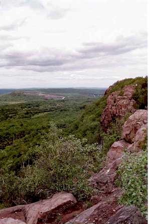
The Mattabesett Trail is a 62-mile (100 km) long, hook-shaped blue-blazed hiking trail in central Connecticut and a part of the New England National Scenic Trail. One half of the trail follows the high traprock ridges of the Metacomet Ridge, from Totoket Mountain in Guilford, Connecticut, to Lamentation Mountain in Meriden, Connecticut, from south to north. This ridge is known for its biodiversity, miles of scenic cliffs, and rugged hiking. The second half of the trail extends north from Guilford to Middletown, Connecticut, and ends at the Connecticut River. Here, the trail follows an upland of metamorphic rock with occasional views and dense forests.

The Pinchot Sycamore is a large American sycamore in Simsbury, Connecticut. It is the largest tree in Connecticut. When measured by the Connecticut Botanical Society in 2016, the Pinchot Sycamore's trunk was over 28 feet (8.5 m) around and 100 feet (30 m) tall, with an average canopy diameter of 121 feet (37 m). The sycamore is estimated to be at least 200 years old, and possibly over 300 years old. The tree was named in honor of influential conservationist and Connecticut resident Gifford Pinchot. It was originally dedicated to Pinchot in 1965, and re-dedicated with an engraved stone marker in 1975.

The Connecticut River Museum is a U.S. educational and cultural institution based at Steamboat Dock in Essex, Connecticut that focuses on the marine environment and maritime heritage of the Connecticut River Valley.

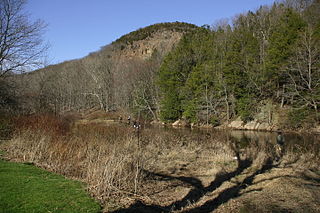
The Lieutenant River is a 3.7-mile-long (6.0 km) tidal river located in Old Lyme, Connecticut. It joins the Connecticut River in the estuary, just above the point where that river flows into Long Island Sound.

The Naugatuck Trail is a 6.8-mile (10.9 km) Blue-Blazed hiking trail "system" in the eastern central-lower Naugatuck River Valley in New Haven County, Connecticut, USA. It is almost entirely contained in the Naugatuck State Forest. The mainline trail is primarily east to west with three short side or spur trails. Composed of four trails, at its western end the trail ends with a section alongside Route 8 and the Naugatuck River. During the 1930s and 1940s, it was much larger. But post–World War II housing developments of the Connecticut Blue-Blazed Trails, led to its drastic reduction.
The Duck River Cemetery, also known as the Old Lyme Cemetery is the communal burying ground of the town of Old Lyme, Connecticut. The earliest surviving grave marker dates from 1676, Renold Marvin's gravestone. A tidal stream known as the Duck River and a salt marsh bisect the burying ground.
Pope's Flat is the second largest of the four islands owned by Stratford, Connecticut in the Housatonic River between I-95 and the Merritt Parkway. The island is north of the Moses Wheeler Bridge, northeast of Carting Island, Long Island (Connecticut) and Peacock Island (Connecticut), and south of Fowler Island in Milford and the Igor I. Sikorsky Memorial Bridge. The island is uninhabited except for occasional visits by anglers, bird watchers and duck hunters.
Long Island is the second smallest of the four islands owned by Stratford, Connecticut in the Housatonic River between I-95 and the Merritt Parkway. The island is north of the Moses Wheeler Bridge, northeast of Carting Island and Peacock Island (Connecticut), west of Pope's Flat and south of Fowler Island in Milford and the Igor I. Sikorsky Memorial Bridge. The island is uninhabited except for occasional visits by anglers, bird watchers and duck hunters.
Watch Rock Park is a 25-acre park in Old Lyme, Connecticut owned by the Old Lyme Conservation Trust. It is located off Joel Road at the point where the Duck River (Connecticut) flows into the Connecticut River, just above the point where the Connecticut flows into Long Island Sound.
The Fenton River runs through Mansfield, Storrs, and Willington, as well as small parts of Windham, all but the latter in Tolland County, Connecticut spanning 18.895 miles. It feeds into Mansfield Hollow reservoir at its end, making it a tributary to the Mount Hope, Natchaug, and Willimantic rivers. The Fenton River is fed by several smaller brooks, streams, and creeks.
Long Lane School was a prison for juvenile inmates in Middletown, Connecticut. Historically a prison for delinquent girls, it underwent various name changes, was acquired by the state in 1924, and began housing boys in 1972. Prior to its 2003 closure, it was operated by the Connecticut Department of Children and Families, and was for inmates of the ages 11–16. It was a locked and high-security facility. In its lifetime, Long Lane remained unfenced.
