Related Research Articles

Ancram is a town in Columbia County, New York, United States. The population was 1,440 at the 2020 census, down from 1,573 at the 2010 census. The town was named after Ancram, Scotland.
Canaan is a town in Columbia County, New York, United States. The population was 1,570 at the 2020 census, down from 1,710 at the 2010 census. The town is in the northeastern part of the county.

The Walloomsac River from the Native American name, Wal-loom-sac is a 16.8-mile-long (27.0 km) tributary of the Hoosic River in the northeastern United States. It rises in southwestern Vermont, in the Green Mountains east of the town of Bennington in Woodford Hollow at the confluence of Bolles Brook and City Stream where it is labeled Walloomsac Brook on maps but is locally known as "The Roaring Branch". The river then flows west toward Bennington and passes the downtown area to the north. For many years this section was intermittent due to the water having been diverted to power mills in town. This divergence gave the name Walloomsac to a portion of the river flowing through town on the present course of South Stream. The combined Walloomsac / South Stream joins the Roaring Branch northwest of town. From here the river flows westward as the Walloomsac River and joins the Hoosic River below Hoosick Falls, New York.

Deerfield River is a river that runs for 76 miles (122 km) from southern Vermont through northwestern Massachusetts to the Connecticut River. The Deerfield River was historically influential in the settlement of western Franklin County, Massachusetts, and its namesake town. It is the Connecticut River's second-longest tributary in Massachusetts, 2.1 miles (3.4 km) shorter than Metropolitan Springfield's Westfield River.

Mount Frissell, 2,454 feet (748 m), which straddles the border of southwest Massachusetts and northwest Connecticut, is part of the Taconic Range. Frissell's south slopes include the highest point in Connecticut, a popular destination for highpointers.

Mirey Brook is a 6.5-mile-long (10.5 km) stream in northern Massachusetts and southwestern New Hampshire in the United States. It is a tributary of the Ashuelot River, itself a tributary of the Connecticut River, which flows to Long Island Sound.

Tarbell Brook is a 10.1-mile-long (16.3 km) stream located in southwestern New Hampshire and northern Massachusetts in the United States. It is a tributary of the Millers River, itself a tributary of the Connecticut River, which flows to Long Island Sound.

The Millers River is a 52.1-mile-long (83.8 km) river in northern Massachusetts, originating in Ashburnham and joining the Connecticut River just downstream from Millers Falls, Massachusetts. Sections of the river are used for whitewater kayaking, and a section upriver is popular with flatwater racers, and the river is known locally as a good place for pike fishing.
The Konkapot River is a 22.1-mile-long (35.6 km) river in southwestern Massachusetts and northern Connecticut. It is a tributary of the Housatonic River, not to be confused with the smaller Konkapot Brook in Stockbridge. The river was named for Captain John Konkapot, an Indian chief.
The Burnshirt River is a 12.9-mile-long (20.8 km) stream in Worcester County, Massachusetts. It is a tributary of the Ware River, draining ultimately into the Connecticut River and thence the Long Island Sound.
The French River is a river in south-central Massachusetts and northeastern Connecticut, USA.
The Peters River is a river in the U.S. states of Massachusetts and Rhode Island. It flows 7.0 miles (11.3 km).
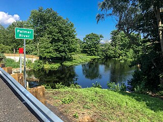
The Palmer River is a river in the U.S. states of Massachusetts and Rhode Island. It flows approximately 17 km (11 mi).

The Mill River is a river in the U.S. states of Massachusetts and Rhode Island. It flows approximately 17.1 miles (27.5 km).
The Ashaway River is a river in the U.S. states of Rhode Island and Connecticut. It flows approximately 4 km (2 mi). There are three dams along the river's length.
Abbott Run is a de facto river in the U.S. state of Massachusetts and Rhode Island. It flows approximately 10 miles (16 km).

Round Mountain, 2,296 feet (700 m), located on the border of southwest Massachusetts and northwest Connecticut, is a prominent peak of the Taconic Range. The peak and southern slopes of the mountain are within Connecticut; the northern slope lies within Massachusetts.
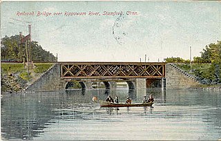
The Rippowam River is a river in Fairfield County, Connecticut and Westchester County, New York. It drains a catchment area of 37.5 square miles (97 km2) and flows for 17 miles (27 km) from Ridgefield to Long Island Sound, which it enters in Stamford's harbor.
The Salisbury Plain River is a 4.7-mile-long (7.6 km) river in Plymouth County, Massachusetts that flows from the city of Brockton into the towns of West Bridgewater and East Bridgewater where it joins the Matfield River, a major tributary of the Taunton River.
References
- ↑ U.S. Geological Survey Geographic Names Information System: Schenob Brook
- ↑ Gannett, Henry (1905). The Origin of Certain Place Names in the United States. Govt. Print. Off. pp. 176.
42°06′50″N73°21′07″W / 42.114°N 73.352°W
| | This Berkshire County, Massachusetts geography–related article is a stub. You can help Wikipedia by expanding it. |