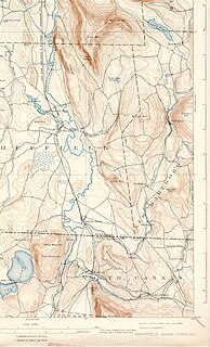
Ware is a census-designated place (CDP) comprising the main village in the town of Ware in Hampshire County, Massachusetts, United States. The population of the CDP was 6,170 at the 2010 census, out of a total town population of 9,872. It is part of the Springfield, Massachusetts Metropolitan Statistical Area.
Deerfield River is a river that runs for 76 miles (122 km) from southern Vermont through northwestern Massachusetts to the Connecticut River. The Deerfield was historically influential in the settlement of western Franklin County, Massachusetts, and its namesake town. The Deerfield River is the Connecticut River's second longest tributary in Massachusetts, 2.1 miles (3.4 km) shorter than the Metropolitan Springfield's Westfield River.

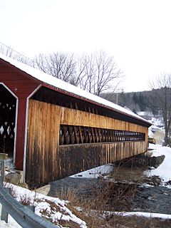
Gilbertville is an unincorporated village in the town of Hardwick, Worcester County, Massachusetts, United States, about 20 miles west of the city of Worcester. The Gilbertville Historic District and Ware–Hardwick Covered Bridge, which traverses the Ware River, are within the village.
The Jones River is a 7.5-mile-long (12.1 km) river running through Kingston, Massachusetts. The river drains about 30 square miles (78 km2), has its source in Silver Lake and drains into Kingston Bay. Land surrounding the river is 52% forested, of which 22% has been developed for residential use. There is a USGS stream gauge along 16 square miles (41 km2) of the river and it has measured the flow at 0.7 cubic feet per second (0.020 m3/s) per square mile of drainage area.

Salvaterra de Miño is a municipality (concello) in Galicia, Spain in the province of Pontevedra. The Municipality is located on the southern border of the province of Pontevedra, at the confluence of the valleys of the rivers Tea and Minho, and by the natural limits of the Serra da Cañiza. It borders the Municipalities of As Neves in the east, Mondariz and Poteareas to the north, and to the south by the Minno river. The Minno river is the southern natural border that today separates Portugal with its fortified town of Monção from current Galicia to the north.

Tarbell Brook is a 10.1-mile-long (16.3 km) stream located in southwestern New Hampshire and northern Massachusetts in the United States. It is a tributary of the Millers River, itself a tributary of the Connecticut River, which flows to Long Island Sound.

The Ware River Diversion is a dam on the Ware River. It is part of the Boston, Massachusetts public water supply system, maintained by the Massachusetts Water Resources Authority (MWRA). It is located in Worcester County in the town of Barre, close to its border with Oakham.

The North Branch of the Millers River is a river in southwestern New Hampshire and northern Massachusetts in the United States. It is a tributary of the Millers River, which flows west to the Connecticut River, which in turn flows south to Long Island Sound, an arm of the Atlantic Ocean.

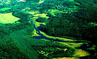
The Quaboag River is a 25.7-mile-long (41.4 km) river in Massachusetts that heads at Quaboag Pond in Brookfield at an elevation of 594 feet (181 m) above sea level. It flows west to the village of Three Rivers, Massachusetts, at an elevation of 290 feet (88 m).

Lake Lashaway is a 293-acre (1.19 km2) pond located near the East Brookfield and North Brookfield, Massachusetts town line. The town line cuts the lake approximately in half. The lake lies just to the north of state Route 9 as it passes through East Brookfield.
The East Brookfield River is a 2.4-mile-long (3.9 km) river in Massachusetts that heads at Lake Lashaway in East Brookfield at an elevation of 614 feet (187 m) above sea level. It continues to Quaboag Pond, at an elevation of 594 feet (181 m).

The Five Mile River is a 10.1-mile-long (16.3 km) river in central Massachusetts, part of the Chicopee River watershed. It rises north of Dean Pond in the Town of Oakham within Rutland State Forest and flows south through Dean Pond to Brooks Pond, 2.5 miles (4.0 km) northeast of North Brookfield, then continues south to its mouth at the north end of Lake Lashaway, also in North Brookfield.

The Millers River is a 52.1-mile-long (83.8 km) river in northern Massachusetts, originating in Ashburnham and joining the Connecticut River just downstream from Millers Falls, Massachusetts. The river was formerly known as Paquag or Baquag, a Nipmuc word meaning "clear water". Sections of the river are used for whitewater kayaking, and a section upriver is popular with flatwater racers.
The Konkapot River is a 22.1-mile-long (35.6 km) river in southwestern Massachusetts and northern Connecticut. It is a tributary of the Housatonic River, not to be confused with the smaller Konkapot Brook in Stockbridge.

Itna is an Upazila of Kishoreganj District in the Division of Dhaka, Bangladesh.

Podbielsko is a village in the administrative district of Gmina Orchowo, within Słupca County, Greater Poland Voivodeship, in west-central Poland. It lies approximately 5 kilometres (3 mi) east of Orchowo, 30 km (19 mi) north-east of Słupca, and 81 km (50 mi) east of the regional capital Poznań.
Pieńki is a settlement in the administrative district of Gmina Olecko, within Olecko County, Warmian-Masurian Voivodeship, in northern Poland. It lies approximately 6 kilometres (4 mi) north of Olecko and 138 km (86 mi) east of the regional capital Olsztyn.
Żarczyn is a village in the administrative district of Gmina Widuchowa, within Gryfino County, West Pomeranian Voivodeship, in north-western Poland, close to the German border. It lies approximately 11 kilometres (7 mi) south-east of Widuchowa, 19 km (12 mi) south of Gryfino, and 38 km (24 mi) south of the regional capital Szczecin.
The Fall River is a 14.1-mile-long (22.7 km) river in southern Vermont and northern Massachusetts, joining the Connecticut River just downstream from Turners Falls, Massachusetts.

The Third Republic of Venezuela is the name commonly used to refer to the reestablished Republic of Venezuela declared by Simón Bolívar in the year 1817, during the Venezuelan War of Independence. The beginning of the Third Republic of Venezuela is attributed to the period after the Guyana Campaign, during which the republicans restored democratic institutions in Angostura. The Republic ended after the Congress of Angostura of 1819 decreed the union of Venezuela with New Granada, to form the republic of Gran Colombia.