Connecticut Lakes

Last updated
View across a section of First Connecticut Lake First Connecticut Lake in August 2019.jpg
View across a section of First Connecticut Lake

The Connecticut Lakes are a group of lakes in Coos County, northern New Hampshire, United States, situated along the headwaters of the Connecticut River. They are accessed via the northernmost segment of U.S. Route 3, between the village of Pittsburg and the Canada port of entry south of Chartierville, Quebec. The lakes are located within the boundaries of Pittsburg, but are far from the town center. Connecticut Lakes State Forest adjoins them.

Contents

There are four lakes: First, Second, Third and Fourth Connecticut Lake, numerically running south to north. The lakes decrease in size and increase in elevation, sequentially from first to fourth. The fourth lake is the source of the Connecticut River. The first three lakes can be viewed and accessed from U.S. Route 3, while the only access to the fourth lake is via the Fourth Connecticut Lake Trail, which goes in and out of Canada. All lakes are north of the 45th parallel.

Lake Francis lies to the south of the four Connecticut Lakes. It is a man-made reservoir and the last of the major lakes along the Connecticut River in northern New Hampshire.

The lakes

First Connecticut Lake

First Connecticut Lake
USA New Hampshire relief location map.svg
Red pog.svg
First Connecticut Lake
Location Coos County, New Hampshire
Coordinates 45°5′37″N71°14′52″W / 45.09361°N 71.24778°W / 45.09361; -71.24778
Primary inflows Connecticut River
Primary outflows Connecticut River
Basin  countriesUnited States
Max. length5.3 mi (8.5 km)
Max. width2.7 mi (4.3 km)
Surface area3,071 acres (1,243 ha)
Average depth56 ft (17 m)
Max. depth163 ft (50 m)
Surface elevation1,638 ft (499 m)
Settlements Pittsburg

First Connecticut Lake is located in the town of Pittsburg, 7 miles (11 km) northeast of the village center. [1] At 3,071 acres (1,243 ha), [2] it is the eighth-largest lake located entirely in New Hampshire. It is the lowest in elevation and largest in surface area of the four Connecticut Lakes.

Fish species include landlocked salmon and lake trout. [3] The lake has average and maximum depths of 56 feet (17 m) and 163 feet (50 m), respectively. There are three public boat launch locations, [1] and ice fishing is permitted from January through March. [1] Outflow of the lake into the Connecticut River is controlled via the First Lake Dam, [1] located near U.S. Route 3 at the southwestern shore.

Climate

According to the Köppen Climate Classification system, First Connecticut Lake has a warm-summer humid continental climate, abbreviated "Dfb" on climate maps. The hottest temperature recorded at First Connecticut Lake was 93 °F (33.9 °C) on July 8, 1921 and July 19, 1953, while the coldest temperature recorded was −45 °F (−42.8 °C) on February 1, 1920. [4]

Climate data for First Connecticut Lake, New Hampshire, 1991–2020 normals, extremes 1918–present
MonthJanFebMarAprMayJunJulAugSepOctNovDecYear
Record high °F (°C)60
(16)
64
(18)
77
(25)
83
(28)
91
(33)
91
(33)
93
(34)
92
(33)
89
(32)
83
(28)
72
(22)
63
(17)
93
(34)
Mean maximum °F (°C)45.3
(7.4)
47.5
(8.6)
55.0
(12.8)
70.5
(21.4)
79.9
(26.6)
84.5
(29.2)
85.1
(29.5)
83.6
(28.7)
80.6
(27.0)
71.6
(22.0)
61.1
(16.2)
49.4
(9.7)
87.0
(30.6)
Average high °F (°C)22.4
(−5.3)
25.2
(−3.8)
34.2
(1.2)
47.1
(8.4)
61.5
(16.4)
70.4
(21.3)
75.0
(23.9)
73.6
(23.1)
66.4
(19.1)
52.8
(11.6)
39.9
(4.4)
28.7
(−1.8)
49.8
(9.9)
Daily mean °F (°C)11.1
(−11.6)
12.8
(−10.7)
21.9
(−5.6)
36.3
(2.4)
49.9
(9.9)
59.3
(15.2)
64.2
(17.9)
62.7
(17.1)
55.1
(12.8)
43.5
(6.4)
31.8
(−0.1)
19.9
(−6.7)
39.0
(3.9)
Average low °F (°C)−0.3
(−17.9)
0.4
(−17.6)
9.6
(−12.4)
25.5
(−3.6)
38.3
(3.5)
48.3
(9.1)
53.4
(11.9)
51.7
(10.9)
43.9
(6.6)
34.1
(1.2)
23.7
(−4.6)
11.1
(−11.6)
28.3
(−2.0)
Mean minimum °F (°C)−27.0
(−32.8)
−24.6
(−31.4)
−18.5
(−28.1)
6.6
(−14.1)
25.1
(−3.8)
32.6
(0.3)
40.7
(4.8)
38.4
(3.6)
28.7
(−1.8)
19.6
(−6.9)
4.6
(−15.2)
−14.0
(−25.6)
−30.0
(−34.4)
Record low °F (°C)−44
(−42)
−45
(−43)
−36
(−38)
−17
(−27)
14
(−10)
25
(−4)
29
(−2)
28
(−2)
18
(−8)
8
(−13)
−13
(−25)
−44
(−42)
−45
(−43)
Average precipitation inches (mm)3.02
(77)
2.37
(60)
3.04
(77)
3.60
(91)
4.47
(114)
5.14
(131)
4.91
(125)
4.76
(121)
4.00
(102)
4.63
(118)
3.62
(92)
3.57
(91)
47.13
(1,199)
Average snowfall inches (cm)30.3
(77)
28.4
(72)
24.6
(62)
9.7
(25)
1.0
(2.5)
0.0
(0.0)
0.0
(0.0)
0.0
(0.0)
0.0
(0.0)
2.5
(6.4)
14.6
(37)
31.9
(81)
143.0
(363)
Average extreme snow depth inches (cm)22.3
(57)
27.9
(71)
29.4
(75)
16.9
(43)
0.9
(2.3)
0.0
(0.0)
0.0
(0.0)
0.0
(0.0)
0.0
(0.0)
1.2
(3.0)
6.9
(18)
14.9
(38)
30.6
(78)
Average precipitation days (≥ 0.01 in)18.314.615.215.014.615.214.814.112.115.516.719.3185.4
Average snowy days (≥ 0.1 in)16.813.511.55.30.70.00.00.00.01.78.615.573.6
Source 1: NOAA [5]
Source 2: National Weather Service [4]

A marker along the southwestern shore of the lake commemorates Luther Parker, a historical figure of the Republic of Indian Stream in the 1830s.

FirstConnLake.jpg
Topographic map of First Connecticut Lake
Luther Parker marker at First Connecticut Lake 2.jpg
Marker for Luther Parker at First Connecticut Lake

Second Connecticut Lake

Second Connecticut Lake
USA New Hampshire relief location map.svg
Red pog.svg
Second Connecticut Lake
Location Coos County, New Hampshire
Coordinates 45°9′23″N71°10′14″W / 45.15639°N 71.17056°W / 45.15639; -71.17056
Primary inflows Connecticut River
Primary outflows Connecticut River
Basin  countriesUnited States
Max. length3.1 mi (5.0 km)
Max. width1.3 mi (2.1 km)
Surface area1,102 acres (4 km2)
Average depth20 ft (6.1 m)
Max. depth63 ft (19 m)
Surface elevation1,866 ft (569 m)
Islands 3
Settlements Pittsburg

Second Connecticut Lake, known in the past as Lake Carmel, [6] is a 1,102-acre (446 ha) [2] water body in the town of Pittsburg, 15 miles (24 km) northeast of the village center. [7] The second lake is 228 feet (69 m) higher in elevation than the first lake, and shallower.

Fish species include brook trout, landlocked salmon, and lake trout. [8] There is one public boat launch location, [7] and ice fishing is permitted from January through March. [7] Outflow of the lake into the Connecticut River is controlled via the Second Lake Dam, [7] located near U.S. Route 3 at the southwestern shore.

SecondConnLake.jpg
Topographic map of Second Connecticut Lake
Second Connecticut Lake in August 2019.jpg
Second Connecticut Lake near the Second Lake Dam

Third Connecticut Lake

Third Connecticut Lake
USA New Hampshire relief location map.svg
Red pog.svg
Third Connecticut Lake
Location Coos County, New Hampshire
Coordinates 45°14′15″N71°12′0″W / 45.23750°N 71.20000°W / 45.23750; -71.20000
Primary inflows Connecticut River
Primary outflows Connecticut River
Basin  countriesUnited States
Max. length1.1 mi (1.8 km)
Max. width0.5 mi (0.80 km)
Surface area231 acres (93 ha)
Average depth42 ft (13 m)
Max. depth101 ft (31 m)
Surface elevation2,188 ft (667 m)
Settlements Pittsburg

Third Connecticut Lake, at one time known as Lake St. Sophia, [6] is a 231-acre (93 ha) [2] water body in the town of Pittsburg, situated 20 miles (32 km) northeast of the village center, [9] and less than 1 mile (1.6 km) south of the Canadian border. It reaches a maximum depth of approximately 100 feet (30 m), [10] and sits 322 feet (98 m) higher in elevation than the second lake.

Fish species include rainbow trout and lake trout. [10] There is one public boat launch location, [9] off of U.S. Route 3 along the eastern shore of the lake. Ice fishing is permitted from January through March. [9]

ThirdFourthConnLake.jpg
Topographic map of the Third and Fourth Connecticut Lakes
Third Connecticut Lake in August 2019.jpg
Third Connecticut Lake near the public boat launch along U.S. Route 3

Fourth Connecticut Lake

Fourth Connecticut Lake
USA New Hampshire relief location map.svg
Red pog.svg
Fourth Connecticut Lake
Location Coos County, New Hampshire
Coordinates 45°14′52″N71°12′52″W / 45.24778°N 71.21444°W / 45.24778; -71.21444
Primary outflows Connecticut River
Basin  countriesUnited States
Max. length0.1 miles (.16 km)
Surface area1.8 acres (0.73 ha)
Surface elevation2,670 ft (810 m)
Settlements Pittsburg

Fourth Connecticut Lake is the northernmost and most remote of the Connecticut Lakes; it is also the smallest, at 1.8 acres (0.73 ha). It is the source of the Connecticut River, and is situated in the town of Pittsburg, 0.5 miles (0.80 km) upstream from and 482 feet (147 m) higher than Third Connecticut Lake. The fourth lake is immediately to the northwest of the third lake. The Fourth Connecticut Lake Trail leads hikers to the lake.

Fourth Connecticut Lake Trail

The Fourth Connecticut Lake Trail is a public trail maintained by The Nature Conservancy that criss-crosses the international border between New Hampshire and Quebec for 0.6 miles (0.97 km) ending with a 0.5-mile (0.80 km) loop around the Fourth Connecticut Lake. [11] It is one of the few international trails in North America. The land surrounding the lake is owned by The Nature Conservancy.

Trail sign Fourth Connecticut Lake Trail sign.jpg
Trail sign

The parking area for hikers is at the American facility of the Pittsburg–Chartierville Border Crossing, located 22 miles (35 km) north of the Pittsburg town center via U.S. Route 3. [12] [13] [14] The trail begins about 50 yards (46 m) to the right of the American building, with a small kiosk at the trailhead. [12]

The trail has no cell phone coverage, requires some non-technical climbing, and starts at a good elevation—hikers should be prepared, even in summer. Pets are not allowed on the trail, and no camping, hunting, or fishing is allowed. [11]

For persons starting in the United States, passports are not needed to hike the trail as, even though parts of the trail are in Canada, the trail starts and ends on the American side of the international border. For persons starting in Canada, a passport or other border crossing document would be required in order to enter the United States at the border facility before hiking the trail.

Connecticut Lakes Natural Area

USGS map of First, Second, and Third Connecticut Lakes (bottom to top) ConnLakes.jpg
USGS map of First, Second, and Third Connecticut Lakes (bottom to top)

The 25,000 acres (10,000 ha) surrounding the lakes was set aside as a land conservation project in 2002 by the New Hampshire Fish and Game Department. The protected area is within the towns of Clarksville and Pittsburg, up to the border with Canada. [15]

See also

Related Research Articles

<span class="mw-page-title-main">Appalachian Trail</span> Hiking trail going through fourteen US states

The Appalachian Trail, also called the A.T., is a hiking trail in the Eastern United States, extending almost 2,200 miles (3,540 km) between Springer Mountain in Georgia and Mount Katahdin in Maine, and passing through 14 states. The Appalachian Trail Conservancy claims the Appalachian Trail to be the longest hiking-only trail in the world. More than three million people hike segments of the trail each year.

<span class="mw-page-title-main">Pittsburg, New Hampshire</span> Town in New Hampshire, United States

Pittsburg is a town in Coös County, New Hampshire, United States. The population was 800 at the 2020 census. It is the northernmost town in New Hampshire and the largest town by area in New England. U.S. Route 3 is the only major highway in the town, although the northern terminus of New Hampshire Route 145 also lies within Pittsburg.

<span class="mw-page-title-main">Mount Monadnock</span> Mountain in New Hampshire, USA

Mount Monadnock, or Grand Monadnock, is a mountain in the towns of Jaffrey and Dublin, New Hampshire. It is the most prominent mountain peak in southern New Hampshire and is the highest point in Cheshire County. It lies 38 miles (61 km) southwest of Concord and 62 miles (100 km) northwest of Boston. At 3,165 feet (965 m), Mount Monadnock is nearly 1,000 feet (305 m) higher than any other mountain peak within 30 miles (48 km) and rises 2,000 feet (610 m) above the surrounding landscape. Monadnock's bare, isolated, and rocky summit provides expansive views. It is known for being featured in the writings of Ralph Waldo Emerson and Henry David Thoreau.

<span class="mw-page-title-main">Continental Divide Trail</span> Long-distance scenic trail in the western United States

The Continental Divide National Scenic Trail is a United States National Scenic Trail with a length measured by the Continental Divide Trail Coalition of 3,028 miles (4,873 km) between the U.S. border with Chihuahua, Mexico and the border with Alberta, Canada. Frequent route changes and a large number of alternate routes result in an actual hiking distance of 2,700 miles (4,300 km) to 3,150 miles (5,070 km). The CDT follows the Continental Divide of the Americas along the Rocky Mountains and traverses five U.S. states — Montana, Idaho, Wyoming, Colorado, and New Mexico. In Montana near the Canadian border the trail crosses Triple Divide Pass.

<span class="mw-page-title-main">Connecticut River</span> River in the New England region of the United States

The Connecticut River is the longest river in the New England region of the United States, flowing roughly southward for 406 miles (653 km) through four states. It rises 300 yards south of the U.S. border with Quebec, Canada, and discharges at Long Island Sound. Its watershed encompasses 11,260 square miles (29,200 km2), covering parts of five U.S. states and one Canadian province, via 148 tributaries, 38 of which are major rivers. It produces 70% of Long Island Sound's fresh water, discharging at 18,400 cubic feet (520 m3) per second.

<span class="mw-page-title-main">U.S. Route 3</span> Highway in the United States

U.S. Route 3 (US 3) is a United States Numbered Highway running 277.90 miles (447.24 km) from Cambridge, Massachusetts, through New Hampshire, to the Canada–United States border near Third Connecticut Lake, where it connects to Quebec Route 257.

<span class="mw-page-title-main">Newfound Lake</span>

Newfound Lake is located in Grafton County, New Hampshire, United States. It is situated in the Lakes Region of central New Hampshire, in the towns of Alexandria, Bridgewater, Bristol, and Hebron. Its area of 4,451 acres (18.0 km2) places it behind only Lake Winnipesaukee and Squam Lake among lakes located entirely within New Hampshire, and fourth in the state overall, when Umbagog Lake on the Maine border is included.

<span class="mw-page-title-main">Lake Winnisquam</span> Lake in Belknap County, New Hampshire

Lake Winnisquam is in Belknap County in the Lakes Region of central New Hampshire, United States, in the communities of Meredith, Laconia, Sanbornton, Belmont, and Tilton. At 4,214 acres (1,705 ha), it is the fourth-largest lake entirely in New Hampshire. The lake is roughly triangular in shape, with the vertexes pointing north, east, and south. The lake lies along the path of the Winnipesaukee River, which enters the lake from its eastern corner and carries water from Lake Winnipesaukee via Paugus Bay and Opechee Bay. The river also flows south out of Winnisquam's southern corner, eventually joining the Merrimack River. The lake extends several miles north from the course of the Winnipesaukee River, which forms the lake's southeastern side, with the northern point being formed by the confluence of several smaller creeks near the village of Meredith Center. The lake has a maximum depth of 155 feet (47 m).

<span class="mw-page-title-main">Lake Francis (Murphy Dam)</span> Reservoir in Coos County, New Hampshire

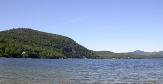
Lake Francis is a reservoir on the Connecticut River in northern New Hampshire, United States. The lake is located in Coos County, east of the village of Pittsburg and along the boundary between the towns of Pittsburg and Clarksville. The lake is impounded by Murphy Dam, built in 1940 as a flood control project. The 117-foot (36 m) earthen dam is owned by the Water Division of the state's Department of Environmental Services, and is operated by TC Energy.

<span class="mw-page-title-main">Back Lake (New Hampshire)</span> Lake in Coos County, New Hampshire

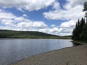
Back Lake is a 348-acre (141 ha) water body located in Coos County in northern New Hampshire, United States, in the town of Pittsburg. It is part of the Connecticut River watershed. It is situated north of Lake Francis and west of First Connecticut Lake. U.S. Route 3 passes by Back Lake's eastern shore.

<span class="mw-page-title-main">Silver Lake (Harrisville, New Hampshire)</span>

Silver Lake is a 346-acre (1.40 km2) water body located in Cheshire County in southwestern New Hampshire, United States, in the towns of Harrisville and Nelson. Water from Silver Lake flows via Minnewawa Brook and The Branch to the Ashuelot River, a tributary of the Connecticut River.

<span class="mw-page-title-main">Mount Sunapee</span>

Mount Sunapee is a 5-mile-long (8.0 km) mountain ridge in the towns of Newbury and Goshen in western New Hampshire, United States. Its highest peak, at the north end of the mountain, is 2,726 feet (831 m) above sea level. The mountain has three secondary peaks, White Ledges at 2,716 ft (828 m); North Peak at 2,280 ft (695 m); and South Peak at 2,608 ft (795 m). The north end of the mountain, including the summit, is within Mount Sunapee State Park, which encompasses 3.85 square miles (10.0 km2) and is home to the popular Mount Sunapee Resort. The mountain extends south to Pillsbury State Park in the towns of Goshen and Washington.

The Appalachian National Scenic Trail spans 14 U.S. states over its roughly 2,200 miles (3,500 km): Georgia, North Carolina, Tennessee, Virginia, West Virginia, Maryland, Pennsylvania, New Jersey, New York, Connecticut, Massachusetts, Vermont, New Hampshire, and Maine. The southern end is at Springer Mountain, Georgia, and it follows the ridgeline of the Appalachian Mountains, crossing many of its highest peaks and running almost continuously through wilderness before reaching the northern end at Mount Katahdin, Maine.

<span class="mw-page-title-main">Monadnock-Sunapee Greenway</span>

The Monadnock-Sunapee Greenway (MSG) is a 50-mile (80 km) hiking trail that traverses the highlands of southern New Hampshire from Mount Monadnock in Jaffrey to Mount Sunapee in Newbury. Located approximately 27 miles (43 km) from the city of Concord, New Hampshire, the trail traverses a rural, heavily glaciated and metamorphic upland studded with lakes, heath barrens, the rocky summits of several monadnocks, and dense woodland of the northern hardwood forest type. The trail is maintained primarily through the efforts of the Monadnock-Sunapee Greenway Trail Club.

<span class="mw-page-title-main">Hopkins Pond (New Hampshire)</span>

Hopkins Pond is a small pond located at the south foot of Ragged Mountain, in the town of Andover, New Hampshire, United States. It lies at an elevation of 644 feet (196 m). The pond is part of Proctor Academy's 2,500-acre (10 km2) campus in Andover and is jointly managed by Proctor and the New Hampshire Fish and Game Department. The pond area is open to the public for non-motorized boat travel, fishing and hiking.

<span class="mw-page-title-main">Lake Solitude (New Hampshire)</span>

Lake Solitude is a highland tarn located in western New Hampshire, United States, at the top of Sunapee Ridge between the main summit of Mount Sunapee and South Peak. The lake, covering 6 acres (2.4 ha), is approximately 832 feet (254 m) long by 383 feet (117 m) wide and is located within Mount Sunapee State Park in the town of Newbury. A popular hiking destination, Lake Solitude is accessible via the Andrew Brook Trail, the Newbury Trail, or the long-distance Monadnock-Sunapee Greenway Trail. White Ledge, elevation 2,720 feet (830 m), rises steeply above the lake's west shore and provides expansive views. The lake is considered an important habitat for rare species and is off limits to swimmers and dogs.

<span class="mw-page-title-main">Chocorua Lake</span>

Chocorua Lake is a picturesque lake in northeast New Hampshire with commanding views of the summit of Mount Chocorua. It is approximately 1.1 miles (1.8 km) long (north-south) with a maximum width of 3,500 feet (1.1 km) (east-west), covering 222 acres (90 ha), and a maximum depth of 27 feet (8.2 m).

<span class="mw-page-title-main">Willard Pond</span>

Willard Pond is a small, protected lake in Antrim, New Hampshire, United States. The lake, located in southwestern New Hampshire, is about 108 acres (44 ha) in size with an average depth of 25 feet (7.6 m) and a maximum depth of 58 feet (18 m). No petroleum motors are allowed, and fly fishing is the only form of fishing allowed. It is part of the dePierrefeu Wildlife Sanctuary, which is owned by the New Hampshire Audubon Society. Because the pond and the land around it are part of the sanctuary, the shore is unable to be developed. Therefore, there are no buildings around the pond and there won't be in the foreseeable future. Willard is instead surrounded by extensive amounts of wilderness and hiking trails that lead around the pond and to the summits of Bald Mountain and Goodhue Hill. Willard is a popular fishing, boating and hiking destination, and it has become more popular with its mention in numerous magazines and newspapers.

<span class="mw-page-title-main">Pittsburg–Chartierville Border Crossing</span>

The Pittsburg–Chartierville Border Crossing connects the towns of Chartierville, Quebec, and Pittsburg, New Hampshire. The crossing can be reached by U.S. Route 3 on the American side and by Quebec Route 257 on the Canadian side.

<span class="mw-page-title-main">Lake Armington</span> Lake in Grafton County, New Hampshire

Lake Armington is a 152-acre (0.62 km2) water body in the town of Piermont, in Grafton County on the western edge of the White Mountains in New Hampshire, United States. Water from Lake Armington flows north 0.2 miles (0.32 km) into Lake Tarleton, then west via Eastman Brook to the Connecticut River.

References

  1. 1 2 3 4 "First Connecticut Lake". New Hampshire's Connecticut Lakes Region. Retrieved August 13, 2019.
  2. 1 2 3 "Welcome To UNH/GRDC Composite Runoff Fields V1.0". www.compositerunoff.sr.unh.edu. Archived from the original on August 3, 2013.
  3. "First Connecticut Lake, Pittsburg" (PDF). NH Fish & Game. Retrieved August 12, 2014.
  4. 1 2 "NOAA Online Weather Data – NWS Gray/Portland". National Weather Service. Retrieved February 1, 2023.
  5. "U.S. Climate Normals Quick Access – Station: First Connecticut Lake, NH". National Oceanic and Atmospheric Administration. Retrieved February 1, 2023.
  6. 1 2 George Merrill Drew. "History of Coos County, New Hampshire" . Retrieved April 3, 2017.
  7. 1 2 3 4 "Second Connecticut Lake". New Hampshire's Connecticut Lakes Region. Retrieved August 13, 2019.
  8. "Second Connecticut Lake, Pittsburg" (PDF). NH Fish & Game. Retrieved August 12, 2014.
  9. 1 2 3 "Third Connecticut Lake". New Hampshire's Connecticut Lakes Region. Retrieved August 13, 2019.
  10. 1 2 "Third Connecticut Lake, Pittsburg" (PDF). NH Fish & Game. Retrieved August 12, 2014.
  11. 1 2 "Fourth Connecticut Lake Preserve" (PDF). The Nature Conservancy. Retrieved August 15, 2019.
  12. 1 2 "Fourth Connecticut Lake". The Nature Conservancy . Retrieved August 15, 2019.
  13. Pletcher, Larry (May 2019). Hiking New Hampshire: A Guide to New Hampshire's Greatest Hiking Adventures. Rowman & Littlefield. ISBN   978-1-4930-3459-8.
  14. Delorey, Alan (1996). A Birder's Guide to New Hampshire. American Birding Association. ISBN   978-1-878788-11-5.
  15. New Hampshire Wildlife Management Areas Archived 2012-01-25 at the Wayback Machine . Wildlife.state.nh.us. Retrieved on 2013-08-21.