
Sunderland is a town in Franklin County, Massachusetts, United States, part of the Pioneer Valley. The population was 3,663 at the 2020 census. It is part of the Springfield, Massachusetts Metropolitan Statistical Area.

The Connecticut River is the longest river in the New England region of the United States, flowing roughly southward for 406 miles (653 km) through four states. It rises 300 yards south of the U.S. border with Quebec, Canada, and discharges at Long Island Sound. Its watershed encompasses 11,260 square miles (29,200 km2), covering parts of five U.S. states and one Canadian province, via 148 tributaries, 38 of which are major rivers. It produces 70% of Long Island Sound's fresh water, discharging at 18,400 cubic feet (520 m3) per second.

The Farmington River is a river, 46.7 miles (75.2 km) in length along its main stem, located in northwest Connecticut with major tributaries extending into southwest Massachusetts. The longest route of the river, from the origin of its West Branch, is 80.4 miles (129.4 km) long, making it the Connecticut River's longest tributary by 2.3 miles (3.7 km) over the major river directly to its north, the Westfield River. The Farmington River's watershed covers 609 square miles (1,580 km2). Historically, the river played an important role in small-scale manufacturing in towns along its course, but it is now mainly used for recreation and drinking water.
The Calvin Coolidge Memorial Bridge is a major crossing of the Connecticut River in western Massachusetts, connecting the towns of Northampton and Hadley. The bridge carries Route 9 across the river, where it connects to Interstate 91.

The Bulkeley Bridge is the oldest of three highway bridges over the Connecticut River in Hartford, Connecticut. A stone arch bridge composed of nine spans, the bridge carries Interstate 84, U.S. Route 6, and U.S. Route 44 across the river, connecting Hartford to East Hartford. As of 2005 the bridge carried an average daily traffic of 142,500 cars. The arches are mounted on stone piers, and vary in length from 68 feet (21 m) to 119 feet (36 m); the total length of the bridge is 1,192 feet (363 m).

The Mill River is a 13.5-mile-long (21.7 km) tributary of the Connecticut River arising in the western hilltowns of Hampshire County, Massachusetts. It is notable for dropping in elevation, along with its West Branch, more than 700 feet (210 m) over 15 miles (24 km).

The Arrigoni Bridge, also known locally as the Portland Bridge is a steel through arch bridge carrying Route 66 and Route 17 across the Connecticut River, connecting Middletown, Connecticut, to Portland, Connecticut. When it opened in 1938, the 1,200 feet (370 m) bridge was the most expensive bridge ever built in Connecticut, at a cost of $3.5 million. Its two distinctive 600 feet (180 m) steel arches have the longest span length of any bridge in the state. The bridge has an average daily traffic of 33,600.

The Norwottuck Rail Trail Bridge is a former crossing of Boston and Maine Railroad over the Connecticut River in western Massachusetts, connecting the towns of Northampton and Hadley, by the Norwottuck Rail Trail, which is currently used for bicycle and foot traffic.
The Hartford–East Hartford railroad bridge is a 5-span truss bridge connecting Hartford and East Hartford, Connecticut, over the Connecticut River. The bridge is 1,240 feet in length and 18.3 feet in width and was built ca. 1873 by the Hartford, Providence and Fishkill Railroad. The bridge is currently owned and maintained by the Connecticut Southern Railroad and carries freight traffic.

The Schell Memorial Bridge is a steel cantilever Pennsylvania (Petit) truss bridge spanning the Connecticut River in the town of Northfield, Massachusetts. Designed by Edward S. Shaw, the bridge abutments and piers were built by the firm of Ellis & Buswell of Woburn, Massachusetts, and the superstructure was built by the New England Structural Company of East Everett, Massachusetts. The bridge was commissioned by Francis R. Schell, who gave $42,000 for design and construction. Construction began in 1901 and was completed in 1903. In 1985, due to advanced deterioration of the steel truss members, the bridge was barricaded and abandoned.

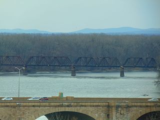
The General Pierce Bridge is a steel truss road bridge over the Connecticut River between Greenfield, Massachusetts and Montague, Massachusetts carrying Montague City Road.

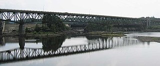
The Canalside Rail Trail Bridge is a former New York, New Haven and Hartford Railroad rail bridge across the Connecticut River between Deerfield and Montague, Massachusetts. The bridge is on the Massachusetts Historic Bridge Inventory as a "Historic Metal Truss Bridge", currently the sixth oldest metal truss bridge on the state-wide historic registry. The Canalside Rail Trail, completed in Spring 2008, incorporates this bridge.
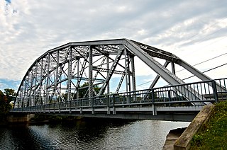
The Turners Falls–Gill Bridge, is a steel deck truss bridge crossing the Connecticut River in Massachusetts. It connects the Town of Gill with the village of Turners Falls in the Town of Montague. The bridge carries automobile and pedestrian traffic.

The Willimansett Bridge is a steel truss bridge over the Connecticut River located between Chicopee, Massachusetts and Holyoke, Massachusetts. It carries Massachusetts state routes 116 and 141.

The West Cornwall Covered Bridge is a wooden covered lattice truss bridge carrying the Sharon-Goshen Turnpike over the Housatonic River in the town of Cornwall, Connecticut. Records indicate that a bridge may have been in place in this location as early as 1762. A previous bridge was destroyed in the flood of 1837 and a new bridge was constructed in 1841. This bridge would also be destroyed and the current bridge would be completed circa 1864. Utilizing the central pier from the previous incarnation, despite the Town lattice being able to withstand the weight and single span, the bridge has two spans. The later addition of queen trusses and supports gives the bridge an unusual appearance. Modernization of the bridge in 1968 and 1973 has continued to let the bridge handle traffic. It was added to the National Register of Historic Places in 1975.

The Bellows Falls Arch Bridge was a three-hinged steel through arch bridge over the Connecticut River between Bellows Falls, Vermont and North Walpole, New Hampshire. It was structurally significant as the longest arch bridge in the United States when it was completed in 1905.

The Butts Bridge carries Butts Bridge Road over the Quinebaug River in the town of Canterbury, Connecticut. It is a well-preserved example of a Parker truss, built in 1937, late in the state's regular use of steel truss bridge designs. The bridge is also known as Bridge No. 1649 and carries an average of 2,300 vehicles per day as of 2011. It was listed on the National Register of Historic Places in 2010.
The Piermont Bridge carries New Hampshire Route 25 over the Connecticut River between Piermont, New Hampshire and Bradford, Vermont. It is a Pennsylvania steel through truss bridge, built by the Boston Bridge Works in 1928. The bridge consists of a single span with a clear span of 352' and an overall length of 354'10". The roadbed is 20'7" wide, with a vertical clearance of 14'7". The bridge is approximately 25' above the river. The western (Vermont) abutment is made of split granite quarried from nearby Fairlee Mountain, while the eastern abutment is an early concrete construction built in 1908 by John Storrs for an earlier bridge. The bridge underwent a major renovation in 1993 which included the addition of a sidewalk and replacement of much of the bridge decking.

The Ranger Bridge between Wells River, Vermont and Woodsville, New Hampshire, is a three-hinged steel arch truss bridge over the Connecticut River. It was built in 1923 to replace a 1917 bridge. This is the oldest steel arch bridge over the Connecticut River.

The Lyme–East Thetford Bridge is a historic bridge over the Connecticut River between Lyme, New Hampshire, and East Thetford, Vermont. From the New Hampshire side it carries East Thetford Road, which becomes Vermont Route 113 as it enters Vermont. A Parker truss bridge completed in 1937, it is 471 feet (144 m) long. The bridge was added to the National Register of Historic Places in 2020.


