Portland, Connecticut

Last updated
Portland, Connecticut
Town of Portland
Portland Main Street facing town hall, 2022-4-15.jpg
Main Street in Portland facing toward the town hall
PortlandCTseal.jpg
Nickname: 
Quarry Town
Portland, Connecticut
Coordinates: 41°34′21″N72°38′26″W / 41.57250°N 72.64056°W / 41.57250; -72.64056 Coordinates: 41°34′21″N72°38′26″W / 41.57250°N 72.64056°W / 41.57250; -72.64056
CountryFlag of the United States.svg  United States
U.S. state Flag of Connecticut.svg  Connecticut
County Middlesex
Region Lower CT River Valley
Incorporated1841
Government
  Type Selectman-town meeting
Area
  Total64.5 km2 (24.9 sq mi)
  Land60.6 km2 (23.4 sq mi)
  Water3.8 km2 (1.5 sq mi)
Elevation
[1]
48 m (157 ft)
Population
 (2020)
  Total9,384
  Density154.9/km2 (401/sq mi)
Time zone UTC-5 (Eastern)
  Summer (DST) UTC-4 (Eastern)
ZIP code
06480
Area code(s) 860/959
FIPS code 09-61800
GNIS feature ID0213491 [1]
Website http://www.portlandct.org/

Portland is a town in Middlesex County, Connecticut, United States. The town is part of the Lower Connecticut River Valley Planning Region. The population was 9,384 at the 2020 census. [2] The town center is listed as a census-designated place (CDP). It is situated across the Connecticut River from Middletown.

Contents

Brownstone quarried in Portland was used in the construction of Hartford's Old State House in 1796. The vast majority of the brownstone buildings in Connecticut (see College Row at Wesleyan University and the Long Walk at Trinity College) as well as the famous brownstones in New York City were built with brownstone from Portland's quarries. Later, one of the quarries was transformed into an adventure park in the summer months featuring zip lines, cliff diving and scuba locations.

About half of the town's perimeter is made up of the Connecticut River. The town has eight marinas and boat clubs as well as three 18-hole golf courses. [3]

History

The Wangunk tribe lived in the area prior to European settlement, and lived in Portland continuously throughout the settler period. Wangunk descendants still live in the area today. Their name referred to the bend in the Connecticut River which curves around half of the town's perimeter. [3]

Settlement to the nineteenth century

The first European settlers came to Portland in the 1690s. They were attracted by brownstone, which was used both for construction and for gravestones. Proximity to the river meant that the stone could be transported far and wide, and the Portland brownstone quarries supplied to New York, Boston and even San Francisco, Canada and England. By the 1850s, more than 1,500 people were employed in the quarry industry. More than 25 ships transported the stone. By the 1850s, shipbuilding became more important as an industry, and the economic center of town shifted toward the Gildersleeve area. Immigrants from Ireland, then Sweden, then (to a lesser extent) Italy came to town to work the quarries. [3]

It originally was part of Middletown and then known as East Middletown. In 1767, Chatham, which then included Portland and East Hampton, was founded. [4]

The town was a part of Chatham until 1841, when it became separate. Its name comes from Portland, England, a place famous for its freestone quarries. [5]

Portland's oldest church is the First Congregational Church. In 1710 a meeting was held for the building of a meetinghouse for preaching. The Connecticut General Assembly approved "parish privileges" in 1714. After a vociferous controversy, a location for the new "Third Ecclesiastical Society of Middletown" meetinghouse was decided upon at "Hall Hill". On October 25, 1721, Rev. Daniel Newell, the first pastor, was ordained. The Bristol, Connecticut native and Yale College graduate died in 1731. In 1748 a new meetinghouse was built, and in 1843 the name of the society was changed to the "First Ecclesiastical Society of Portland." [5]

Late nineteenth and twentieth centuries

Brownstone quarry, c. 1911 PostcardPortlandCTBrownstoneQuarry1911.jpg
Brownstone quarry, c.1911

Before quarrying became the town's chief industry in the nineteenth century, Portland was known for its shipbuilding. The Gildersleeve village in town is associated with the Gildersleeve family, prominent shipbuilders in the 1800s. The first vessel built in town was launched in 1741. During the American Revolution and the War of 1812 many U.S. Navy vessels were built in various shipyards in town. Tinware and enamelware were produced in town in the late nineteenth century. [5] Tobacco farming has also been a big industry in the town. [6] During the American Civil War a number of vessels were also constructed in Portland, such as the steamship USS Guard (1857) and the bark USS J. C. Kuhn (1859).

In 1895, the town decided to establish a public library, although private libraries had been in town for more than a century. The Portland Library was originally a room in Town Hall with about 800 books after the private Portland Library Association turned over all of its books. Within months of its establishment, Horace B. Buck, a native resident who later moved to Worcester, Massachusetts, donated $2,000 toward the erection of a separate library building, and the town appropriated another $1,000. Shaler & Hall and Brainerd Quarries contributed the brownstone, and before the building was finished, Buck gave another $500 (after his death, his estate gave another $2,500). The library moved into another building in 1981. [4] [5]

In the early twentieth century, brownstone couldn't compete much with concrete, and the industry went into decline. In 1936, the Connecticut River flooded the quarries effectively ending the industry in town. [3] Shipbuilding also collapsed at this time. [3]

Education

The Portland Public School District consists of four schools: Portland High School & Middle School, Brownstone Intermediate School, Gildersleeve School and Valley View School. The district serves a total of 1,425 students. [7]

In the early eighteenth and nineteenth centuries, schools were managed by school societies. These societies were abolished when the first Board of Education was elected in 1856. The area was divided into school districts. [8]

Gildersleeve Hall, District 1, was built in 1876 and located on Main Street. It offered both elementary and high school. It was the first high school conducted in any town in Connecticut. When fire destroyed it in 1889, it was rebuilt on the same site. It continued to offer high school until 1899. It served students until 1958. It was demolished to make room for the third school on the site. Gildersleeve School opened in 1964 and still stands at 575 ½ Main Street. [8] It now serves grades 3 and 4. [9]

Central School, 1907. Originally the High School, it now houses the Town Hall and Board of Education. PostcardHighSchoolPortlandCT1907.jpg
Central School, 1907. Originally the High School, it now houses the Town Hall and Board of Education.

Central School District, District 2, included several schools between 1830–1979. The only remaining building is the Central School Building that is now the Town Hall located at 33 East Main Street. The Central School Building originally named Portland High School, offered high school courses in 1890 to 7 pupils. It consolidated with Gildersleeve High School in 1899. [8] It remained a school building until 1979. It became the Town hall in 2001. [10]

District 3 was located on Rose Hill Road opposite the residence of Walter W Olsen. The Rose Hill School was the first school building in Portland and used until 1936. District 4, Penfield Hill School, 1830–1920, is now owned by Noyes School. District 5, Up City School, 1857–1921, on Glastonbury Road is now a residence. District 6, Pecausett School, 1830–1911, was located at the southwest corner of Grove Street and East Hampton Road. District 7, the Bucktown School, 1830–1872, was built on the eastern end of Cotton Hill Road. [8]

The school currently known as the Brownstone Intermediate School, located at 314 Main Street, was opened in 1932 as the Junior-Senior High School. It was open to grades 7–12. Renovations were made to the school in 1953 and 1967. [11] In 1960, it was renamed Portland Junior High School and then renamed again in 1989 to Portland Middle School where it housed grades 6 through 8. In 2004, it was renamed Brownstone Intermediate School and now houses grades 5 and 6. [12] [13]

Valley View Elementary School located at 81 High Street opened in 1954. An addition was complete in 1958. [14] Valley View currently houses grades K–2. [13]

Portland High School located at 95 High Street opened in 1960 as the new Senior High School. A large addition was completed in 1969 [14] Renovations and a second addition were made to the high school and completed in 2004. The project included a large addition that houses the new Portland Middle School at 93 High Street. [12] The middle school includes grades 7 and 8. [9]

Geography

According to the United States Census Bureau, the town has a total area of 24.9 square miles (64 km2), of which, 23.4 square miles (61 km2) of it is land and 1.5 square miles (3.9 km2) of it (5.99%) is water. The town center CDP has a total area of 5.5 square miles (14 km2). 4.9 square miles (13 km2) of it is land and 0.5 square miles (1.3 km2) of it (9.71%) is water. The village of Gildersleeve also lies within Portland.

Climate data for Portland, Connecticut
MonthJanFebMarAprMayJunJulAugSepOctNovDecYear
Record high °F (°C)70
(21)
74
(23)
86
(30)
93
(34)
99
(37)
100
(38)
101
(38)
102
(39)
101
(38)
89
(32)
83
(28)
75
(24)
102
(39)
Average high °F (°C)36
(2)
39
(4)
48
(9)
60
(16)
70
(21)
79
(26)
84
(29)
82
(28)
75
(24)
63
(17)
52
(11)
41
(5)
61
(16)
Average low °F (°C)18
(−8)
22
(−6)
29
(−2)
40
(4)
49
(9)
59
(15)
65
(18)
63
(17)
54
(12)
42
(6)
35
(2)
24
(−4)
42
(5)
Record low °F (°C)−17
(−27)
−24
(−31)
−4
(−20)
11
(−12)
25
(−4)
39
(4)
45
(7)
38
(3)
29
(−2)
18
(−8)
5
(−15)
−12
(−24)
−24
(−31)
Average precipitation inches (mm)3.15
(80)
2.75
(70)
3.57
(91)
3.88
(99)
3.89
(99)
3.99
(101)
4.00
(102)
3.66
(93)
3.48
(88)
4.14
(105)
3.84
(98)
3.35
(85)
43.7
(1,111)
Source: [15]

Demographics

Historical population
CensusPop.Note
1850 2,836
1860 3,65728.9%
1870 4,69328.3%
1880 4,157−11.4%
1890 4,68712.7%
1900 3,856−17.7%
1910 3,425−11.2%
1920 3,6446.4%
1930 3,9307.8%
1940 4,3219.9%
1950 5,18620.0%
1960 7,49644.5%
1970 8,81217.6%
1980 8,383−4.9%
1990 8,4180.4%
2000 8,7323.7%
2010 9,5088.9%
2020 9,384−1.3%
U.S. Decennial Census [16]
Willow Island, 1910 postcard PostcardWillowIslandPortlandCt1910.jpg
Willow Island, 1910 postcard

At the 2000 census there were 8,732 people in 3,388 households, including 2,419 families, in the town. The population density was 373.1 inhabitants per square mile (144.1/km2). There were 3,528 housing units at an average density of 150.7 per square mile (58.2/km2). The racial makeup of the town was 95.12% White, 2.44% Black or African American, 0.16% Native American, 0.52% Asian, 0.03% Pacific Islander, 0.46% from other races, and 1.27% from two or more races. Hispanic or Latino of any race were 1.96%. [17]

Of the 3,388 households 33.6% had children under the age of 18 living with them, 58.5% were married couples living together, 9.4% had a female householder with no husband present, and 28.6% were non-families. 24.1% of households were one person and 10.4% were one person aged 65 or older. The average household size was 2.52 and the average family size was 3.01.

The age distribution was 25.5% under the age of 18, 4.5% from 18 to 24, 30.7% from 25 to 44, 24.7% from 45 to 64, and 14.6% 65 or older. The median age was 39 years. For every 100 females, there were 95.0 males. For every 100 females age 18 and over, there were 91.4 males.

The median household income was $63,285 and the median family income was $73,036. Males had a median income of $48,849 versus $35,104 for females. The per capita income for the town was $28,229. About 3.0% of families and 5.1% of the population were below the poverty line, including 4.6% of those under age 18 and 8.9% of those age 65 or over.

Town center

At the 2000 census there were 5,534 people in 2,225 households, including 1,495 families, in the Portland census-designated place, comprising the town center and the adjacent neighborhood of Gildersleeve. The population density was 1,121.8 inhabitants per square mile (433.1/km2). There were 2,286 housing units at an average density of 463.4 per square mile (178.9/km2). The racial makeup of the CDP was 93.89% White, 3.22% Black or African American, 0.22% Native American, 0.54% Asian, 0.05% Pacific Islander, 0.56% from other races, and 1.52% from two or more races. Hispanic or Latino of any race were 2.29%. [17]

Of the 2,225 households 29.8% had children under the age of 18 living with them, 51.4% were married couples living together, 11.4% had a female householder with no husband present, and 32.8% were non-families. 28.3% of households were one person and 13.0% were one person aged 65 or older. The average household size was 2.39 and the average family size was 2.94.

The age distribution was 23.7% under the age of 18, 5.1% from 18 to 24, 29.5% from 25 to 44, 23.9% from 45 to 64, and 17.9% 65 or older. The median age was 40 years. For every 100 females, there were 92.7 males. For every 100 females age 18 and over, there were 87.6 males.

The median household income was $55,949 and the median family income was $66,686. Males had a median income of $46,163 versus $30,402 for females. The per capita income for the CDP was $26,240. About 4.1% of families and 6.7% of the population were below the poverty line, including 5.8% of those under age 18 and 11.8% of those age 65 or over.

Notable locations

The Arrigoni Bridge as seen from near the Portland town center Arrigoni Bridge from Portland, 2022-4-15.jpg
The Arrigoni Bridge as seen from near the Portland town center

Notable people

Related Research Articles

<span class="mw-page-title-main">Longmeadow, Massachusetts</span> Town in Massachusetts, United States

Longmeadow is a town in Hampden County, Massachusetts, in the United States. The population was 15,853 at the 2020 census.

<span class="mw-page-title-main">Hartford County, Connecticut</span> County in Connecticut, United States

Hartford County is a county located in the north central part of the U.S. state of Connecticut. According to the 2020 census, the population was 899,498, making it the second-most populous county in Connecticut. Hartford County contains the city of Hartford, the state capital of Connecticut and the county's most populous city, with 121,054 residents at the 2020 census. Hartford County is included in the Hartford-East Hartford-Middletown metropolitan statistical area.

<span class="mw-page-title-main">Middlesex County, Connecticut</span> County in Connecticut, United States

Middlesex County is a county in the south central part of the U.S. state of Connecticut. As of the 2020 census, the population was 164,245. The county was created in May 1785 from portions of Hartford County and New London County.

<span class="mw-page-title-main">Rocky Hill, Connecticut</span> Town in Connecticut, United States

Rocky Hill is a town in Hartford County, Connecticut, United States. The population was 20,845 at the 2020 census. It was originally land of the Wangunks. Europeans began to settle the area of Rocky Hill in 1650, as part of Wethersfield, the neighboring town to the north. In 1722, the area became known as Stepney Parish, until it was independently incorporated in 1843. Rocky Hill’s location on the Connecticut River made it a natural port for Wethersfield and an early center for shipbuilding, agriculture, and trade.

<span class="mw-page-title-main">Winsted, Connecticut</span> CDP in Connecticut, United States

Winsted is a census-designated place and an incorporated city in Litchfield County, Connecticut, United States. It is part of the town of Winchester. The population of Winsted was 7,712 at the 2010 census, out of 11,242 in the entire town of Winchester. Winsted is part of the Northwest Hills Planning Region.

<span class="mw-page-title-main">Cromwell, Connecticut</span> Town in Connecticut, United States

Cromwell is a town in Middlesex County, Connecticut, United States located in the middle of the state. The town is part of the Lower Connecticut River Valley Planning Region. The population was 14,225 at the 2020 census.

<span class="mw-page-title-main">East Haddam, Connecticut</span> Town in Connecticut, United States

East Haddam is a town in Middlesex County, Connecticut. The town is part of the Lower Connecticut River Valley Planning Region. The population was 8,875 at the time of the 2020 census.

<span class="mw-page-title-main">Higganum, Connecticut</span> Census-designated place in Connecticut, United States

Higganum is a village and census-designated place (CDP) in the town of Haddam, a part of Middlesex County, Connecticut, United States. The population was 2,089 at the 2020 census.

<span class="mw-page-title-main">Middlefield, Connecticut</span> Town in Connecticut, United States

Middlefield is a town in Middlesex County, Connecticut, United States. The town is part of the Lower Connecticut River Valley Planning Region. The population was 4,217 at the 2020 census. The town includes the village of Rockfall in the northeast section.

<span class="mw-page-title-main">Rockville, Connecticut</span> Census-designated place in Connecticut, United States

Rockville is a census-designated place and a village of the town of Vernon in Tolland County, Connecticut, United States. The population was 7,474 at the 2010 census. Incorporated as a city in 1889, it has been consolidated with the town of Vernon since 1965.

<span class="mw-page-title-main">Vernon, Connecticut</span> Town in Connecticut, United States

Vernon is the most populous town in Tolland County, Connecticut, United States. The population was 30,215 at the 2020 census. Vernon contains the smaller villages of Talcottville and Dobsonville. Vernon contains the former City of Rockville.

<span class="mw-page-title-main">Mahomet, Illinois</span> Village in Illinois, United States

Mahomet is a village in Champaign County, Illinois, United States. The population was 9,434 at the 2020 census. Mahomet is located approximately 10 miles northwest of Champaign at the junction of Interstate 74 and IL 47.

<span class="mw-page-title-main">Middletown, Illinois</span> Village in Illinois, United States

Middletown is a village in Logan County, Illinois, United States. The population was 324 at the 2010 census, down from 434 in 2000.

<span class="mw-page-title-main">Middletown, Indiana</span> Town in Indiana, United States

Middletown is a town in northwest Henry County, Indiana, United States. The population was 2,322 at the 2010 census.

<span class="mw-page-title-main">East Longmeadow, Massachusetts</span> City in Massachusetts, United States

East Longmeadow is a town in Hampden County, Massachusetts, United States situated in the Pioneer Valley region of Western Massachusetts. It had a population of 16,430 at the 2020 census. East Longmeadow is 5 mi (8.0 km) southeast of downtown Springfield, part of the Springfield Metropolitan Statistical Area. Additionally, the town is 25 mi (40 km) north of Hartford, 88 mi (142 km) southwest of Boston, and 142 mi (229 km) northeast of New York City.

<span class="mw-page-title-main">Berea, Ohio</span> City in Ohio, United States

Berea is a city in Cuyahoga County in the U.S. state of Ohio and is a western suburb of Cleveland. The population was 19,093 at the 2010 census. Berea is home to Baldwin Wallace University, as well as the training facility for the Cleveland Browns and the Cuyahoga County Fairgrounds. Also near Berea is the Cleveland Hopkins International Airport.

<span class="mw-page-title-main">Hummelstown, Pennsylvania</span> Borough in Pennsylvania, United States

Hummelstown is a borough in Dauphin County, Pennsylvania, United States. The population was 4,535 as of the 2020 census. It is part of the Harrisburg–Carlisle Metropolitan Statistical Area.

<span class="mw-page-title-main">Middletown, Dauphin County, Pennsylvania</span> Borough in Pennsylvania, United States

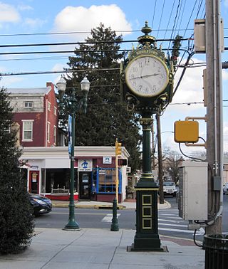
Middletown is a borough in Dauphin County, Pennsylvania, on the Susquehanna River, 10 miles (16 km) southeast of Harrisburg. As of the 2020 census, it had a population of 9,550. It is part of the Harrisburg–Carlisle Metropolitan Statistical Area.

<span class="mw-page-title-main">Middletown, Connecticut</span> City in Connecticut, United States

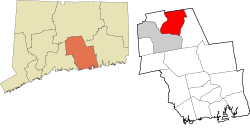
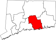
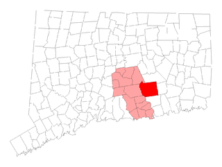
Middletown is a city in Middlesex County, Connecticut, United States. Located along the Connecticut River, in the central part of the state, it is 16 miles south of Hartford. Middletown is the largest city in the Lower Connecticut River Valley Planning Region. In 1650, it was incorporated by English settlers as a town under its original Native American name, Mattabeseck, after the local indigenous people, also known as the Mattabesett. They were among the many tribes along the Atlantic coast who spoke Algonquian languages. The colonists renamed the settlement in 1653.

<span class="mw-page-title-main">East Hampton, Connecticut</span> Town in Connecticut, United States

East Hampton is a town in Middlesex County, Connecticut, United States. The town is part of the Lower Connecticut River Valley Planning Region. The population was 12,717 at the 2020 census. The town center village is listed as a census-designated place (CDP). East Hampton includes the communities of Cobalt, Middle Haddam, and Lake Pocotopaug.

References

  1. 1 2 U.S. Geological Survey Geographic Names Information System: Portland, Connecticut
  2. "Census - Geography Profile: Portland town, Middlesex County, Connecticut" . Retrieved December 20, 2021.
  3. 1 2 3 4 5 "Portland Library - Index". Archived from the original on 2007-07-05. Retrieved 2007-07-10. Web page titled "Portland, Connecticut" at the "Portland Online" Web site of the Town of Portland, accessed July 10, 2007
  4. 1 2 "Portland Library - Index". Archived from the original on 2007-07-05. Retrieved 2007-07-10."History of the Portland Library" Web page at the Web site of the Portland Library, accessed July 10, 2007
  5. 1 2 3 4 "History 1896". Archived from the original on 2007-07-15. Retrieved 2007-07-10."Portland 1896 / (an Introduction)" Web page reprinting an article from a "Souvenir Edition of The Middletown Tribune, dated 1896", at the official town Web site, accessed July 10, 2007
  6. "Portland Library - Index". Archived from the original on 2007-07-05. Retrieved 2007-07-10. Web page titled "Portland Online" at the Town of Portland Web site, accessed July 10, 2007
  7. "About Portland". Archived from the original on 2007-09-28. Retrieved 2007-07-10. Web page titled "About" at the Web site of the Portland Public School District, accessed July 10, 2007
  8. 1 2 3 4 History of Portland Connecticut, 1976. Portland Historical Society, 1976.
  9. 1 2 "National Center for Education Statistics" Retrieved on 2011-2-2.
  10. Images of America Portland. Robert W. McDougall. Arcadia, Charleston, SC, 2004.
  11. History of Portland Connecticut. Portland Historical Society, 1976
  12. 1 2 Mill, Jeff. "Proposed 2004-2005 School Budget up 13.2 Percent", Middletown Press , 2004-1-7. Retrieved on 2011-2-2.
  13. 1 2 "National Center for Education Statistics" Retrieved on 2011-2-2
  14. 1 2 History of Portland Connecticut, 1976. Portland Historical Society, 1976
  15. "Monthly Averages for Portland, CT (06480)". Weather.com. Retrieved March 19, 2012.
  16. "Census of Population and Housing". Census.gov. Retrieved June 4, 2015.
  17. 1 2 "U.S. Census website". United States Census Bureau . Retrieved 2008-01-31.
  18. "Brownstone Exploration and Discovery Park". Brownstone Park. Brownstone Park. Retrieved 11 October 2015.