Portland (CDP), Connecticut

Last updated

Portland, Connecticut
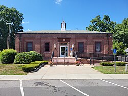
Post Office, Portland CT.jpg
Post Office
USA Connecticut location map.svg
Red pog.svg
Portland
Usa edcp location map.svg
Red pog.svg
Portland
Coordinates: 41°34′44″N72°37′54″W / 41.57889°N 72.63167°W / 41.57889; -72.63167
Country Flag of the United States.svg  United States
State Connecticut
County Middlesex
Town Portland
Area
[1]
  Total17.16 km2 (6.63 sq mi)
  Land15.53 km2 (6.00 sq mi)
  Water1.63 km2 (0.63 sq mi)
Elevation
[2]
50 m (170 ft)
Population
 (2020) [3]
  Total5,813
  Density374.4/km2 (970/sq mi)
Time zone UTC-5 (Eastern (EST))
  Summer (DST) UTC-4 (EDT)
ZIP Code
06480
Area code(s) 860/959
FIPS code 09-61870
GNIS feature ID2377853 [2]

Portland is a census-designated place (CDP) comprising the primary village and adjacent residential land in the town of Portland, Middlesex County, Connecticut, United States. It is in the southwest part of the town, bordered to the west and south by the Connecticut River, which forms the border with Cromwell to the west and Middletown to the south. The Portland CDP extends north along Main Street (Connecticut Route 17A) to its junction with Gospel Lane (Connecticut Route 17) at Fogelmarks Corners, and the eastern extent of the CDP is at Rose Hill Road and Collins Hill Road. The CDP includes the neighborhood of Gildersleeve in the north.

As of the 2020 census, the CDP had a population of 5,813, [3] out of 9,384 in the entire town of Portland.

Related Research Articles

<span class="mw-page-title-main">Essex Village, Connecticut</span> Census-designated place in Connecticut, United States

Essex Village is a village and census-designated place (CDP) in the town of Essex, Connecticut, in the United States. The population was 2,583 at the 2020 census, out of 6,733 in the entire town of Essex. The government offices of the town are located within the village.

<span class="mw-page-title-main">Simsbury Center, Connecticut</span> Census-designated place in Connecticut, United States

Simsbury Center is a census-designated place (CDP) that consists of the central settlement, and the neighborhoods immediately surrounding it, in the town of Simsbury, Connecticut, in the United States. As of the 2010 census, the CDP had a population of 5,836. The core area of the CDP is listed as the Simsbury Center Historic District on the National Register of Historic Places.

<span class="mw-page-title-main">Bethel (CDP), Connecticut</span> Census-designated place in Connecticut, United States

Bethel is a census-designated place (CDP) in Fairfield County, Connecticut, United States. It comprises the primary village and surrounding residential land within the town of Bethel. As of the 2010 census, the population of the CDP was 9,549, out of 18,584 in the entire town.

<span class="mw-page-title-main">Ridgefield (CDP), Connecticut</span> Census-designated place in Connecticut, United States

Ridgefield is a census-designated place (CDP) in Fairfield County, Connecticut, United States. It consists of the primary central village in the town of Ridgefield and surrounding residential areas. As of the 2020 census, the population of the CDP was 7,596, out of 25,053 in the entire town.

Hanover is a census-designated place (CDP) and the main village in the town of Hanover in Grafton County, New Hampshire, United States. The population of the CDP was 9,078 at the 2020 census, out of 11,870 in the entire town. The CDP includes the campus of Dartmouth College.

<span class="mw-page-title-main">Hampton (CDP), New Hampshire</span> Census-designated place in New Hampshire, United States

Hampton is a census-designated place (CDP) comprising the town center and surrounding developed areas of the town of Hampton, Rockingham County, New Hampshire, United States. The population of the CDP was 9,597 at the 2020 census, out of 16,214 in the entire town.

<span class="mw-page-title-main">Bethlehem Village, Connecticut</span> Census-designated place in Connecticut, United States

Bethlehem Village is a census-designated place (CDP) within the town of Bethlehem in Litchfield County, Connecticut, United States. The CDP includes the Bethlehem Green Historic District at the town center, as well as surrounding residential and rural land. As of the 2010 census, the CDP had a population of 2,021, out of a population of 3,607 for the entire town of Bethlehem.

Saugatuck is a census-designated place (CDP) in the town of Westport, Fairfield County, Connecticut, United States. It is in the southwest part of the town, on both sides of the Saugatuck River, extending south to where it enters Long Island Sound. North of Interstate 95, it occupies just the west side of the Saugatuck and continues north as far as U.S. Route 1. It is bordered to the north by Westport Village and to the west by the city of Norwalk. The CDP includes the communities of Owenoke and Saugatuck Shores, as well as the Metro-North Railroad Westport station.

<span class="mw-page-title-main">Wallingford Center, Connecticut</span> Census-designated place in Connecticut, United States

Wallingford Center is a census-designated place (CDP) comprising the primary community in the town of Wallingford, New Haven County, Connecticut, United States. It is in the central and southern parts of the town, bordered to the west by the Wilbur Cross Parkway, to the east by Interstate 91, and to the south by the town of North Haven. To the north the CDP extends to New Rock Hill Road, Durham Road, Christian Street, North Elm Street, Maplewood Avenue, and up North Main Street as far as Yale Avenue, where it crosses the Wilbur Cross Parkway. U.S. Route 5 is the main north–south road through the community. To the north is the neighborhood of Yalesville.

Westbrook Center is a census-designated place (CDP) comprising the primary village and adjacent residential land in the town of Westbrook, Middlesex County, Connecticut, United States. It is in the southern part of the town, along U.S. Route 1 and bordered to the south by Long Island Sound. To the east it is bordered by the town of Old Saybrook, and the west and northwest border of the CDP is the Patchogue River. As of the 2020 census, the CDP had a population of 2,220, out of 6,769 in the entire town of Westbrook.

Fivepointville is an unincorporated community and census-designated place (CDP) in Brecknock Township, Lancaster County, Pennsylvania, United States. As of the 2010 census, the population was 1,156. The town is named for its position at an intersection of five separate roads.

<span class="mw-page-title-main">Wilton Center, Connecticut</span> Census-designated place in Connecticut, United States

Wilton Center is a neighborhood/section and census-designated place (CDP) in the town of Wilton in Fairfield County, Connecticut, United States. As of the 2010 census it had a population of 732. The CDP partially overlaps the Wilton Center Historic District.

<span class="mw-page-title-main">Colebrook (CDP), New Hampshire</span> Census-designated place in New Hampshire, United States

Colebrook is a census-designated place (CDP) and the main village in the town of Colebrook, Coös County, New Hampshire, United States. The population of the CDP was 1,201 at the 2020 census, out of 2,084 in the entire town. The CDP population had dropped from 1,394 at the 2010 census.

<span class="mw-page-title-main">Walpole (CDP), New Hampshire</span> Census-designated place in New Hampshire, United States

Walpole is a census-designated place (CDP) and the central village in the town of Walpole in Cheshire County, New Hampshire, United States. The population of the CDP was 573 at the 2020 census, compared to 3,633 in the entire town.

<span class="mw-page-title-main">Canaan (village), Connecticut</span> United States historic place

Canaan is a village and census-designated place (CDP) within the town of North Canaan in Litchfield County, Connecticut, United States. Formerly known as Canaan Depot, the village is more commonly known as Canaan Village to distinguish it from the town of Canaan located to the south of North Canaan. The Canaan Village Historic District is listed on the National Register of Historic Places. As of the 2010 census, the CDP had a population of 1,212, out of a total population of 3,315 in the town of North Canaan.

Groveland Station is a census-designated place (CDP) in Livingston County, New York, United States. The CDP consists of the hamlet of Groveland and nearby residential areas. The CDP population was 281 as of the 2010 census. New York State Route 63 passes through the community.

<span class="mw-page-title-main">Watertown (CDP), Connecticut</span> Census-designated place in Connecticut, United States

Watertown is a census-designated place (CDP) in Litchfield County, Connecticut, United States. It comprises the central village of the town of Watertown. As of the 2010 census, the population of the CDP was 3,574, out of 22,514 in the entire town. As of the 2020 Census, the population was 22,105.

Staples is a census-designated place (CDP) in the town of Westport, Fairfield County, Connecticut, United States. It occupies the eastern side of the town and is bordered to the north by Cross Highway, to the west by Compo Road, to the south by U.S. Route 1, and to the east by the town of Fairfield.

Plattsville is a census-designated place (CDP) in the towns of Easton and Fairfield, Fairfield County, Connecticut, United States. It is primarily in the town of Easton, with a portion extending south across the Mill River into Fairfield. The Merritt Parkway forms the southeast border of the CDP, and Connecticut Route 59 runs north–south through it.

Chestnut Hill is an unincorporated community and census-designated place (CDP) in Northampton County, Pennsylvania. It was first listed as a CDP prior to the 2020 census. Its population as of the 2020 census was 6,689. It is part of the Lehigh Valley metropolitan area, which had a population of 861,899 and was the 68th-most populous metropolitan area in the U.S. as of 2020.

References

  1. "2022 U.S. Gazetteer Files: Connecticut". United States Census Bureau. Retrieved December 12, 2022.
  2. 1 2 "Portland Census Designated Place". Geographic Names Information System . United States Geological Survey, United States Department of the Interior.
  3. 1 2 "P1. Race – Portland CDP, Connecticut: 2020 DEC Redistricting Data (PL 94-171)". U.S. Census Bureau. Retrieved December 12, 2022.