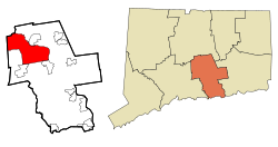
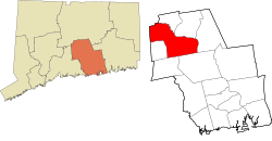
Middletown is a city in Middlesex County, Connecticut, United States. Located along the Connecticut River, in the central part of the state, 16 miles (25.749504 km) south of Hartford. Middletown is the largest city in the Lower Connecticut River Valley Planning Region. In 1650, it was incorporated by English settlers as a town under its original Native American name, Mattabeseck, after the local Wangunk village of the same name. They were among many tribes along the Atlantic coast who spoke Algonquian languages. The colonists renamed the settlement in 1653.
When Hartford County was organized on May 10, 1666, Middletown was included within its boundaries. In 1784, the central settlement was incorporated as a city distinct from the town. Both were included within newly formed Middlesex County in May 1785. In 1923, the City of Middletown was consolidated with the Town, making the city limits extensive.
Originally developed as a sailing port and then an industrial center on the Connecticut River, it is now largely residential. Its downtown, based on Main Street, serves as a popular retail, dining, and bar district near Wesleyan University. Middletown was the county seat of Middlesex County from its creation in 1785 until the elimination of county government in 1960. As of the 2020 census, the city had a total population of 47,717. Middletown, Connecticut is considered the southernmost city in the Hartford-SpringfieldKnowledge Corridor Metropolitan Region, which features a combined metro population of 1.9 million. Middletown is largely a politically progressive city, and is home to one of the largest pride events in all of Connecticut.[4]
The land on the western bank of the Connecticut River where Middletown now lies was home to a village of the Wangunk, a tribe of Algongquian-speaking Native Americans. The village was named Mattabesset (also spelled Mattabesett, Mattabesec,Mattabeseck, and Mattabesek); the area they inhabited—now Middletown and the surrounding area—was named after it. When the primarily-English European settlers arrived in the region the Mattabesset were a part of the Wangunk, a large tribe in the Connecticut Valley, at the time under a sachem named Sowheag.[5][6]
Plans for the colonial settlement were drawn up by the General Court in 1646; the first migrants came from nearby Connecticut colonies in 1650. On September 11, 1651, the General Court of Connecticut established the town of "Mattabesett". A couple of years later in November 1653, the settlement was renamed as Middletown. This name was chosen because the site was approximately halfway between Windsor and Saybrook on the Great River. Life was not easy for these early colonial Puritans; clearing the land and building houses, and tending farms in the rocky soil of New England was a labor-intensive ordeal. They had a strict society; offenses legally punishable by death in the Connecticut colonies included "witchcraft, blasphemy, cursing or smiting of parents, and incorrigible stubbornness of children."[5][6]
The PequotMohegan, at that time traditional allies of the English colonists and enemies of the Wangunk, arrived in the Middletown area in the latter half of the 17th century; conflict between them and local Native American tribes ensued. The inhabitants of Mattabesett and others referred to the Mohegan as "destroyers of men." Sowheag hoped that the colonists would intervene. They did not. Smallpox epidemics caused high mortality, reducing their ability to resist and disrupting their cohesion as a tribe. Records show that, over time, Sowheag was forced to sell off most of Mattabesett to the local colonists; by 1676 the Puritans owned all but 300 acres (1.2km2) of the former territory.[6] Native Americans suffered similar fates of illness and dispossession at other colonial sites in 17th-century New England.[7]
During the 18th century, Middletown became the largest and most prosperous settlement in Connecticut. By the time of the American Revolution, Middletown was a thriving port, where one-third of its residents were involved in merchant and maritime activities. Some settlers held enslaved Africans as workers in the early economy of Middletown; they worked as domestic servants, laborers, and in shipping. African slaves were imported by the English in 1661 from Barbados in the Caribbean. By 1756 Middletown had the third-largest African slave population in the state of Connecticut—218 slaves to 5,446 whites.[6]
Middletown merchant traders pushed for the clearance of the Saybrook Bar at the mouth of the Connecticut River, and later sought the creation of Middlesex County in 1785. The name 'Middlesex' was chosen because the intention was to make Middletown the head of a long river port, much as London was at the head of its long river port on the Thames in Middlesex County, England. The same persons also established the Middlesex Turnpike (now Route 154) to link all the settlements on the western side of the Connecticut, again with the intent of creating one long port.
After the American Revolution, Connecticut and most northern states abolished slavery. The port's decline began in the early 19th century during the period of strained American-British relations and resulting trade restrictions, which led to the War of 1812. The port never recovered from the restrictions of the war. The city's men distinguished themselves in the war effort, as Middletown's Commodore Thomas Macdonough led American forces to the victory on Lake Champlain in 1814 which ended British hopes for an invasion of New York. After the war, migration of New England families continued west to New York and, later, to the Midwest around the Great Lakes, where more land was available.
In the 19th century, Middletown became a major center for firearms manufacturing. Numerous gun manufacturers in the area supplied the majority of pistols to the United States government during the War of 1812. After that war, however, the center of this business shifted to Springfield, Massachusetts; and Hartford, and New Haven, Connecticut. (See also History of Connecticut industry.)
In 1831 Wesleyan College was established. It became one of the United States' leading liberal arts universities. The college replaced an earlier educational institution on the same site, Partridge's American Literary, Scientific and Military Academy. It had moved to Norwich, Vermont and later developed as Norwich University.
The two main buildings of the original campus were built by the people of Middletown in order to attract an academic institution to the city. In 1841, Middletown established the state's first public high school, which at first enrolled all students from age nine through age sixteen who had previously attended district schools.[8]
Home of Governor Frank Weeks, decorated for "Wesleyan Taft Day", 1909
During the mid-19th century, manufacturing replaced trade as Middletown's economic mainstay. But industrial growth was limited after railroad operators bypassed Middletown in their construction of a railway between Hartford and New Haven. There had been an ambitious plan to build a railroad suspension bridge in the White Rock, Middletown to Bodkin Rock, Portland vicinity, which was seen as an unpractical solution.
Middletonians played an active role in the American Civil War. General Joseph K. Mansfield was a Union general at the Battle of Antietam, where he died in action in 1862. Another casualty at Antietam was Brigadier General George Taylor, who had been educated at a private military academy in Middletown. The popular Civil War marching song "Marching Through Georgia" was written by Henry Clay Work, a Middletown resident. Some residents were active in the abolitionism movement, and the city was a hub along the underground railway.
Smith & Bishel Hardware on Main Street, founded in 1898
In the latter half of the 19th century, manufacturing was the mainstay of the city's economy, especially finely made metal parts, such as marine hardware (Wilcox, Crittendon & Co.) and typewriters (Royal Typewriters). There were also several machine tool & die manufacturers in the city. Middletown was the site of a major unit of Goodyear. In addition, there was the pioneer automobile manufacturer Eisenhuth Horseless Vehicle Company.[10] Other manufacturers included in national expositions and now museum collections include the Middletown Plate Company (silver),[11] Middletown Silver Co.[12] and I. E. Palmer (hammocks).[13]
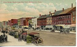
Main Street, looking north from City Hall, about 1912
In the late 19th and early 20th century, the city underwent a demographic transformation, after having been settled primarily by Protestant people from the British Isles. First the Irish, in response to the Great Famine, and then large numbers of Italian immigrants arrived to work in Middletown's factories and farms. Many of the Italians were immigrants from Melilli, Sicily.[14] Both groups were primarily Roman Catholic.
Amato's Toy and Hobby Store on Main Street, founded in 1940Looking South on Broad Street from Washington Street, 1910 postcard
Polish and German arrivals followed, and many of these immigrants were also Catholic. By 1910 the population had swelled to nearly 21,000. Meanwhile, the number of African Americans dwindled to 53 persons. Employers chose to hire white immigrants. Later in the century, more African Americans from the South migrated to the area for its industrial jobs and better social conditions. They were part of the Great Migration during the 20th century, up to 1970.
In the early 1980s, two Wesleyan professors arranged to bring a small group of Cambodian refugees to Middletown, who were exiled following the US involvement in Southeast Asia in the Vietnam War. They developed a thriving Cambodian community, as have later migrants from Tibet. Middletown also attracted Hindu immigrants from India and other parts of Southeast Asia, who established the first Hindu temple in Connecticut in Middletown.
Over the decades the new immigrants stimulated the rise of a range of cuisines offered by restaurants. This has become one of the most well-known aspects of the city.
Middletown was hit by floods in 1927 and 1936, and by The Great New England Hurricane in 1938. The Arrigoni Bridge was completed over the Connecticut River in 1938. It replaced an earlier bridge to connect Middletown to Portland and points east.
During the 1950s, as the prevalence of the automobile increased, government officials approved the construction of a highway that effectively separated Middletown from the Connecticut River, which had long supported its development. Highway construction demolished historic neighborhoods, including many buildings from the 18th century. New suburban developments were built outside older neighborhoods, attracting the people with money to buy new. In the mid-20th century, Middletown and similar towns lost heavy industry and manufacturing jobs that moved offshore, resulting in a general decline in population. An alternate economy began to develop by the 1990s.
During this period, the city tore down many older buildings in the name of 'urban renewal', but sometimes new development was delayed for years. Downtown area had large flat parking lots, or buildings were abandoned and left empty. With high unemployment and limited opportunities, and increasing problems with drugs, crime increased. During the 1960s, Pratt & Whitney opened a large aircraft engine plant in the Maromas section of Middletown. Concurrently, developers bought much of the city's remaining farms, including most of Oak Grove Dairy, to redevelop as residential suburbs for local workers and commuters to surrounding cities.
During the 1970s, Oddfellows Playhouse was established. The theater attracts hundreds of young people every year from around the state to perform in plays and other performances. The playhouse is one of the few youth theaters in the state of Connecticut. It is located on 128 Washington Street, around the corner from Middletown's Main Street.
During the 1990s, a partnership between the city, the Middlesex Chamber of Commerce, and Wesleyan University invested substantially in Middletown's Main Street, improving urban design and supporting new businesses. Their actions helped the revival of downtown Middletown. Crime decreased, and new restaurants and shops opened.
21st century
In recent decades, Middletown has focused on balancing the needs and comforts of its residents with the commercial development required to help fund services. These efforts date at least from 1931, when the city was one of the first in America to establish a planning board. Progress continued under the leadership of Democratic mayor, Domenique S. Thornton, who served a record eight years (four terms) as mayor. The city attracted a 12-screen movie theater and numerous restaurants and other businesses to the downtown area, the city provided free Wi-Fi service along Main Street and the historic Inn at Middletown a luxury four and half star boutique hotel transformed the former vacant National Guard Armory. On November 8, 2005, Republican Sebastian Giuliano won the mayor's office, replacing Thornton, whom he criticized for raising taxes and for the awarding of a contract for the construction of a new high school to Tomasso Brothers, Inc., a firm that had been the target of a federal corruption probe. During Giuliano's three terms in office, Middletown's Main Street became a hub for small businesses, and the city began investing heavily in the arts. Democrat Daniel T. Drew defeated Giuliano in 2011. Drew has pushed for increased development in the city's North End, an area that has been plagued by poverty and crime in recent decades. In November 2012, voters approved a $37 (~$48.6million in 2023) Million initiative to move Middletown's wastewater to the Mattabassett Sewer District treatment plant in nearby Cromwell. Previously, the city had operated its own sewage treatment plant on the banks of the Connecticut River. The city has made plans to tear down this older plant and develop the riverfront property on which it sits. Middletown continues to support manufacturing and small business.
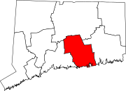
Middletown has remained an important government administrative center. From the creation of Middlesex County in 1798 until the elimination of county government in 1965 Middletown was the county seat. Middletown today retains Middlesex Superior Court, and the Judicial District remains that of the former county court. Other county functions were either centralized to the state or transferred to the towns. The former county building has been removed, but there are other state agency buildings elsewhere in the city, such as the Dept. of Social Services on Main Street Ext. Middletown's Probate Court district includes the towns of Cromwell, Portland, Middlefield and Haddam. The city is also the site of the controversial State Juvenile Training Center.
Arrigoni Building (former Arrigoni Hotel, now low-income housing) and others in Middletown's North End
Culturally and politically, Middletown is in the midst of an effort to revitalize its historically disadvantaged North End. Economic development projects recently completed in the North End include Wharfside Commons, a 96-unit mixed income apartment block, and the new Community Health Center (completed in 2012 at the corner of Main and Grand Streets[16]). The Green Street Arts Center, founded by Wesleyan and a coalition of community groups in 2000, is a pioneering attempt to attract residents and businesses to the neighborhood by promoting arts education and outreach. For decades, the famous O'Rourke's Diner has done much to bring some stability to the North End. A fire on August 31, 2006, gutted much of the historic structure. The Middletown community held many fundraising events to raise money for the diner's rebuilding. Reconstruction began in September 2007, and O'Rourke's Diner re-opened in February 2008. Mayor Daniel Drew (2011–2019) supported citizen-oriented efforts to revitalize the North End, such as the local nonprofit NEAT (North End Action Team). In 2012, the City of Middletown and NEAT partnered to form the "I Heart the North End" initiative, which plans to raise public awareness of the economic and cultural opportunities available in the area.
Oddfellows Playhouse
Middletown is the only location of a well-known youth theater group, Oddfellows Playhouse, which is located on Washington Street and pulls in children of all ages from all over the state to learn theater skills. Oddfellows also runs the Children's Circus of Middletown where children learn circus skills and put on a free show for close to a thousand people.
Middletown is also host to the Kidcity Children's Museum located in a renovated and recently expanded former home of Judge Elmer, which was moved 400 feet (120m) down Washington Street to its current location. Kidcity is a hands-on playspace where children ages 1 through 8 come with parents and other significant adults to learn through play. The Downtown Business District continues to revitalize the downtown area. Pratt and Whitney, Aetna, Middlesex Hospital, Connecticut Valley Hospital, Liberty Bank, and Wesleyan University are major employers. Located on the western border of the city, in an area known as Westlake, is an 84 house community known as The Farms. This architectural award-winning community was developed in 1969 by George Achenbach, and was one of the first communities in Connecticut designed for cluster living, with open areas designated as common land.
There are also many parks and nature trails including the Middletown Nature Gardens, Wadsworth Falls State Park and Smith Park, and 100 acres (0.40km2) of open property at the Guida Farm Conservation Area for families to enjoy. Harbor Park is a 2.6-acre (11,000m2) recreation area on the Connecticut River, featuring a boardwalk, restaurant/nightclub, fishing, seasonal boat excursions, and the Middletown High School and Wesleyan University crew boathouses. July 4 festivities, as well as the head of the Connecticut Regatta event in October are conducted from Harbor Park.
Middlesex Hospital[17] a major employer in Middletown and throughout Middlesex County, is spending $31 million to build a new emergency department. The new emergency department opened on March 24, 2008. Along with the new department, a helipad will be added along with 70 new parking spaces for patients.[citation needed]
The saltboxSamuel Harris House, built in 1686 and not listed on the National Register, may be the oldest surviving house in Middletown.[20][21]
Geography
Higby Mountain
Middletown sits on the west bank of the Connecticut River, in the south-central portion of the state. Running alongside the river, Route 9 bisects the city. According to the United States Census Bureau, the city has a total area of 42.3square miles (109.6km2), of which 40.9square miles (105.9km2) is land and 1.4square miles (3.7km2) is water. The total area is 3.36% water. Middletown shares borders with the neighboring towns of Cromwell, Portland, East Hampton, Haddam, Durham, Middlefield, Berlin, and Meriden. Of all the neighboring towns, Portland and East Hampton are the only ones that do not have any land boundaries, as they are located on the eastern side of the Connecticut River.
Highland – The westernmost neighborhood of Middletown. It is the only section of the city that Interstate 91 passes through within its total distance through Middletown.
Westfield – Formerly a village, now a mostly residential neighborhood located in the northwestern corner of the city, lying just south of the border with Cromwell.
Miramichi – A mostly residential neighborhood located in the southwest corner of the city, lying just north of the border with Middlefield.
Newfield Heights – A commercial-neighborhood with many businesses and restaurants located just to the north of the city center.
Bretton Heights – A mostly residential neighborhood located a few miles west from the city center.
Lakeridge Heights – A semi-industrial neighborhood located just below the South Farms area, and just above the Durham town-line.
South Farms – A mostly residential area lying just to the south of the city center.
Maromas – A largely industrial and mostly-uninhabited neighborhood, located in the southeastern part of the city. Pratt & Whitney has one of its offices located in this area.
As of the census[23] of 2020, there were 47,717 people, and 20,089 households residing in the city, with an average household size of 2.14. The population density was 1,163.26 inhabitants per square mile (449.14/km2). There were 21,549 housing units at an average density of 508.59 per square mile (196.37/km2) and a vacancy rate of 7%. Owner occupied housing made up 54% of the units and the average value of owner occupied housing units was $240,700.
The racial makeup of the city was 66.2% White only, not Hispanic or Latino, 15.7% Black or African American, 10.9% Hispanic or Latino, and 5.7% Asian. The foreign born population made up 11.9% of residents.
15.5% of residents were under the age of 18, and 16.2% were 65 years of age or older. The median age was 39.5 years.
The median income for a household in the city was $62,022. Males had a median income of $49,846 versus $37,412 for females. The per capita income for the city was $39,845. 12.3% of the population below the poverty line.
The city has one Roman Catholic elementary school, Saint John Paul II Regional Catholic School,[31] and two Roman Catholic high schools, Xavier High School for boys and Mercy High School for girls.
Middletown also has one technical high school, Vinal Technical High School.[32]
Russell Library is the public library of Middletown. It has books, newspapers, magazines, informational databases of full-text newspaper and magazine articles, classes, computer training, workshops, concerts, and meeting spaces.
Media
Middletown has three regular news outlets. The Middletown Press is a daily broadsheet which covers news in the Middletown area. The Hartford Courant is a daily broadsheet which includes a Middletown story in every issue. Three radio stations are licensed to Middletown: WMRD 1150 AM (variety), WESU 88.1 FM (Wesleyan University) and WIHS 104.9 FM (religious).
Transportation
River Valley Transit provides public transportation services throughout Middletown as well as service between Middletown and Old Saybrook, which, along with New Haven, provides connections to Amtrak intercity trains and Shore Line Eastcommuter rail service. The New Britain Transportation Company provides connecting service to New Britain and the surrounding area; and Connecticut Transit provides local and express service to Hartford as well as express service to New Haven.
This notable people list is divided into three sections: people born in Middletown, people who currently live in Middletown, and people who once lived in Middletown at some point in their lives.
The following notable people were born in Middletown:
1 2 Warner, Elizabeth. A Pictorial History of Middletown. Greater Middletown Preservation Trust. Donning Publishers. Norfolk, Virginia, 1990.
1 2 3 4 Middlesex County Historical Society and Wesleyan University Library's Special Collections Archives. The History of Middletown "Part I: 1650–1800." Prepared by Jeff Harmon. Cited from the City of Middletown websiteArchived May 15, 2006, at archive.today January 1, 2007.
↑ Cronin, William. Changes in the Land: Indians, Colonists, and the Ecology of New England. 2003, Hill and Wang, New York.
↑ Secretary of the Vermont Senate. "Biography, Senator Mark A. MacDonald". Vermont State Senate. Montpelier, VT: Vermont General Assembly. Retrieved February 21, 2017.
↑ Connecticut Town Birth records, entry for Samuel Mattocks, 1854, page 14
↑ Vermont Secretary of State, Legislative Directory, 1981, page 105
History of Middlesex County 1635–1885: With Biographical Sketches of Its Prominent Men. Pratt & Read Co. New York: J. B. Beers & Co., 1884.
History of Middlesex County, Connecticut, Whittemore, (New York, 1884)
Middletown Upper Houses: A History of the North Society of Middletown from 1650 to 1800, C.C. Adams, (New York, 1908)
Further reading
Dyson, Stephen L. "Material culture, social structure, and changing cultural values: the ceramics of eighteenth-and nineteenth-century Middletown, Connecticut." in Archaeology of Urban America (Academic Press, 1982) pp. 361–380.
Hall, Peter Dobkin. Middletown--streets, commerce, and people, 1650–1981 (Sesquicentennial papers, 1981)
Schatz, Ronald W. "The Barons of Middletown and the Decline of the North-Eastern Anglo-Protestant Elite." Past & Present, no. 219, (2013), pp. 165–200. JSTOR24543604. WASP loss of control of Middletown in late 1930s.
Core cities are metropolitan core cities of at least a million people. The other areas are urban areas of cities that have an urban area of 150,000+ or of a metropolitan area of at least 250,000+. Satellite cities are in italics.
This page is based on this Wikipedia article Text is available under the CC BY-SA 4.0 license; additional terms may apply. Images, videos and audio are available under their respective licenses.