Ball Mountain Dam

Last updated
Ball Mountain Dam
USACE Ball Mountain Lake and Dam.jpg
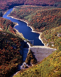
Ball Mountain Dam and Reservoir
CountryUnited States
Coordinates 43°7′40.66″N72°46′25.97″W / 43.1279611°N 72.7738806°W / 43.1279611; -72.7738806 Coordinates: 43°7′40.66″N72°46′25.97″W / 43.1279611°N 72.7738806°W / 43.1279611; -72.7738806

Ball Mountain Dam (National ID # VT00001) is a dam in Jamaica, Windham County, Vermont, in the southeastern part of the state.

The earthen and gravel gravity dam was constructed between 1957 and 1961 by the United States Army Corps of Engineers, with a height of 247 feet (75 m) and a length of 915 feet (279 m) at its crest. [1] It impounds the West River of Vermont for flood control. The dam is owned and operated by the Army Corps of Engineers. The Corps identified safety and seepage problems with the dam in 2009, [2] and has assigned it a Dam Safety Action Class rating of DSAC II, or "Urgent". [3]

The reservoir it creates, Ball Mountain Reservoir, has a normal water surface of 20 acres (8.1 ha), a maximum capacity of 52,450 acre-feet (65 million cubic meters ), and a normal capacity of 240 acre⋅ft (300 thousand m3). [4] Recreation includes fishing (for stocked Atlantic salmon, smallmouth bass, and trout), camping at 111 campsites in nearby Winhall and Jamaica, and activities at the adjacent Jamaica State Park. The river between Ball Mountain Lake and downstream Townshend Lake (also operated by the Army Corps of Engineers) is used for white water boating during releases from the Ball Mountain Dam, usually occurring during one weekend in April and one weekend in September. [5] [6]

Related Research Articles

Lake Isabella Body of water

Lake Isabella also called Isabella Lake, is a reservoir in Kern County, California, United States created by the earthen Isabella Dam. It was formed in 1953 when the U.S. Army Corps of Engineers dammed the Kern River at the junction of its two forks. At 11,000 acres (4,500 ha), it is one of the larger reservoirs in California. The area is in the southern end of the Sierra Nevada range and the lake itself is located in low mountains at an elevation of approximately 2,500 ft (760 m) where summer temperatures reach over 100 °F (38 °C) but low enough to avoid winter snows on the surrounding ridges. Lake Isabella is located about 40 miles (64 km) northeast of Bakersfield, and is the main water supply for that city. Lake Isabella can be reached by car from Bakersfield via state Highway 178 and from Delano via Highway 155. The former towns of Isabella and Kernville were flooded by the newly created reservoir.

Table Rock Lake Man-made lake in Missouri and Arkansas, United States

Table Rock Lake is an artificial lake or reservoir in the Ozarks of southwestern Missouri and northwestern Arkansas in the United States. Designed, built and operated by the U.S. Army Corps of Engineers, the lake is impounded by Table Rock Dam, which was constructed from 1954 to 1958 on the White River.

Yatesville Lake Body of water

Yatesville Lake is a reservoir in Lawrence County, Kentucky in the far eastern part of the state, close to the town of Louisa.

Wilson Lake (Kansas) Body of water

Wilson Lake is a reservoir in the U.S. state of Kansas, on the border of Russell County and Lincoln County. Built and managed by the U.S. Army Corps of Engineers for flood control, it is also used for wildlife management and recreation. Several parks are located along its shoreline, including Wilson State Park.

Isabella Dam is an embankment dam located in the Kern River Valley, about halfway down the Kern River course, between the towns of Kernville and Lake Isabella in Kern County, California.

West River (Vermont)

The West River is a tributary of the Connecticut River, about 53.8 miles (86.6 km) long, in southern Vermont in the United States. According to the Geographic Names Information System, it has also been known historically as "Wantastiquet" and as "Waters of the Lonely Way". Its watershed covers 423 square miles (1,100 km2); land use is about 90% forested and 3% agricultural, and the upper river supports wild native brook and wild brown trout, while Atlantic salmon occur in most of the river.

Surry Mountain Lake Body of water

Surry Mountain Lake is a 353-acre (1.43 km2) impoundment on the Ashuelot River in Cheshire County in southwestern New Hampshire, United States, in the town of Surry.

Perry Lake (Kansas) Body of water

Perry Lake is a US Army Corps of Engineers operated reservoir in northeast Kansas. Its primary purposes are flood control, water reserve for nearby areas and regional recreation. The lake is approximately 11,150 acres (45 km²) in size, with over 160 miles (260 km) of shoreline. Perry Lake's full multi-purpose pool elevation is 891.5 feet (271.7 m) above sea level. Perry Lake is located about 40 miles (64 km) west of Kansas City, just northwest of Lawrence, Kansas. Its close proximity to Kansas City, Lawrence, and the state capitol, Topeka, make it a very popular destination, with the nickname "Paradise on the Plains".

Folsom Dam Dam in Folsom, California

Folsom Dam is a concrete gravity dam on the American River of Northern California in the United States, about 25 mi (40 km) northeast of Sacramento. The dam is 340 ft (100 m) high and 1,400 ft (430 m) long, flanked by earthen wing dams. It was completed in 1955, and officially opened the following year.

Shenango River Lake Body of water

Shenango River Lake is a reservoir in the Shenango River Valley of western Pennsylvania and northeastern Ohio. Authorized by the Flood Control Acts of 1938, the lake is one of 16 flood control projects in the Pittsburgh District designed to prevent flooding. It is a popular site among anglers and is lined by 330 campsites.

John Redmond Reservoir Body of water

John Redmond Reservoir is a reservoir on the Neosho River in eastern Kansas. Built and managed by the U.S. Army Corps of Engineers, it is used for flood control, recreation, water supply, and wildlife management. It borders the Flint Hills National Wildlife Refuge to the northwest.

Bowman-Haley Dam Dam in Bowman County, North Dakota

Bowman-Haley Dam is an embankment dam located in Bowman County, North Dakota, in the southwestern part of the state. The dam is just over 2 miles north of the South Dakota border.

Council Grove Lake Body of water

Council Grove Lake is a reservoir on the Neosho River in east-central Kansas. Built and managed by the U.S. Army Corps of Engineers, it is used for flood control, recreation, and water supply.

Copan Dam

Copan Dam is a dam in Washington County, Oklahoma, in the northeastern part of the state.

Abiquiu Dam Dam in Rio Arriba County, New Mexico

Abiquiu Dam is a dam on the Rio Chama, located about 60 miles (97 km) northwest of Santa Fe in Rio Arriba County, New Mexico. Built and operated by the U.S. Army Corps of Engineers (USACE), the dam is an earth embankment structure 354 feet (108 m) high and 1,800 feet (550 m) long, containing 11.8 million cubic yards of fill. The dam forms Abiquiu Lake, one of the largest lakes in New Mexico with a full storage capacity of 1,369,000 acre-feet (1,689,000 dam3) and 5,200 acres (2,100 ha) of water. To date, the reservoir has never filled to capacity, with a record high of 402,258 acre-feet (496,178 dam3), 29.4% of full pool, on June 22, 1987. The dam's primary purpose is flood control, in addition to irrigation and municipal water storage, and hydroelectric generation.

Townshend Dam Dam

Townshend Dam is a dam in Townshend, Windham County, Vermont.

Brookville Lake Dam Dam in Franklin County, Indiana

Brookville Lake Dam is a dam in Brookville Township, Franklin County, Indiana, just north of Brookville, in the southeastern part of the state.

North Hartland Dam Dam

North Hartland Dam is a dam on the Ottauquechee River in Hartland, Windsor County, Vermont.

Moore Dam Dam on the border of New Hampshire and Vermont

Moore Dam is a major hydroelectric dam on the Upper Connecticut River between Grafton County, New Hampshire and Caledonia County, Vermont in the northeastern United States. The dam is located near Littleton, New Hampshire, and forms the 3,490-acre (1,410 ha) Moore Reservoir. The Moore Station is the largest conventional hydroelectric plant in New England, in terms of installed capacity and average power generation. The dam and reservoir also provide flood control, recreational boating and fishing.

References

  1. "Archived copy". Archived from the original on 2015-05-18. Retrieved 2012-09-01.{{cite web}}: CS1 maint: archived copy as title (link)
  2. "Army Corps of Engineers - New England District - Ball Mountain Dam (VT) - Dam Safety Modification Project". Archived from the original on 2013-02-21. Retrieved 2012-09-01.
  3. "Documents" (PDF). www.nad.usace.army.mil. Archived from the original (PDF) on 2014-01-25. Retrieved 2015-05-15.
  4. "Ball Mountain Lake". findlakes.com.
  5. "West River Whitewater Rafting - Whitewater Rafting Vermont - Family Whitewater Rafting VT - Zoar Outdoor". www.zoaroutdoor.com.
  6. "Rafting America West River info". raftingamerica.com. Archived from the original on 2012-02-04. Retrieved 2012-09-01.