[http://geonames.usgs.gov/pls/gnispublic/f?p=gnispq:3:::NO::P3_FID:608414 Dead Branch (East Branch)]"},"tributaries_right":{"wt":"[http://geonames.usgs.gov/pls/gnispublic/f?p=gnispq:3:::NO::P3_FID:608613 Middle Branch]
[http://geonames.usgs.gov/pls/gnispublic/f?p=gnispq:3:::NO::P3_FID:608520 West Branch]
[http://geonames.usgs.gov/pls/gnispublic/f?p=gnispq:3:::NO::P3_FID:608892 Little River]"},"custom_label":{"wt":""},"custom_data":{"wt":""},"extra":{"wt":"{{Designation list\n| embed = yes\n| designation1 = nwsr\n| designation1_type = Wild,Scenic,Recreational\n| designation1_date = November 2,1993\n| designation1_number =\n}}"}},"i":0}}]}" id="mwBA">.mw-parser-output .infobox-subbox{padding:0;border:none;margin:-3px;width:auto;min-width:100%;font-size:100%;clear:none;float:none;background-color:transparent}.mw-parser-output .infobox-3cols-child{margin:auto}.mw-parser-output .infobox .navbar{font-size:100%}body.skin-minerva .mw-parser-output .infobox-header,body.skin-minerva .mw-parser-output .infobox-subheader,body.skin-minerva .mw-parser-output .infobox-above,body.skin-minerva .mw-parser-output .infobox-title,body.skin-minerva .mw-parser-output .infobox-image,body.skin-minerva .mw-parser-output .infobox-full-data,body.skin-minerva .mw-parser-output .infobox-below{text-align:center}@media screen{html.skin-theme-clientpref-night .mw-parser-output .infobox-full-data:not(.notheme)>div:not(.notheme)[style]{background:#1f1f23!important;color:#f8f9fa}}@media screen and (prefers-color-scheme:dark){html.skin-theme-clientpref-os .mw-parser-output .infobox-full-data:not(.notheme) div:not(.notheme){background:#1f1f23!important;color:#f8f9fa}}@media(min-width:640px){body.skin--responsive .mw-parser-output .infobox-table{display:table!important}body.skin--responsive .mw-parser-output .infobox-table>caption{display:table-caption!important}body.skin--responsive .mw-parser-output .infobox-table>tbody{display:table-row-group}body.skin--responsive .mw-parser-output .infobox-table tr{display:table-row!important}body.skin--responsive .mw-parser-output .infobox-table th,body.skin--responsive .mw-parser-output .infobox-table td{padding-left:inherit;padding-right:inherit}}
Westfield River Agawam River (archaic) | |
---|---|
![]() Westfield River in Huntington (the "Main Stem") | |
![]() The Westfield River and its major tributaries | |
Location | |
Country | United States |
State | Massachusetts |
Region | Metropolitan Springfield |
District | Hampden County, Massachusetts |
Municipality | Westfield, Massachusetts |
Physical characteristics | |
Source | North Branch Westfield River |
• location | Berkshires |
• coordinates | 42°34′09″N73°01′54″W / 42.56917°N 73.03167°W |
• elevation | 1,734 ft (529 m) |
Source confluence | debouch of the Swift River |
• coordinates | 42°26′39″N72°51′31″W / 42.44417°N 72.85861°W |
• elevation | 922 ft (281 m) |
Mouth | Connecticut River |
• coordinates | 42°05′03″N72°35′08″W / 42.08417°N 72.58556°W |
• elevation | 39 ft (12 m) |
Length | 78.1 mi (125.7 km) |
Basin size | 517 sq mi (1,340 km2) |
Basin features | |
Tributaries | |
• left | Swift River Dead Branch (East Branch) |
• right | Middle Branch West Branch Little River |
Type | Wild, Scenic, Recreational |
Designated | November 2, 1993 |
The Westfield River is a major tributary of the Connecticut River located in the Berkshires and Pioneer Valley regions of western Massachusetts. With four major tributary branches that converge west of the city of Westfield, it flows 78.1 miles (125.7 km) (measured from the source of its North Branch) before its confluence with the Connecticut River at Agawam, across from the city of Springfield's Metro Center district. [1] [2] Known for its whitewater rapids and scenery, the Westfield River provides over 50 miles (80 km) of whitewater canoeing and kayaking, in addition to one of the largest roadless wilderness areas remaining in the Commonwealth. [3]
The Westfield River is the Connecticut River's longest tributary in Massachusetts, although the Chicopee River's basin is much larger, and contributes more water to the Connecticut. The Connecticut's northern tributary, the Deerfield River, is nearly as long as the Westfield, being only 2.1 miles (3.4 km) shorter.
During the mid-20th century, the Westfield River was so polluted that it would change color based on the nature of the contaminant. Today, the river is clean enough for swimming. [4] It is a state and locally managed river featuring native trout fishing and rugged mountain scenery in the context of a historical mill town settlement (at Westfield).
On its initial discovery by Massachusetts Bay Colony explorers John Cable and John Woodcock in 1635, the area stretching from the Westfield River's confluence with the Connecticut River to Westfield itself—which, the next year, would all be encompassed in the settlement that came to be known as Springfield—was named the "Agawam River", after the name of the Native American people then occupying the area. Historical literature often refers to Springfield as sitting at the confluence of the Connecticut River with the western Agawam River and eastern Chicopee River. This "Agawam River" is now known as the Westfield River, and should not be confused with the Agawam River in southeastern Massachusetts, which was named in tribute to Springfield's tribe of Native Americans.
The Westfield River runs for a total of 78.1 miles (125.7 km). Rising in the Berkshire Hills region of Massachusetts, it flows southeastwardly to join the Connecticut River at Agawam—directly across from Springfield's Metro Center (downtown). [1]
The Westfield River has a 497-square-mile (1,290 km2) drainage area that includes three named branches, which join in Huntington to form the Westfield River's main stem, which flows through Russell into Westfield. The branches are the North Branch (sometimes called the East Branch), which rises in the town of Savoy and flows southeast through Windsor, Cummington, and Chesterfield; the Middle Branch, which rises in the town of Peru and flows southeast through Worthington, Middlefield, and Chester; and the West Branch, which has its origins in Washington and Becket, then flows east through Chester.
The three branches converge in the town of Huntington: the Middle and North Branch (or "East Branch") merge near the village of Goss Heights, 2 miles (3 km) north of their junction with the West Branch (designated a National Wild and Scenic river) at Huntington village. From Huntington, the main stem of the Westfield River flows through Russell and Westfield, then forms the boundary between West Springfield and Agawam before ending at the Connecticut River.
Every April, the Westfield River in Huntington is the home of the Westfield River Whitewater Races, the oldest continuously run whitewater race in the United States.[ citation needed ]
Portions of the river's watershed have been designated the Westfield Creek Wild and Scenic River, and form part of the National Wild and Scenic Rivers System.
From the mouth heading upstream, the first dam is the West Springfield Dam, which creates a reservoir north of Robinson State Park. This powers two hydropower turbines owned by A & D Hydro, rated at 900 and 466 kW. [5] The 18-foot-high stone and concrete dam includes a 50-foot-wide power canal, and was constructed in 1836. [6]
The second dam (actually two dams, north and south, with an island in the middle) is in the village of Woronoco in the town of Russell. Woronoco hydro station, owned by Eagle Creek Renewable Energy, is at Salmon Falls, also known as Woronoco Falls. It has three Francis turbines, rated for a total of 2.7 MW. [7] These falls were first dammed in the 1870s by the Woronoco Paper Company, later merged with the Strathmore Paper Company. The current dams were constructed in 1938 and 1950 by Strathmore; the paper mills operated until 1999. [7] [8]
The third dam is at the Indian River Power Supply plant on Station Road in Russell. The modern hydroelectric plant is also owned by Eagle Creek Renewable Energy, and is rated at 1.4 MW, with two Francis turbines. The dam and plant were originally constructed by the Westfield River Paper Company in 1909. [7]
The fourth dam is Crescent Dam, located in the Crescent Mills neighborhood of Russell at mile 24 of the river. This site was formerly a Chapin and Gould Paper Company mill (later known as Texon). [9] The Texon Hydroelectric Project at the site is rated at 1.5 MW, and is owned by Gravity Renewables. [10]
The fifth dam is the Knightville Dam in Huntington, Massachusetts. After the 1936 flood on the Westfield and Connecticut Rivers, it was constructed by the Army Corps of Engineers from August 1939 to December 1941 for $3.3 million. [11] It is only used for flood control and does not normally impound a reservoir. [11] Construction required relocation of Route 112 [11] and a cemetery. Thirty-three homes were demolished, two were moved, and a gas station and store were obliterated. [12] The dam is credited with averting hundreds of millions of dollars in downstream flood damages. [11]
Hampden County is a non-governmental county located in the Pioneer Valley of the U.S. state of Massachusetts, in the United States. As of the 2020 census, Hampden County's population was 465,825. Its traditional county seat is Springfield, the Connecticut River Valley's largest city, and economic and cultural capital; with an estimated population of 154,758, approximately one-third of Hampden County residents live in Springfield.
Russell is a town in Hampden County, Massachusetts, United States. The population was 1,643 at the 2020 census. It is part of the Springfield, Massachusetts Metropolitan Statistical Area.
Westfield is a city in Hampden County, in the Pioneer Valley of western Massachusetts, United States. Westfield was first settled by Europeans in 1660. It is part of the Springfield, Massachusetts Metropolitan Statistical Area. The population was 40,834 at the 2020 census.
The Pioneer Valley is the colloquial and promotional name for the portion of the Connecticut River Valley that is in Massachusetts in the United States. It is generally taken to comprise the three counties of Hampden, Hampshire, and Franklin. The lower Pioneer Valley corresponds to the Springfield, Massachusetts metropolitan area, the region's urban center, and the seat of Hampden County. The upper Pioneer Valley region includes the smaller cities of Northampton and Greenfield, the county seats of Hampshire and Franklin counties, respectively.
The Connecticut River is the longest river in the New England region of the United States, flowing roughly southward for 406 miles (653 km) through four states. It rises 300 yards south of the U.S. border with Quebec, Canada, and discharges at Long Island Sound. Its watershed encompasses 11,260 square miles (29,200 km2), covering parts of five U.S. states and one Canadian province, via 148 tributaries, 38 of which are major rivers. It produces 70% of Long Island Sound's fresh water, discharging at 18,400 cubic feet (520 m3) per second.
West Springfield is a city in Hampden County, Massachusetts, United States. It is part of the Springfield, Massachusetts Metropolitan Statistical Area. The population was 28,835 at the 2020 United States Census. The city is also known as "West Side", in reference to the fact that it is on the western side of the Connecticut River from Springfield, a fact which played a major part in the town's early history.
The Housatonic River is a river, approximately 149 miles (240 km) long, in western Massachusetts and western Connecticut in the United States. It flows south to southeast, and drains about 1,950 square miles (5,100 km2) of southwestern Connecticut into Long Island Sound.
Western Massachusetts, known colloquially as "western Mass," is a region in Massachusetts, one of the six U.S. states that make up the New England region of the United States. Western Massachusetts has diverse topography; 22 colleges and universities including UMass in Amherst, MA, with approximately 100,000 students; and such institutions as Tanglewood, the Springfield Armory, and Jacob's Pillow.
The Farmington River is a river, 46.7 miles (75.2 km) in length along its main stem, located in northwest Connecticut with major tributaries extending into southwest Massachusetts. The longest route of the river, from the origin of its West Branch, is 80.4 miles (129.4 km) long, making it the Connecticut River's longest tributary by 2.3 miles (3.7 km) over the Westfield River directly to its north. The Farmington River's watershed covers 609 square miles (1,580 km2). Historically, the river played an important role in small-scale manufacturing in towns along its course, but it is now mainly used for recreation and drinking water.
Deerfield River is a river that runs for 76 miles (122 km) from southern Vermont through northwestern Massachusetts to the Connecticut River. The Deerfield River was historically influential in the settlement of western Franklin County, Massachusetts, and its namesake town. It is the Connecticut River's second-longest tributary in Massachusetts, 2.1 miles (3.4 km) shorter than Metropolitan Springfield's Westfield River.
The Pemigewasset River, known locally as "The Pemi", is a river in the state of New Hampshire, the United States. It is 65.0 miles (104.6 km) in length and drains approximately 1,021 square miles (2,644 km2). The name "Pemigewasset" comes from the Abenaki word bemijijoasek [bəmidzidzoasək], meaning "where side (entering) current is".
The Winooski River is a tributary of Lake Champlain, approximately 90 miles (145 km) long, in the northern half of Vermont. Although not Vermont's longest river, it is one of the state's most significant, forming a major valley way from Lake Champlain through the Green Mountains towards the Connecticut River valley.
The Ware River is a 35.4-mile-long (57.0 km) river in central Massachusetts. It has two forks, its West Branch, which begins in Hubbardston, Massachusetts, and its East Branch, which begins in Westminster, Massachusetts. The Ware River flows southwest through the middle of the state, joins the Quaboag River at Three Rivers, Massachusetts, to form the Chicopee River on its way to the Connecticut River.
The North Branch of the Westfield River starts at the town of Savoy, Massachusetts, in the Berkshires. It flows southeasterly to the town of Cummington where it follows Route 9 to the junction with the Swift River. Here it turns sharply south and flows through the picturesque Pork Barrel region to West Chesterfield. It continues through a wilderness region to the Knightville Reservoir. From here it continues south for about 5 miles to Huntington, Massachusetts, where it becomes the main branch of the Westfield River. The Middle Branch and the West Branch join it in this section.
The Quinebaug River is a river in south-central Massachusetts and eastern Connecticut, with watershed extending into western Rhode Island. The name "Quinebaug" comes from the southern New England Native American term, spelled variously Qunnubbâgge, Quinibauge, etc., meaning "long pond", from qunni-, "long", and -paug, "pond". The river is one of the namesake rivers in the Quinebaug and Shetucket Rivers Valley National Heritage Corridor.
The Black River is a 40.8-mile-long (65.7 km) river in the U.S. state of Vermont, and a tributary of the Connecticut River. The river's watershed consists of approximately 202 square miles (520 km2) in southeastern Vermont, almost all of which lies in Windsor County.
The Chicopee River is an 18.0-mile-long (29.0 km) tributary of the Connecticut River in the Pioneer Valley, Massachusetts, known for fast-moving water and its extraordinarily large basin: the Connecticut River's largest tributary basin. The Chicopee River originates in a Palmer, Massachusetts village called Three Rivers as a confluence of the Ware, Quaboag and Swift rivers. It passes through Wilbraham, Ludlow, and the Indian Orchard neighborhood of Springfield.
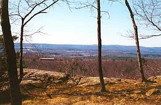
Provin Mountain is a very narrow traprock mountain ridge located in the Connecticut River Valley of Massachusetts. It is part of the Metacomet Ridge which extends from Long Island Sound near New Haven, Connecticut, north through the Connecticut River Valley of Massachusetts to the Vermont border. Provin Mountain is known for its scenic cliffs, unique microclimate ecosystems, and rare plant communities. It is traversed by the 114 mile (183 km) Metacomet-Monadnock Trail.
The Mill River is a 1.25-mile-long (2.01 km) tributary of the Connecticut River in Springfield, Massachusetts. It flows from Watershops Pond to its confluence with the Connecticut River. It is referred to as "The Miracle Mile" in a 2009 master's thesis that outlines possibilities for reclaiming the river's mouth as a recreational area. As of 2011, the final 350 feet (110 m) of the river, including its mouth, is confined in a pipe underneath Interstate 91, railroad tracks and a car dealership. Many Springfield residents have bemoaned the loss of the Mill River as a recreational area, and hope to gain greater access to both it and the Connecticut River in upcoming years. As it has for over a century, today the Mill River serves as a barrier between Springfield neighborhoods. Surrounding it are some of the most densely urbanized locations in Springfield.