
The Mystic River is a 7.0-mile-long (11.3 km) river in Massachusetts. In the Massachusett language, missi-tuk means "large estuary", alluding to the tidal nature of the Mystic River. The resemblance to the English word mystic is a coincidence, which the colonists followed.

The Department of Conservation and Recreation (DCR) is a state agency of the Commonwealth of Massachusetts, United States, situated in the Executive Office of Energy and Environmental Affairs. It is best known for its parks and parkways. The DCR's mission is "To protect, promote and enhance our common wealth of natural, cultural and recreational resources for the well-being of all." The agency is the largest landowner in Massachusetts.

Middlesex Fells Reservation, often referred to simply as the Fells, is a public recreation area covering more than 2,200 acres (890 ha) in Malden, Medford, Melrose, Stoneham, and Winchester, Massachusetts, United States. The state park surrounds two inactive reservoirs, Spot Pond and the Fells Reservoir, and the three active reservoirs that are part of the water supply system for the town of Winchester. Spot Pond and the Fells Reservoir are part of the Wachusett water system, one of six primary water systems that feed metropolitan Boston's waterworks. The park is managed by the Massachusetts Department of Conservation and Recreation and is part of the Metropolitan Park System of Greater Boston.

Alewife Brook Reservation is a Massachusetts state park and urban wild located in Cambridge, Arlington, and Somerville. The park is managed by the state Department of Conservation and Recreation and was established in 1900. It is named for Alewife Brook, which was also historically known as Menotomy River, a tributary of the Mystic River.

The National Register of Historic Places is a United States federal official list of places and sites considered worthy of preservation. In the state of Massachusetts, there are over 4,300 listings, representing about 5% of all NRHP listings nationwide and the second-most of any U.S. state, behind only New York. Listings appear in all 14 Massachusetts counties.

Memorial Drive, colloquially referred to as Mem Drive, is a 3.9-mile (6.3 km) parkway along the north bank of the Charles River in Cambridge, Massachusetts, United States.

Alewife Brook Parkway is a short parkway in Cambridge and Somerville, Massachusetts. It is listed on the National Register of Historic Places. It begins at Fresh Pond in Cambridge, and heads north on the east bank of Alewife Brook, crossing into West Somerville and ending at the Mystic River on the Medford town line, where it becomes Mystic Valley Parkway. The entire length of Alewife Brook Parkway is designated as part of Massachusetts Route 16 (Route 16), while the southernmost sections are also designated as part of Route 2 and U.S. Route 3 (US 3). It is managed by the Department of Conservation and Recreation with the Massachusetts Department of Transportation responsible for bridge maintenance.
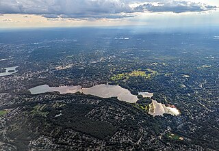
The Mystic Lakes, consisting of Upper Mystic Lake and Lower Mystic Lake, are closely linked bodies of water in the northwestern suburbs of Boston, Massachusetts.

Mystic Valley Parkway is a parkway in Arlington, Medford, Somerville, and Winchester, Massachusetts, United States. It is listed on the National Register of Historic Places, and forms part of Route 16.

The Charles River Bike Path is a mixed-use path in the Boston, Massachusetts area. A portion of the trail is named after the cardiologist Paul Dudley White, a prominent advocate of preventive medicine. His research led him to proclaim frequently "I'd like to put everybody on bicycles." In 1955 White served as president Eisenhower's cardiologist and prescribed his famous patient bicycle therapy after his 1955 heart attack.

The Fells Connector Parkways are a group of historic parkways in the cities of Malden and Medford, Massachusetts, suburbs north of the city of Boston. The three parkways, The Fellsway, Fellsway West, and Fellsway East serve to provide access from the lower portion of the Mystic River Reservation to the Middlesex Fells Reservation. The latter two parkways continue northward, providing access to the interior of the Fells and providing a further connection to Lynn Fells Parkway. Significant portions of these parkways south of the Fells, which were among the first connecting parkways designed to be part of the Metropolitan Park System of Greater Boston by Charles Eliot, were listed on the National Register of Historic Places in 2003.

The Charles River Reservation Parkways are parkways that run along either side of the Charles River in eastern Massachusetts. The roads are contained within the Charles River Reservation and the Upper Charles River Reservation, and fall within a number of communities in the greater Boston metropolitan area. The Charles River parks extend from the Charles River Dam, where the Charles empties into Boston Harbor, to Riverdale Park in the West Roxbury neighborhood of Boston. Most of the roadways within the parks are listed on the National Register of Historic Places as a unit, although Storrow Drive and Memorial Drive are listed as part of the Charles River Basin Historic District.

The Middlesex Fells Reservation Parkways are the roadways within and bordering on the Middlesex Fells Reservation, a state park in the northern suburbs of Boston, Massachusetts, United States. The park includes portions of the towns of Malden, Medford, Melrose, Stoneham, and Winchester. The roads inside the park and around its perimeter have been listed on the National Register of Historic Places. Other portions of some of the roads are covered by more than one listing in the national register; see Fellsway Connector Parkways and Middlesex Fells Reservoirs Historic District.
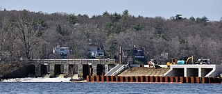
The Mystic Dam are a historic dam and gatehouse between Lower and Upper Mystic Lakes in the suburbs north of Boston, Massachusetts. The dam was built in 1864–65 by the Charlestown Water Commission as part of a water supply system. It was located at a narrow point between the Lower and Upper Mystic Lakes, with its west end in Arlington and its east end in Medford. The water system it was a part of eventually merged into the Metropolitan District Commission (MDC), predecessor to the Massachusetts Water Resources Authority (MWRA) and the Massachusetts Department of Conservation and Recreation (DCR).

The Middlesex Fells Reservoirs Historic District is a historic district roughly bounded by Pond St., Woodland Rd., I-93, and MA 28 in Stoneham and Medford, Massachusetts. It encompasses a portion of the Middlesex Fells Reservation, a state park managed by the Massachusetts Department of Conservation and Recreation (DCR). The principal features of the district are three reservoirs and their associated gate houses and pumping stations, which were developed by the Metropolitan District Commission starting in the late 19th century. The district was listed on the National Register of Historic Places in 1990.

Ten Hills is a neighborhood in the northeastern part of the city of Somerville, Massachusetts. The area is roughly wedge-shaped, about 50 acres (200,000 m2) in size, and is bounded by the Mystic River to the north, McGrath Highway to the east, and is largely separated from the rest of Somerville by Interstate 93 to the southwest. Ten Hills is next to Assembly Square in the east, and Winter Hill in the southwest. The neighborhood landscape is predominated by a single hill, the peak of which is roughly at the intersection of Temple and Putnam Roads. The Ten Hills neighborhood is located in Ward 4, Precinct 1 of the City of Somerville, which is in the 34th district of Middlesex County.

The Watertown Branch Railroad was a branch loop of the Fitchburg Railroad that was meant to serve the town of Watertown and the City of Waltham, Middlesex County, Massachusetts, as an independent short line railroad; it also serviced the Watertown Arsenal. The line has been formally abandoned and portions have been converted into a rail trail, the Watertown-Cambridge Greenway. A section from School Street to Arlington Street in Watertown was completed first. A small portion in Waltham has been converted into a park called Chemistry Station Park after the railroad station once located there. Construction of an extension to Fresh Pond Reservation in Cambridge began in the summer of 2018 and was completed in June 2022.

The Metropolitan Park System of Greater Boston is a system of reservations, parks, parkways and roads under the control of the Massachusetts Department of Conservation and Recreation (DCR) in and around Boston that has been in existence for over a century. The title is used by the DCR to describe the areas collectively: "As a whole, the Metropolitan Park System is currently eligible for listing on the National Register of Historic Places", as outlined on the department's website. The DCR maintains a separate Urban Parks and Recreation division to oversee the system, one of five such divisions within the department—DCR's Bureau of State Parks and Recreation manages the remainder of Massachusetts state parks. Direct design and maintenance functions for the parkways and roads within the system are provided by the DCR Bureau of Engineering.

Wilson Mountain Reservation is a state-owned, public recreation area and protected woodland park in Dedham, Massachusetts, managed by the Massachusetts Department of Conservation and Recreation. It features hiking trails, open space and a summit view of the Boston skyline, and is an important wildlife preserve. At 215 acres (87 ha), it is the largest remaining open space in Dedham. The reservation is part of the Metropolitan Park System of Greater Boston.
Route 16 is a 59.8646-mile-long (96.3427 km) east–west state highway in Massachusetts. It begins in the west at an intersection with Route 12 and Route 193 in Webster, just north of the Connecticut state border. It runs in a generally southwest-northeast routing through a number of Boston's suburbs and runs to the west and then north of the city before ending in Revere at an intersection with Route 1A and Route 60.


