Revere is a city in Suffolk County, Massachusetts, United States, located approximately 5 miles (8.0 km) from downtown Boston. Founded as North Chelsea in 1846, it was renamed in 1871 after the American Revolutionary War patriot Paul Revere. In 1914, the Town of Revere was incorporated as a city. As of the 2020 United States Census, the city has a population of 62,186 inhabitants.

Winthrop is a town in Suffolk County, Massachusetts, United States. The population was 19,316 at the 2020 census. Winthrop is an ocean-side suburban community in Greater Boston situated at the north entrance to Boston Harbor, close to Logan International Airport. It is located on a peninsula, 1.6 square miles (4.2 km2) in area, connected to Revere by a narrow isthmus and to East Boston by a bridge over the harbor inlet to the Belle Isle Marsh Reservation.

The Mystic River is a 7.0-mile-long (11.3 km) river in Massachusetts, in the United States. In Massachusett, missi-tuk means "large estuary," alluding to the tidal nature of the Mystic. The resemblance to the English word mystic is a coincidence, which the colonists naturally followed.

The Department of Conservation and Recreation (DCR) is a state agency of the Commonwealth of Massachusetts, situated in the Executive Office of Energy and Environmental Affairs. It is best known for its parks and parkways. The DCR's mission is "To protect, promote and enhance our common wealth of natural, cultural and recreational resources for the well-being of all." The agency is the largest landowner in Massachusetts.
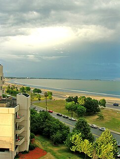
Revere Beach is a public beach in Revere, Massachusetts, located about five miles (8 km) north of downtown Boston. The beach is over three miles (4.8 km) long. In 1875, a rail link was constructed to the beach, leading to its increasing popularity as a summer recreation area, and in 1896, it became the first public beach in the United States. It is still easily accessible by the MBTA Blue Line from Boston, and can accommodate as many as one million visitors in a weekend during its annual sand sculpture competition.

Middlesex Fells Reservation, often referred to simply as the Fells, is a public recreation area covering more than 2,200 acres (890 ha) in Malden, Medford, Melrose, Stoneham, and Winchester, Massachusetts. The state park surrounds two inactive reservoirs, Spot Pond and the Fells Reservoir, and the three active reservoirs that are part of the water supply system for the town of Winchester. Spot Pond and the Fells Reservoir are part of the Wachusett water system, one of six primary water systems that feed metropolitan Boston's waterworks. The park is managed by the Massachusetts Department of Conservation and Recreation and is part of the Metropolitan Park System of Greater Boston.

Alewife Brook Reservation is a Massachusetts state park and urban wild located in Cambridge, Arlington, and Somerville. The park is managed by the state Department of Conservation and Recreation and was established in 1900. It is named for Alewife Brook, which was also historically known as Menotomy River, a tributary of the Mystic River.

Blue Hills Reservation is a 7,000-acre (2,800 ha) state park in Norfolk County, Massachusetts in the United States. Managed by the Massachusetts Department of Conservation and Recreation, it covers parts of Milton, Quincy, Braintree, Canton, Randolph, and Dedham. Located approximately ten miles south of downtown Boston, the reservation is one of the largest parcels of undeveloped conservation land within the Greater Boston metropolitan area. The park's varied terrain and scenic views make it a popular destination for hikers from the Boston area.
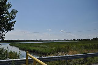
Chelsea Creek, shown on federal maps as the Chelsea River, is a 2.6-mile-long (4.2 km) waterway that runs along the shore of Chelsea, Massachusetts, and separates that community from the cities of Boston and Revere, as well as feeding part of the current Belle Isle Marsh Reservation that separates Boston from Revere. It is one of 10 designated port areas in Massachusetts.

Suffolk Downs station is a rapid transit station on the Massachusetts Bay Transportation Authority (MBTA) Blue Line, located on the east side of Orient Heights in East Boston, Massachusetts, United States. It is named for the now-defunct Suffolk Downs racetrack, located just to the north. Suffolk Downs station has two side platforms, with a footbridge structure of brick, concrete, and steel connecting them. The station is accessible. With just 521 daily boardings in FY 2019, Suffolk Downs is the least-used fare-controlled station on the MBTA subway system.
Dorchester Shores Reservation is a Massachusetts state park consisting of three non-contiguous areas totaling 44 acres (18 ha) along the eastern edge of the Dorchester section of Boston. The area is composed of beaches and a park along the extended mouth of the Neponset River: Savin Hill/Malibu Beach, Tenean Beach, and Victory Road Park. Savin Hill is adjacent to Malibu Beach and has been restored to its original Olmsted Brothers design. The reservation is managed by the Department of Conservation and Recreation.

Cutler Park is a state-owned nature preserve and public recreation area that lies between Route 128/I-95 and the Charles River in Needham, Massachusetts. The state park's 739 acres (299 ha) contain the largest remaining freshwater marsh on the middle Charles River. Parts of its major trail run directly through the marsh via boardwalks; over 100 species of birds have been sighted here. The park is part of a plan by the Town of Needham to connect 18 public areas by 35 proposed trails. It is managed by the Massachusetts Department of Conservation and Recreation.

North Point Park is an 8.5-acre (3.4 ha) park located along the north side of the Charles River in Cambridge, Massachusetts and Boston's West End, created as mitigation for the taking of planned parkland for the construction of the Big Dig.

Winthrop Parkway is a historic parkway in Revere, Massachusetts. The parkway, built between 1909 and 1919 and now designated as part of Route 145, runs for about 0.75 miles (1.21 km), from Eliot Circle southeast to the Revere-Winthrop line. Acquisitions for its construction represent the last public purchase of oceanfront lands in Revere. It was listed on the National Register of Historic Places in 2004.
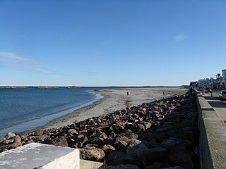
Winthrop Beach is the main beach of Winthrop, Massachusetts. It is located along Winthrop Shore Drive, spanning the roadway. The beach begins off Crest Avenue at an area known as the "Green Bars", named for the green railings along the seawall. The beach ends at the base of Water Tower Hill. The ocean has five wave breakers known as the "Five Sisters" offshore to protect nearby neighborhoods from the large swells that occur during storms.

Pope John Paul II Park Reservation, also known as Pope Park, is a 66-acre (27 ha) Massachusetts state park bordering the Neponset River in the Dorchester section of Boston. The park has been reclaimed from the former site of a landfill and the Neponset Drive-In as part of the Lower Neponset River Master Plan and the development of the Neponset River Reservation. The park is managed by the Department of Conservation and Recreation (DCR).
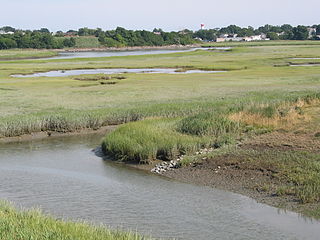
Rumney Marsh Reservation is a Massachusetts state park occupying over 600 acres (240 ha) in the town of Saugus and city of Revere. The salt marsh is located within the Saugus and Pines River estuary and provides habitat for many different migratory birds and marine life. The park is managed by the Massachusetts Department of Conservation and Recreation.

The Metropolitan Park System of Greater Boston is a system of reservations, parks, parkways and roads under the control of the Massachusetts Department of Conservation and Recreation (DCR) in and around Boston that has been in existence for over a century. The title is used by the DCR to describe the areas collectively: "As a whole, the Metropolitan Park System is currently eligible for listing on the National Register of Historic Places", as outlined on the department's website. The DCR maintains a separate Urban Parks and Recreation division to oversee the system, one of five such divisions within the department—DCR's Bureau of State Parks and Recreation manages the remainder of Massachusetts state parks. Direct design and maintenance functions for the parkways and roads within the system are provided by the DCR Bureau of Engineering.

Quincy Shore Reservation is a public recreation area and protected shoreline on Quincy Bay, Boston Harbor, in Quincy, Massachusetts. Its primary attraction is a 2.3-mile-long (3.7 km) beach, accessible along its entire length by Quincy Shore Drive. The largest beach on Boston Harbor, it is known locally as Wollaston Beach, named for the adjacent Wollaston neighborhood.

Halibut Point State Park and Halibut Point Reservation are adjacent parcels of conserved, oceanside land located on Cape Ann in the town of Rockport, Massachusetts. Once the Babson Farm granite quarry, the properties are cooperatively managed by the Trustees of Reservations and the Massachusetts Department of Conservation and Recreation . The adjacent Sea Rocks area is owned by the town of Rockport and is also open to the public.