Roxbury High Fort

Last updated
Roxbury High Fort
FortHillTowerRoxburyMass20040313.jpg
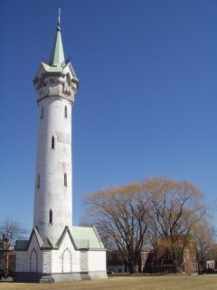
Cochituate Standpipe (built 1869)
USA Massachusetts location map.svg
Red pog.svg
Usa edcp location map.svg
Red pog.svg
Location Boston, Massachusetts
Coordinates 42°19′31″N71°5′40″W / 42.32528°N 71.09444°W / 42.32528; -71.09444
Built1860
ArchitectStandish & Woodbury; Olmsted, Frederick Law
Architectural styleGothic
Part of Roxbury Highlands Historic District (ID89000147)
NRHP reference No. 73000856 [1]
Significant dates
Added to NRHPApril 23, 1973
Designated CPFebruary 22, 1989

Roxbury High Fort is a historic fort site on Beech Glen Street at Fort Avenue in the Roxbury neighborhood of Boston, Massachusetts. The site now contains a small park and the Cochituate Standpipe, also known as Fort Hill Tower, built in 1869. The fort site was added to the National Register of Historic Places in 1973. The site inspired the name of the Fort Hill neighborhood, which surrounds the area of the High Fort.

Contents

History

The Roxbury High Fort site once contained earthwork fortifications of the Continental Army during the Siege of Boston during the American Revolutionary War. At that time Roxbury was an independent town connected to Boston by a narrow neck of land. The hill offered a great vantage of the entire area.

In 1868 Roxbury was annexed to Boston. [2] In 1869, the 70-foot-tall (21 m) Cochituate Standpipe was built atop Fort Hill by the Cochichuate Water Company.

Eventually the water tower was abandoned with other expansions to the Boston water system. By the 1960s, the tower fell into disrepair. The original cast iron balcony was removed. In the early 1980s the City of Boston restored the tower. [3] The area is also today known as Highland Park.

See also

Related Research Articles

<span class="mw-page-title-main">Roxbury, Boston</span> Neighborhood of Boston in Massachusetts, United States

Roxbury is a neighborhood within the City of Boston, Massachusetts, United States.

<span class="mw-page-title-main">Chestnut Hill, Massachusetts</span> Village in Massachusetts, United States

Chestnut Hill is a wealthy New England village located six miles (10 km) west of downtown Boston, Massachusetts, United States. It is best known for being home to Boston College and a section of the Boston Marathon route. Like all Massachusetts villages, Chestnut Hill is not an incorporated municipal entity. It is located partially in Brookline in Norfolk County; partially in the city of Boston in Suffolk County, and partially in the city of Newton in Middlesex County. Chestnut Hill's borders are defined by the 02467 ZIP Code. The name refers to several small hills that overlook the 135-acre Chestnut Hill Reservoir rather than one particular hill.

<span class="mw-page-title-main">Dorchester Heights</span> United States historic place

Dorchester Heights is the central area of South Boston. It is the highest area in the neighborhood and commands a view of both Boston Harbor and downtown.

<span class="mw-page-title-main">Nathaniel Jeremiah Bradlee</span> American architect

Nathaniel Jeremiah Bradlee was a Boston architect and a partner in the firm of Bradlee, Winslow & Wetherell.

<span class="mw-page-title-main">Mission Hill, Boston</span> United States historic place

Mission Hill is a 34 square mile, primarily residential neighborhood of Boston, bordered by Roxbury, Jamaica Plain and Fenway-Kenmore and the town of Brookline. The neighborhood has two main streets, namely Tremont Street and Huntington Ave. It is served by several stations on the MBTA's Green Line E branch, as well as Roxbury Crossing station on the Orange Line.

<span class="mw-page-title-main">Spring Hill, Somerville, Massachusetts</span> United States historic place

Spring Hill is the name of a ridge in the central part of the city of Somerville, Massachusetts, and the residential neighborhood that sits atop it. It runs northwest to southeast, roughly bounded by Highland Avenue, Somerville Avenue, Elm Street, and Willow Avenue. Summer Street runs along the hill's crest.

<span class="mw-page-title-main">Cochituate Aqueduct</span> Brought water to Boston, MA, USA from 1848 to 1951

The Cochituate Aqueduct was an aqueduct in Massachusetts that brought water to Boston from 1848 to 1951.

Bellevue Hill is a neighborhood in West Roxbury comprising the areas roughly between Lagrange Street, Centre Street, and the West Roxbury Parkway. Defined by its leafy streets and stately homes, Bellevue Hill is one of the most upscale neighborhoods outside of Boston's downtown core. Bellevue Hill is also the highest natural point in the city of Boston and Suffolk County. It rises to a height of 330 feet (101m) above sea level.

<span class="mw-page-title-main">Chestnut Hill Reservoir Historic District</span> Historic district in Massachusetts, United States

The Chestnut Hill Reservoir Historic District is a historic district encompassing the Chestnut Hill Reservoir and the surrounding water works facilities which were historically used to provide fresh water to Boston, Massachusetts, and surrounding towns. The district is nearly coextensive with the Chestnut Hill Reservation, a state park managed by the Massachusetts Department of Conservation and Recreation (DCR); those elements of the water works that are still required as an emergency backup are managed by the Massachusetts Water Resources Authority (MWRA). The reservoir is located between Beacon Street and Commonwealth Avenue in Boston's Chestnut Hill district, just east of the Boston College Main Campus Historic District.

<span class="mw-page-title-main">Lake Cochituate</span> Reservoir in Middlesex County, Massachusetts

Lake Cochituate is a body of water in Natick, Wayland, and Framingham, Massachusetts, United States. Originally a reservoir serving Boston, it no longer serves that function, and is now a local recreational resource and home to Cochituate State Park.

<span class="mw-page-title-main">College Hill, St. Louis</span> Neighborhood of St. Louis in Missouri, United States

College Hill is a neighborhood of the City of St. Louis, Missouri. The name College Hill was given to this area because it was the location of the Saint Louis University College Farm. This area, bounded generally by Warne Ave., O'Fallon Park, I-70, Grand Boulevard, and W. Florissant Ave., was acquired by the University for garden and recreation purposes in 1836. It was subdivided in the early 1870s.

<span class="mw-page-title-main">Bellevue Standpipe</span> United States historic place

Bellevue Standpipe is a historic water storage tank on Bellevue Hill at Washington Street and West Roxbury Parkway in the Stony Brook Reservation of Boston, Massachusetts. Built in 1914, it is one of three early 20th-century water tanks built as part of Greater Boston's public water supply. The structure was added to the National Register of Historic Places in 1990.

<span class="mw-page-title-main">First Universalist Church (Somerville, Massachusetts)</span> Historic church in Massachusetts, United States

The First Universalist Church is a historic Universalist Church building at 125 Highland Avenue in Somerville, Massachusetts. The Romanesque church building was built between 1916 and 1923 to a design by Ralph Adams Cram, and is the only example of his work in Somerville. The building was listed on the National Register of Historic Places in 1989. It is currently owned by the Highland Masonic Building Association, and is the home of King Solomon's Lodge AF & AM, the builders of the Bunker Hill Monument.

<span class="mw-page-title-main">First Unitarian Church (Somerville, Massachusetts)</span> Historic church in Massachusetts, United States

The former First Unitarian Church is a historic church building at 130 Highland Avenue in Somerville, Massachusetts. The stone church was built in 1894 for a Unitarian congregation. It was designed by Hartwell & Richardson and is a good example of Richardsonian Romanesque design. The building presently (2022) houses the Mission Church of Our Lord Jesus Christ.

<span class="mw-page-title-main">High Service Water Tower and Reservoir</span> United States historic place

The High Service Water Tower and Reservoir, colloquially known as the Tower Hill Tower, is a public water supply facility off Massachusetts Route 110 in Lawrence, Massachusetts. The reservoir was constructed in 1874–75 to provide the city's public water supply, with a gatehouse designed by Charles T. Emerson, a Lawrence architect. The tower was built in 1896 as a high pressure standpipe or water tower. The tower stands 157 feet (48 m) high, and is built out of red brick with granite trim. It is Romanesque in its style, and was designed by George G. Adams, a noted local architect who had been taught by Emerson. The standpipe inside the tower is of steel construction and is 102 feet (31 m) in height. The area above the standpipe includes a balcony capped by a chateauesque roof, with round-arch windows providing views of the area. The main tower is octagonal in shape, with a narrow round staircase tower projection from one side.

<span class="mw-page-title-main">Forbes Hill Standpipe</span> United States historic place

The Forbes Hill Standpipe is a historic water tower structure located on Reservoir Road in Quincy, Massachusetts, USA. The tower was built in 1899-1902 to contain a 330,000 US gallons steel water tank. The site originally included an adjacent reservoir that supplied Quincy with water from the Metropolitan Boston Water System. The standpipe was taken out of service in 1955 and the reservoir was filled in.

<span class="mw-page-title-main">Fisher Hill Reservoir</span> United States historic place

The Fisher Hill Reservoir and Gatehouse are historic elements of the public water supply for the Greater Boston area.

<span class="mw-page-title-main">Reservoir Park (Massachusetts)</span> United States historic place

Reservoir Park is a historic park on Boylston Street in Brookline, Massachusetts. Its principal feature is Brookline Reservoir, formerly an element of the public water supply for neighboring Boston. The reservoir was built in 1848 as the main terminus of the now-defunct Cochituate Aqueduct, which delivered water from Lake Cochituate in the western suburbs. The reservoir covers 21.1 acres (8.5 ha), and is roughly kidney-shaped. A gravel path extends around the perimeter of the reservoir. The park is bounded on the north by Boylston Street, on the west by Lee Street, on the south by Dudley Street, and on the east by Warren and Walnut Streets.

<span class="mw-page-title-main">Basilica and Shrine of Our Lady of Perpetual Help</span> Historic church in Massachusetts, United States

The Basilica and Shrine of Our Lady of Perpetual Help informally known as The Mission Church is a Roman Catholic basilica in the Mission Hill neighborhood of Boston, Massachusetts. The Redemptorists priests of the Baltimore Province have ministered to the parish since the church was first opened in 1870. The shrine is dedicated to Our Mother of Perpetual Succour.

<span class="mw-page-title-main">Fort Hill, Boston</span> United States historic place

Fort Hill is a 0.4 square mile neighborhood and historic district of Roxbury, in Boston, Massachusetts. The approximate boundaries of Fort Hill are Malcolm X Boulevard on the north, Washington Street on the southeast, and Columbus Avenue on the southwest.

References

  1. "National Register Information System". National Register of Historic Places . National Park Service. April 15, 2008.
  2. Roxbury-profile
  3. Fort Hill tower