
Dorchester is a neighborhood comprising more than 6 square miles (16 km2) in the City of Boston, Massachusetts, United States. Originally, Dorchester was a separate town, founded by Puritans who emigrated in 1630 from Dorchester, Dorset, England, to the Massachusetts Bay Colony. This dissolved municipality, Boston's largest neighborhood by far, is often divided by city planners in order to create two planning areas roughly equivalent in size and population to other Boston neighborhoods.

The Emerald Necklace consists of a 1,100-acre chain of parks linked by parkways and waterways in Boston and Brookline, Massachusetts. It was designed by landscape architect Frederick Law Olmsted, and gets its name from the way the planned chain appears to hang from the "neck" of the Boston peninsula. In 1989, the Emerald Necklace was designated as a Boston Landmark by the Boston Landmarks Commission.

Mattapan is a neighborhood in Boston, Massachusetts, United States. Mattapan is the original Native American name for the Dorchester area, possibly meaning "a place to sit." At the 2010 census, it had a population of 36,480, with the majority of its population immigrants.

The Tremont Street subway in Boston's MBTA subway system is the oldest subway tunnel in North America and the third-oldest still in use worldwide to exclusively use electric traction, opening on September 1, 1897. It was originally built, under the supervision of Howard A. Carson as chief engineer, to get streetcar lines off the traffic-clogged streets, instead of as a true rapid transit line. It now forms the central part of the Green Line, connecting Boylston Street to Park Street and Government Center stations.

The National Register of Historic Places is a United States federal official list of places and sites considered worthy of preservation. In the state of Massachusetts, there are over 4,300 listings, representing about 5% of all NRHP listings nationwide and the second-most of any U.S. state, behind only New York. Listings appear in all 14 Massachusetts counties.

This is a list of the National Register of Historic Places listings in Suffolk County, Massachusetts.

The Bayley House is a historic house at 16 Fairmont Avenue in Newtonville, Massachusetts, US. Built in 1883–84, it is a prominent example of Ruskinian Gothic architecture, designed by the noted firm of Peabody and Stearns. It was listed on the National Register of Historic Places in 1986.

The Arborway consists of a four-lane, divided parkway and a two-lane residential street in the Jamaica Plain neighborhood of Boston, Massachusetts, United States. It was designed by Frederick Law Olmsted in the 1890s as the southern-most carriage road in a series of parkways connecting parks from Boston Common in downtown Boston to Franklin Park in Roxbury. This park system has since become known as the Emerald Necklace.

The Codman Square District is a historic district in the Dorchester neighborhood of Boston, Massachusetts. It consists of four of the most prominent properties facing the main Codman Square intersection, where Talbot Avenue and Washington Street cross. The area has a long history as a major civic center in Dorchester, and is now one of the large neighborhood's major commercial hubs. The properties in the district include the 1806 Congregational Church, the 1904 Codman Square branch of the Boston Public Library, the former Girls Latin Academy building, and the Lithgow Building, a commercial brick structure at the southeast corner of the junction that was built in 1899.

The Dorchester-Milton Lower Mills Industrial District is a historic district on both sides of the Neponset River in the Dorchester area of Boston and in the town of Milton, Massachusetts. It encompasses an industrial factory complex, most of which was historically associated with the Walter Baker & Company, the first major maker of chocolate products in the United States. The industrial buildings of the district were built between about 1868 and 1947. They were listed as part of the district on the National Register of Historic Places in 1980, with a slight enlargement in 2001. The buildings have been adapted for mixed industrial/retail/residential use.
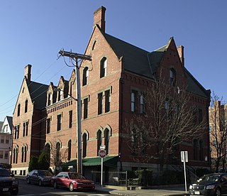
The Fields Corner Municipal Building is a historic municipal building at 1 Arcadia Street and 195 Adams Street in the Dorchester neighborhood of Boston, Massachusetts. Built in 1875, it is a prominent local example of Victorian Gothic architecture, probably designed by the city's first official architect, George A. Clough. The building originally housed a police station and library; it has been adaptively reused for professional and commercial purposes. The building was listed on the National Register of Historic Places in 1981.

Morton Street is a street in southern Boston, Massachusetts, United States. It extends from the southeastern end of the Arborway in Jamaica Plain to Washington Street in the Lower Mills Village of Dorchester. Most of the road is a connecting parkway, signed as part of Massachusetts Route 203, that provides access to Boston's Emerald Necklace of parks. That portion of the road was listed on the National Register of Historic Places in 2005.

The Milton Hill Historic District is a historic district in Milton, Massachusetts. Extending mainly along Adams Street across the top of Milton Hill, it encompasses a residential area of high-style homes dating from the 18th to early 20th centuries. It was listed on the National Register of Historic Places in 1995.

The Commonwealth Avenue Historic District of Newton, Massachusetts, encompasses roughly the eastern half of Commonwealth Avenue, extending from Waban Hill Road, near the city line with Boston, westward to Walnut Street. The roadway was laid out in 1894 and completed in 1895. Its design was influenced in part by the local residents, who were willing to give land for some of the route, and the design of Boston portions of the road, in which Frederick Law Olmsted was involved. Construction of the roadway was followed by the construction of fashionably large residences along its route, which took place mostly between the road's construction and about 1920. The district includes 188 residential properties, which are mainly built in the revival styles popular in the early 20th century. The district was added to the National Register of Historic Places in 1990.

Furnace Brook Parkway is a historic parkway in Quincy, Massachusetts. Part of the Metropolitan Park System of Greater Boston, it serves as a connector between the Blue Hills Reservation and Quincy Shore Reservation at Quincy Bay. First conceived in the late nineteenth century, the state parkway is owned and maintained by the Massachusetts Department of Conservation and Recreation (DCR) and travels through land formerly owned by the families of John Adams and John Quincy Adams, passing several historic sites. It ends in the Merrymount neighborhood, where Quincy was first settled by Europeans in 1625 by Captain Richard Wollaston. The road was started in 1904, completed in 1916 and added to the National Register of Historic Places (NRHP) in 2004.

Blue Hills Parkway is a historic parkway that runs in a straight line from a crossing of the Neponset River, at the south border of Boston to the north edge of the Blue Hills Reservation in Milton, Massachusetts. It was built in 1893 to a design by the noted landscape architect, Charles Eliot, who is perhaps best known for the esplanades along the Charles River. The parkway is a connecting road between the Blue Hills Reservation and the Neponset River Reservation, and was listed on the National Register of Historic Places in 2003.

The Old Harbor Reservation Parkways are three historic roads in the Old Harbor area of Boston. They are part of the Boston parkway system designed by Frederick Law Olmsted. They include

William J. Day Boulevard, or Day Boulevard, is a coastal parkway in Boston, Massachusetts. Beginning at Morrissey Boulevard and Kosciuszko Circle at the northern extent of the Dorchester section of the city, it travels in a gently curving northeasterly direction 2.6 miles (4.2 km) through South Boston along beaches around the west and north shore of Dorchester Bay. It was named for William J. Day.

The Charles River Speedway was a former bicycle and harness racing track located in Allston, Massachusetts, which has been redeveloped into an upscale market.
Boston, Massachusetts is home to many listings on the National Register of Historic Places. This list encompasses those locations that are located south of the Massachusetts Turnpike. See National Register of Historic Places listings in northern Boston for listings north of the Turnpike. Properties and districts located elsewhere in Suffolk County's other three municipalities are also listed separately.


