National Register of Historic Places listings in Franklin County, Massachusetts

Last updated

Location of Franklin County in Massachusetts Map of Massachusetts highlighting Franklin County.svg
Location of Franklin County in Massachusetts

This is a list of the National Register of Historic Places listings in Franklin County, Massachusetts.

Contents

This is intended to be a complete list of the properties and districts on the National Register of Historic Places in Franklin County, Massachusetts, United States. Latitude and longitude coordinates are provided for many National Register properties and districts; these locations may be seen together in a map. [1]

There are 61 properties and districts listed on the National Register in the county, including 1 National Historic Landmark.

Contents: Counties in Massachusetts

Barnstable | Berkshire | Bristol | Dukes | Essex | Franklin | Hampden | Hampshire | Middlesex | Nantucket | Norfolk | Plymouth | Suffolk | Worcester


    This National Park Service list is complete through NPS recent listings posted April 7, 2023. [2]
Map all coordinates using: OpenStreetMap  
Download coordinates as: KML

Current listings

[3] Name on the Register [4] ImageDate listed [5] Location City or townDescription
1 Simeon Alexander Jr. House
Simeon Alexander Jr. House NorthfieldMA SimeonAlexanderJrHouse.jpg
Simeon Alexander Jr. House
May 28, 1991
(#91000598)
496 Millers Falls Rd.
42°38′19″N72°27′55″W / 42.6385°N 72.4652°W / 42.6385; -72.4652 (Simeon Alexander Jr. House)
Northfield
2 Alvah Stone Mill
Alvah Stone Mill Montague - The Bookmill.jpg
Alvah Stone Mill
June 30, 1997
(#97000562)
440 Greenfield Rd.
42°32′16″N72°32′20″W / 42.5378°N 72.5389°W / 42.5378; -72.5389 (Alvah Stone Mill)
Montague Now the Bookmill.
3 Ashfield Plain Historic District
Ashfield Plain Historic District Ashfield Town Offices.JPG
Ashfield Plain Historic District
September 20, 1991
(#91001373)
Roughly along Main and South Sts. and adjacent parts of Buckland and Norton Hill Rds.
42°31′37″N72°47′17″W / 42.5269°N 72.7881°W / 42.5269; -72.7881 (Ashfield Plain Historic District)
Ashfield
4 Bardwell's Ferry Bridge
Bardwell's Ferry Bridge Bardwell's Ferry Bridge viewed from north in 2014.jpg
Bardwell's Ferry Bridge
February 10, 2000
(#00000076)
Bardwell's Ferry Rd. over the Deerfield River
42°33′20″N72°40′41″W / 42.5556°N 72.6781°W / 42.5556; -72.6781 (Bardwell's Ferry Bridge)
Conway
5 Benson's New Block and the Mohawk Chambers
Benson's New Block and the Mohawk Chambers GreenfieldMA BensonsAndMohawkBlocks.jpg
Benson's New Block and the Mohawk Chambers
March 11, 2014
(#14000046)
136-138 & 130-134 Main St. & 11 Wells St.
42°35′17″N72°36′14″W / 42.588°N 72.604°W / 42.588; -72.604 (Benson's New Block and the Mohawk Chambers)
Greenfield
6 Bernardston Congregational Unitarian Church
Bernardston Congregational Unitarian Church Bernardston Congregational Unitarian Church, MA.jpg
Bernardston Congregational Unitarian Church
March 18, 1993
(#93000128)
Junction of Church and Depot Sts.
42°40′14″N72°33′00″W / 42.6706°N 72.55°W / 42.6706; -72.55 (Bernardston Congregational Unitarian Church)
Bernardston
7 Bissell Bridge
Bissell Bridge BISSELL BRIDGE.jpg
Bissell Bridge
February 26, 2004
(#04000083)
Heath Rd., MA 8A over Mill Brook
42°37′57″N72°52′10″W / 42.6325°N 72.8694°W / 42.6325; -72.8694 (Bissell Bridge)
Charlemont
8 Burkeville Covered Bridge
Burkeville Covered Bridge Burkeville Covered Bridge, Conway, MA.jpg
Burkeville Covered Bridge
September 9, 1988
(#88001456)
Main Poland Rd. over the South River
42°30′28″N72°42′40″W / 42.5078°N 72.7111°W / 42.5078; -72.7111 (Burkeville Covered Bridge)
Conway
9 Charlemont Village Historic District
Charlemont Village Historic District Charlemont Town Hall.JPG
Charlemont Village Historic District
February 10, 1988
(#87001880)
MA 2 (Main St.) between South and Harmont Sts.
42°37′40″N72°52′27″W / 42.6278°N 72.8742°W / 42.6278; -72.8742 (Charlemont Village Historic District)
Charlemont
10 Colrain Center Historic District
Colrain Center Historic District Brick Meeting House, Colrain MA.jpg
Colrain Center Historic District
November 15, 2006
(#06001057)
Main, Greenfield, and Jacksonville Rds., Streeter Ln., and River and Coburn Sts.
42°40′24″N72°41′52″W / 42.6733°N 72.6978°W / 42.6733; -72.6978 (Colrain Center Historic District)
Colrain
11 Conway Center Historic District
Conway Center Historic District Conway Town Hall.JPG
Conway Center Historic District
September 10, 1999
(#99001043)
5-38 Academy Hill Rd., 1-59 Elm St., and 8-98 Main St.
42°30′31″N72°41′50″W / 42.5086°N 72.6972°W / 42.5086; -72.6972 (Conway Center Historic District)
Conway
12 Dedic Site
Dedic Site View of South Deerfield, MA.jpg
Dedic Site
July 16, 1980
(#80000504)
Address Restricted
Deerfield Clovis-era paleo-indian site
13 Deerfield Valley Agricultural Society Fairgrounds
Deerfield Valley Agricultural Society Fairgrounds CharlemontMA Fairground Grandstand.jpg
Deerfield Valley Agricultural Society Fairgrounds
May 11, 2011
(#11000267)
Park St.
42°37′51″N72°52′03″W / 42.6308°N 72.8675°W / 42.6308; -72.8675 (Deerfield Valley Agricultural Society Fairgrounds)
Charlemont
14 East Charlemont District School
East Charlemont District School East Charlemont District School, Charlemont MA.jpg
East Charlemont District School
March 7, 2017
(#100000721)
1811 MA 2
42°37′25″N72°47′12″W / 42.6235°N 72.7868°W / 42.6235; -72.7868 (East Charlemont District School)
Charlemont
15 East Hawley Center Historic District
East Hawley Center Historic District Congregational Church, East Hawley MA.jpg
East Hawley Center Historic District
July 24, 1992
(#92000951)
East Hawley, Plainfield, Buckland, and Ashfield Rds.
42°33′48″N72°52′43″W / 42.5633°N 72.8786°W / 42.5633; -72.8786 (East Hawley Center Historic District)
Hawley
16 East Leverett Historic District
East Leverett Historic District Jervis Gilbert House, East Leverett MA.jpg
East Leverett Historic District
January 29, 2014
(#13001131)
Shutesbury, January Hills, Still Corner & Cushman Rds.
42°26′18″N72°28′58″W / 42.4383°N 72.4827°W / 42.4383; -72.4827 (East Leverett Historic District)
Leverett
17 East Main-High Street Historic District
East Main-High Street Historic District GreenfieldMA EastMainHighStreetHD.jpg
East Main-High Street Historic District
March 16, 1989
(#88002011)
Roughly bounded by Church, High, E. Main, and Franklin Sts.
42°35′20″N72°35′49″W / 42.5889°N 72.5969°W / 42.5889; -72.5969 (East Main-High Street Historic District)
Greenfield
18 Franklin County Fairgrounds
Franklin County Fairgrounds GreenfieldMA FranklinCountyFairgroundGate.jpg
Franklin County Fairgrounds
June 15, 2011
(#11000359)
89 Wisdom Way
42°34′44″N72°36′42″W / 42.5789°N 72.6117°W / 42.5789; -72.6117 (Franklin County Fairgrounds)
Greenfield
19 Garden Theater Block
Garden Theater Block GreenfieldMA GardenTheater.jpg
Garden Theater Block
September 1, 1983
(#83000591)
353-367 Main St.
42°35′15″N72°36′01″W / 42.5875°N 72.6003°W / 42.5875; -72.6003 (Garden Theater Block)
Greenfield
20 Gill Center Historic District
Gill Center Historic District Gill, Massachusetts 6.jpg
Gill Center Historic District
November 5, 2018
(#100003068)
Center, Main, Cross, Boyle, River, & Lyons Hill Rds.
42°38′28″N72°29′58″W / 42.6410°N 72.4995°W / 42.6410; -72.4995 (Gill Center Historic District)
Gill
21 Maj. Joseph Griswold House
Maj. Joseph Griswold House BucklandMA GriswoldHouse.jpg
Maj. Joseph Griswold House
February 23, 1972
(#72000130)
Upper St.
42°35′26″N72°47′39″W / 42.5905°N 72.7941°W / 42.5905; -72.7941 (Maj. Joseph Griswold House)
Buckland
22 Heath Center Historic District
Heath Center Historic District Heath Memorial Hall.jpg
Heath Center Historic District
October 25, 2007
(#07001103)
E. and W. Main Sts., 12 and 23 Avery Brook, 8 Taylor Brook, 1-51 Bray, Colrain Stage, 3-16 Ledges, and 15-48 South Rds.
42°40′25″N72°49′19″W / 42.6736°N 72.8219°W / 42.6736; -72.8219 (Heath Center Historic District)
Heath
23 Hill Cemetery and Parson Hubbard House Historic District
Hill Cemetery and Parson Hubbard House Historic District Parson Hubbard House, Shelburne MA.jpg
Hill Cemetery and Parson Hubbard House Historic District
August 23, 2006
(#06000716)
Old Village Rd., 72 Old Village Rd.
42°35′54″N72°41′16″W / 42.5983°N 72.6878°W / 42.5983; -72.6878 (Hill Cemetery and Parson Hubbard House Historic District)
Shelburne
24 King Philip's Hill
King Philip's Hill NorthfieldMA KingPhilipsHill.jpg
King Philip's Hill
December 16, 1981
(#81000106)
Old Bernardston Road
42°41′02″N72°28′35″W / 42.6839°N 72.4764°W / 42.6839; -72.4764 (King Philip's Hill)
Northfield
25 Leavitt-Hovey House
Leavitt-Hovey House Greenfield Public Library, Greenfield, MA.jpg
Leavitt-Hovey House
December 22, 1983
(#83003977)
402 Main St.
42°35′17″N72°35′58″W / 42.5881°N 72.5994°W / 42.5881; -72.5994 (Leavitt-Hovey House)
Greenfield
26 Leverett Center Historic District
Leverett Center Historic District Leverett Congregational Church, Leverett MA.jpg
Leverett Center Historic District
December 5, 2008
(#08001127)
Amherst, Montague, Depot, and Shutesbury Rds.
42°27′05″N72°30′06″W / 42.4513°N 72.5017°W / 42.4513; -72.5017 (Leverett Center Historic District)
Leverett
27 Long Plain Cemetery
Long Plain Cemetery Headstone of Lucy Willard in Hillsboro Cemetery, Leverett, MA (October 2020) 01.jpg
Long Plain Cemetery
June 29, 2020
(#100005304)
19 Depot Rd.
42°27′04″N72°31′30″W / 42.4511°N 72.5250°W / 42.4511; -72.5250 (Long Plain Cemetery)
Leverett Long Plain Cemetery is also known as Hillsboro Cemetery. [6]
28 Main Street Historic District
Main Street Historic District Greenfield Square Marker.JPG
Main Street Historic District
October 13, 1988
(#88001908)
Main St. between Chapman and Hope Sts., also along Bank Row
42°35′13″N72°36′05″W / 42.5869°N 72.6014°W / 42.5869; -72.6014 (Main Street Historic District)
Greenfield
29 Millers Falls Village Historic District
Millers Falls Village Historic District East Main Street, Millers Falls MA.jpg
Millers Falls Village Historic District
November 22, 2021
(#100007171)
Roughly bounded by Bridge, Church, Crescent, East Main, and West Main Sts.
42°34′43″N72°29′41″W / 42.5786°N 72.4947°W / 42.5786; -72.4947 (Millers Falls Village Historic District)
Montague
30 Mohawk Trail
Mohawk Trail Charlemont-Mohawk Trail.JPG
Mohawk Trail
April 3, 1973
(#73000283)
Along the bank of the Cold River
42°38′15″N72°57′13″W / 42.6375°N 72.9536°W / 42.6375; -72.9536 (Mohawk Trail)
Charlemont Extends into Florida and Savoy in Berkshire County
31 Montague Center Historic District
Montague Center Historic District 1858 Town Hall, Montague MA.jpg
Montague Center Historic District
November 16, 2001
(#01001236)
Center, Main, North, School, and Union Sts.
42°32′06″N72°32′05″W / 42.535°N 72.5347°W / 42.535; -72.5347 (Montague Center Historic District)
Montague
32 Moore's Corner Historic District
Moore's Corner Historic District Moores Corner School House, 1810, Leverett MA.jpg
Moore's Corner Historic District
May 19, 2014
(#14000215)
North Leverett, Dudleyville, Rattlesnake Gutter & Church Hill Rds.
42°29′40″N72°28′06″W / 42.4945°N 72.4683°W / 42.4945; -72.4683 (Moore's Corner Historic District)
Leverett
33 New Salem Common Historic District
New Salem Common Historic District NewSalem village common.jpg
New Salem Common Historic District
April 12, 1978
(#78000443)
S. Main St.
42°29′55″N72°19′54″W / 42.4986°N 72.3317°W / 42.4986; -72.3317 (New Salem Common Historic District)
New Salem
34 Newton Street School
Newton Street School GreenfieldMA NewtonStreetSchool.jpg
Newton Street School
October 27, 1988
(#88001907)
70 Shelburne Rd.
42°35′08″N72°36′52″W / 42.5856°N 72.6144°W / 42.5856; -72.6144 (Newton Street School)
Greenfield
35 North Cemetery
North Cemetery North Cemetery, Leverett, MA (October 2020).jpg
North Cemetery
July 1, 2020
(#100005276)
114 Montague Rd.
42°28′03″N72°29′54″W / 42.4675°N 72.4983°W / 42.4675; -72.4983 (North Cemetery)
Leverett
36 North Leverett Historic District
North Leverett Historic District Slarrows Mill, September 2016, North Leverett MA.jpg
North Leverett Historic District
June 13, 2014
(#14000326)
North Leverett, Chestnut Hill, Cave Hill, Jackson Hill, Hemenway & Dickinson Rds.
42°30′28″N72°29′31″W / 42.5079°N 72.492°W / 42.5079; -72.492 (North Leverett Historic District)
Leverett
37 Northfield Center Cemetery
Northfield Center Cemetery NorthfieldMA CenterCemetery 01.jpg
Northfield Center Cemetery
November 13, 2004
(#04001220)
Western terminus of Parker Ave.
42°41′41″N72°27′40″W / 42.6947°N 72.4611°W / 42.6947; -72.4611 (Northfield Center Cemetery)
Northfield
38 Northfield Main Street Historic District
Northfield Main Street Historic District Northfield, Massachusetts.jpg
Northfield Main Street Historic District
July 8, 1982
(#82004965)
Full length of Main St. from Millers Brook to Pauchaug Brook
42°41′50″N72°27′16″W / 42.6972°N 72.4544°W / 42.6972; -72.4544 (Northfield Main Street Historic District)
Northfield
39 Odd Fellows' Hall
Odd Fellows' Hall BucklandMA OddfellowsHall.jpg
Odd Fellows' Hall
May 10, 1979
(#79000345)
1-5 State St.
42°36′13″N72°44′29″W / 42.6035°N 72.7415°W / 42.6035; -72.7415 (Odd Fellows' Hall)
Buckland In Shelburne Falls village of Buckland.
40 Old Deerfield Village Historic District
Old Deerfield Village Historic District Wells-Thorn House, Old Deerfield Street & Memorial Road, Deerfield (Franklin County, Massachusetts).jpg
Old Deerfield Village Historic District
October 15, 1966
(#66000774)
West of U.S. Route 5, bounded by Mill Village Rd., "The Street", Broughton's Pond Rd., and Pogues Hole Rd.
42°33′04″N72°36′30″W / 42.5511°N 72.6083°W / 42.5511; -72.6083 (Old Deerfield Village Historic District)
Deerfield
41 Orange Armory
Orange Armory OrangeMA Armory1.jpg
Orange Armory
August 27, 2020
(#100005477)
135 East Main St.
42°35′24″N72°18′13″W / 42.5901°N 72.3037°W / 42.5901; -72.3037 (Orange Armory)
Orange
42 Orange Center Historic District
Orange Center Historic District Town Hall and Universalist Church, Orange MA.jpg
Orange Center Historic District
April 27, 1989
(#89000057)
Roughly N. and S. Main St. from Prospect St. to River St.
42°35′24″N72°18′39″W / 42.59°N 72.3108°W / 42.59; -72.3108 (Orange Center Historic District)
Orange
43 Pine Street School
Pine Street School NorthfieldMA PineStreetSchool.jpg
Pine Street School
March 13, 2002
(#02000156)
13 Pine St.
42°42′32″N72°26′50″W / 42.7089°N 72.4472°W / 42.7089; -72.4472 (Pine Street School)
Northfield
44 Powers Institute Historic District
Powers Institute Historic District Powers Institute.JPG
Powers Institute Historic District
March 18, 1994
(#93000127)
Church St. between South and Library Sts.
42°40′16″N72°33′12″W / 42.6711°N 72.5533°W / 42.6711; -72.5533 (Powers Institute Historic District)
Bernardston
45 Riverside Archeological District
Riverside Archeological District TurnersFallsMA BridgeAndCanal.jpg
Riverside Archeological District
July 9, 1975
(#75000256)
Address Restricted
Greenfield and Gill
46 Riverside Village Historic District
Riverside Village Historic District IMG 3998 Turner Monument.jpg
Riverside Village Historic District
September 18, 2017
(#100001617)
0-77 French King Hwy., 0-61 Riverview Dr., 1-9 Grove, 2-9 Myrtle, 8 Meadow, 2-23 Oak, 1-4 Pine & 3-32 Walnut Sts.
42°36′41″N72°32′52″W / 42.6114°N 72.5477°W / 42.6114; -72.5477 (Riverside Village Historic District)
Gill
47 Shelburne Falls Historic District
Shelburne Falls Historic District Shelburne Town Hall.JPG
Shelburne Falls Historic District
January 28, 1988
(#87002548)
Bridge and State Sts.
42°36′11″N72°44′25″W / 42.6031°N 72.7403°W / 42.6031; -72.7403 (Shelburne Falls Historic District)
Buckland and Shelburne Boundary increase 2010 approved April 7, 2010): Roughly bounded by Deerfield River, Bridge St., Massachusetts Route 2 and Arms Cemetery
48 Shelburne Free Public Library
Shelburne Free Public Library 1898 Public Library, Shelburne MA.jpg
Shelburne Free Public Library
July 18, 2016
(#16000453)
233 Shelburne Center Rd.
42°35′20″N72°41′19″W / 42.5890°N 72.6887°W / 42.5890; -72.6887 (Shelburne Free Public Library)
Shelburne
49 Arthur A. Smith Covered Bridge
Arthur A. Smith Covered Bridge Arthur A. Smith Covered Bridge, Colrain MA.jpg
Arthur A. Smith Covered Bridge
February 3, 1983
(#83000592)
West of Colrain on Lyonsville Rd.
42°40′12″N72°43′09″W / 42.67°N 72.7192°W / 42.67; -72.7192 (Arthur A. Smith Covered Bridge)
Colrain
50 South School
South School ShutesburyMA SouthSchool 01.jpg
South School
December 26, 2007
(#07001312)
6 Schoolhouse Rd.
42°25′11″N72°26′00″W / 42.4197°N 72.4333°W / 42.4197; -72.4333 (South School)
Shutesbury
51 Sunderland Center Historic District
Sunderland Center Historic District Very old house in sunderland ma.JPG
Sunderland Center Historic District
March 15, 2002
(#02000157)
Roughly along S. Main St.from Old Amherst Rd. to French's Ferry Rd.
42°27′59″N72°34′47″W / 42.4664°N 72.5796°W / 42.4664; -72.5796 (Sunderland Center Historic District)
Sunderland
52 Old Tavern Farm
Old Tavern Farm Old Tavern Farm, Greenfield MA.jpg
Old Tavern Farm
March 10, 2005
(#05000120)
817 Colrain Rd.
42°37′20″N72°38′09″W / 42.6222°N 72.6358°W / 42.6222; -72.6358 (Old Tavern Farm)
Greenfield
53 Turners Falls Historic District
Turners Falls Historic District TurnersFalls Canal.jpg
Turners Falls Historic District
May 2, 1982
(#82004966)
Roughly bounded by the Connecticut River, Power Canal, and 9th and L Sts.
42°36′30″N72°33′23″W / 42.6083°N 72.5564°W / 42.6083; -72.5564 (Turners Falls Historic District)
Montague Listed as Turner Falls Historic District
54 US Post Office-Greenfield Main
US Post Office-Greenfield Main GreenfieldMA PostOffice.jpg
US Post Office-Greenfield Main
December 20, 1985
(#85003224)
442 Main St.
42°35′15″N72°35′53″W / 42.5875°N 72.5981°W / 42.5875; -72.5981 (US Post Office-Greenfield Main)
Greenfield
55 Weldon Hotel
Weldon Hotel The Weldon, Greenfield, MA.jpg
Weldon Hotel
August 6, 1980
(#80000503)
54 High St.
42°35′26″N72°35′44″W / 42.5906°N 72.5956°W / 42.5906; -72.5956 (Weldon Hotel)
Greenfield
56 Wendell Town Common Historic District
Wendell Town Common Historic District Meetinghouse, Wendell MA.jpg
Wendell Town Common Historic District
May 21, 1992
(#92000580)
Junction of Depot, Lock's Village, Montague and Morse Village Rds.
42°32′55″N72°23′51″W / 42.5486°N 72.3975°W / 42.5486; -72.3975 (Wendell Town Common Historic District)
Wendell
57 West Whately Historic District
West Whately Historic District West Whately Chapel, Whately MA.jpg
West Whately Historic District
October 10, 2003
(#03001018)
Address Restricted [7]
42°26′18″N72°40′55″W / 42.4383°N 72.682°W / 42.4383; -72.682 (West Whately Historic District)
Whately
58 Whately Center Historic District
Whately Center Historic District Whately Town Hall.JPG
Whately Center Historic District
September 11, 2003
(#03000920)
155-215 Chestnut Plain Rd. and 330-348 Haydenville Rd.
42°26′18″N72°38′09″W / 42.4383°N 72.6358°W / 42.4383; -72.6358 (Whately Center Historic District)
Whately
59 Whitaker-Clary House
Whitaker-Clary House NewSalemMA WhitakerClaryHouse.jpg
Whitaker-Clary House
June 18, 1975
(#75000257)
Elm St.
42°32′26″N72°18′58″W / 42.5406°N 72.3161°W / 42.5406; -72.3161 (Whitaker-Clary House)
New Salem Home of the Swift River Historical Society
60 The Wilder Homestead
The Wilder Homestead BucklandMA WilderHomestead.jpg
The Wilder Homestead
January 24, 2011
(#10001178)
Ashfield Rd.
42°35′59″N72°46′44″W / 42.5997°N 72.7789°W / 42.5997; -72.7789 (The Wilder Homestead)
Buckland About 1/4 mile south of the Upper Road/Ashfield Road junction.
61 Robert Strong Woodward House and Studio
Robert Strong Woodward House and Studio Robert Strong Woodward Home and Studio.jpg
Robert Strong Woodward House and Studio
January 11, 2018
(#100001961)
43 Upper St.
42°35′16″N72°47′44″W / 42.5877°N 72.7955°W / 42.5877; -72.7955 (Robert Strong Woodward House and Studio)
Buckland

See also

Related Research Articles

<span class="mw-page-title-main">National Register of Historic Places listings in Essex County, Massachusetts</span>

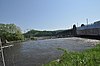
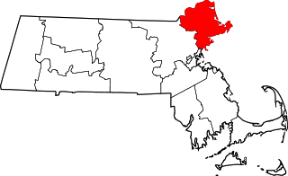
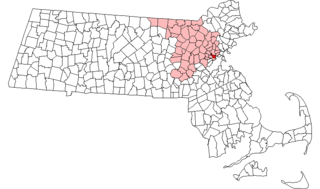
This list is of that portion of the National Register of Historic Places (NRHP) designated in Essex County, Massachusetts. The locations of these properties and districts for which the latitude and longitude coordinates are included below, may be seen in a map.

<span class="mw-page-title-main">National Register of Historic Places listings in Hampden County, Massachusetts</span>

This is a list of the National Register of Historic Places listings in Hampden County, Massachusetts.

<span class="mw-page-title-main">National Register of Historic Places listings in Suffolk County, Massachusetts</span>

This is a list of the National Register of Historic Places listings in Suffolk County, Massachusetts.

<span class="mw-page-title-main">National Register of Historic Places listings in Hampshire County, Massachusetts</span>

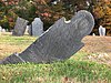
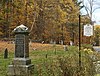
This is a list of properties on the National Register of Historic Places in Hampshire County, Massachusetts.

<span class="mw-page-title-main">National Register of Historic Places listings in Dukes County, Massachusetts</span>

This is a list of the National Register of Historic Places listings in Dukes County, Massachusetts.

<span class="mw-page-title-main">National Register of Historic Places listings in Lewis County, New York</span>

List of the National Register of Historic Places listings in Lewis County, New York

<span class="mw-page-title-main">National Register of Historic Places listings in Somerville, Massachusetts</span>

This is a list of properties and historic districts in Somerville, Massachusetts, that have been listed on the National Register of Historic Places.

This is a list of properties and historic districts in Milton, Massachusetts, that are listed on the National Register of Historic Places.

<span class="mw-page-title-main">National Register of Historic Places listings in Franklin County, Pennsylvania</span>

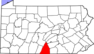
This is a list of the National Register of Historic Places listings in Franklin County, Pennsylvania.

<span class="mw-page-title-main">National Register of Historic Places listings in Franklin County, Florida</span>

This is a list of the National Register of Historic Places listings in Franklin County, Florida.

<span class="mw-page-title-main">National Register of Historic Places listings in Franklin County, Iowa</span>

This is a list of the National Register of Historic Places listings in Franklin County, Iowa.

<span class="mw-page-title-main">National Register of Historic Places listings in Andover, Massachusetts</span>

This is a list of the National Register of Historic Places listings in Andover, Massachusetts.

<span class="mw-page-title-main">National Register of Historic Places listings in Franklin County, Idaho</span>

This is a list of the National Register of Historic Places listings in Franklin County, Idaho.

<span class="mw-page-title-main">National Register of Historic Places listings in Franklin County, North Carolina</span>

This list includes properties and districts listed on the National Register of Historic Places in Franklin County, North Carolina. Click the "Map of all coordinates" link to the right to view an online map of all properties and districts with latitude and longitude coordinates in the table below.

<span class="mw-page-title-main">National Register of Historic Places listings in Lawrence, Massachusetts</span>

The following properties are listed on the National Register of Historic Places in Lawrence, Massachusetts.

<span class="mw-page-title-main">National Register of Historic Places listings in Franklin County, Indiana</span>

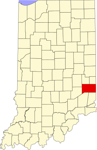
This is a list of the National Register of Historic Places listings in Franklin County, Indiana.

<span class="mw-page-title-main">National Register of Historic Places listings in Salem, Massachusetts</span>

This is a list of the National Register of Historic Places listings in Salem, Massachusetts.

<span class="mw-page-title-main">National Register of Historic Places listings in Ipswich, Massachusetts</span>

This is a list of the National Register of Historic Places listings in Ipswich, Massachusetts.

<span class="mw-page-title-main">National Register of Historic Places listings in Franklin County, Missouri</span>

This is a list of the National Register of Historic Places listings in Franklin County, Missouri.

This is a list of the National Register of Historic Places listings in Cape Cod National Seashore.

References

  1. The latitude and longitude information provided in this table was derived originally from the National Register Information System, which has been found to be fairly accurate for about 99% of listings. Some locations in this table may have been corrected to current GPS standards.
  2. National Park Service, United States Department of the Interior, "National Register of Historic Places: Weekly List Actions", retrieved April 7, 2023.
  3. Numbers represent an alphabetical ordering by significant words. Various colorings, defined here, differentiate National Historic Landmarks and historic districts from other NRHP buildings, structures, sites or objects.
  4. "National Register Information System". National Register of Historic Places . National Park Service. March 13, 2009.
  5. The eight-digit number below each date is the number assigned to each location in the National Register Information System database, which can be viewed by clicking the number.
  6. "Historical Commission Meeting: Monday, August 19, 2019". Town of Leverett Historical Commission. Section 3. Cemeteries: Leverett, Massachusetts. Retrieved 19 October 2020. Eva, Edie and Susan M. met with Michelle Johnstone from PAL, Providence RI, hired by MHC to research and submit National Register applications for North and Long Plain/Hillsboro Cemeteries.{{cite web}}: CS1 maint: location (link)
  7. Coordinates provided are for what appears to be West Whately, at the intersection of Conway, Poplar Hill, and Williamsburg Roads; the NRIS provides no coordinates.