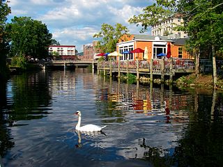
Pawcatuck is a village and census-designated place (CDP) in the town of Stonington which is located in New London County, Connecticut. The population was 5,624 at the 2010 census. It is located across the Pawcatuck River from Downtown Westerly, Rhode Island. The Mechanic Street Historic District of Pawcatuck is listed on the National Register of Historic Places and includes sites of shipbuilding, mills, and worker housing in a 147-acre (0.59 km2) area.

North Eastham is a census-designated place (CDP) in the town of Eastham in Barnstable County, Massachusetts, United States. The population was 1,806 at the 2010 census.

North Falmouth is a census-designated place (CDP) in the town of Falmouth in Barnstable County, Massachusetts, United States. The population was 3,084 at the 2010 census.

West Falmouth is a census-designated place (CDP) in the town of Falmouth in Barnstable County, Massachusetts, United States. The population was 1,738 at the 2010 census.

Housatonic is a census-designated place (CDP) in the town of Great Barrington in Berkshire County, Massachusetts. It is part of the Pittsfield, Massachusetts Metropolitan Statistical Area. The population was 1,109 at the 2010 census. It was named after the Housatonic River.

Turners Falls is an unincorporated village and census-designated place in the town of Montague in Franklin County, Massachusetts, United States. The population was 4,512 at the 2020 census. It is part of the Springfield, Massachusetts Metropolitan Statistical Area. Its name is sometimes used as a metonym for the entire town of Montague, for which it is the business district and comprises more than half the population.

Loveland Park is a census-designated place (CDP) located in Symmes Township, Hamilton County and Deerfield Township, Warren County, in the southwestern part of the U.S. state of Ohio. The CDP is named after the city of Loveland. The population was 1,737 at the 2020 census.

Great Barrington is a census-designated place (CDP) located in the town of Great Barrington in Berkshire County, Massachusetts, United States. The population was 2,231 at the 2010 census, out of 7,104 in the entire town of Great Barrington.

Andover is a census-designated place (CDP) in the town of Andover in Essex County, Massachusetts, United States. The population was 8,762 at the 2010 census.

Boxford is a census-designated place (CDP) in the town of Boxford in Essex County, Massachusetts, United States. The population was 2,339 at the 2010 census.

Essex CDP is a census-designated place (CDP) in the town of Essex in Essex County, Massachusetts, United States. The population was 1,471 at the 2010 census.

Ipswich is a census-designated place (CDP) located in the town of Ipswich in Essex County, Massachusetts, United States. The population was 4,222 at the 2010 census.

Rockport is a census-designated place (CDP) in the town of Rockport in Essex County, Massachusetts, United States. The population was 4,966 at the 2010 census.

Rowley is a census-designated place (CDP) in the town of Rowley in Essex County, Massachusetts, United States. The population was 1,416 at the 2010 census.

Topsfield is a census-designated place (CDP) in the town of Topsfield in Essex County, Massachusetts, United States. The population was 2,717 at the 2010 census.

Lealman, known as East Lealman until 2010, is a census-designated place (CDP) in Pinellas County, Florida, United States. The population was 19,879 at the 2010 census. Prior to 2010, Lealman was part of a larger CDP named West and East Lealman.

Clayville is a census-designated place mostly in the town of Foster and the remainder in Scituate in Providence County, Rhode Island, United States. As of the 2010 census, it had a population of 300. It is the location of the Clayville Historic District.

Casco is a census-designated place (CDP) in the town of Casco in Cumberland County, Maine, United States. The population of the CDP was 587 at the 2010 census. It is part of the Portland–South Portland–Biddeford, Maine Metropolitan Statistical Area.

Falmouth is a census-designated place (CDP) within the town of Falmouth in Cumberland County, Maine, United States. The population was 1,855 at the 2010 census. It is part of the Portland–South Portland–Biddeford, Maine Metropolitan Statistical Area.

Little Falls is a census-designated place (CDP) in the town of Gorham in Cumberland County, Maine, United States. The population of the CDP was 708 at the 2010 census. Prior to 2010, Little Falls was part of the Little Falls-South Windham census-designated place.


