Franklin County is a nongovernmental county located in the northwestern part of the U.S. state of Massachusetts. As of the 2020 census, the population was 71,029, which makes it the least-populous county on the Massachusetts mainland, and the third-least populous county in the state. Its traditional county seat and most populous city is Greenfield. Its largest town by area is New Salem. Franklin County comprises the Greenfield Town, MA Micropolitan Statistical Area, which is included in the Springfield-Greenfield Town, MA Combined Statistical Area.

Charlemont is a town in Franklin County, Massachusetts, United States. The population was 1,185 at the 2020 census. It is part of the Springfield, Massachusetts Metropolitan Statistical Area.
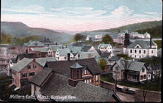
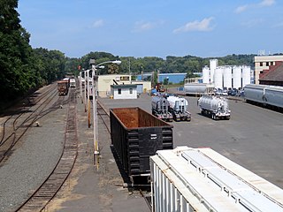
Millers Falls is a census-designated place (CDP) in the towns of Montague and Erving in Franklin County, Massachusetts, United States. The population was 1,139 at the 2010 census. It is part of the Springfield, Massachusetts metropolitan statistical area.

Rowe is a town in Franklin County, Massachusetts, United States. The population was 424 at the 2020 census.

South Ashburnham is a census-designated place (CDP) in the town of Ashburnham in Worcester County, Massachusetts, United States. The population was 1,062 at the 2010 census.

Otto is a town in Cattaraugus County, New York, United States. The population was 775 at the 2020 census. The name comes from Jacob S. Otto, an agent of the Holland Land Company. The town lies on the northern border of Cattaraugus County.
Bondsville is an area and former census-designated place (CDP) located in the town of Palmer in Hampden County in the western part of the U.S. state of Massachusetts. The population of the CDP was 1,876 at the 2000 census. It is part of the Springfield, Massachusetts Metropolitan Statistical Area. The village was named after Emelius Bond who first secured the water rights of the Swift River in 1846 to form the Bond Village Manufacturing Company.

Cleveland Circle is an area of Boston, Massachusetts. It is located at the southern tip of Boston's Brighton neighborhood, and more specifically the Aberdeen section of Brighton, in close proximity to Brookline and Chestnut Hill, Massachusetts, at the intersection of Beacon Street and Chestnut Hill Avenue.

Deerfield River is a river that runs for 76 miles (122 km) from southern Vermont through northwestern Massachusetts to the Connecticut River. The Deerfield River was historically influential in the settlement of western Franklin County, Massachusetts, and its namesake town. It is the Connecticut River's second-longest tributary in Massachusetts, 2.1 miles (3.4 km) shorter than Metropolitan Springfield's Westfield River.

The Fitchburg Railroad is a former railroad company, which built a railroad line across northern Massachusetts, United States, leading to and through the Hoosac Tunnel. The Fitchburg was leased to the Boston and Maine Railroad in 1900. The main line from Boston to Fitchburg is now operated as the MBTA Fitchburg Line; Pan Am Railways runs freight service on some other portions.

The Chehalis–Centralia Railroad (CHTX) is a heritage railroad based in Chehalis, Washington.
The Nashua River Rail Trail is a 12.5-mile (20.1 km) paved mixed-use rail trail in northern Massachusetts and southern New Hampshire under control of the Massachusetts Department of Conservation and Recreation (DCR). It roughly follows the course of the Nashua River, passing through the towns of Ayer, Groton, Pepperell, and Dunstable, Massachusetts and ends about a mile across the New Hampshire state border in Nashua, New Hampshire. The trail is used by walkers, cyclists, inline skaters, equestrians, and cross-country skiers.
The Burnshirt River is a 12.9-mile-long (20.8 km) stream in Worcester County, Massachusetts. It is a tributary of the Ware River, draining ultimately into the Connecticut River and thence the Long Island Sound.
Athol Junction is a place in Springfield, Massachusetts, named after the rail line that split off to Athol, Massachusetts, before The Quabbin Reservoir was flooded. It is located next to I-291 and the tracks now are used for the industrial park and extend to Indian Orchard before stopping. When the line was active the tracks extended over the Chicopee River, into Ludlow, Massachusetts, and on to Athol.

Davis, Massachusetts, is the abandoned location of the Davis Pyrite Mine, located in the town of Rowe, Massachusetts. Once the largest iron pyrite mine in Massachusetts, Davis grew to be a decent sized mining village at the beginnings of the Second Industrial Revolution (1870–1915). But in 1911, a non-fatal collapse of the mine due to "poor mining practices" ended the nearly 30-year run. By 1937, the mining camp had faded, and all that remained were a blacksmith shop and about 150 cellar holes.
North Cambridge, also known as "Area 11", is a neighborhood of Cambridge, Massachusetts bounded by Porter Square and the Fitchburg Line railroad tracks on the south, the city of Somerville on the northeast, Alewife Brook and the town of Arlington on the northwest, and the town of Belmont on the west. In 2005 it had a population of 10,642 residents living in 4,699 households, and the average income was $44,784. In 2010, the racial demographics for the neighborhood were 57.6% White, 20% Black, 15.1% Asian/Pacific Islander, 7.3% Hispanic origin, 0.3% Native American, 2.4% other race.

Zoar is a hamlet in the town of Collins in Erie County, New York, United States. Though it is in Collins, mail is postmarked to the Gowanda ZIP code of 14070. It is located on the northern side of Zoar Valley.