
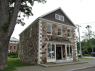
The Ashburnham Center Historic District is a historic district encompassing the core of the village center of Ashburnham, Massachusetts in the United States. It is a well-preserved industrial village that experienced its most significant period of growth in the mid-19th century. The district was added to the National Register of Historic Places in 1999.

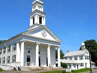
The Harvard Center Historic District is a historic district encompassing the traditional village center of Harvard, Massachusetts, USA. The district is centered on the town common, a triangular grassy space bounded by Elm Street, Still River Road, and Ayer Road. The common is ringed by residences, civic and religious buildings, and a small commercial area. The common was laid out when the town was founded in 1732, and has grown, mainly in periods of growth at the late 18th and late 19th/early 20th centuries. Most of the village's buildings post-date 1831. The district was added to the National Register of Historic Places in 1997.

The Millis Center Historic District is an historic district on Curve, Daniels, Exchange, Irving, Lavender, Main, and Union Streets in Millis, Massachusetts. It encompasses the historic mid-to-late-19th century village center of the town, including the residential area north of Main Street, two 19th-century industrial complexes, and civic and institutional buildings. It was added to the National Register of Historic Places in 2007.

The Monument Square–Eagle Street Historic District is a historic district encompassing the civic heart of North Adams, Massachusetts. When it was originally designated in 1972, the district encompassed Monument Square – west of the intersection of Main Street and Church Street, and the location of a Civil War memorial – and the area around it. This designation included the North Adams Public Library, the First Baptist Church and First Congregational Church, and a block of shops Eagle Street. In 1988, the district's boundaries were increased to be roughly bounded by Holden, Center and Union Streets, the East Middle School, Summer Street, and Main Street. This expansion extended the district westward along Summer Street to include the US Post Office building and St. John's Church, and eastward to include Colgrove Park, the middle school, and St. Francis Catholic Church. An additional block of commercial buildings was also added on the north side of West Main Street, extending just west of Holden Street.
The Sheffield Center Historic District encompasses the historic village center of Sheffield, Massachusetts. The village extends linearly along United States Route 7, roughly between Maple Avenue and Berkshire School Road, and includes the town's major civic and religious buildings. The area's principal period of development was between 1760 and the 1890s. It was listed on the National Register of Historic Places in 1989.

The Sheffield Plain Historic District encompasses the original 18th-century village center of Sheffield, Massachusetts, United States. The linear district extends southward about 0.5 miles (0.80 km) from the junction of United States Route 7 and Cook Road, where the original town common is located. The district was primarily developed in the mid-18th and early 19th centuries. It was listed on the National Register of Historic Places in 1988.

The East Hawley Center Historic District encompasses the principal institutional center of the town of Hawley, Massachusetts, with a history dating to the 1780s. Although it was settled in the late 18th century, issues with Hawley's boundaries meant that the development of a central village did not take place until later. East Hawley was developing as a local transportation hub by the mid-1820s, with several roads converging in the area. The establishment of a store and post office, and the relocation of the Congregational Church into the area cemented its importance in the town's civic life. There was some industrial mill activity in the area during the 19th century, but this came to an end near the end of the century, and only a mill pond remains. The district was listed on the National Register of Historic Places in 1992.

The Agawam Center Historic District is a historic district that encompasses part of the historic center of Agawam, Massachusetts. The district covers most of the buildings along Elm Street and Main Street radiating out from their intersection in both directions. The district is predominantly residential, although it does contain many commercial, industrial, and civic buildings. Many of the buildings in the district stand at a uniform setback from the street, giving the district a coherent feel.

The West Granville Historic District is a historic district encompassing the center of West Granville, Massachusetts. The village is composed mainly of buildings form the late 18th and early 19th centuries, including an 18th-century church and 1830s academy building. The district was listed on the National Register of Historic Places in 1991.

The Bradford Common Historic District is a historic district encompassing the former town center of Bradford, now a village of Haverhill, Massachusetts. Centered on the former town common at South Main and Salem Streets, the area served as Bradford's civic and commercial center from about 1750 until its annexation by Haverhill in 1897, and retains architecture from the 18th to early 20th centuries. It was added to the National Register of Historic Places in 1977.

The Chesterfield Center Historic District is a historic district that encompasses the traditional village center of the town of Chesterfield, Massachusetts. The village is reflective of the town's 18th and 19th-century development as an agrarian hill community, with architectural styles before about 1850 predominating. The district was listed on the National Register of Historic Places in 2000.

The West Chesterfield Historic District is a historic district that encompasses the 19th century industrial and residential heritage of the village of West Chesterfield in the town of Chesterfield, Massachusetts. Centered at the junction of Main Road and Ireland Street, it was one of the town's main industrial sites for many years. The district was listed on the National Register of Historic Places in 2008.

The Jaffrey Center Historic District encompasses the traditional civic heart of the small town of Jaffrey, New Hampshire. The district lies to the west of the Jaffrey's main business district, extending along Main Street from Harkness Road to the Jaffrey Common, and along Thorndike Pond Road northward from Main Street. It includes the town's oldest civic buildings, and was its main center until the mills of East Jaffrey eclipsed it. The district was listed on the National Register of Historic Places in 1975.

The Danville Town House is the town hall of Danville, New Hampshire. It is located at 210 Main Street. The 2+1⁄2-story wood-frame building was completed in 1887, replacing the old 18th-century meetinghouse. It houses the town offices, and a meeting space in which town meetings and other civic and social events take place. The building was listed on the National Register of Historic Places in 2000.

The Town Center Historic District encompasses the historic village center of South Hampton, New Hampshire. Centered around the Barnard Green, the town common, on New Hampshire Route 107A, it includes architectural reminders of the town's growth and change over time. The district was listed on the National Register of Historic Places in 1983.

The South Berwick Village Historic District encompasses the historic village center of South Berwick, Maine. First settled in the 1640s, the village developed along a major route between Boston, Massachusetts and Portland, Maine in the early 19th century. The village has about 150 years of architecture reflective of this history, and was listed on the National Register of Historic Places in 2010.
The Plymouth Center Historic District encompasses historic early village center of Plymouth, Connecticut. Stretching along Main, North and South Streets from their junction, it flourished in the 19th century with small-scale industries, but declined late in the century with the separation of Thomaston and the more significant industrial development at Terryville. The district features colonial, Federal, and Greek Revival architecture and was added to the National Register of Historic Places in 1999, with a slight enlargement the following year.

The Weston Village Historic District encompasses the town center and principal village of Weston, Vermont. Centered on Farrar Park, which serves as the town green, it includes a diversity of architectural styles from the late 18th century to about 1935, and includes residential, civic, commercial, industrial and religious buildings. It was listed on the National Register of Historic Places in 1985.

The Rocky Hill Center Historic District encompasses the traditional town center and surrounding residential area of Rocky Hill, Connecticut. It extends along Old Main Street from the Wethersfield line southward to a triangular area bounded by Old Main, Riverview Road, and Glastonbury Avenue. Included in a basically 19th-century streetscape are the town's principal civic and religious buildings, as well as a fine collection of mainly 18th and 19th-century residential architecture. The district was listed on the National Register of Historic Places in 2007.
The South Chatham Village Historic District is a historic district encompassing much of the linear village of South Chatham in Chatham, Massachusetts. Extending eastward from the Harwich town line along Main Street, the district developed in the 18th and 19th centuries as a maritime and farming village. The district was listed on the National Register of Historic Places in 2022.


