Current listings
| [2] | Name on the Register [3] | Image | Date listed [4] | Location | City or town | Description |
|---|---|---|---|---|---|---|
| 1 | Abel Allen House | 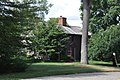 | January 9, 1978 (#78000465) | South of Weston at 1 Chestnut St. 42°21′16″N71°18′17″W / 42.354444°N 71.304722°W | Weston | |
| 2 | Boston Post Road Historic District |  | February 11, 1983 (#83000783) | Both sides of the Boston Post Rd. from Plain Rd. to Stony Brook 42°21′57″N71°18′30″W / 42.365833°N 71.308333°W | Weston | |
| 3 | Case's Corner Historic District |  | September 12, 2002 (#02001038) | School, Wellesley, Newton and Ash Sts. 42°21′29″N71°17′55″W / 42.358056°N 71.298611°W | Weston | |
| 4 | Charles River Reservation Parkways |  | January 18, 2006 (#05001530) | Soldiers Field, Nonantum, Leo Birmingham, Arsenal, Greenough, N. Beacon, Charles River, Norumbega, Recreation 42°21′42″N71°09′31″W / 42.361667°N 71.158611°W | Weston | Extends into Cambridge, Newton, Waltham, and Watertown in Middlesex County and into Boston in Suffolk County |
| 5 | Glen Road Historic District | 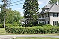 | September 6, 2006 (#06000783) | 233–317 Glen Rd. 42°19′32″N71°17′17″W / 42.325556°N 71.288056°W | Weston | |
| 6 | Golden Ball Tavern |  | September 28, 1972 (#72000141) | 662 Boston Post Rd. 42°21′57″N71°18′35″W / 42.365833°N 71.309722°W | Weston | |
| 7 | Harrington House |  | June 22, 1976 (#76000281) | 555 Wellesley St. 42°19′38″N71°18′39″W / 42.327222°N 71.310833°W | Weston | |
| 8 | Isaac Hobbs House | 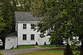 | June 1, 1982 (#82002747) | 87 North Ave. 42°22′48″N71°16′54″W / 42.38°N 71.281667°W | Weston | |
| 9 | Kendal Green Historic District | 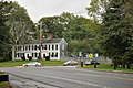 | March 1, 2000 (#01000121) | North Ave., Church, Viles Sts., Brook Rd. 42°22′59″N71°17′11″W / 42.383056°N 71.286389°W | Weston | |
| 10 | Edward Peirce House-Henderson House of Northeastern University |  | August 19, 1997 (#97000880) | 99 Westcliff Rd. 42°19′23″N71°17′52″W / 42.323056°N 71.297778°W | Weston | |
| 11 | Silver Hill Historic District |  | August 25, 2004 (#04000902) | Silver Hill, Westland Rds., Merriam St. 42°23′34″N71°18′18″W / 42.392778°N 71.305°W | Weston | |
| 12 | Samuel Train House |  | December 12, 1976 (#76000286) | 342 Winter St. 42°19′20″N71°19′31″W / 42.322222°N 71.325278°W | Weston | |
| 13 | Wellington Farm Historic District |  | April 14, 1988 (#88000426) | 487–500 Wellesley St. 42°19′58″N71°18′25″W / 42.332778°N 71.306944°W | Weston | |
| 14 | Weston Aqueduct Linear District | 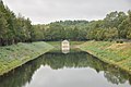 | January 18, 1990 (#89002274) | Along the Weston Aqueduct from the Sudbury Reservoir to the Weston Reservoir 42°20′00″N71°22′32″W / 42.333333°N 71.375556°W | Weston | Extends into Southborough, Worcester County and Framingham and Wayland in Middlesex County. |
| 15 | Rev. Samuel Woodward House | 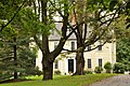 | October 8, 1976 (#76000283) | 19 Concord Rd. 42°22′05″N71°18′21″W / 42.368056°N 71.305833°W | Weston |
