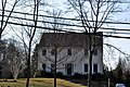
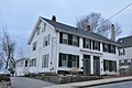
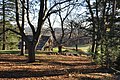
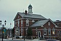
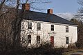
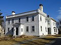
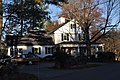
[ 4] Name on the Register [ 2] Image Date listed [ 5] Location City or town Description 1 Abbot Tavern Abbot Tavern June 10, 1982 (# 82004810 70 Elm St. 42°39′38″N 71°08′13″W / 42.660506°N 71.136972°W / 42.660506; -71.136972 (Abbot Tavern ) Andover 2 Asa and Sylvester Abbot House Upload image 1982-06-(# 82004833 15-17 Porter Rd. 42°38′21″N 71°08′08″W / 42.639167°N 71.135556°W / 42.639167; -71.135556 (Asa and Sylvester Abbot House ) Andover Incorrectly listed on the register at 15-17 Andover Street. 3 Benjamin Abbot House Benjamin Abbot House February 24, 1975 (# 75000242 9 Andover St. 42°38′47″N 71°09′11″W / 42.646389°N 71.153056°W / 42.646389; -71.153056 (Benjamin Abbot House ) Andover 4 J. T. Abbot House J. T. Abbot House June 10, 1982 (# 82004814 34 Essex St. 42°39′23″N 71°08′37″W / 42.656389°N 71.143611°W / 42.656389; -71.143611 (J. T. Abbot House ) Andover 5 Abbot-Baker House Abbot-Baker House June 10, 1982 (# 82004811 5 Argilla Rd. 42°38′49″N 71°09′12″W / 42.646886°N 71.153408°W / 42.646886; -71.153408 (Abbot-Baker House ) Andover 6 Abbot-Battles House Abbot-Battles House June 10, 1982 (# 82001905 31 Lowell St. 42°40′17″N 71°09′15″W / 42.671389°N 71.154167°W / 42.671389; -71.154167 (Abbot-Battles House ) Andover 7 Abbot-Stinson House Abbot-Stinson House March 9, 1990 (# 90000190 6 Stinson Rd. 42°38′15″N 71°07′20″W / 42.6375°N 71.122222°W / 42.6375; -71.122222 (Abbot-Stinson House ) Andover 8 Academy Hill Historic District Academy Hill Historic District October 7, 1982 (# 82000475 MA 28 42°38′48″N 71°08′07″W / 42.646667°N 71.135278°W / 42.646667; -71.135278 (Academy Hill Historic District ) Andover Encompasses Phillips Academy, Abbot Academy, Andover Theological Seminary. 9 Andover National Bank Andover National Bank June 10, 1982 (# 82001907 23 Main St. 42°39′20″N 71°08′26″W / 42.655556°N 71.140556°W / 42.655556; -71.140556 (Andover National Bank ) Andover 10 Andover Town Hall Andover Town Hall June 10, 1982 (# 82004961 20 Main St. 42°39′21″N 71°08′25″W / 42.655833°N 71.140278°W / 42.655833; -71.140278 (Andover Town Hall ) Andover 11 Andover Village Industrial District Andover Village Industrial District October 7, 1982 (# 82000476 MA 28 42°39′20″N 71°08′54″W / 42.655556°N 71.148333°W / 42.655556; -71.148333 (Andover Village Industrial District ) Andover 12 Arden Arden June 10, 1982 (# 82004812 276 N. Main St. 42°40′05″N 71°08′57″W / 42.668056°N 71.149167°W / 42.668056; -71.149167 (Arden ) Andover 13 Timothy P. Bailey House Timothy P. Bailey House June 10, 1982 (# 82004828 210 Chandler Rd. 42°40′45″N 71°12′23″W / 42.679167°N 71.206389°W / 42.679167; -71.206389 (Timothy P. Bailey House ) Andover 14 Ballardvale District Ballardvale District October 7, 1982 (# 82000477 Off Interstate 93 42°37′33″N 71°09′34″W / 42.625833°N 71.159444°W / 42.625833; -71.159444 (Ballardvale District ) Andover 15 Barnard Block Barnard Block June 10, 1982 (# 82004803 10-16 Main St. 42°39′22″N 71°08′26″W / 42.656111°N 71.140556°W / 42.656111; -71.140556 (Barnard Block ) Andover 16 Blanchard-Upton House Blanchard-Upton House March 9, 1990 (# 90000192 7 Hearthstone Pl. 42°37′53″N 71°11′16″W / 42.631389°N 71.187778°W / 42.631389; -71.187778 (Blanchard-Upton House ) Andover Listed at 62 Osgood St. 17 Bradlee School Bradlee School June 10, 1982 (# 82004829 147 Andover St. 42°37′50″N 71°09′45″W / 42.630556°N 71.1625°W / 42.630556; -71.1625 (Bradlee School ) Andover 18 Central Street District Central Street District October 7, 1982 (# 82000478 Irregular Pattern along Central St. 42°39′06″N 71°08′41″W / 42.651667°N 71.144722°W / 42.651667; -71.144722 (Central Street District ) Andover 19 Chandler-Bigsby-Abbot House Chandler-Bigsby-Abbot House June 10, 1982 (# 82004830 88 Lowell St. 42°39′59″N 71°09′25″W / 42.666389°N 71.156944°W / 42.666389; -71.156944 (Chandler-Bigsby-Abbot House ) Andover 20 Chandler-Hidden House Chandler-Hidden House June 10, 1982 (# 82004832 17 Hidden Rd. 42°38′28″N 71°08′01″W / 42.641111°N 71.133611°W / 42.641111; -71.133611 (Chandler-Hidden House ) Andover 21 Chickering House Chickering House June 10, 1982 (# 82004831 28 Essex St. 42°39′22″N 71°08′34″W / 42.656111°N 71.142778°W / 42.656111; -71.142778 (Chickering House ) Andover 22 Jehiel Cochran House Jehiel Cochran House June 10, 1982 (# 82004827 65 Burnham Rd. 42°40′10″N 71°08′32″W / 42.669444°N 71.142222°W / 42.669444; -71.142222 (Jehiel Cochran House ) Andover Incorrectly listed on the register at 63 Burnham Rd. 23 Dascomb House Dascomb House June 10, 1982 (# 82004826 125 Dascomb Rd. 42°37′39″N 71°10′34″W / 42.6275°N 71.176111°W / 42.6275; -71.176111 (Dascomb House ) Andover 24 Flint Farm Flint Farm June 10, 1982 (# 82004825 85 Osgood St. 42°38′02″N 71°11′19″W / 42.633889°N 71.188611°W / 42.633889; -71.188611 (Flint Farm ) Andover 25 Follansbee House Follansbee House June 10, 1982 (# 82004485 459 Lowell St. 42°38′36″N 71°12′34″W / 42.643333°N 71.209444°W / 42.643333; -71.209444 (Follansbee House ) Andover 26 William Foster House William Foster House March 9, 1990 (# 90000191 96 Central St. 42°38′50″N 71°08′48″W / 42.647222°N 71.146667°W / 42.647222; -71.146667 (William Foster House ) Andover 27 Nathan Frye House Nathan Frye House June 10, 1982 (# 82004824 166 N. Main St. 42°39′42″N 71°08′42″W / 42.661667°N 71.145°W / 42.661667; -71.145 (Nathan Frye House ) Andover 28 David Gray House David Gray House June 10, 1982 (# 82004823 232 Salem St. 42°37′59″N 71°06′39″W / 42.633125°N 71.110725°W / 42.633125; -71.110725 (David Gray House ) Andover 29 Sarah H. Harding House Sarah H. Harding House June 10, 1982 (# 82004822 6-8 Harding St. 42°39′47″N 71°08′39″W / 42.662967°N 71.144203°W / 42.662967; -71.144203 (Sarah H. Harding House ) Andover 30 Harnden Farm Harnden Farm June 10, 1982 (# 82004821 261 Salem St. 42°37′52″N 71°06′32″W / 42.631111°N 71.108889°W / 42.631111; -71.108889 (Harnden Farm ) Andover 31 Holt Farm Holt Farm June 10, 1982 (# 82004819 89 Prospect Rd. 42°38′17″N 71°06′34″W / 42.638056°N 71.109444°W / 42.638056; -71.109444 (Holt Farm ) Andover 32 Holt-Cummings-Davis House Holt-Cummings-Davis House June 10, 1982 (# 82004820 67 Salem St. 42°38′38″N 71°07′31″W / 42.643889°N 71.125278°W / 42.643889; -71.125278 (Holt-Cummings-Davis House ) Andover 33 Benjamin Jenkins House Benjamin Jenkins House June 10, 1982 (# 82004818 362 Salem St. 42°37′24″N 71°05′39″W / 42.623333°N 71.094167°W / 42.623333; -71.094167 (Benjamin Jenkins House ) Andover 34 The Lincolnshire The Lincolnshire June 10, 1982 (# 82004804 22 Hidden Rd. and 28 Hidden Way 42°38′25″N 71°07′58″W / 42.640278°N 71.132778°W / 42.640278; -71.132778 (The Lincolnshire ) Andover 35 Main Street-Locke Street Historic District Main Street-Locke Street Historic District October 7, 1982 (# 82000479 Main Street and Locke Street 42°39′09″N 71°08′19″W / 42.6525°N 71.138611°W / 42.6525; -71.138611 (Main Street-Locke Street Historic District ) Andover Listed as "Main Street-Locke". 36 Manning House Manning House June 10, 1982 (# 82004817 37 Porter Rd. 42°38′20″N 71°08′20″W / 42.638889°N 71.138889°W / 42.638889; -71.138889 (Manning House ) Andover 37 Memorial Hall Library Memorial Hall Library June 10, 1982 (# 82004805 2 N. Main St. 42°39′24″N 71°08′29″W / 42.656667°N 71.141389°W / 42.656667; -71.141389 (Memorial Hall Library ) Andover 38 Musgrove Block Musgrove Block June 10, 1982 (# 82004816 2 Main St. 42°39′25″N 71°08′27″W / 42.656944°N 71.140833°W / 42.656944; -71.140833 (Musgrove Block ) Andover 39 Orlando Orlando June 10, 1982 (# 82004815 260 N. Main St. 42°40′02″N 71°08′59″W / 42.667222°N 71.149722°W / 42.667222; -71.149722 (Orlando ) Andover Location of the private Lanam Club. 40 Osgood Farm Osgood Farm June 10, 1982 (# 82004806 116 Osgood St. 42°38′12″N 71°11′33″W / 42.636667°N 71.1925°W / 42.636667; -71.1925 (Osgood Farm ) Andover 41 Abiel Pearson House Abiel Pearson House June 10, 1982 (# 82004807 33 High St. 42°39′36″N 71°08′29″W / 42.66°N 71.141389°W / 42.66; -71.141389 (Abiel Pearson House ) Andover 42 William Perrin House William Perrin House June 10, 1982 (# 82004799 464 River Rd. 42°39′17″N 71°14′48″W / 42.654722°N 71.246667°W / 42.654722; -71.246667 (William Perrin House ) Andover 43 Pillsbury-French House Pillsbury-French House June 10, 1982 (# 82004800 103 Dascomb Rd. 42°37′48″N 71°10′27″W / 42.63°N 71.174167°W / 42.63; -71.174167 (Pillsbury-French House ) Andover 44 Benjamin Punchard House Benjamin Punchard House June 10, 1982 (# 82004801 8 High St. 42°39′26″N 71°08′29″W / 42.657222°N 71.141389°W / 42.657222; -71.141389 (Benjamin Punchard House ) Andover 45 Rogers-Downing House Rogers-Downing House June 10, 1982 (# 82004802 269 Highland Rd. 42°39′35″N 71°07′10″W / 42.659722°N 71.119444°W / 42.659722; -71.119444 (Rogers-Downing House ) Andover 46 Russell House Russell House June 10, 1982 (# 82004808 28 Rocky Hill Rd. 42°37′05″N 71°07′14″W / 42.618056°N 71.120556°W / 42.618056; -71.120556 (Russell House ) Andover 47 Shawsheen Village Historic District Shawsheen Village Historic District February 9, 1979 (# 79000328 MA 133 42°40′22″N 71°08′51″W / 42.672778°N 71.1475°W / 42.672778; -71.1475 (Shawsheen Village Historic District ) Andover 48 Third Railroad Station Third Railroad Station June 10, 1982 (# 82004809 100 School St. 42°39′23″N 71°08′43″W / 42.656389°N 71.145278°W / 42.656389; -71.145278 (Third Railroad Station ) Andover 49 Richard Ward House Richard Ward House June 10, 1982 (# 82004962 71 Lowell St. 42°40′04″N 71°09′25″W / 42.667778°N 71.156944°W / 42.667778; -71.156944 (Richard Ward House ) Andover 50 West Parish Center District West Parish Center District October 7, 1982 (# 82000480 MA 133 42°39′26″N 71°09′56″W / 42.657222°N 71.165556°W / 42.657222; -71.165556 (West Parish Center District ) Andover 51 Woodbridge House Woodbridge House June 10, 1982 (# 82004813 293 Salem St. 42°37′40″N 71°06′20″W / 42.627818°N 71.105472°W / 42.627818; -71.105472 (Woodbridge House ) Andover Misspelled "Woodridge" in the National Register.