Ballardvale is a village located within the boundaries of the town of Andover, Essex County, Massachusetts, United States. Growing originally in the 19th century around mills located on the Shawsheen River, the village is a local historic district, boasting many varieties of historic architecture and a rich industrial heritage.

Glenville Historic District, also known as Sherwood's Bridge, is a 33.9 acres (13.7 ha) historic district in the Glenville neighborhood of the town of Greenwich, Connecticut. It is the "most comprehensive example of a New England mill village within the Town of Greenwich". It "is also historically significant as one of the town's major staging areas of immigrants, predominantly Irish in the 19th century and Polish in the 20th century" and remains "the primary settlement of Poles in the town". Further, "[t]he district is architecturally significant because it contains two elaborate examples of mill construction, designed in the Romanesque Revival and a transitional Stick-style/Queen Anne; an excellent example of a Georgian Revival school; and notable examples of domestic and commercial architecture, including a Queen Anne mansion and an Italianate store building."

Durfee Mills is an historic textile mill complex located at 359-479 Pleasant Street in Fall River, Massachusetts, USA. Developed between 1866 and 1904, it was during its period of development the city's largest and architecturally finest mill complex. Along with the adjacent Union Mills, it is occupied by numerous retail businesses and a restaurant, and is known as the Durfee-Union Mills. The complex was listed on the National Register of Historic Places in 1983.

The Hatfield Center Historic District encompasses the traditional center of Hatfield, Massachusetts. The area, first laid out in 1661, is bounded by Maple Street to the south, the Connecticut River to the east, Day Avenue and School Street to the north, and the Mill River to the west. The area's layout and land use patterns are relatively little altered since they were laid out, leaving a well-preserved early colonial village landscape. The district was added to the National Register of Historic Places in 1994.

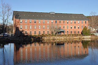
The Andover Village Industrial District encompasses one of the 19th century industrial mill villages of Andover, Massachusetts known locally as "The Village". The growth of this village contributed to the decision in the 19th century to separate the more rural area of North Andover from the town. It is centered on a stretch of the Shawsheen River between North Main Street on the east and Moraine Street on the west. Most of the district's properties lie on Stevens Street, Red Spring Road, Shawsheen Road, and Essex Street, with a few properties also located on adjacent roads.

Andover Town Hall is the historic town hall of Andover, Massachusetts. It is located at 20 Main Street, between Park and Barnard Streets. The 2+1⁄2 story Romanesque Revival red brick building was constructed in 1858, not long after the separation of North Andover. It was designed by Boston architect Theodore Voelkers and built by local builders Abbott & Clement. The building design echoed that of the mills that dotted the town. It was listed on the National Register of Historic Places in 1982.

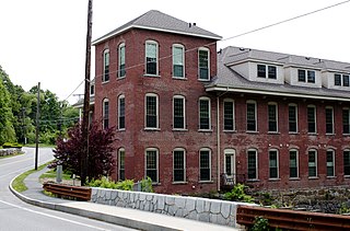
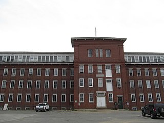
The Bradlee School is a historic former school build at 147 Andover Street in the Ballardvale section of Andover, Massachusetts, United States. The school was built by the town in 1890, and is a fine period example of Queen Anne styling, with a tall hipped roof, rounded windows on the first floor, and decorative brick details. It was listed on the National Register of Historic Places in 1982.

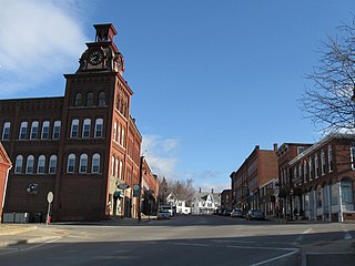
The Central Street District is a historic district encompassing the traditional heart of Andover, Massachusetts prior to the development in the later 19th century of the current town center. It consists mainly of residential and religious properties along Central Street, from Phillips Street in the south to Essex Street in the north. All of the listed properties have frontage on Central Street, even if their addresses are on one of the adjacent streets.

The Machine Shop Village District is a historic district roughly bounded by Main, Pleasant, Clarendon, Water, 2nd Streets, and B&M Railroad in North Andover, Massachusetts. The district encompasses a well-preserved former textile mill village developed in the mid-19th century, with a variety of worker and upper-class housing, and two historic mill complexes. It was added to the National Register of Historic Places in 1982.

The Ipswich Mills Historic District encompasses a major textile mill complex and associated worker housing along the Ipswich River near the center of Ipswich, Massachusetts. The district includes the factories of the Ipswich Mill Company, and several blocks of modest worker cottages mostly on side streets off Estes and Kimball Streets. The site had been used as for mills since the 17th century, and was purchased by the Ipswich Mill Company in 1868. Mill worker housing was built surrounding the complex through the early 20th century, when River Court, Peatfield Street, and 1st through 6th Streets were laid out. The district was listed on the National Register of Historic Places in 1996.

The North Canal Historic District of Lawrence, Massachusetts, encompasses the historic industrial heart of the city. It is centered on the North Canal and the Great Stone Dam, which provided the waterpower for its many mill complexes. The canal was listed on the National Register of Historic Places in 1975, while the district was first listed in 1984, and then expanded slightly in 2009.

The West Parish Center District encompasses the social and religious center of the part of Andover, Massachusetts, that is located west of the Shawsheen River. It is mostly spread along Lowell Street on either side of a major intersection with four other roads: Shawsheen Road, Reservation Road, Beacon Street, and High Plain Road. The centerpiece of the district is the 1826 West Parish Church, which is the oldest church standing in Andover. It is an elegant Federal style granite structure topped with a wooden steeple, added in 1863. The roof is made of Spanish tile, which was probably part of changes made around 1908. Opposite the church on the south side of the common is the West Parish Cemetery, which began as a small burying ground in the 1790s, and was substantially enlarged and restyled in the early 1900s.

Shawsheen Village Historic District is a historic district in northern Andover, Massachusetts. Shawsheen Village was completed in the early 1920s as a planned corporate community. Conceived by William Madison Wood of the American Woolen Company, the village was designed a team of architects including Adden & Parker, Clifford Allbright and Ripley & LeBoutillier of Boston and James E. Allen of Lawrence. John Franklin, a civil engineer for the American Woolen Company was responsible for designing the village, under the direction of Wood. Buildings from the original Frye Village were also incorporated into the design which included a railroad station, shops, apartment buildings, factories, parks and numerous single-family dwellings. The village was located just up the road from the Company's main factories in nearby Lawrence.
The Brookside Historic District of Westford, Massachusetts encompasses surviving elements of the 19th century Brookside mill village, the smallest of the town's three 19th-century industrial villages. Developed between about 1860 and 1904, it includes surviving mill buildings and a variety of mill-related worker housing. The district was listed on the National Register of Historic Places in 2003.
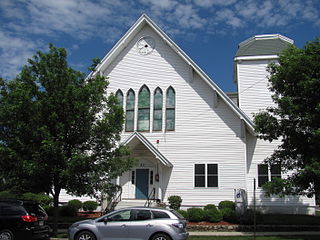
The First Unitarian Church is a historic former church building in Stoneham, Massachusetts. One of Stoneham's more stylish Gothic Revival buildings, the Stick style wood structure was built in 1869 for a Unitarian congregation that was organized in 1858. The building was listed on the National Register of Historic Places in 1984, and included in the Central Square Historic District in 1990. It presently houses the local Community Access Television organization.

The Hamilton Woolen Company Historic District encompasses the well preserved "Big Mill" complex of the Hamilton Woolen Company, built in the mid 19th century. Located at the confluence of McKinstry Brook and the Quinebaug River in central Southbridge, Massachusetts, the complex consists of a cluster of mill buildings and a rare collection of 1830s brick mill worker housing units located nearby. The district was listed on the National Register of Historic Places in 1989.
The Suncook Village Commercial–Civic Historic District encompasses the civic and commercial heart of Suncook, New Hampshire, a village on the Suncook River in Pembroke and Allenstown. The civic district is a 3-acre (1.2 ha) area on the Pembroke side of the river, adjacent to the Pembroke Mill, a site that had seen industrial use since the 18th century. The district includes 21 commercial buildings, 19 of which are historically significant. The district was listed on the National Register of Historic Places in 2005.

The Exeter Waterfront Commercial Historic District encompasses the historic commercial and residential waterfront areas of Exeter, New Hampshire. The district extends along the north side of Water Street, roughly from Main Street to Front Street, and then along both sides of Water and High streets to the latter's junction with Portsmouth Street. It also includes properties on Chestnut Street on the north side of the Squamscott River. This area was where the early settlement of Exeter took place in 1638, and soon developed as a shipbuilding center. The district was listed on the National Register of Historic Places in 1980. It was enlarged in 1986 to include the mill complex of the Exeter Manufacturing Company on Chestnut Street.
The Salmon Falls Mill Historic District encompasses a historic mill complex on Front Street in Rollinsford, New Hampshire. The complex includes four major structures and seven smaller ones, on about 14 acres (5.7 ha) of land along the Salmon Falls River. They were built between about 1840 and the mid-1860s, and have an unusual architectural unity, for additions made to the buildings were done with attention to matching design elements from the existing structures. The Number 2 Mill, built in 1848, was an early location where a turbine was used instead of a waterwheel to provide power to the mill machinery. The district was listed on the National Register of Historic Places in 1980.

The Nashua Gummed and Coated Paper Company Historic District encompasses a collection of former industrial buildings on the north side of the Nashua River in Nashua, New Hampshire. Located on Franklin and Front Streets west of Main Street, the complex was developed by the Nashua Gummed and Coated Paper Company, later the Nashua Corporation, beginning in the late 19th century. It was a major manufacturing and employment center for the city until mid-1990s, when the company's business declined. One of its former storehouses was converted to residences in the 2000s, and the main complex is, in 2015-16, undergoing the same process. The complex of surviving buildings was listed on the National Register of Historic Places in 2015.


