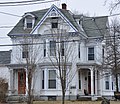
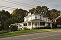
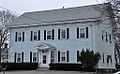
[ 3] Name on the Register Image Date listed [ 4] Location City or town Description 1 Almshouse Almshouse April 13, 1984 (# 84002464 136 Elm St. 42°29′30″N 71°05′17″W / 42.491667°N 71.088056°W / 42.491667; -71.088056 (Almshouse ) 2 Padilla Beard House Padilla Beard House April 13, 1984 (# 84002507 18 Maple St. 42°28′43″N 71°06′07″W / 42.478475°N 71.102082°W / 42.478475; -71.102082 (Padilla Beard House ) 3 Boston and Maine Railroad Depot Boston and Maine Railroad Depot April 13, 1984 (# 84002510 36 Pine St. 42°28′42″N 71°05′50″W / 42.478333°N 71.097222°W / 42.478333; -71.097222 (Boston and Maine Railroad Depot ) 4 John Bottume House John Bottume House April 13, 1984 (# 84002513 4 Woodland Rd. 42°27′14″N 71°05′30″W / 42.453889°N 71.091667°W / 42.453889; -71.091667 (John Bottume House ) 5 C.H. Brown Cottage C.H. Brown Cottage April 13, 1984 (# 84002525 34 Wright St. 42°28′44″N 71°06′07″W / 42.478966°N 71.101974°W / 42.478966; -71.101974 (C.H. Brown Cottage ) 6 William Bryant Octagon House William Bryant Octagon House April 13, 1984 (# 84002526 2 Spring St. 42°28′54″N 71°05′40″W / 42.481667°N 71.094444°W / 42.481667; -71.094444 (William Bryant Octagon House ) 7 Charles Buck House Charles Buck House April 13, 1984 (# 84002527 68 Pleasant St. 42°28′46″N 71°05′36″W / 42.479444°N 71.093333°W / 42.479444; -71.093333 (Charles Buck House ) 8 Clara Buswell House Clara Buswell House April 13, 1984 (# 84002528 481 Main St. 42°28′31″N 71°06′05″W / 42.475278°N 71.101389°W / 42.475278; -71.101389 (Clara Buswell House ) 9 Central Square Historic District Central Square Historic District January 17, 1990 (# 89002277 Roughly bounded by Main, Central, Church, Winter and Common Sts. 42°28′51″N 71°05′59″W / 42.48073°N 71.099698°W / 42.48073; -71.099698 (Central Square Historic District ) 10 Samuel Chamberlain House Samuel Chamberlain House April 13, 1984 (# 84002536 3 Winthrop St. 42°28′31″N 71°06′10″W / 42.475357°N 71.102639°W / 42.475357; -71.102639 (Samuel Chamberlain House ) 11 Bernard Cogan House Bernard Cogan House April 13, 1984 (# 84002546 10 Flint Ave. 42°28′59″N 71°06′04″W / 42.483167°N 71.101081°W / 42.483167; -71.101081 (Bernard Cogan House ) 12 James Cogan House James Cogan House April 13, 1984 (# 84002550 48 Elm St. 42°29′14″N 71°05′50″W / 42.487222°N 71.097222°W / 42.487222; -71.097222 (James Cogan House ) 13 Colonial Beacon Gas Station Colonial Beacon Gas Station April 13, 1984 (# 84002554 474 Main St. 42°28′33″N 71°06′02″W / 42.47582°N 71.10054°W / 42.47582; -71.10054 (Colonial Beacon Gas Station ) 14 George Cowdrey House George Cowdrey House April 13, 1984 (# 84002557 42 High St. 42°29′33″N 71°05′41″W / 42.492416°N 71.09485°W / 42.492416; -71.09485 (George Cowdrey House ) 15 Blake Daniels Cottage Blake Daniels Cottage April 13, 1984 (# 84002562 111–113 Elm St. 42°29′20″N 71°05′29″W / 42.488889°N 71.091389°W / 42.488889; -71.091389 (Blake Daniels Cottage ) 16 Silas Dean House Silas Dean House April 13, 1984 (# 84002565 8 Pine St. 42°28′51″N 71°05′52″W / 42.480833°N 71.097778°W / 42.480833; -71.097778 (Silas Dean House ) 17 Dow Block Dow Block April 13, 1984 (# 84002570 Central Square 42°28′45″N 71°06′02″W / 42.479167°N 71.100556°W / 42.479167; -71.100556 (Dow Block ) 18 E. A. Durgin House E. A. Durgin House April 13, 1984 (# 84002572 113 Summer St. 42°28′42″N 71°05′40″W / 42.478333°N 71.094444°W / 42.478333; -71.094444 (E. A. Durgin House ) 19 Amasa Farrier Boardinghouse Amasa Farrier Boardinghouse April 13, 1984 (# 84002601 280 Main St. 42°29′01″N 71°06′00″W / 42.483507°N 71.100129°W / 42.483507; -71.100129 (Amasa Farrier Boardinghouse ) 20 Amasa Farrier House Amasa Farrier House April 13, 1984 (# 84002605 55 Central St. 42°28′53″N 71°05′55″W / 42.481389°N 71.098611°W / 42.481389; -71.098611 (Amasa Farrier House ) 21 First Baptist Church First Baptist Church April 13, 1984 (# 84002607 461 Main St. 42°28′36″N 71°06′03″W / 42.476671°N 71.100794°W / 42.476671; -71.100794 (First Baptist Church ) 22 First Congregational Church First Congregational Church April 13, 1984 (# 84002609 Main and Church Sts. 42°28′51″N 71°06′00″W / 42.48073°N 71.09996°W / 42.48073; -71.09996 (First Congregational Church ) 23 First Unitarian Church First Unitarian Church April 13, 1984 (# 84002612 Central and Common Sts. 42°28′52″N 71°05′55″W / 42.481111°N 71.098611°W / 42.481111; -71.098611 (First Unitarian Church ) 24 Michael Foley Cottage Michael Foley Cottage April 13, 1984 (# 84002614 14 Emerson St. 42°28′47″N 71°05′54″W / 42.479686°N 71.09826°W / 42.479686; -71.09826 (Michael Foley Cottage ) 25 Walter K. Foster House Walter K. Foster House April 13, 1984 (# 84002616 57 Central St. 42°28′54″N 71°05′56″W / 42.481667°N 71.098889°W / 42.481667; -71.098889 (Walter K. Foster House ) 26 Enoch Fuller House Enoch Fuller House April 13, 1984 (# 84002619 72 Pine St. 42°28′32″N 71°05′55″W / 42.475556°N 71.098611°W / 42.475556; -71.098611 (Enoch Fuller House ) 27 William Griffin Fuller House William Griffin Fuller House April 13, 1984 (# 84002621 32 Franklin St. 42°28′43″N 71°05′57″W / 42.478611°N 71.099167°W / 42.478611; -71.099167 (William Griffin Fuller House ) 28 Charles Gill House Charles Gill House April 13, 1984 (# 84002623 76 Pleasant St. 42°28′38″N 71°05′35″W / 42.477222°N 71.093056°W / 42.477222; -71.093056 (Charles Gill House ) 29 Onslow Gilmore House Onslow Gilmore House April 13, 1984 (# 84002625 477 Main St. 42°28′32″N 71°06′04″W / 42.475452°N 71.101009°W / 42.475452; -71.101009 (Onslow Gilmore House ) 30 Jonathan Green House Jonathan Green House April 13, 1984 (# 84002627 63 Perkins St. 42°28′01″N 71°04′50″W / 42.466944°N 71.080556°W / 42.466944; -71.080556 (Jonathan Green House ) 31 Lorenzo D. Hawkins House Lorenzo D. Hawkins House April 13, 1984 (# 84002639 1 Cedar Ave. 42°28′48″N 71°06′16″W / 42.48°N 71.104444°W / 42.48; -71.104444 (Lorenzo D. Hawkins House ) 32 Benjamin Hibbard Residence Benjamin Hibbard Residence April 13, 1984 (# 84002642 5–7 Gerry St. 42°28′30″N 71°06′01″W / 42.475°N 71.100278°W / 42.475; -71.100278 (Benjamin Hibbard Residence ) 33 Sidney A. Hill House Sidney A. Hill House April 13, 1984 (# 84002645 31 Chestnut St. 42°28′44″N 71°06′16″W / 42.478889°N 71.104444°W / 42.478889; -71.104444 (Sidney A. Hill House ) 34 House at 269 Green Street House at 269 Green Street April 13, 1984 (# 84002682 269 Green St. 42°29′27″N 71°05′05″W / 42.490834°N 71.084733°W / 42.490834; -71.084733 (House at 269 Green Street ) 35 House at 6 S. Marble Street House at 6 S. Marble Street April 13, 1984 (# 84002690 6 S. Marble St. 42°28′20″N 71°06′20″W / 42.472176°N 71.105472°W / 42.472176; -71.105472 (House at 6 S. Marble Street ) 36 House at 114 Marble Street House at 114 Marble Street April 13, 1984 (# 84002661 114 Marble St. 42°28′23″N 71°06′22″W / 42.473078°N 71.106051°W / 42.473078; -71.106051 (House at 114 Marble Street ) 37 House at 19 Tremont Street House at 19 Tremont Street April 13, 1984 (# 84002671 19 Tremont St. 42°29′09″N 71°05′49″W / 42.485833°N 71.096944°W / 42.485833; -71.096944 (House at 19 Tremont Street ) 38 House at 107 William Street House at 107 William Street April 13, 1984 (# 84002660 107 William St. 42°29′03″N 71°05′56″W / 42.484167°N 71.098889°W / 42.484167; -71.098889 (House at 107 William Street ) 39 House at 391 William Street House at 391 William Street April 13, 1984 (# 84002688 391 William St. 42°29′23″N 71°06′39″W / 42.489722°N 71.110833°W / 42.489722; -71.110833 (House at 391 William Street ) 40 Franklin B. Jenkins House Franklin B. Jenkins House April 13, 1984 (# 84002702 35 Chestnut St. 42°28′44″N 71°06′14″W / 42.47895°N 71.103927°W / 42.47895; -71.103927 (Franklin B. Jenkins House ) 41 Franklin B. Jenkins House Franklin B. Jenkins House April 13, 1984 (# 84002699 2 Middle St. 42°28′31″N 71°05′59″W / 42.475278°N 71.099722°W / 42.475278; -71.099722 (Franklin B. Jenkins House ) 42 John Jones House John Jones House April 13, 1984 (# 84002708 1 Winthrop St. 42°28′31″N 71°06′09″W / 42.475199°N 71.102618°W / 42.475199; -71.102618 (John Jones House ) 43 Thomas W. Jones House Thomas W. Jones House April 13, 1984 (# 84002716 34 Warren St. 42°28′31″N 71°06′09″W / 42.475278°N 71.1025°W / 42.475278; -71.1025 (Thomas W. Jones House ) 44 Walter Keene House Walter Keene House April 13, 1984 (# 84002719 28 High St. 42°29′23″N 71°05′44″W / 42.489722°N 71.095556°W / 42.489722; -71.095556 (Walter Keene House ) 45 David Kenney House David Kenney House April 13, 1984 (# 84002725 67 Summer St. 42°28′30″N 71°05′42″W / 42.475°N 71.095°W / 42.475; -71.095 (David Kenney House ) 46 Elisha Knight Homestead Elisha Knight Homestead April 13, 1984 (# 84002863 170 Franklin St. 42°28′28″N 71°05′10″W / 42.47458°N 71.0862°W / 42.47458; -71.0862 (Elisha Knight Homestead ) Listed in error as "Elisha Wright Homestead". 47 Newton Lamson House Newton Lamson House April 13, 1984 (# 84002727 33 Chestnut St. 42°28′46″N 71°06′16″W / 42.479444°N 71.104444°W / 42.479444; -71.104444 (Newton Lamson House ) 48 Locke-Baldwin-Kinsley House Locke-Baldwin-Kinsley House April 13, 1984 (# 84002742 45 Green St. 42°29′00″N 71°05′24″W / 42.483333°N 71.09°W / 42.483333; -71.09 (Locke-Baldwin-Kinsley House ) 49 T.U. Lyon House T.U. Lyon House April 13, 1984 (# 84002743 9 Warren St. 42°28′39″N 71°06′07″W / 42.4775°N 71.101944°W / 42.4775; -71.101944 (T.U. Lyon House ) 50 Metropolitan District Commission Pumping House Metropolitan District Commission Pumping House April 13, 1984 (# 84002747 Woodland Rd. 42°27′21″N 71°05′27″W / 42.455833°N 71.090833°W / 42.455833; -71.090833 (Metropolitan District Commission Pumping House ) 51 Middlesex Fells Reservation Parkways Middlesex Fells Reservation Parkways February 4, 2003 (# 02001749 E. Border Rd., Fellsway E., Fellsway W., Hillcrest Parkway, South St., Pond St., S. Border Rd., Ravine Rd., and Woodland Rd. 42°26′43″N 71°06′10″W / 42.445278°N 71.102778°W / 42.445278; -71.102778 (Middlesex Fells Reservation Parkways ) Extends into Malden , Medford , Melrose , and Winchester . 52 Middlesex Fells Reservoirs Historic District Middlesex Fells Reservoirs Historic District January 18, 1990 (# 89002249 Roughly bounded by Pond St., Woodland Rd., Interstate 93 , and Massachusetts Route 28 42°27′18″N 71°05′43″W / 42.455°N 71.095278°W / 42.455; -71.095278 (Middlesex Fells Reservoirs Historic District ) Roughly the portion of the Middlesex Fells Reservation east of I-93. 53 Millard-Souther-Green House Millard-Souther-Green House April 13, 1984 (# 84002752 218 Green St. 42°29′14″N 71°05′14″W / 42.487222°N 71.087222°W / 42.487222; -71.087222 (Millard-Souther-Green House ) 54 Nobility Hill Historic District Nobility Hill Historic District February 9, 1990 (# 89002328 Roughly bounded by Chestnut and Maple Sts. and Cedar Ave. 42°28′46″N 71°06′19″W / 42.479444°N 71.105278°W / 42.479444; -71.105278 (Nobility Hill Historic District ) 55 Oddfellows Building Oddfellows Building April 13, 1984 (# 84002765 Central Square 42°28′51″N 71°05′59″W / 42.480833°N 71.099722°W / 42.480833; -71.099722 (Oddfellows Building ) 56 Old Burying Ground Old Burying Ground April 13, 1984 (# 84002766 Pleasant and William Sts. 42°28′53″N 71°05′48″W / 42.481389°N 71.096667°W / 42.481389; -71.096667 (Old Burying Ground ) 58 South School South School April 13, 1984 (# 84002828 9–11 Gerry St. 42°28′31″N 71°05′59″W / 42.475167°N 71.099786°W / 42.475167; -71.099786 (South School ) 59 Spot Pond Archeological District Spot Pond Archeological District July 24, 1992 (# 92000925 Virginia Woods section of Middlesex Fells Reservation 42°27′22″N 71°05′13″W / 42.456°N 71.087°W / 42.456; -71.087 (Spot Pond Archeological District ) 60 John Steele House John Steele House April 13, 1984 (# 84002829 2–4 Montvale St. 42°28′54″N 71°06′04″W / 42.481667°N 71.101111°W / 42.481667; -71.101111 (John Steele House ) 61 Stoneham Firestation Stoneham Firestation April 13, 1984 (# 84002831 Central and Emerson Sts. 42°28′46″N 71°05′59″W / 42.479444°N 71.099722°W / 42.479444; -71.099722 (Stoneham Firestation ) 62 Stoneham Public Library Stoneham Public Library April 13, 1984 (# 84002832 Main and Maple Sts. 42°28′39″N 71°06′04″W / 42.4775°N 71.101111°W / 42.4775; -71.101111 (Stoneham Public Library ) 63 Warren Sweetser House Warren Sweetser House May 26, 2005 (# 05000466 90 Franklin St. 42°28′39″N 71°05′48″W / 42.4775°N 71.096667°W / 42.4775; -71.096667 (Warren Sweetser House ) 64 Jesse Tay House Jesse Tay House April 13, 1984 (# 84002834 51 Elm St. 42°29′13″N 71°05′48″W / 42.486944°N 71.096667°W / 42.486944; -71.096667 (Jesse Tay House ) 65 R.P. Turnbull House R.P. Turnbull House April 13, 1984 (# 84002839 6 Pine St. 42°28′53″N 71°05′52″W / 42.481389°N 71.097778°W / 42.481389; -71.097778 (R.P. Turnbull House ) 66 Caleb Wiley House Caleb Wiley House April 13, 1984 (# 84002848 125 North St. 42°29′54″N 71°06′27″W / 42.498333°N 71.1075°W / 42.498333; -71.1075 (Caleb Wiley House ) 67 Micah Williams House Micah Williams House April 13, 1984 (# 84002851 342 William St. 42°29′21″N 71°06′28″W / 42.489204°N 71.107789°W / 42.489204; -71.107789 (Micah Williams House ) 68 Williams-Linscott House Williams-Linscott House April 13, 1984 (# 84002853 357 William St. 42°29′21″N 71°06′29″W / 42.489283°N 71.107918°W / 42.489283; -71.107918 (Williams-Linscott House ) Demolished; architectural parts preserved. 69 Charles Wood House Charles Wood House April 13, 1984 (# 84002860 34 Chestnut St. 42°28′46″N 71°06′12″W / 42.479488°N 71.103335°W / 42.479488; -71.103335 (Charles Wood House )