Ballardvale is a village located within the boundaries of the town of Andover, Essex County, Massachusetts, United States. Growing originally in the 19th century around mills located on the Shawsheen River, the village is a local historic district, boasting many varieties of historic architecture and a rich industrial heritage.

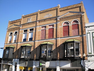
The Oregon Commercial Historic District is a historic district in Oregon, Illinois, that has been listed on the National Register of Historic Places since 2006. The district is roughly bordered by Jefferson, Franklin, 5th and 3rd Streets in Oregon. It is one of six Oregon sites listed on the National Register and one of three to be so listed since the turn of the 21st century. The other two are the Oregon Public Library, listed in 2003, and the Chana School, listed in 2005.

Mount Pleasant Historic District is a historic district encompassing a cluster of well-preserved 19th-century residential buildings on Forest Street and Mount Pleasant Avenue in the Roxbury neighborhood of Boston, Massachusetts. First developed in 1833, it was one Roxbury's first speculative residential subdivision developments. The district features Greek Revival, Italianate, and Romanesque architecture, and was added to the National Register of Historic Places in 1989.

St. Mary's Roman Catholic Church Complex is a historic multi-building church complex at 133 School Street in Waltham, Massachusetts. Established as a parish in 1835, it is the city's oldest Roman Catholic establishment. Its 1858 Romanesque Revival church and 1872 Second Empire rectory are particularly fine architectural examples of their styles. The complex was listed on the National Register of Historic Places in 1989.

The Charlemont Village Historic District is a historic district on Massachusetts Route 2 between South Street and Harmony Lane, encompassing much of the village center of Charlemont, Massachusetts, United States. The district's properties represent the growth of the village center from its rural origin through a period of 19th century industrialization, including 18th and 19th century farmsteads, Greek Revival buildings of the mid 19th century, and later 19th century Victorian architectural styles. The district was added to the National Register of Historic Places in 1988.

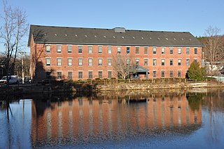
The Andover Village Industrial District encompasses one of the 19th century industrial mill villages of Andover, Massachusetts known locally as "The Village". The growth of this village contributed to the decision in the 19th century to separate the more rural area of North Andover from the town. It is centered on a stretch of the Shawsheen River between North Main Street on the east and Moraine Street on the west. Most of the district's properties lie on Stevens Street, Red Spring Road, Shawsheen Road, and Essex Street, with a few properties also located on adjacent roads.

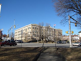
Andover Town Hall is the historic town hall of Andover, Massachusetts. It is located at 20 Main Street, between Park and Barnard Streets. The 2+1⁄2 story Romanesque Revival red brick building was constructed in 1858, not long after the separation of North Andover. It was designed by Boston architect Theodore Voelkers and built by local builders Abbott & Clement. The building design echoed that of the mills that dotted the town. It was listed on the National Register of Historic Places in 1982.
The Diamond Historic District is a seaside, 69.5-acre (28.1 ha) National Register historic district in Lynn, Massachusetts. Established by the National Park Service in 1996, the district is situated between downtown Lynn and the Atlantic Ocean—bounded roughly by Broad and Lewis Streets to the north, Lynn Shore Drive to the southeast, Nahant Street to the west, and Eastern Avenue to the east. The Diamond Historic District encompasses 590 contributing resources.
Downtown Salem District is a historic district roughly bounded by Church, Central, New Derby, and Washington Streets in Salem, Massachusetts. It was added to the National Register of Historic Places in 1983, and represents a major expansion of the Old Town Hall Historic District, which was listed in 1972.

The Federal Street District is a residential and civic historic district in Salem, Massachusetts, United States. It is an expansion of an earlier listing of the Essex County Court Buildings on the National Register of Historic Places in 1976. In addition to the former county court buildings included in the earlier listing, the district expansion in 1983 encompasses the entire block of Federal Street between Washington and North Streets. It includes buildings from 32 to 65 Federal Street, as well as the Tabernacle Church at 50 Washington Street.

The Musgrove Block is a historic commercial building at 2 Main Street in the center of Andover, Massachusetts. The three-story brick building was built in 1895 on the site of a former town green, and forms part of Andover's central Elm Square intersection. The building exhibits Romanesque Revival styling, featuring granite trim elements and ornate brick detailing. It was listed on the National Register of Historic Places in 1982.

The Main Street–Locke Street Historic is a residential historic district in Andover, Massachusetts. It is located along Main Street north of Academy Hill, between Morton Street and Punchard Avenue. It also includes several houses on Locke Street, Punchard, and Chapman Avenue.
The Main Street Historic District in Haverhill, Massachusetts represents the civic core of Haverhill and a gateway to the city's Highlands neighborhood and lakes district. Overlooking a mid-20th century urban renewal clearance area northeast of the main business and industrial district of the city, it was listed on the National Register of Historic Places in 2003.

The Machine Shop Village District is a historic district roughly bounded by Main, Pleasant, Clarendon, Water, 2nd Streets, and B&M Railroad in North Andover, Massachusetts. The district encompasses a well-preserved former textile mill village developed in the mid-19th century, with a variety of worker and upper-class housing, and two historic mill complexes. It was added to the National Register of Historic Places in 1982.

The West Parish Center District encompasses the social and religious center of the part of Andover, Massachusetts, that is located west of the Shawsheen River. It is mostly spread along Lowell Street on either side of a major intersection with four other roads: Shawsheen Road, Reservation Road, Beacon Street, and High Plain Road. The centerpiece of the district is the 1826 West Parish Church, which is the oldest church standing in Andover. It is an elegant Federal style granite structure topped with a wooden steeple, added in 1863. The roof is made of Spanish tile, which was probably part of changes made around 1908. Opposite the church on the south side of the common is the West Parish Cemetery, which began as a small burying ground in the 1790s, and was substantially enlarged and restyled in the early 1900s.
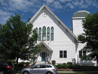
The First Unitarian Church is a historic former church building in Stoneham, Massachusetts. One of Stoneham's more stylish Gothic Revival buildings, the Stick style wood structure was built in 1869 for a Unitarian congregation that was organized in 1858. The building was listed on the National Register of Historic Places in 1984, and included in the Central Square Historic District in 1990. It presently houses the local Community Access Television organization.

Hartwell and Richardson was a Boston, Massachusetts architectural firm established in 1881, by Henry Walker Hartwell (1833–1919) and William Cummings Richardson (1854–1935). The firm contributed significantly to the current building stock and architecture of the greater Boston area. Many of its buildings are listed on the National Register of Historic Places.
The Hartford City Courthouse Square Historic District is located in Hartford City, Indiana. Hartford City has a population of about 7,000 and is the county seat of Blackford County and the site of the county courthouse. The National Park Service of the United States Department of the Interior added the Hartford City Courthouse Square Historic District to the National Register of Historic Places on June 21, 2006 — meaning the buildings and objects that contribute to the continuity of the district are worthy of preservation because of their historical and architectural significance. The District has over 60 resources, including over 40 contributing buildings, over 10 non-contributing buildings, 1 contributing object, 8 non-contributing objects, and two other buildings that are listed separately in the National Register.

The Watertown Center Historic District encompasses the historic village center of Watertown, Connecticut. It exhibits architectural and historic changes from the early 1700s into the 20th century. It is roughly bounded by Main, Warren, North, Woodbury, Woodruff, and Academy Hill Roads, and was listed on the National Register of Historic Places in 2001.

Rufus Sargent (1812-1886) was an American architect practicing in Newburyport, Massachusetts during the nineteenth century.


